Unpaved road erosion after heavy storms in mountain areas of northern China
2022-09-26ChunmiWnBoyunLiuQinkYnGuowiPnYonqinLonLiWnRichrdCrusWiqinDnXinLiuEnhnWn
Chunmi Wn ,Boyun Liu ,Qink Yn ,Guowi Pn ,Yonqin Lon ,Li Wn ,Richrd M.Crus ,Wiqin Dn ,Xin Liu ,Enhn Wn
a Shaanxi Key Laboratory of Earth Surface System and Environmental Carrying Capacity,College of Urban and Environmental Sciences,Northwest University,Xi'an,710127,PR China
b Key Laboratory of National Forestry and Grassland Administration on Ecological Hydrology and Disaster Prevention in Arid Regions,Xi'an,710048,PR China
c Advanced Institute of Natural Sciences,Beijing Normal University at Zhuhai,Zhuhai,519087,PR China
d State Key Laboratory of Earth Surface Processes and Resource Ecology,School of Geography,Beijing Normal University,Beijing,100875,PR China
e Department of Agronomy,Iowa State University,Ames,IA,50011,USA
f Suide Experimental Station for Soil and Water Conservation,the Yellow River Conservancy Commission,Yulin,Shaanxi,719000,PR China
g Key Laboratory of Sustainable Forest Ecosystem Management-Ministry of Education,Northeast Forestry University,Harbin,Heilongjiang,150040,PR China
Keywords:Unpaved road erosion Heavy storm Gully Land management Climate change
A B S T R A C T More frequent extreme rainfall events associated with global climate change cause greater challenges for soil conservation.Severe erosion occurs on many unpaved roads since these structures create important water flow paths during heavy storms.The present research aimed to investigate the intensity and influencing factors of unpaved road erosion under varied land use and management conditions(sloping cropland,terraced cropland,forest& grass).The erosion occurred in the watersheds contributing runoff water to roads after the greatest rainfall event recorded in the mountain area of northern China caused by Typhon Lekima.The research was conducted in an agricultural-forest-dominated watershed based on field investigation and UAV-based image analysis.A road erosion level classification standard was given according to the occurrence of rills,ephemeral gullies,and gullies.Significant erosion happened on 67%of the unpaved roads;42% of them suffered moderate to severe erosion in which ephemeral gullies or gullies developed.The average erosion amount from these roads was 2280.75 t ha-1 and was significantly influenced by the watershed land use type and management.The dominant factor governing unpaved road erosion associated with terraced cropland was vegetation coverage on roads.Drainage area was the most important factor for road erosion in sloping cropland and forest&grass land,and road gradient was also a critical factor.Terraces,and forest & grass in drainage areas significantly reduced unpaved road erosion by 85% and,47%,respectively,compared to sloping cropland.More integrated measures should be used to prevent unpaved road erosion.The results of this research can be applied to road protection against erosion in heavy storms.
1.Introduction
Soil erosion is one of the most severe threats to our environment as it causes an accelerated rate of land degradation(Panagos et al.,2020)and an increased amount of sedimentation in surface waters(Dutta,2016).Since the 20th century,climate change,especially more frequent high-intensity rainfall events,is significantly changing soil erosion rates and presenting greater challenges to soil and water conservation practices(Li & Fang,2016;Nearing et al.,2004).Unpaved roads are essential infrastructure components of cropland and non-cropland systems,but are significant sediment sources,especially during heavy storms(Nosrati & Collins,2019;Zhang et al.,2019).Some research has even reported unpaved road erosion as the dominant source of sediment in selected watersheds(Cao et al.,2015;Yang et al.,2019).Thus,a better understanding of unpaved road erosion especially caused by heavy storms,is an urgent need for optimizing soil erosion models and conservation practices.
Typically,unpaved roads cover only a small portion of an area in a watershed,but their influence on increasing soil erosion should not be ignored(Dunne&Dietrich,1982,pp.41—53).Roads and road systems change the hydrologic surface and slope profiles,usually leading to a concentrated runoff on roadbeds(Montgomery,1994).Much research on road erosion has focused on forest areas(Fransen et al.,2001;Parsakhoo et al.,2014;Varol et al.,2019;Zemke,2016).Several efforts have also analyzed unpaved road erosion in cropland areas and found it excessive(Guo et al.,2020;Nyssen et al.,2002;Zhang et al.,2019).Guo et al.(2020)reported unpaved road erosion could reach 10.8—57.5 times that of background erosion rates in a semi-arid loess area.Ramos-Scharr′on(2018)found this number was 6—200 times that of an adjacent dry forest area,and Motha et al.(2004)reported this number to be 10 to 500 times that of undisturbed forest areas.

Fig.1.Study area.
Several studies have also focused on the factors impacting unpaved road erosion.More than 10 factors have been identified(Fu et al.,2010).A few of them,such as road gradient,drainage area,road surface soil properties,and rainfall characteristics,have also been used in road erosion-related models(Anderson&Macdonald,1998;Cao et al.,2014).For example,in the model proposed by Cao et al.(2014),slope gradient,road segment length,and drainage area were employed to predict road erosion.In the ROADMOD model reported by Anderson and Macdonald(1998)and the model used by Zhang et al.(2019),only road slope gradient and drainage area were used.
While these studies have raised the importance of unpaved road erosion,the mass of erosion from these areas is still not fully known,especially for severe erosion events that create a large number and volume of gullies(Zhang et al.,2019).The logistics of studying road erosion caused by heavy storms across different environments is challenging and therefore still lacking in the literature.The driving factors have not been classified based on land use and management,making effective conservation practice adoption difficult in many areas.To minimize large soil erosion events from unpaved roads,more detailed field surveys of unpaved road erosion after storms are needed to better understand the mechanics of these erosion processes and support the development of badly needed conservation practices that limit soil loss.In this research,we hypothesized that,in heavy storms,unpaved roads become an important water flow path and thus produce severe erosion.It was further anticipated that the unpaved road erosion amount and factors dominating the erosion process should be influenced by land management in the upstream drainage areas.This would include the effects of terraces in agricultural fields that retain surface runoff and thus decrease concentrated flow and help avoid gullying on the unpaved roads.
A heavy storm,associated with Typhon Lekima,with total rainfall of 576 mm at the storm center,occurred on August 10-12,2019,in a mountain area in northern China.This storm resulted in the greatest rainfall for a single event recorded in that area since 1958.This provided a truly unique opportunity to study landscape management impact on unpaved road erosion.The objective of this research was to assess the unpaved road erosion intensity associated with this heavy storm and quantify the driving factors causing unpaved erosion for various land management,including sloping cropland,terraced cropland,and forest& grass land.This research will help optimize strategies to prevent increased unpaved road erosion in the changing global climate.
2.Method
2.1.Study area and road network
The study area is the Zenjiagou watershed with an area of 1.61 km2.It is located in Linqu County,Shandong province of China,at the northern foot of Yi Mountain(36°13′N,118°40′E).The area is dominated by brown loamy soil.Cropland soil bulk density is about 1.36 g cm-3(Zhang et al.,2009).The average annual erosion rate is 18.61 t ha-1in this area,and the annual precipitation is about 592 mm(Han et al.,2020).This watershed was chosen because it is located near the storm center.Cropland dedicated to corn and peanut(with an area portion of 32%)and forest(with an area portion of 52%)dominates this watershed.Apple orchards occupy an area portion of 9%in this watershed.Terraced cropland,the most critical agriculture conservation practice,covers 31% of the watershed.There are 12.91 km of roads in this watershed,and 11.68 km are unpaved with a density of 7.25 km km-2.Unpaved roads are distributed across the watershed with agriculture,forest,and grass in their drainage areas(Fig.1).
2.2.The heavy storm caused by Typhoon Lekima
The heavy storm occurred on August 10-12,2019.The total rainfall was 576 mm at the storm center.The maximum 24-h rainfall from this storm was 507.6 mm,much higher than the previous record 24-h rainfall of 360.3 mm in Linqu county.The cumulative precipitation of this storm was 576 mm,and the maximum instantaneous rainfall intensity was 240 mm h-1,according to the rainfall record in this surveyed watershed.
2.3.Field investigation
A detailed field survey of unpaved road erosion was conducted August 14-22,2019,two days after the heavy storm,and organized by the Ministry of Water Resources(MMR)of China.An unmanned aerial vehicle(UAV)based Digital Orthophoto Map(DOM)and Digital Surface Model(DSM)with a resolution of 9 cm were obtained before the field survey.All roads,land use,and terraces were digitalized using ESRI ArcGIS Desktop10.5.About 30%(in length)of the unpaved road with a total length of 3.42 km was selected for field surveys following stratified sampling.Most roads were 3m wide,except for 215m of roads which are 2m wide.The primary land use and management(including sloping cropland,terraced cropland,and forest & grassland)for the selected roads were considered for classifying strata in the sampling strategy.Then similar portions of unpaved roads were randomly selected in each strata.
After sampling,a detailed field survey was conducted on the selected unpaved road segments.A road segment here refers to a continuous road with similar environmental conditions,including slope,land use,management in the drainage area,vegetation coverage,and presence or absence of ditches constructed along the road,etc.And each road segment should have a unique erosion level.A total number of 70 road segments were surveyed,with start and endpoints of each road segment recorded using a GPS receiver.The width and depth of rills,ephemeral gullies,and gullies were measured using a tape measure at 2-m intervals.Unpaved road bulk density of the top soil layer was measured using a stainlesssteel cylinder(5 cm height and 100 cm3volume).After sampling,the soil was oven-dried at 105°C for 24 h and weighed.Other information collected included the road width,presence or absence of road ditches,picture of each road segment,etc.
2.4.Data processing and parameters calculated
The mean width and depth of rills/ephemeral gullies/gullies and erosion amount for each road segment were calculated based on the field survey(Eqn 1,2,3 and 4.Inter-rill erosion was not considered in this research.

where n is the number of measures on each road segments;Wero(m)andHero(m)refer to averaged incision width and depth of rills/ephemeral gullies/gullies on each road segment,respectively.wi(m)andhi(m)refer to the width and depth of rills/ephemeral gullies/gullies of each measured separately.li(m)refers to the interval between measures,which was 2m.ρ refers to the soil bulk density on the unpaved roads(the measured value averages 1.7 g cm-3).S(m2)refers to the area of the road segment,L(m)andW(m)refer to the length and width of the road segment separately.AndA(t·ha-1)is the erosion amount for each road segment.The cross-sections of rills,ephemeral gullies,and classical gullies were all regarded as rectangles since in this area most of the gullies were almost vertically cut from their edges.
A series of parameters used for driving factors analysis were calculated for each road segment based on UAV-sourced DOM and DSM images.The drainage area per unit length of road(Cl)was calculated based on the DSM.The drainage area per unit length of the road was calculated as(Eqn 5):

WhereCl(m2·m-1)refers to the drainage area per unit length of road;C(m2)refers to drainage area for each road segment andL(m)refers to the length of the road segment.Clwas calculated using hydrology analyses in ESRI ArcGIS Desktop10.5.
The road gradient was determined for ach road segment by measuring the change in elevation and the distance between points along a road where no rills or gullies occurred based on UAV DSM and DOM datasets.At least 4 points were picked for each road segment which split a road segment into at least 3 subsections,and the weighted average using the length of the subsections as the weighting parameter was calculated as the overall road gradient.
Vegetation coverage was calculated by using the VDVI index(visible-band difference vegetation index)based on the UAV sourced DOM image(Mengmeng et al.,2017).FVC(the mean vegetation coverage on the surface of road segments)was calculated by averaging all the pixels on each road segment.And FVC_d(the mean vegetation coverage of each road segment in its drainage area)was calculated by averaging all the pixels locates in the drainage area of each road segment.
2.5.Unpaved road erosion intensity levels
Unpaved road erosion intensity was classified into 4 levels according to the erosion condition and its influence on tractor-traffic capacity(Table 1).We developed the road erosion level standard based on the occurrence of rills,ephemeral gullies,and classical gullies.In the traditional definitions of different types of channels,the influence on tillage was taken into consideration.By using general tillage tools,rills can be eliminated,classical gullies cannot be crossed,and ephemeral gullies can be crossed and filled but reform in the same location repeatedly(Liu et al.,2018).Similarly,the influence on traffic was also taken into consideration in our standard for road erosion types.Classical gullies,ephemeral gullies,and rills in road erosion were defined such that a tractor cannot cross,can cross with difficulty,and can cross easily,respectively.If no obvious channels were observed,the road erosion type was defined as inter-rill.The four erosion levels are illustrated in Fig.2 and can easily be distinguished in fieldwork.

Table 1Road erosion level classification standard.
2.6.Data analysis
A one-way analysis of variance(ANOVA)and least significant difference(LSD)multiple comparisons(P<0.05)were used to assess the effects of land management on the erosion amount.Pearson correlation analysis and redundancy analysis(RDA)were performed to test the relationships between the erosion amount and influencing factors,allowing for a visual representation of changes in erosion amount with different factors in road segments with different land management.The dominant factors,whichinfluence road erosion most were identified based on the described analysis.Correlation analysis was conducted by the IBM SPSS statistics software package 21.0.RDA and CCA were conducted by CANOCO 4.5(Ter Braak,1994).

Fig.2.Typical roads segments with different erosion levels in the field.
3.Results
3.1.Road erosion and its spatial distribution
A total of 70 road segments were randomly chosen with a total length of 3.42 km.Road segments had a range of erosion levels(Table 2).The mean erosion amount was 2280.75 t ha-1.The channel(rill,ephemeral gully,and classical gully)incision depth and width averaged 26.12 cm and 73.00 cm,respectively.Only 32.76% of the unpaved road segments were not significantly eroded,19.97% were moderately eroded with a mean channel incision depth of 32.04 cm and gully width of 101.78 cm,and 22.49% were severely eroded with classical gullies having a mean gully incision depth of 74.12 cm and gully width of 188.71 cm.Classical gullies and ephemeral gullies contribute about 96%of the total measured unpaved road erosion.The mean width of unpaved roads was 2.94 m,the total area of unpaved roads in the Zenjiagou watershed was 3.43 ha.Then approximately 7832 tons of sediment was eroded from these unpaved roads,which made the unpaved roads an important sediment source.
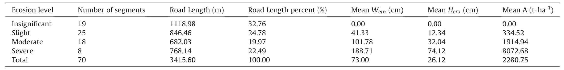
Table 2Road erosion for four erosion levels associated with different road segments.
Fig.3 displays the spatial distribution of unpaved erosion in the Zengjiagou watershed.The most severe road erosion was generally located at the bottom of the watershed,where the drainage areawas generally large.The distribution of erosion varied depending on land use and field management,with the most intensive in the areas with sloping cropland and with less erosion associated with terraced lands.
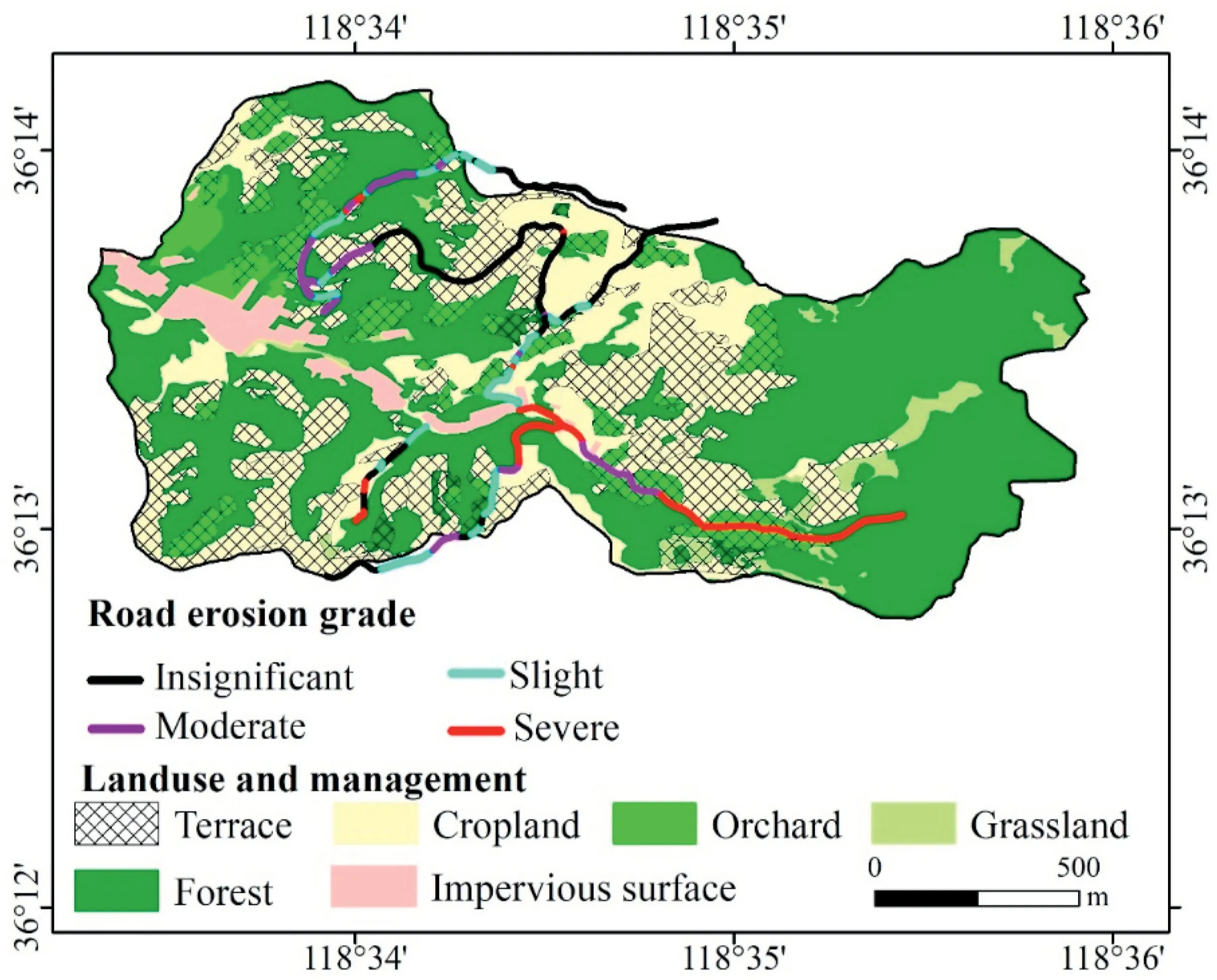
Fig.3.Road erosion spatial distribution.
3.2.Impact of land use and management on unpaved road erosion
Table 3 shows road erosion associated with different land management.Road erosion amount was significantly related to land management in drainage areas of roads.Road erosion amount in areas with sloping cropland was greatest,averaging 5258.10 t ha-1,and the smallest in areas with terraced cropland(782.71 t·ha-1with no road ditches and 453.131 t ha-1with road ditches).In areas with forest & grass land,the average road erosion amount was 2773.45 t ha-1.Compared to areas with sloping cropland,the mean road erosion amount was 47%and 85%lower in forest&grass land and terrace cropland,respectively.In the surveyed unpaved roads,most of the roads with ditches were associated with terraced cropland.Only one road segment with ditches(the length was 32.65 m)was found in forest&grass land.About one-third of roads in terraced cropland had ditches along the roads.Road ditches significantly reduced road erosion;the average erosion amount in road segments with ditches was 453.13 t ha-1,which was 42.11%lower than that occurring with no road ditches in the terraced cropland.The overall average erosion amount on unpaved roads associated with terraced cropland was 670.52 t ha-1.
3.3.Driving factors of road erosion in different land management areas
Table 4 presents the Pearson correlation for road erosion amount and influencing factors under different land management.Based on this statistic,most important factors that influenced the erosion amount varied with field management.Generally,the unpaved road erosion amount was significantly and positively correlated withCland road gradient,and negatively correlated with terrace existence in the drainage area.Clwas overall the most important factor.In terraced cropland,unpaved road erosion amount was significantly and negatively correlated with the mean vegetation coverage for roads(FVC).Road gradient also significantly influenced the road erosion amount,but FVC was a more critical factor.Clwas not a critical factor after terraces were constructed due to flow being dispersed by the terraces.In areas without terraces,including sloping cropland and forest & grass land,the most significant factor wasCl,and road gradient was also important.Both of these factors had a positive relationship with road erosion amount.The statistics of the influencing factors including road gradient,Cl,FVC and FVC_d is shown in Table 5.Fig.4 shows the correlation of road segments erosion amount and the major influencing factors.Linear regression models were used to express the correlation between erosion amount and road gradient in both sloping cropland and forest&grass lands with R2of 0.60 and 0.51,respectively.And a linear regression model expressed the correlation between erosion amount andClin both sloping cropland and forest&grass lands,with R2of 0.78 and 0.67,respectively.And a linear regression model expressed the correlation between erosion amount and FVC in terraced cropland,with R2of 0.16.

Table 3Road erosion amount associated with fields having different management types.
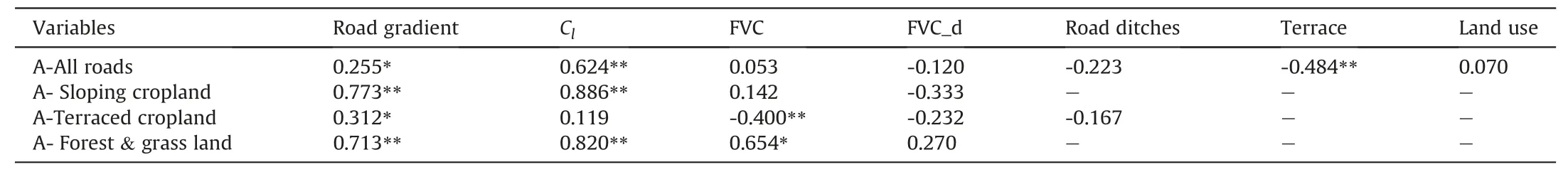
Table 4The Pearson correlation coefficient of road erosion amount and selected variables.

Table 5Statistics of four important influence factors for road erosion.
A redundancy analysis confirmed the relationship between road erosion and the identified factors(Fig.5).The first two axes explained 52.3% of the total variance.The first axis effectively represented the factors related to terrain includingCl,road gradient,and terraces,and the second axis effectively represented FVC,which showed they were key factors affecting road erosion.Road segment plots associated with sloping cropland were mainly clustered in moderate and high erosion amounts and levels.These plots had mostly moderate and high road gradient values andClvalues and smaller values of vegetation coverage with no ditches or terraces.Road segment plots in forest & grass land were mainly clustered in two areas.One of them was highly eroded with highvalues ofCland road gradient.The other cluster plots were slightly eroded with low values of road gradient andCl.Road segment plots in terraced cropland was mainly clustered in two areas.One of them was highly eroded with low values of vegetation coverage.In the other cluster area,road segment plots were slightly eroded with high values of vegetation coverage.In terraced cropland with road ditches,plots clustered in slight(with higher vegetation coverage)and moderate erosion areas(with lower vegetation coverage).
4.Discussion
The finding of this research confirmed our hypothesis that severe erosion occurred on unpaved roads during the heavy storm,and both the erosion amount and dominant factors seem to be significantly influenced by the land management in the road drainage areas.
4.1.The intensive unpaved road erosion caused by the heavy storm
The unpaved road erosion was severe in this heavy storm.The unpaved road erosion amount was 5258.10 t ha-1,and 670.52 t ha-1,respectively,for sloping cropland and terraced cropland.The above unpaved road erosion values were 47 times and 7 times that of the estimated erosion on sloping cropland and terraced cropland,respectively,in a survey conducted by Han et al.(2020)in the same area after this storm.These relative erosion amounts between unpaved roads and hillslope are comparable to what Guo et al.(2020)found in semi-arid loess agriculture areas(10.8—57.5 times)by using in-situ scouring-erosion experiments.The average unpaved road erosion amount in the watershed was 2280.75 t ha-1,This is,124 times the average annual farm field erosion amount in this watershed.The unpaved road erosion amount was about eight times that of the average road erosion reported by Sidle et al.(2004)in a tropical forest watershed.A total of 7832 tons of sediment was eroded from the unpaved road in this watershed,essentially contributing 48.64 t ha-1to the watershed erosion amount,despite only 2%of the watershed being in unpaved roads.In this heavy rainfall,classical gullies and ephemeral gullies dominated unpaved road erosion and contribute about 96% of the total surveyed unpaved road erosion.This result was similar to that observed by Zhang et al.(2019)who observed 92.3% of soil loss in the Loess Plateau was attributed to classical gullies and ephemeral gullies for a heavy rainfall.Under normal precipitation conditions,rill erosion is more important in road erosion(Cao et al.,2014).Based on these findings,unpaved road erosion should be given greater importance in watershed soil and water management plans especially where the potential for heavy rainfall events is high.
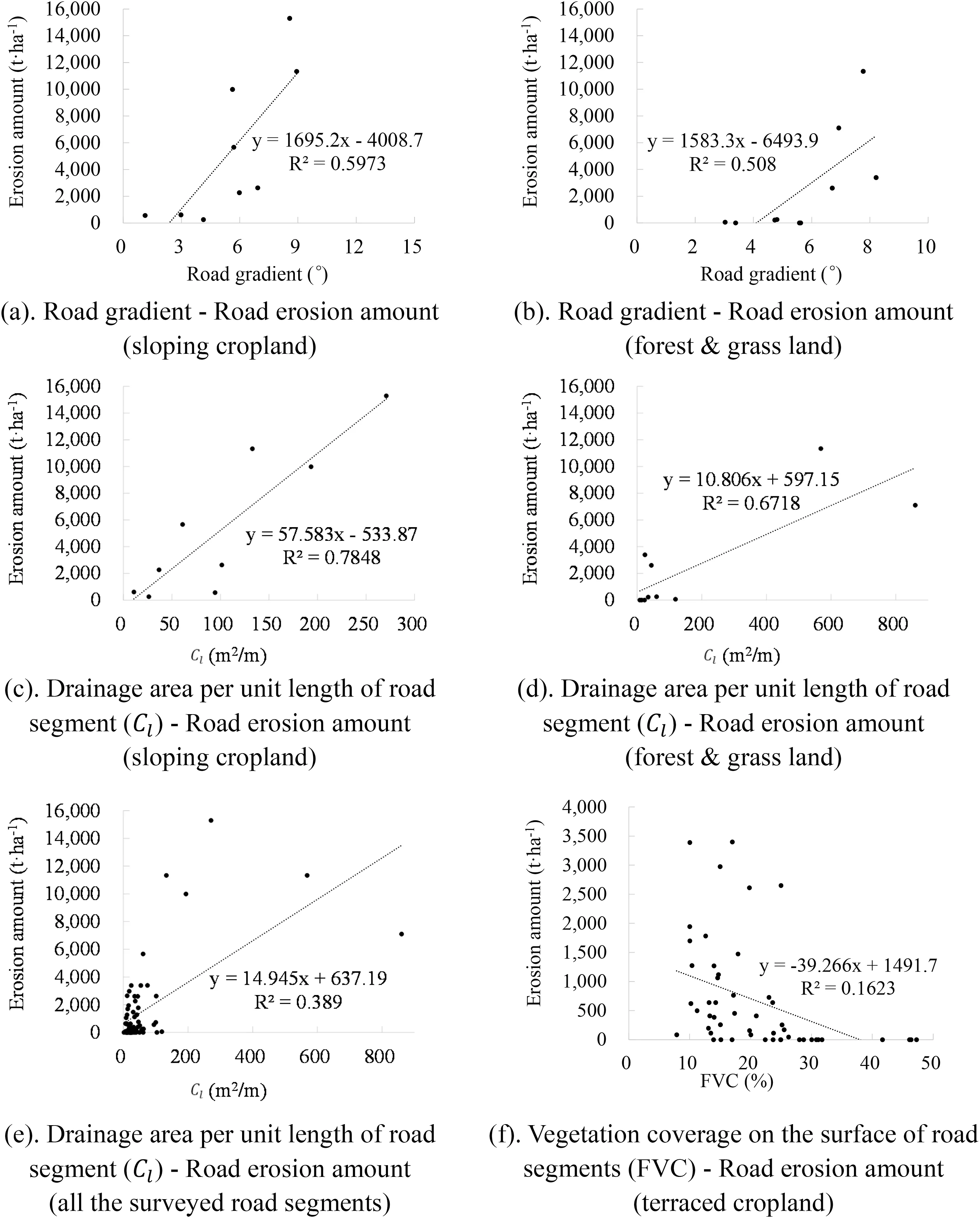
Fig.4.Linear regression between of road erosion amount and three main influencing factors.
4.2.Role of terraces in drainage area for controlling unpaved road erosion

Fig.5.Redundancy analysis(RDA)ordination diagram for the relationships of road erosion properties with the environmental factors.Each symbol presents a road segment in fields with different land management.The red left-pointing triangles represent roads associated with sloping cropland;The green squares represent roads in forest&grass land without ditches;The green dots represent roads with ditches along roads in forest&grass land.The orange squares represent roads without ditches in terraced cropland;The orange dots represent roads with ditches along roads in terraced cropland.
Terraces in unpaved road drainage areas significantly influence unpaved road erosion.Terrace construction reduces the drainage area contributing surface runoff to roads and the runoff flow velocity by shortening the slope length and decreasing the slope gradient(Fu et al.,2020).For example,in this research,the average 6 of road segments associated with terraced cropland was only 34.09 m2m-1,much smaller than that of sloping cropland(143.56 m2m-1).Compared with drainage areas dominated by sloping cropland,terraced drainage areas reduced unpaved road soil erosion by 85%.This impact on road erosion amount occurred while terraces reduced hillslope soil erosion amount only 15.66%,according to Han et al.(2020).Many studies focus on reducing hillslope soil erosion by building terraces(Duan et al.,2020;Fu et al.,2020;Han et al.,2020;Rutebuka et al.,2020).Based on this research,the benefits of terraces in reducing downstream unpaved road damage are greater than that observed by Han et al.(2020)and should be considered accordingly.
Additionally,terraces changed the driving factors of unpaved road erosion.The most critical factor impacting unpaved road erosion in non-terraced areas including sloping cropland and forest&grassland land in this study was drainage area.Road gradient was also an important factor.Similar key factors have also been found by previous research.For example,Cao et al.(2014)also found road gradient and drainage area were important,and the most important factor for unpaved road erosion found by Zhang et al.(2019)was also catchment area.In contrast,for roads with drainage areas having terrace croplands,the critical factor was not drainage area or road gradient but the vegetation coverage on the road surface.Greater vegetation coverage protects the bare soil on the unpaved road surface and helps reduce the cutting from raindrop impact and flowing water.Drainage area for roads in terraced watersheds have less influence because the flow was retained by the terraces which makes the road segment drainage areas much smaller.
4.3.Role of vegetation in controlling unpaved road erosion
Based on the results from this work,forest&grass cover in the drainage area apparently reduced unpaved road soil erosion by 47%compared to that on sloping cropland.This is,less of an impact than terraces but still significant.Vegetation ground cover has been a standard recommendation for soil erosion control(Chen et al.,2018;Zhou et al.,2008),and thus,these results are not surprising.Compared to cropland in the drainage area,forest and grass help reduce peak volume flow and flow velocity,decreasing water power to cut channels in unpaved roads.Slope and drainage area were the most critical factors influencing unpaved road erosion in forest & grass land.Vegetation coverage on the road surface is usually positively correlated with catchment area and road gradient due to higher soil moisture or less human activity in areas with forest & grass-covered fields.For example,the Pearson correlation coefficient betweenCland vegetation cover was 0.62 for road segments in forest & grass lands.That suggests that in these cases,the direct influence of vegetation coverage on road erosion can be weakened and might be a reason vegetation cover has not been considered in many of the unpaved road erosion models.
4.4.Implications for future research
Soil conservation is experiencing greater challenges with global climate change.It seems more intensive unpaved road erosion is occurring due to the increased frequency of extreme rainfall events.High soil erosion from water cutting of unpaved roads,especially during heavy storms,has previously only been a marginally recognized erosion source.However,the results of this research suggest it should be given more attention.Further studies focusing on measurements and experiments on unpaved road erosion in varied environments associated with different precipitation levels are needed to better understand and determine the best approach to soil conservation for the affected areas.Methods for reducing upstream runoff and sediment and flow velocity could include increasing vegetation cover of the unpaved road surface and in the drainage area,engineering such as terracing,improving ditch design and frequency along roads,etc.These could then be integrated into watershed planning when the more extreme events are considered and unpaved road erosion is a significant issue.
5.Conclusions
This study investigated unpaved road erosion caused by an extremely heavy storm in a northern mountain area of China.The unpaved roads in this region experienced intensive erosion due to this heavy storm.The averaged erosion amount was 5258.10,2773.45,and 670.52 t ha-1on unpaved roads associated with sloping cropland,forest & grass,and terraced cropland,respectively.Classical gully and ephemeral gully types of erosion dominated the erosion process on these roads.Our surveys indicate 42%of the unpaved roads were moderately to severely damaged by ephemeral gullies and gullies and that these two features accounted for 96% of the total unpaved road erosion.
Terraces and forest & grassland in areas draining to surveyed road segments,along with road ditches,significantly reduced unpaved erosion by 85%,47%,and 42%,respectively.More integrated measures should be used to prevent or reduce unpaved road erosion in the presence of increasing frequency of extreme events.
The factors driving soil erosion on these road segments were changed by the construction of terraces.For roads associated with areas without terraces,such as sloping croplands and forest&grass land,the catchment area was the most critical factor,and road gradient was also an important factor.In terraced areas,catchment area was not such a critical factor because of the reduction of effective catchment area by terracing.Vegetation coverage on the road surface was the most important factor influencing the road erosion amount in terraced areas.More investigations on unpaved road erosion should be conducted under different environmental conditions to optimize soil conservation strategies to cope with the changing climate.
Declaration of competing interest
None.
Acknowledgments
This research was supported by the National Natural Science Foundation of China,Grant No.41977062,SKL Foundation Grant No.A314021402-2016,the Strategic Priority Research Program of the Chinese Academy of Sciences,Grant No.XDA20040202,Program for Key Science and Technology Innovation Team in Shaanxi Province,Grant No.2014KCT-27.Thanks to the Ministry of Water Resources(MMR)of China for organizing the field survey.Thanks to David L.B.Jupp from CSIRO Land and Water,Australia for reading over the manuscript and giving many suggestions.Part of the work was finished during Chunmei Wang's visit to the Department of Agronomy,Iowa State University.
杂志排行
International Soil and Water Conservation Research的其它文章
- An updated isoerodent map of the conterminous United States
- Monitoring gully erosion in the European Union:A novel approach based on the Land Use/Cover Area frame survey(LUCAS)
- Determination of rill erodibility and critical shear stress of saturated purple soil slopes
- Erosion risk assessment:A contribution for conservation priority area identification in the sub-basin of Lake Tana,north-western Ethiopia
- Mapping soil erodibility in southeast China at 250 m resolution:Using environmental variables and random forest regression with limited samples
- Tillage and crop management impacts on soil loss and crop yields in northwestern Ethiopia