Erosion risk assessment:A contribution for conservation priority area identification in the sub-basin of Lake Tana,north-western Ethiopia
2022-09-26DanielAsfawBekeleGetahewWorkinehGellaMulualemAsfawEjigu
Daniel Asfaw Bekele ,Getahew Workineh Gella ,Mulualem Asfaw Ejigu
a Department of Geography and Environmental Studies,Bahir Dar University,Ethiopia
b Geospatial Data and Technology Center(GDTC),Bair Dar University,Ethiopia
c Department of Geography and Environmental Studies,Debre Tabor University,Ethiopia
Keywords:Phrases Erosion Sediment yield Landscape GIS Gumara watershed
A B S T R A C T Soil erosion is a serious environmental problem arising from agricultural intensification and landscape changes.Improper land management coupled with intense rainfall has intricated the problem in most parts of the Ethiopian highlands.Soil loss costs a profound amount of the national GDP.Thus,quantifying soil loss and prioritizing areas for conservation is imperative for proper planning and resource conservation.Therefore,this study has modeled the mean soil loss and annual sediment yield of the Gumara watershed.Landsat 5 TM,Landsat 7ETM+,and Landsat 8 OLI were used for land use land cover(LULC)change analysis.Besides these,other datasets related to rainfall,digital soil map,Digital Elevation Model,reference land use,and cover(LULC)ground truth points were used to generate parameters for modeling soil loss.The watershed was classified into five major land-use classes(water body,cultivated land,grazing land,built-up and forest and plantation)using a maximum likelihood algorithm covering a period of the last 30 years(1988—2019).The mean annual soil loss and sediment yield were quantified using RUSLE,Sediment delivery ratio(SDR),and Sediment Yields models(SY).The analysis result unveils that within the past 30 years,the watershed has undergone significant LULC changes from forest &plantation(46.33%)and grazing land to cultivated land(31.59%)with the rate of-1.42km2yr-1 and-2.80km2yr-1 respectively.In the same vein,the built-up area has expanded to cultivated and grazing land.Subsequently,nearly 15%(207 km2)of the watershed suffered from moderate to very severe soil loss.On average,the watershed losses 24.2 t ha-1 yr-1 of soil and yields 2807.02 t ha-1 yr-1 sediment.Annually,the watershed losses 385,157 t ha-1 yr-1 soil from the whole study area.Among the admirative districts,Farta(Askuma,Giribi,Mahidere Mariam and Arigo kebeles),Fogera(Gazen Aridafofota and Gura Amba kebeles),East Este(Witimera kebele),and Dera(Gedame Eyesus and Deriana Wechit kebeles)districts which cover 50% of the watershed were found severely affected by soil erosion.Thus,to curve back this scenario,soil and water conservation practices should prioritize in the aforementioned districts of the watersheds.
1.Introduction
Soil is an essential natural resource;however,it is being degraded at an unprecedented scale,both in the rate and geographical extent.Soil erosion by water is a widespread environmental problem of the 21st century especially in developing countries(Kuo et al.,2016;Lal,2001).Globally,about 80% of the agricultural land degradation is caused by soil erosion(Rodrigo et al.,2015)and annually,it also causes loss of 10 million hectares of cropland(Pimentel,2006)that cost $523.1 million per year with the assumption of farmers management practice is not changed(Biggelaar et al.,2003).This is also costing additional trade-offs for conservation activities and restoring nutrient losses.
Africa is the worst erosion-affected continent in the world where 50%of the total erosion-affected segment of the population resides(FAO,2002).In sub-Saharan Africa,77% of the region is affected by soil erosion(FAO,2015)triggered by population pressure,cultivation of fragile ecosystems,and overgrazing(Nkonya et al.,1999).Similar to the sub-Saharan trend,Ethiopia is also quoted as a severely affected nation from this perturbation.Estimates show that about 50% of highland areas have significant soil erosion where 25% of its area was highly eroded and 4% of it is eroded beyond reclamation(Aklilu,2006;Bewket & Sterk,2002).Though at a national scale,23%of terrestrial land is identified as soil and water conservation priority area(Kirui & Mirzabaev,2016),intense rainfall coupled with improper land use management,and poor farming practices worsened soil erosion problem and reduced productivity(Adimassu et al.,2014;Angassa,2014)and costs 23%of national GDP(Kirui & Mirzabaev,2015).
In the Blue Nile River basin,soil erosion is a major problem and the Lake Tana sub-basin is identified as the most soil erosionaffected area(Setegn et al.,2009).The high rate of surface erosion and sediment transport in the river system increased the sedimentation problem in Lake Tana and other water reservoirs found in the sub-basin.Lake Tana and Ribb irrigation dam are highly threatened by sedimentation,and now Grand Ethiopian Renaissance Dam(GERD)is on the verge of this threatening problem.Many studies(Balabathina et al.,2019;Haregeweyn et al.,2017;Tadesse et al.,2017;Zerihun et al.,2018)have been conducted in the basin to quantify soil loss and prioritize areas for conservation.However,limited studies(Estifanos,2014;Meseret&Gangadhara,2017)have been carried out in the Gumara subwatershed,which is the major water contributor to Lake Tana and Bule Nile(Abay)River.Besides the estimated soil loss,reports were not consistent.For example,Meseret and Gangadhara(2017)and Balabathina et al.(2019)have reported an annual soil loss rate of 68 t ha-1year-1,41 t ha-1year-1respectively.Thus,quantifying soil loss in the watershed provides comprehensive information at the whole watershed level and contributes to sustainable land management(SLM)efforts.Furthermore,investment in sustainable land management and soil conservation is vital to sustaining the life of reservoirs(lakes,dams,and other water bodies)via lessening the rate of sediment yield from the cultivated land and enhance land productivity.In turn,it contributes to meet the 2030 sustainable development goals mainly Goal 15“Life on land”which focuses on sustainable use and management of natural habitats,biodiversity,soil,and land resources(SDG Center for Africa(SDGC/A)(2019).Therefore,the present study was dedicated to estimating soil loss and annual sediment yield from the Gumara watershed to identify conservation priority areas.
2.Materials and methods
2.1.Description of the study area
Gumara watershed is part of Lake Tana sub-basin located between 37o30ꞌto 38o30ꞌE Longitude and 11o30ꞌto 12o30ꞌN Latitude.The watershed is found in the South Gondar Zone,Amhara National Regional State(ANRS),which extends from the tip of Mount Guna towards Lake Tana including the Fogera plain(Fig.1).It consists of Farta,Fogera,East Este,and Dera districts.Elevation ranges from 1755 to 3700 m above mean sea level and the Gumara watershed covers a total of 1591.56 km2area.The watershed is drained by Gumara river and its tributaries.The river has a pivotal role in the socio-economic life of the society in the watershed(used for irrigation).
The mean annual rainfall of the watershed is 1326 mm which is mainly precipitated in the summer season(June,July,and August).The mean annual maximum and the minimum temperature reached about 25.65°C and 13.25°C respectively.Agroecologically,the upper catchment of the watershed is characterized by Wurch(Afro-alpine)agroecology whereasWoina-Dega(Sub-humid)is dominant in the lower part of the watershed.Dega(Humid)andWoina-Dega(Sub-humid)agroecology are dominant in the mid part of the watershed.Vertisols,Fluvisols,Luvisols,and Leptosols are major types of soils found in the watershed.
2.2.Data source and analytical approach
To estimate water-induced soil loss and identify vulnerable parts of the watershed,five datasets from different sources were used(Table 1).Field data was collected using Global Positioning System(GPS)while ERDAS Imagine 2015,and ArcGIS 10.5.1 were used for processing the collected data.
Land use land cover(LULC)change of the watershed was derived from cloud-free satellite images(Landsat TM,ETM+,and OLI)of 1988,2003,and 2019.A field survey was conducted and 150 sample points for training and 100 points for validation were collected using a simple random sampling approach.Before collecting data and the actual classification scheme,the operational definition of five dominant land use land cover classes was prepared to guide both the data collection and signature generation processes(Table 2).Supervised land use classification techniques based on the maximum likelihood algorithm were employed to classify the land use land cover(Andorson et al.,1983).
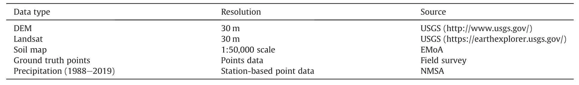
Table 1Utilized data and respective sources.
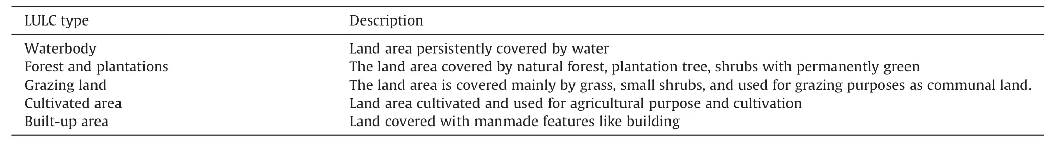
Table 2Description of major land use land covers classes.
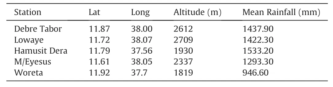
Table 3Summary of meteorological stations in and around Gumara watershed(1988—2019).
In the pre-processing stage,the images were undergone with the removal of atmospheric noise,and other unnecessary topographic obstructions.Then,layer stacking and image sub-setting was conducted to delineate the study site.Land use land cover change analysis has involved a series of analytical steps that require validation.LULC classification was validated based on accuracy assessment techniques using the Kapa Coefficient principle expressed as Equation(1)(Agresti,2007):
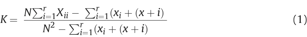
where:ris the number of rows in the matrix,Xiiis the number of observations in rowiand columni(the diagonal elements),x+iandxi+are the marginal totals of row r and columni,respectively,andNis the number of observations.
As per Viera and Garrett(2005),if the total kappa coefficient is above 84% implies that the result of classification agreed with the actual land cover thus,the land use land cover classification is acceptable.Based on this notion,the total kappa coefficient value of the present study was 87%which is above the minimum threshold.
2.2.1.Land use land cover dynamics
After classification,the land use land cover transition and area changes were determined by generating a transition matrix.The landscape transition matrix is a cross-tabulation matrix used to analyze the landscape change between 1988 and 2003,and,1988 and 2019.It provided a clue on how the land uses and land covers were changed to other types of land use land cover.Rate of LULC change quantified based on the equation presented in Equation(2)(Chen et al.,2016;Mohammed et al.,2016):

where:LUDI=the annual rate of change in area for the land use classes.Ua=certain land use class at the time a,Ub=certain landuse class at time b and,T=denotes the length of time from timeaand timeb,whenTis in a unit of the year.
IfLUDI<0,the land cover type is in a state of depletion.The larger the absolute value ofLUDI,the more intensively land has been depleted.LUDI≥0 means just the opposite where the land cover type in a state of expansion(Yirsaw et al.,2016;Zhang et al.,2015).
2.2.1.1.RUSLE model description.An attempt to develop an equation for soil loss was begun in the Corn Belt in about 1940(Wischmeier & Smith,1978).The original version of the model named Universal Soil Loss Equation(USLE)was designed to compute the average rate of soil loss from sheet and rill erosion.It was empirically derived from more than 10,000 plots and years of runoff and soil loss data contributed from 49 locations in the United States(Renard et al.,1997).In 1985,USLE was improved to the Revised Universal Soil Loss Equation(RUSLE)with the same formula but with an improved procedure for computation of determinant factors(Renard et al.,1978,pp.137—167).In this study,the RUSLE model which was developed by Wischmeier and Smith(1978)and modified by Hurni(1985)to the Ethiopian conditions was employed.
Revised Universal Soil Loss Equation(RUSLE)model estimates soil loss by integrating rainfall erosivity(R),soil erodibility(K),slope length and steepness(LS),cover management(C)and conservation practices(P)parameters(Melesse,2011;Renard et al.,1978,pp.137—167).The mathematical relationships of the parameters and factor generation flow chart of the model described in Equation(3)and Fig.2:

where:Aris annual average soil loss(t ha-1y-1),Kis rainfall erosivity(MJ mm h-1ha-1y-1),Ris soil erodibility(t ha-1MJ-1mm-1),Pis land management factor,Cis LULC factor,andLSis terrain parameter.Rainfall erosivity factor(R)is a climate factor that contributes to soil erosion via the detaching power of raindrop and transporting via runoff(Morgan,1995).It is computed by using Equation(4):

where:Ris erosivity power of rainfall andEI iskinetic energy(30 min rainfall intensity)of raindrops(Morgan,2005).ThoughEIdata is not available for the study area,erosivity power of rainfall was derived from mean annual precipitation which was adapted to the Ethiopian case by Hurni(1985)and which was further implemented in many research works(Haregeweyn et al.,2017;Melesse,2011;Meseret & Gangadhara,2017).It is provided in Equation(5)as:

where:pis mean annual precipitation in millimeters.Thus,the mean annual rainfall of five meteorological stations for the period of 1988—2019 was used to drive the R-factor of the Gumara watershed(Table 3).A layer for the R-factor was created by using the ordinary kriging interpolation method(Dobesch,2007)in the ArcGIS environment.
Soil erodibility factor(K)is the rate of soil loss per unit ofRfactor on a unit plot.It measures the soil resistance to detachment and transportation by raindrop and surface runoff(Wischmeier &Smith,1978).Soil texture,organic matter,and permeability of the soil profile are the main physical properties of soil that affect the Kfactor of the soil(Kouli et al.,2008).However,in the conditions where there is the unavailability of detailed data about soil properties,the K-factor was determined based on the soil color property as described in Hurni(1985).Similarly,different studies(Gemechu,2016;Haregeweyn et al.,2017;Meseret&Gangadhara,2017;Tadesse et al.,2017;Tamene et al.,2017;Zerihun et al.,2018)were derived the K-factor from the soil color.Thus,in the present study,a systematic field observation on the soil color was carried and integrated with FAO soil property description to determine the K-factor of the study watershed(Table 4).
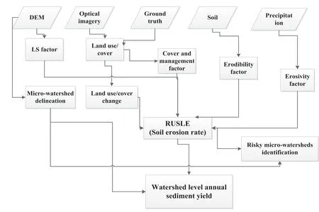
Fig.2.RUSLE model analytical flow chart.

Table 4Soil erodibility factor and associated K-value.
The topographic effect on soil erosion is represented by the slope length and slope steepness(LS-factors).In the RUSLE model,the LS factor is relative to the site conditions with the“standard”slope steepness of 9% and slope length of 22 m plot(Renard et al.,1997;Wischmeier & Smith,1978).An increase in the slope length and slope steepness produces higher overland flow velocities and correspondingly higher erosion(Kouli et al.,2008).In the present study,the LS factor was derived from DEM(SRTM)with 30 m spatial resolution.The equation developed by Moore and Burch(1986)was used to calculate the LS factor(Equation(6)):

where:LSis the slope length and steepens,Ais the product of flow accumulation and cell size(30 m by 30 m),θ is the slope in degrees.
Vegetation cover and management factor(C-factor)is the ratio of soil loss from vegetated plots versus bare soil plots with values between 0 and 1(Robert & Hilborn,2000;Wischmeier & Smith,1978).
C-factor represents the effect of cropping and management practices in agricultural management,and the effect of ground,tree,and grass covers on reducing soil loss in the non-cultivated area(Kouli et al.,2008).It was derived from the 2019 land use land cover map of the watershed(Table 5).
The support practice factor(P-factor)is the ratio of soil loss with a support practice(contouring,strip-cropping,or terracing)in tilling up and down the slope(Wischmeier & Smith,1978).It reflects the impact of specific erosion management practices on erosion rate with a value that ranges between 0 and 1 where the highest values correspond to bare land without any support practices(Blanco & Lal,2008).As there is no well-organized data and consistent soil and water conservation(SWC)practice in the study area,P-value was determined by integrating LULC and slope category(Wischmeier & Smith,1978).Thus,the LULC was grouped as cultivated land and others.Cultivated land was categorized into six slope classes.Each slop class was assigned a P-value which is adopted in most studies(Haregeweyn et al.,2017;Meseret &Gangadhara,2017;Molla & Sisheber,2017;Zerihun et al.,2018)(Table 6).

Table 5Land use land cover and C-factor value of Gumara watershed.
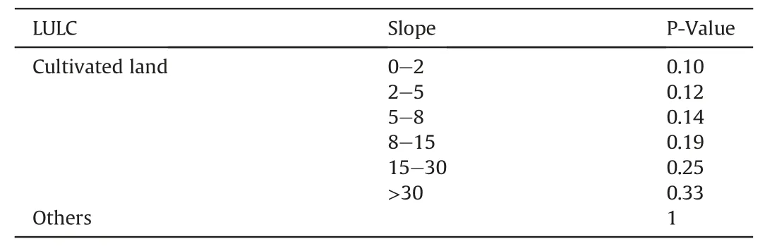
Table 6P-value of Gumara watershed based on the LULC and slope category.
Finally,a watershed level annual sediment yield and sediment delivery ratio was quantified.
Sediment yield is the sediment load at the end of the slope length or the channel outlet of the watershed.It is the sediment load normalized for the drainage area(the net result of erosion and deposition processes)within the watershed(Kouli & Soupios,2008;Vemu & Pinnamaneni,2012).The amount of sediment yield from the watershed was estimated from the sediment delivery ratio(SDR)of the watershed.Even though there are different models used to estimate SDR at the outlet of the watershed a model suggested by Williams and Berndt(1972)was used in this study(Equation(7)).
Frank said, in Arizona, the famers often hired beekeepers to set up beehives near their fields. The bees pollinated the crops and helped them to grow.

where:Syis annual sediment yield tones per year,Ais total gross erosion computed from RUSLE and SDR is sediment delivery ratio,which is the ratio between sediment delivered to the stream and gross sediment produced at the catchment.It was calculated based on Equation(8).

where:SLPis the percentage mean slope of the main channel stream.
3.Results and discussion
3.1.Trends of land use land cover change
Land use land cover change is a proxy for the dynamics of the earth's surface caused by various factors(Hailemariam et al.,2016),thereby indicating the level of human interventions and contribution to soil erosion.Gumara watershed was classified into five major land uses land cover classes,such as cultivated land,forest and plantations,grazing land,and built-up area with high classification accuracy(overall classification accuracy 85% and kappa coefficient 82%)for each period(1988,2003 and 2019).Land use land cover classification maps for the years 1988,2003,and 2019 are given in Fig.3.The spatial distribution of land use land cover classes of the watershed in the years 1988,2003,and 2019 showed that cultivated land and built-up area have increased,while the extent of forest and plantation,and grazing land declined continuously from 1988 till 2019.By the year 1988,forest and plantation,and grazing land have covered 108.58 km2(6.82%),150.67 km2(4.7%)respectively.Their coverages declined to 60.52 km2and 19.61 km2in the year 2019 by-1.42 km2y-1and-2.80 km2y-1rate of change respectively.On the other hand,cultivated land and built-up area coverage have increased by the rate of 0.46 km2y-1and 3.49 km2y-1respectively and covered more than 90%of the watershed by 2019(Table 7 and Fig.3).

Fig.3.LULC map of Gumara watershed in the year(a)1988,(b)2003 and(c)2019.
Cultivated and built-up areas have a high probability to expand to grazing land and forest area(Yang et al.,2017).Hence,in study watershed cultivated land and built-up area have highly expanded to other land use classes implying the degradation of the natural environment and generation of soil erosion.
3.2.Soil loss estimation and risk area mapping
3.2.1.Erosion risk mapping
The spatial distribution of erosion risk of the Gumara watershed was modeled using the RUSLE erosion model.The model integrates five important bio-physical(R,K,LS,C,and P)factors.The R-factor was computed from the mean annual rainfall data of the entire watershed using Equation(3).The mean annual rainfall ranges from 1114.6 to 1431.03 mm and subsequently,the estimated rainfall erosivity ranges from 608.27 to 782.36 MJ mm h-1y-1with an average value of 705.55 MJ mm h-1yr-1.Spatially,erosive power of R-factor is higher in the east and southeastern part of the watershed and decreased to the northern and southern part of the watershed(Fig.4b).
The soil erodibility(K)factor,which was derived from major soil types of the watershed(Fig.5a),ranges from 0 to 0.20 t h-1MJ-1mm-1(Table 4).In the watershed,nearly 60% of the areas have high(>0.2 t h-1MJ-1mm-1)soil erodibility value and less resistance to detachment and transportation from raindrop and surface runoff respectively.The lower K-value coincided with the gentle slope areas and water body whereas the highest erodibility of the soil occurred at a higher elevation with steep slope parts of the watershed(Fig.5b).
3.2.1.1.Slope length and steepness(LS factor).In the soil erosion model(RUSLE),the topographic factor(LS-factor)represents the contribution of slope length and slope steepness for the erosion process.Flow accumulation and the slope condition of the watershed were considered for computing the LS factor(Jain et al.,2001).From the analysis,it was observed that the slope of the area ranges from 0oto nearly 57oand the slope steepness ranges from 0oto 22o(Fig.6 a and b).The slope length of the watershed computed based on the flow accumulation and the cell size of the data(DEM)resulted in 0 up to 333.58(Fig.6c).According to Jain and Kothyari(2000)as the slope length and steepness increase,the velocity of overland flow becomes higher subsequently resulting in a higher rate of erosion.Thus,a higherLSvalue implies a higher erosion probability.
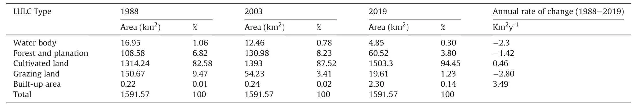
Table 7LULC change and rate of change(1988,2003,and 2019).
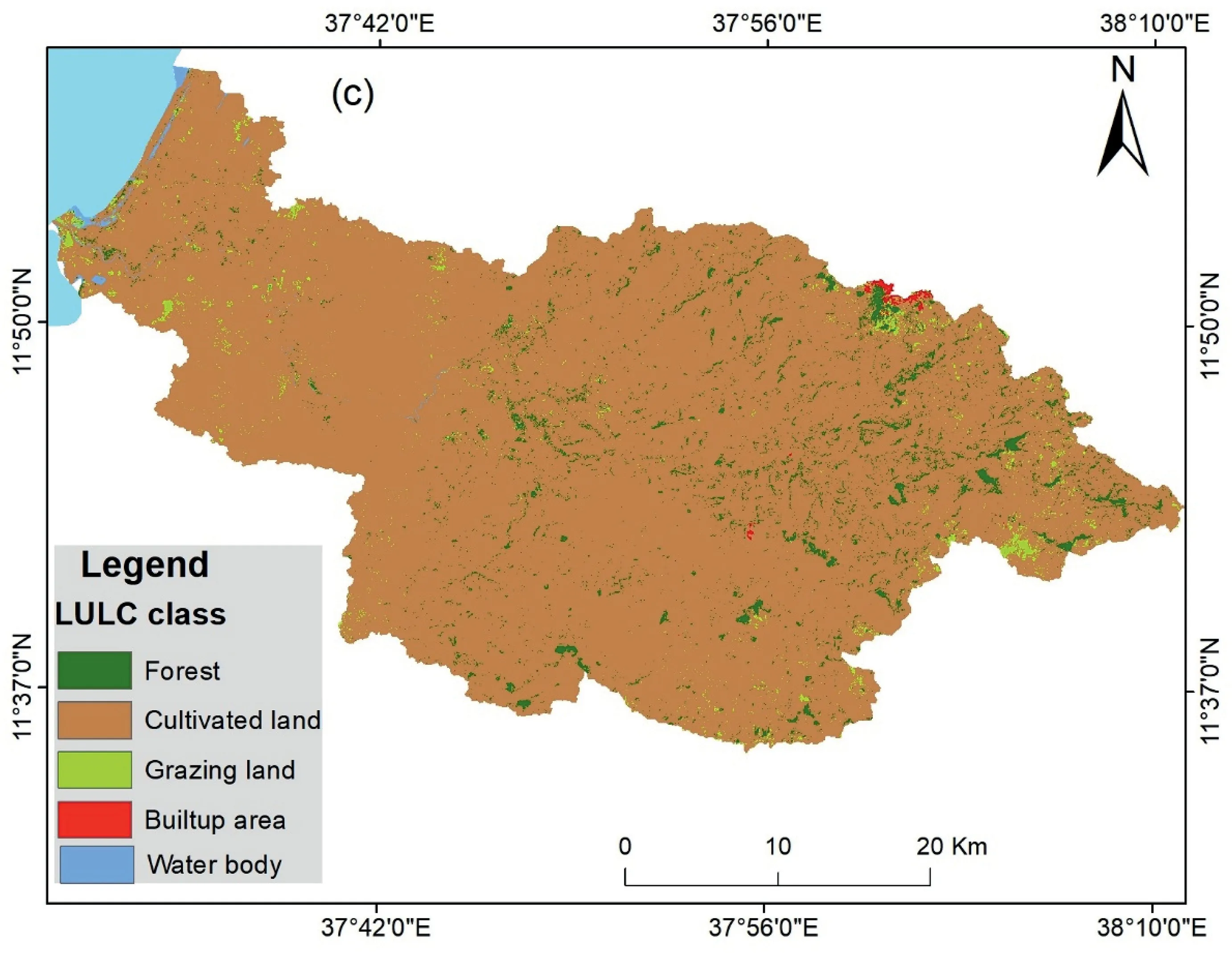
Fig.3.(continued).
3.2.2.Estimated soil loss
The estimated quantity of soil loss in the Gumara watershed was identified and mapped into six soil erosion risk levels viz,slight,moderate,high,very high,severe,and very severe with the consideration of the country's tolerable soil loss rate(5—12 t ha-1y-1)and rate of soil formation(Hurni,1988).
In the study watershed,nearly 14%(207 km2)experienced moderate to very severe soil loss whereas the remaining 86%(1384.0 km2)experienced slight level soil loss(Table 8).On average,annually Gumara watershed has experienced 24.2 t ha-1y-1soil loss rate which causes a significant amount of soil loss from the whole watershed(385,157 t y-1).The high to very severe soil erosion class contributed much because the area is intensively cultivated and experiences relatively high rainfall,and steep slope(Fig.8 and Table 8).Spatially,the risky part of the watershed is positioned to the south,southeast,and north and northeastern part of the watershed where undulated landscapes are dominant towards the foot of Mt.Guna.
3.2.3.Sediment yield
The amount of sediment load at the outlet of the Gumara watershed was estimated from the sediment delivery ratio(SDR)of the watershed.SDR is a measure of sediment transport efficiency that accounts for the amount of sediment transported from the eroding sources to a catchment outlet compared to the total amount of soil detached over the same area(Fernandez et al.,2003).It is well suited to estimate current sediment yield and predict the effect of land treatment and land use land cover changes on the future sediment yield(USAD-SCS,1972).
Though SDR is influenced by the source and texture of sediment,and its proximity,the slope is the major influencing factor that determines the rate of erosion and SDR(USAD-SCS,1972).Hence,the study watershed experiencing an undulating landscape with steep slopes a high amount of sediment delivered from the watershed.The SDR was estimated from the mean channel slope(SPL)as a driving factor based on Equation(8).The mean channel slope factor is 8.82 and the simulated SDR was 1.507 t ha-1y-1.The annual average sediment yield(Sy)of the watershed was 2807.02 t ha-1y-1.
3.3.Prioritization of areas for soil and water conservation
Uniform patterns of soil loss and sediment delivery ratio could not be observed in all parts of the watershed.Note that,such discrepancy is the result of variations in land use land cover and topographic characteristics.Thus,as the severity of erosion risk differs across the watershed,the conservation measures practiced will also vary(Osman & Sauerborn,2016;Gashaw et al.,2017).Thus,identifying soil erosion risky areas and prioritizing according to the erosion severity level is imperative.Though soil erosion is a physical process that follows the landscape configuration,in the study area often administrative boundary is used for mobilizing conservation.Thus,an administrative boundary was used to specify a risky area of the watershed(Fig.9).
Therefore,the northeastern and southeastern part of Gumara watershed mainly Farta(Askuma,Giribi,Mahidre Mariam,Aringo and Kwalihakebeles),Fogera(Gazen Aridafofota and Gura Ambakebeles),and East Este(Witimerakebele),and Dera(Gedame Eyesus and Deriana Wechitkebeles)districts(1Woreda:administrative units which subdivided into(kebeles)smaller administrative unit.woredas)are exposed to much soil losses and calls for interventions.
3.4.Validation
Validating a model(RUSLE)used for estimating a soil loss is essential to confirm the validity of the result and compatibility of the model.However,the absence of measured soil loss and sediment yield data in the study area inhibited validating the result within-situ-based values.Thus,field observations and previous studies conducted in the Upper Blue Nile basin were used to validate the estimated result and effectiveness of the model.
Thus,the estimated soil loss rate and the spatial distribution of erosion classes in the study watershed were comparable with the previous studies(Table 9)and field observation was conducted by a group of experts which confirmed the existence of the problem in the study watershed.
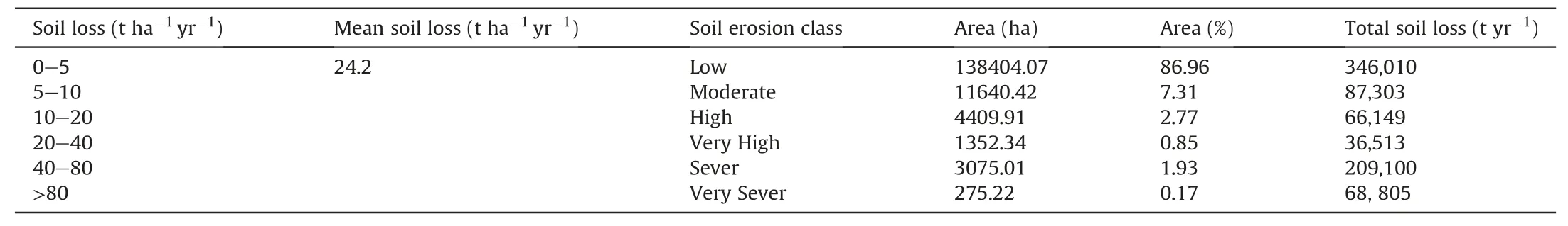
Table 8Soil loss and soil erosion class of Gumara watershed.

Table 9Estimated average soil loss result of previous studies vs the present study.
3.5.Discussion
In the present study,the Gumara watershed has experienced a significant LULC change where forest and plantation area and grazing lands were changed to the cultivated and built-up area with the rate of-1.42 and-2.8 Km2y-1respectively between 1988 and 2019.As Setegn et al.(2009)stated a change in LULC increases the detachability and transport of soil particles and subsequently increases the amount of surface runoff and soil erosion.Though the watershed experienced 24.2 t ha-1year-1mean gross soil loss which is bite higher than the soil loss tolerance rate(5—12 t ha-1yr-1).There are areas with a significant(1861.67 t ha-1yr-1)amount of soil loss.The amount of sediment yield was also higher(2807.02 t ha-1yr-1)in the watershed.Nearly 50% of the watershed experienced average to very severe soil loss and sediment yield which implies the severity of the problem in the watershed.Besides,the sediment transported from the watershed contributes a lot to Lake Tana siltation(sediment load).As Lemma et al.(2019)reported more than 50 Mg ha-1yr-1sediment produced in the watershed was transported to the lake from major tributary rivers(Gumara,Ribb,and others).
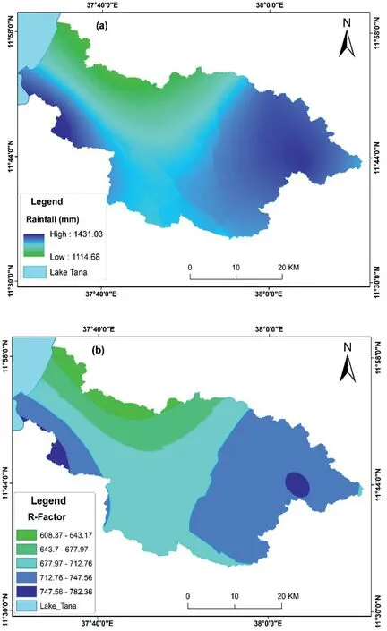
Fig.4.The spatial distribution map of(a)rainfall(b)R-factor of Gumara watershed.
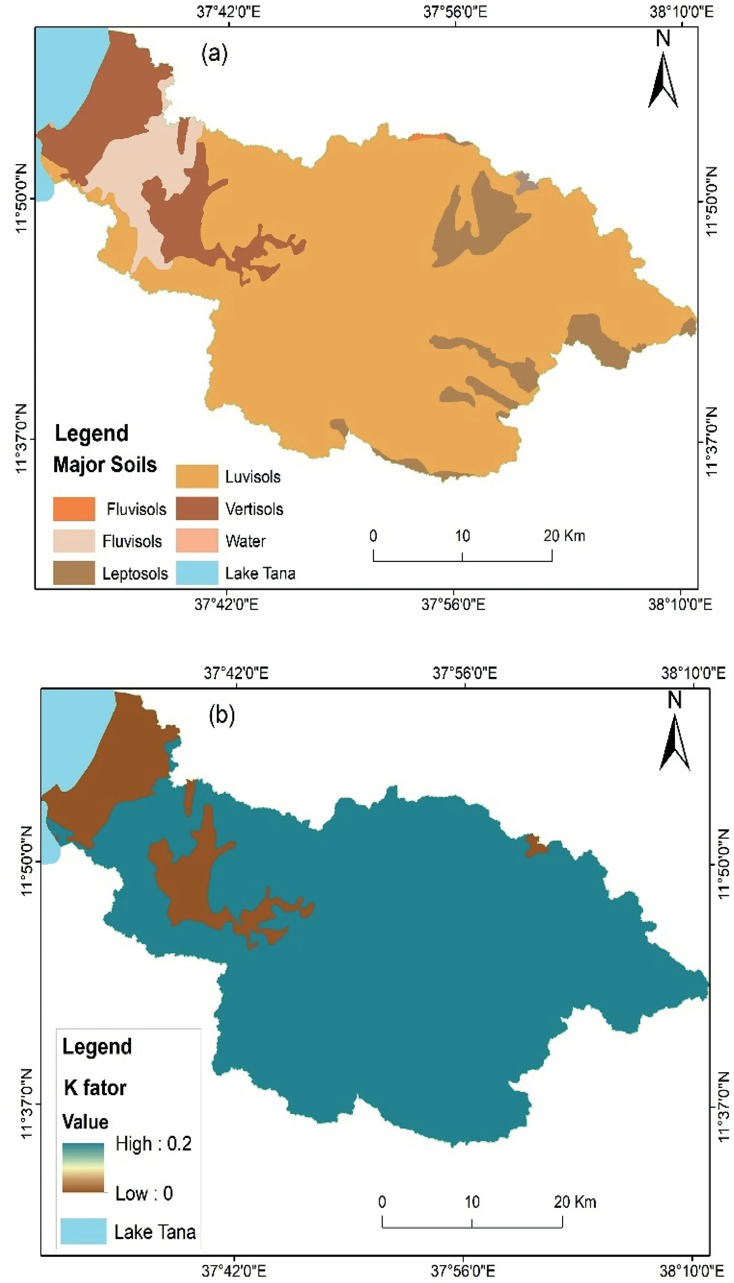
Fig.5.The spatial distribution map of(a)major soil type(b)K-factor of Gumara watershed.

Fig.6.The spatial distribution map of(a)slope and(b)slope steepness(c)Slope length of Gumara.
The average soil loss estimated for Ribb sub-watershed in 2014 was 39.8 t ha-1yr-1(Estifanos,2014).A latter study which was done in 2017 has reported an estimated average soil loss rate of 40 t ha-1yr-1(Meseret & Gangadhara,2017)and in our current study,the watershed has an estimated 43.07 t ha-1yr-1of soil loss.Currently,about 95%of the watershed suffered from a moderate to severe soil loss rate,however,it was 70% in 2016(Meseret & Gangadhara,2017).In this sub-watershed,the rate of soil loss and the area suffered from soil loss showed an increment.This could be due to prevailing changes in LULC and intensive cultivation without proper conservation practices,especially at hill slopes.A hypsometric analysis which shows the surface material stability has been conducted by Asfaw and Workineh(2019)in Gumara and Ribb watershed and reported that the watershed is losing soil materials fast.This calls for the urgency of early conservation.
Similarly,in the Lake Tana sub-basin Balabathina et al.(2019)have reported 41.54 t ha-1yr-1soil loss from the Megech river basin and,Gelagay and Minale(2016)have also estimated 47.4 t ha-1yr-1loss of soil from Koga watershed in 2016,which are higher than the estimated soil loss rate(24.2 t ha-1yr-1)for Gumara watershed.In the Blue Nile basin,Gashaw et al.(2018)estimated 23.7t ha-1yr-1average soil loss rate,and Haregeweyn et al.(2017)also estimated 27.5 t ha-1yr-1average soil loss rate with a gross loss of 473 Mt yr-1.Zerihun et al.(2018)have also reported 49 t ha-1yr-1loss of soil from the Dembecha district.
The estimated soil loss rate result of the study watershed was also within the range of soil loss rate of the Amhara region(between 0.04 and 212 t ha-1yr-1)reported in 1987 and 1988 from sitespecific tests(Desta et al.,2000).It also allied with the soil loss rate(0—300 t ha-1yr-1)estimated for the general Ethiopian highlands(Hurni,1985).Similarly,Setegn et al.(2009)have confirmed that the main stream of the study watershed(Gumara rivers)contributes a large amount of sediment yield production to Lake Tana.This could be attributed to the steeper and longer slope of the landscape,continuous tillage of the same land without fallowing,and lack of proper conservation activities.Besides,change in land use from natural cover to cultivation and built-up plays a significant role in intensifying the rate of soil erosion and sediment yield.Most studies(Balabathina et al.,2019;Melesse,2011;Meseret &Gangadhara,2017;Molla & Sisheber,2017;Mutua et al.,2006)confirmed that land use land cover change and improper soil and water management practices worsen the problem of soil erosion.
4.Conclusion
Gumara watershed which is drained by the major tributary of Lake Tana has experienced high erosion and sediment yield.If-not curved,Lake Tana,Grand Ethiopian Renaissance Dam(GERD),and other micro-irrigation dams would be at risk of sedimentation,nutrient pollution,and loss of water quality and agricultural productivity.Thus,estimating and prioritizing areas according to the level of soil erosion risk is imperative.Hence,this study attempted to estimate soil loss and sediment yield in Gumara watershed.The result showed that the watershed losses on average 24.2 t ha-1yr.-1soil annually and 385,157.52 t ha-1yr-1soil from the entire watershed.The estimated sediment yield was about 2807.02 t ha-1yr-1and nearly 50%of the watershed experienced high soil erosion risk.Though,a large amount of soil is currently leaving from the watershed,prioritizing areas according to the level of soil erosion risk will ease efforts in addressing the problem properly.Thus,Gumara watershed particularly the upper part of the watershed where Farta,Fogera,and East Este districts required intensive soil and water conservation practices.This is very important to save Lake Tana and GERD from siltation.More importantly,appropriate conservation practices should be placed to enhance soil productivity and respective food security of local smallholder farmers.

Fig.6.(continued).

Fig.7.The spatial distribution map of(a)C-factor and(b)P-factor of Gumara watershed.

Fig.8.RUSLE model estimated soil loss of Gumara watersheds.

Fig.9.Soil erosion risky area map.
Declaration of competing interest
The authors declare that there is no competing interest.
Acknowledgment
The authors greatly acknowledge ANRS BoFED and MoA for providing soil data;Ethiopian Metrological Agency for providing metrological data and the South Gonder Zone Agricultural office for their cooperation in collecting field data.We thankful Mr.Mulugeta Neka(Ass.Professor)for his proof read on the revised manuscript.We would also like to express our deepest gratitude to anonymous editors and reviewers for their valuable comments for the betterment of this paper.
杂志排行

International Soil and Water Conservation Research的其它文章
- GUIDE FOR AUTHORS
- A detailed reconstruction of changes in the factors and parameters of soil erosion over the past 250 years in the forest zone of European Russia(Moscow region)
- Changes in hydrologic components from a mid-sized plots induced by rill erosion due to cyanobacterization
- Organic manure input and straw cover improved the community structure of nitrogen cycle function microorganism driven by water erosion
- Soil properties characterization for land-use planning and soil management in watersheds under family farming
- Land surface roughness impacted by typical vegetation restoration projects on aeolian sandy lands in the Yarlung Zangbo River valley,southern Tibetan plateau