Monthly composites from Sentinel-1 and Sentinel-2 images for regional major crop mapping with Google Earth Engine
2021-06-02LUOChongLIUHuanjunLUpingLIUZhengrongKONGFanchangZHANGXinle
LUO Chong,LIU Huan-jun, ,LU Lü-ping,LIU Zheng-rong,KONG Fan-chang,ZHANG Xin-le
1 Northeast Institute of Geography and Agroecology,Chinese Academy of Sciences,Changchun 130102,P.R.China
2 School of Pubilc Adminstration and Law,Northeast Agricultural University,Harbin 150030,P.R.China
Abstract Rapid and accurate access to large-scale,high-resolution crop-type distribution maps is important for agricultural management and sustainable agricultural development.Due to the limitations of remote sensing image quality and data processing capabilities,large-scale crop classification is still challenging.This study aimed to map the distribution of crops in Heilongjiang Province using Google Earth Engine (GEE) and Sentinel-1 and Sentinel-2 images.We obtained Sentinel-1 and Sentinel-2 images from all the covered study areas in the critical period for crop growth in 2018 (May to September),combined monthly composite images of reflectance bands,vegetation indices and polarization bands as input features,and then performed crop classification using a Random Forest (RF) classifier.The results show that the Sentinel-1 and Sentinel-2 monthly composite images combined with the RF classifier can accurately generate the crop distribution map of the study area,and the overall accuracy (OA) reached 89.75%.Through experiments,we also found that the classification performance using time-series images is significantly better than that using single-period images.Compared with the use of traditional bands only (i.e.,the visible and near-infrared bands),the addition of shortwave infrared bands can improve the accuracy of crop classification most significantly,followed by the addition of red-edge bands.Adding common vegetation indices and Sentinel-1 data to the crop classification improved the overall classification accuracy and the OA by 0.2 and 0.6%,respectively,compared to using only the Sentinel-2 reflectance bands.The analysis of timeliness revealed that when the July image is available,the increase in the accuracy of crop classification is the highest.When the Sentinel-1 and Sentinel-2 images for May,June,and July are available,an OA greater than 80% can be achieved.The results of this study are applicable to large-scale,high-resolution crop classification and provide key technologies for remote sensing-based crop classification in small-scale agricultural areas.
Keywords:Sentinel-1,Sentinel-2,monthly composites,crop mapping,Google Earth Engine
1.Introduction
The United Nations predicts that the world population will increase to 11.2 billion in 2100,which will inevitably lead to an increase in the human demand for food (Belgiu and Csillik 2018).In this context,there is an urgent need to optimize crop distributions and to strengthen the intensification of agriculture to ensure global food and nutrition security (Daviset al.2017;Rockströmet al.2017).The accurate mapping of regional crop types is the basis of crop distribution optimization and the intensive development of agriculture,which are essential for food macro regulation and the development of scientific agricultural management and practices (Youet al.2009;Conradet al.2010).The use of remote sensing techniques to map regional crop types has been shown to be feasible in many parts of the world(Waldhoffet al.2017;Liuet al.2019).
The use of remote sensing for crop growth,disaster monitoring and crop yield estimation is very common (Menget al.2019;Luoet al.2020).However,for most applications,it is necessary to distinguish between crop types to improve the monitoring accuracy.Unfortunately,few large-scale,high-resolution crop-type maps are available (Griffithset al.2019).Current crop-type products typically only cover some developed countries.For example,the Cropland Data Layer (CDL),which has been produced by the USDA National Agricultural Statistics Service since 2008,covers the entire United States using multiple sources of data (e.g.,Landsat-8 and Sentinel-2);while supervised classification methods provide government agencies and farmers with crop plots which have highly accurate plot sizes (Boryanet al.2011;Belgiu and Csillik 2018).In 2012,optical maps and radar images were used to produce crop classification maps entirely covering Canada (Davidsonet al.2017);in addition,some countries in Europe have also produced national-scale crop classification maps with the support of the Sentinel agricultural project.
Although large-scale farming is a trend in world agricultural development,smallholder farming is still the main agricultural management method in most developing countries,such as China and India (Altieriet al.2012).Small planting plots are one of the main features of smallholder farming;thus,it is difficult to classify crops in these areas.Furthermore,because these developing countries often face greater food security problems,it is important to understand the distributions of crop types in these countries.However,due to technical limitations,developing countries usually use sample survey methods to understand the distribution of crops in a region;but such methods require significant labor resources and other resources,and the accuracy and timeliness of the data cannot be guaranteed.Moderate resolution imaging spectroradiometer (MODIS) images are commonly used in large-scale crop classification tasks,but the 500-m resolution of such images causes large errors in areas with small plots;thus,remote sensing-based crop classification on the regional scale with a medium-high spatial resolution is necessary.
Many scholars have studied small-scale,high-resolution crop-type mapping (Kussulet al.2016,2017;Liuet al.2019;Haoet al.2020).Due to differences in local agricultural management,crop varieties and other environmental factors,a given crop type may exhibit different spectral characteristics (Griffithset al.2019;Zhanget al.2019).Therefore,the use of multitemporal remote sensing data to obtain more detailed spectral features of crops has become key to crop-type mapping.Many recent studies have used multitemporal remote sensing data for croptype mapping.For example,Vuoloet al.(2018) found that using multitemporal Sentinel-2 data and Random Forest(RF) models can significantly improve crop classification accuracy.Belgiu and Csillik (2018) used Sentinel-2 timeseries data to compare the time-weighted dynamic time warping classification method with the accuracy differences of RFs.Ingladaet al.(2016) successfully mapped crop types using optical images and synthetic aperture radar (SAR)data.However,these studies usually have narrow scopes,and large-scale,high spatial-resolution crop classification studies are still relatively rare.
The successful launch of Sentinel-2B in 2017 reduced the return visit period of Sentinel-2 to 5 days,which has made it possible to acquire sufficient time series of optical images (Chenet al.2017).The C-band of Sentinel-1 can penetrate clouds;thus,in Heilongjiang Province,China,during the hot and rainy period,which is the critical period of crop growth,auxiliary information can be provided.Google Earth Engine (GEE) is a cloud-based platform designed to process satellite imagery and other terrestrial data.The GEE platform stores Petabyte-level processing-ready data,enabling researchers to quickly process millions of images in parallel,and thereby greatly improving the efficiency of image analyses.
Equal-interval synthesis has become a feasible solution for balancing the spatial and temporal resolutions of largescale remote sensing images.Such methods,including the maximum normalized difference vegetation index (NDVI)synthesis method,were originally designed to reduce cloud effects for low-and medium-resolution sensors (e.g.,advanced very high resolution radiometer (AVHRR) and MODIS) (Cihlaret al.1994;Wolfeet al.1998).Calculating the median reflectance or index median of a time-series image is a commonly used pixel synthesis method (Potapovet al.2012).Equal-interval synthesis can be used to obtain cloud-free composite images of a large-scale regional time series,and it can provide data support for classification tasks and other work.Relevant research has been used to study monthly synthetic data for wetland classification(Mahdianpariet al.2019).
The research objectives of this paper are:1) to evaluate the potential of crop mapping at a regional scale using monthly composite images;2) to evaluate the impact of including shortwave infrared (SWIR) bands,red-edge bands,common vegetation indices and the backscattering coefficient on crop classification;3) to evaluate the timeliness of crop classification;and 4) to map the spatial distributions of crops at a regional scale.
2.Materials and methods
2.1.Study area
The study area is located in Heilongjiang Province in the northeastern part of China,from 43°26´–53°33´N and 121°11´–135°05´E (Fig.1).The total land area of Heilongjiang Province is 473 000 square kilometers,of which,the cultivated land area is 119 000 square kilometers,accounting for approximately 25% of the total land area.The area is characterized by a cold temperate and temperate continental monsoon climate,and the precipitation shows obvious monsoon characteristics.Summer precipitation is abundant,the winter is dry,and the annual average precipitation is 360–830 mm (Jianget al.2018).The main crops in the region are corn,soybeans and rice.The planting area of these three crops accounts for more than 95% of the total planted area (Huet al.2017).
Due to the climate,the planting patterns in the region encompass all seasons.The crop calendar for the main crop types of corn,soybeans,rice and wheat in the region(Table 1) shows that the key growth periods of the main crops in Heilongjiang Province are from May to September;thus,the study period is set to May–September 2018 to reduce data redundancy.
2.2.Reference data
In this paper,the cultivated crops in Heilongjiang Province are divided into five categories:soybeans,corn,rice,other crops and fallow land.Each year,the agricultural insurance company collects data on the types of crops in the insured plots for future management.We obtained the data from 246 189 parcels of insured land in Heilongjiang Province in 2018 from the agricultural insurance company,randomly selected 3 209 plots,and used ArcGIS 10.2 to convert the surface into points to reduce the number of calculations required.The crop types mainly include corn,soybeans,rice and other crops,and there are 1 390 corn samples,712 soybean samples,846 rice samples,and 261 other crop samples.In addition,due to the 2018 rice–fallow policy in Heilongjiang Province,some cultivated lands were not planted.To identify fallow land,we obtained 35 plots of fallow land by field sampling so that a total of 3 244 samples in this study were used to train and verify the sample.The selected samples were confirmed on-site from July to August 2018 (Fig.1),and the ratios of sample points of different crop types are roughly the same as the area ratios between the actual crop types in the study area.Subsequently,we randomly selected 70% of the samples as training samples and 30% of the samples as verification samples.
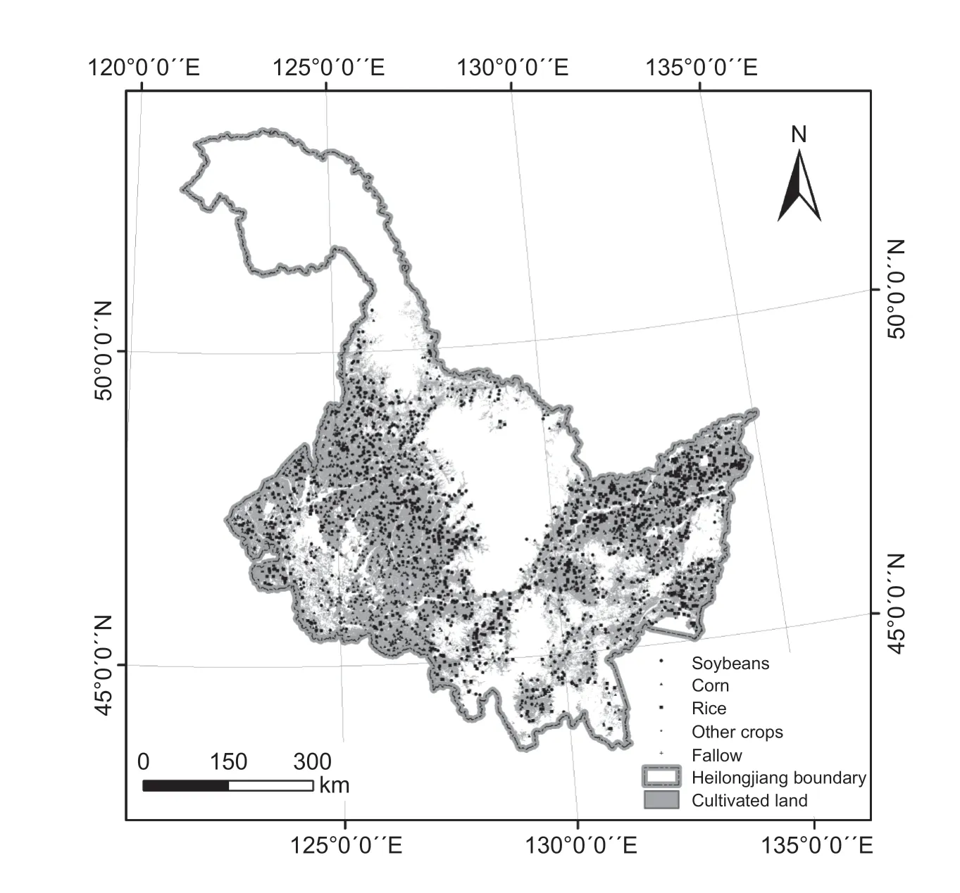
Fig.1 Overview of Heilongjiang Province,China.
2.3.Sentinel-2 imagery and preprocessing
In this study,5 532 Sentinel-2 images (Level-1C) covering Heilongjiang Province from May 1,2018,to September 30,2018,were selected for crop classification.The total number of observations for each pixel in different regions during the study period is shown in Fig.2-A.The average number of observations per pixel for Sentinel-2 is 65,the minimum number of observations is 27,and the maximum number of observations is 343.The warmer the color in Fig.2-A,the higher the frequency of observation.
We built a function in GEE using the quality assessment(QA60) band detection and masking of clouds provided in the metadata to obtain a cloudless set of Sentinel-2 images(Fig.2-B) and divided all the band values by 10 000 to obtain the band reflectance values.The number of effective observations for each pixel in different regions of Sentinel-2 during the study period is shown in Fig.2-B.The average effective number of observations per pixel for Sentinel-2 is 30,the minimum number of observations is 2,and the maximum number of observations is 199.
In this article,Sentinel-2 was selected for classification for all 10-and 20-m resolution bands,including blue,green,red,near-infrared (NIR),red-edge 1,red-edge 2,red-edge 3,rededge 4,SWIR1,and SWIR2.The first four bands of 10-m resolution are the bands normally used for classification.The red-edge bands are related to the chlorophyll content of the crops.The SWIR bands are related to the water content of vegetation.These bands have been proven to have the ability to distinguish crop types (Chenet al.2005;Clevers and Gitelson 2013).In addition,we used several commonly used indices to assist in the classification,including the normalized vegetation index (NDVI) (Tucker 1979),the enhanced vegetation index (EVI) (Hueteet al.2002),the land surface water index (LSWI) (Xiaoet al.2002) and the green chlorophyll vegetation index (GCVI) (Gitelsonet al.1996),which have the following formulas:
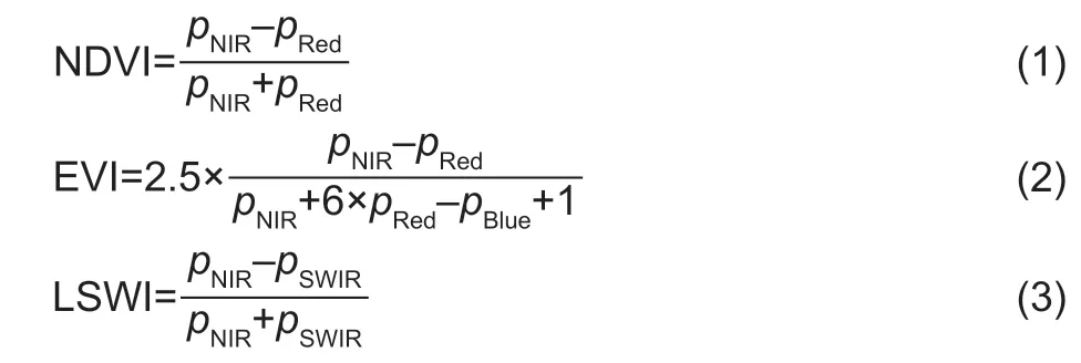

Table 1 Heilongjiang main crop calendar1)
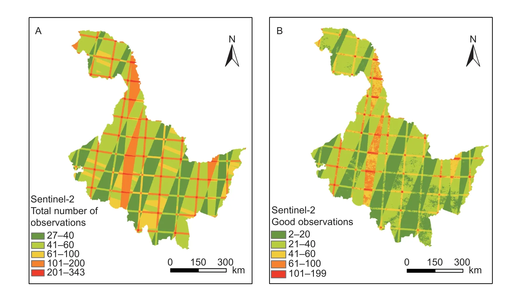
Fig.2 Number of observations from Sentinel-2 in Heilongjiang Province from May 1 to September 30,2018.A,total number of observations.B,good observations.

wherepBlue,pGreen,pRed,pNIRandpSWIRare the surface reflectance values of Band 2,Band 3,Band 4,Band 8 and Band 11,respectively,in the Sentinel-2 Level-1C products.
2.4.Sentinel-1 imagery and preprocessing
In this study,all images from Heilongjiang Province with VV (single polarization,vertical emission/vertical reception)and VH (double polarization,vertical emission/horizontal reception) polarization from May 1,2018,to September 30,2018,were selected.In total,475 Sentinel-1 dualpolarized C-band SAR instrument images were used for crop classification,and these data were archived in GEE in the form of Sentinel-1 SAR Ground Range Detected (GRD) datasets.All images were preprocessed by the Sentinel-1 toolbox using the following steps:(1) thermal noise removal;(2) radiometric calibration;(3) terrain correction using the Shuttle Radar Terrain Mission(SRTM) or Advanced Spaceborne Thermal Emissions and Reflection Radiometer (ASTER) digital elevation model(DEM);and (4) conversion to a backscattering coefficient(σ0) in decibels (dB).
Fig.3 shows the number of Sentinel-1 observations for each pixel from May 1 to September 31,2018.Sentinel-1 has an average of 20 observations,a minimum of nine observations,and a maximum of 39 observations.Finally,we used the Refined Lee Filter to filter the backscattering time series to remove speckle noise in the Sentinel-1 dataset (Leeet al.2008;Yommyet al.2015).For this classification task,this paper selected the VV polarization and VH polarization of Sentinel-1,which are commonly used in land use classification tasks.
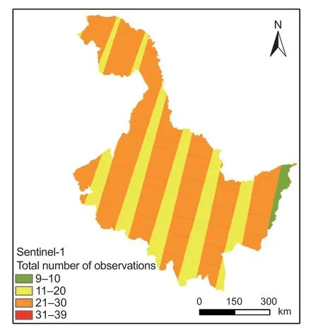
Fig.3 Total number of observations from Sentinel-1 in Heilongjiang Province,China from May 1 to September 30,2018.
2.5.Auxiliary data
Many studies have shown that remote sensing images used for crop classification may be based on land that is not cultivated,such as woodlands,grasslands,and wetlands(Griffithset al.2019).To avoid this error,a digital“cultivated land”mask at a 30-m spatial resolution (Northeast Institute of Geography and Agroecology,Chinese Academy of Sciences,unpublished data) was superimposed onto the crop map to help select crop sampling locations.
2.6.Image compositing
In the time-series analysis,to reduce the uncertainty in the number of effective pixels caused by the rainy season and the satellite revisit period,the time series of the image is fully utilized,and the statistical indicators of the time series are usually used to distinguish different land types (Mahdianpariet al.2019;Tianet al.2019).The median of the time-series images is a commonly used statistical indicator that has been successfully applied in land use classification (Liuet al.2019;Mahdianpariet al.2019;Tianet al.2019).Considering the data availability,the complexity of the calculation and the classification accuracy,the monthly(30-day) synthetic data were selected as the input image.Therefore,in this paper,the monthly image median was selected as a statistical indicator of the time-series images.
We wrote code on GEE for image recombination,which produced a cloudless composite image of the Sentinel-2 reflectance band and vegetation index for each month from May to September in the Heilongjiang crop-growing season,including three visible light bands and one NIR band,four red-edge bands,two SWIR bands and the composite median of the four vegetation indices (Fig.4-A).We used the same method to address the two kinds of SAR polarization characteristics (VV polarization and VH polarization) of the Sentinel-1 images,and obtained the VV polarization and VH of the Sentinel-1 images for every month from May to September in the Heilongjiang crop-growing season and the composite median of polarization (Fig.4-B).
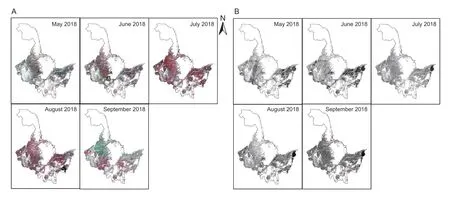
Fig.4 Monthly image composite results from May to September.A,Sentinel-2.B,Sentinel-1.
2.7.Random Forest classifier
RF classifier is a classification technique that uses multiple trees to train and predict samples.Because it is more accurate than the traditional maximum likelihood and decision tree classification methods,the algorithm is very popular in the field of remote sensing and has been successfully applied in many recent classification studies(Liaw and Wiener 2002;Díaz-Uriarte and De Andres 2006).This article uses the RF classifier included in GEE to classify the values of the decision trees and variables in each node.In this study,we set the number of trees to 300 and the other parameters to the default values.
2.8.Experimental design
In order to evaluate the different band reflectance values,vegetation indices,backscattering coefficient on crop classification,and the timeliness of crop classification,we designed the following experiments.First,we divided the bands of Sentinel-2 into three categories:traditional bands(visible bands and NIR band),red-edge bands and SWIR bands.To conduct the above evaluations,we designed the following seven experimental protocols.
Scheme 1:only the traditional bands (visible bands and NIR band) were used for classification.
Scheme 2:the traditional bands and SWIR bands were used for classification.
Scheme 3:the traditional bands and red-edge bands were used for classification.
Scheme 4:the traditional bands,SWIR bands and rededge bands were used for classification.
Scheme 5:the traditional bands,SWIR bands,rededge bands and common vegetation indices were used for classification.
And so we have Bobber s Day. The boys buy their stepfather a new toy they can all play with. The Bobber grills2 steaks. And I am awed3 by our great fortune that the Bobber earned his way into this family with such grace that it now seems he was always there.
Scheme 6:only the SAR data were used for classification.
Scheme 7:all the optical and SAR data were used for classification.
To test the differences in classification performance of the imaged crops during a single period,we distributed the images by month for classification to create a total of five groups.To test the timeliness of crop classification,we used a distribution of images from May to the specified month for crop classification to create a total of four groups.Therefore,this experiment involved 63 tests.
2.9.Accuracy verification
In this paper,five evaluation indices are used.The overall accuracy (OA),Kappa coefficient,user’s accuracy (UA),producer’s accuracy (PA),and F1 score were calculated using test points that were not included in model training(Cohen 1960;Congalton 1991).The OA is the ratio of the number of correctly classified cells to the total number of cells.The Kappa coefficient represents the proportion of errors that are reduced by classification and completely random classification.The PA is the conditional probability that the classification result of a given place on the classification map is consistent with any random sample in the test data.The UA involves taking a random sample with the same conditional probability as the actual type of ground from the classification results.The F1 score is the harmonic mean of the UA and PA (Goutte and Gaussier 2005).Their formulas are listed below:
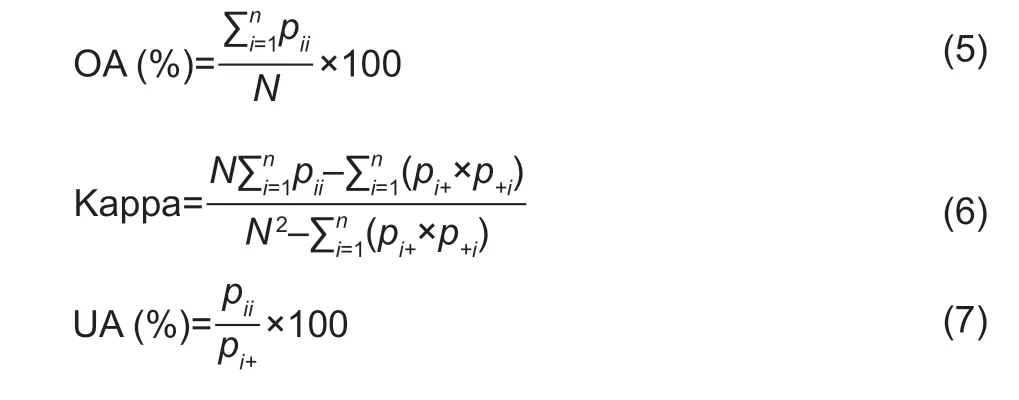

wherenis the total number of columns of the confusion matrix;Piiis the number of correct classifications of the upper crop-type sample in theith row andith column of the confusion matrix,Pi+andP+iare the total number of crop-type samples in rowiand columni,andNis the total number of samples used for verification.
3.Results
3.1.Time-series profiles of the main crops
Fig.5 shows the median time series of the different bands for the five types of training sites in Heilongjiang Province in 2018 to illustrate the potential contributions of the different bands for crop classification.As shown in Fig.5,the differences between the SWIR1,SWIR2,LSWI,VH and VV bands for rice and other crops types were the largest in May and June.The two main crops,corn and soybeans,differed the most in the red-edge 2,red-edge 3,NIR,rededge 4,SWIR 1 and SWIR 2 bands in July and August.The two types of fallow land and other types of crops differed most from the other types in the NDVI,EVI,and GCVI in July and August.
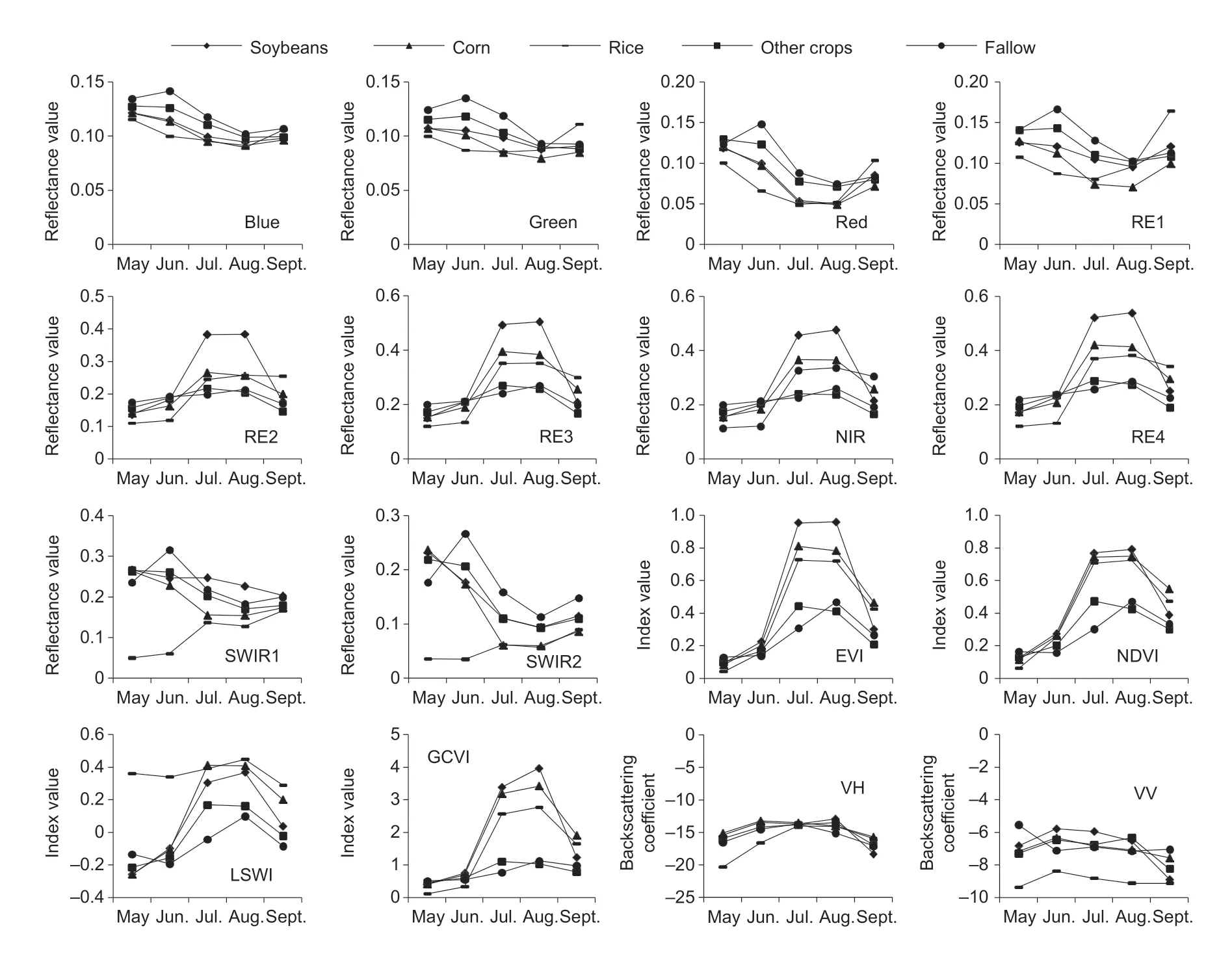
Fig.5 Median band reflectivity,vegetation indices and backscattering coefficients for the monthly composites from all the training points.Blue,blue band;Green,green band;Red,red band;RE1,red-edge 1 band;RE2,red-edge 2 band;RE3,red-edge 3 band;NIR,near infrared band;RE4,red-edge 4 band;SWIR 1,shortwave infrared 1;SWIR 2,shortwave infrared 2;EVI,enhanced vegetation index;NDVI,normalized vegetation index;LSWI,land surface water index;GCVI,green chlorophyll vegetation index;VH,VH polarization;VV,VV polarization.
3.2.Accuracy verification
Crop classification of the time-series imagesHere,we use time-series images from the different schemes for crop classification.As shown in Fig.6,the classification accuracies of Scheme 2 and Scheme 3 are higher than that of Scheme 1,which proves that adding the SWIR bands and the red-edge bands when using time-series images for crop classification can improve the crop classification accuracy.The classification accuracy of Scheme 2 is higher than that of Scheme 3,which proves that the SWIR bands were more useful than the red-edge bands when using time-series images for crop classification.Adding the common vegetation indices and SAR data can improve the classification accuracy,but this improvement is small (the difference between the lowest and the highest accuracies is 0.6%).When using the time-series images for crop classification,Scheme 7 had the best classification performance (89.74% and 0.85),and Scheme 6 had the worst classification performance (71.12% and 0.56).
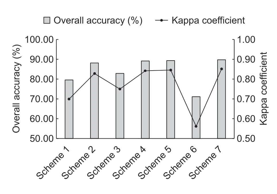
Fig.6 Classification accuracy of the different schemes of time-series images.
3.3.Analysis of the effectiveness of crop classification
For this analysis,we designed experiments to test the variations in the crop classification accuracy over time under different schemes.To achieve this goal,we set May as the fixed start date and each month from May to September as the end dates.For each end date,the time-series data used for classification spans from May to a specific end date.Fig.7 shows the change in the classification accuracy over time for the different schemes,and Fig.8 shows the rate of change in the classification accuracy over time for the different schemes.The schemes including the SWIR bands or red-edge bands (Scheme 2,Scheme 3,Scheme 4,Scheme 5 and Scheme 7)have similar trends in their changes in accuracy,and the classification accuracy increases from June to July by more than 15%.Schemes including SWIR bands can achieve an OA of more than 80% in July,and these schemes are more advantageous than the other schemes,mainly because SWIR bands from July can distinguish between the two main crops:corn and soybeans.The classification accuracy of Scheme 6 has a special trend over time.The classification accuracy increases from May to June by more than 15%,mainly because the VH and VV polarizations in June can distinguish between rice and the other types.Scheme 1 has the largest rate of change in the classification accuracy during the periods from July to August and from August to September.
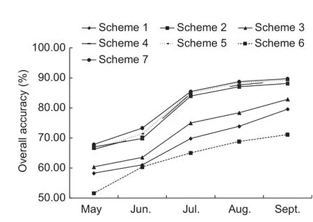
Fig.7 Classification accuracy as a function of the different schemes.
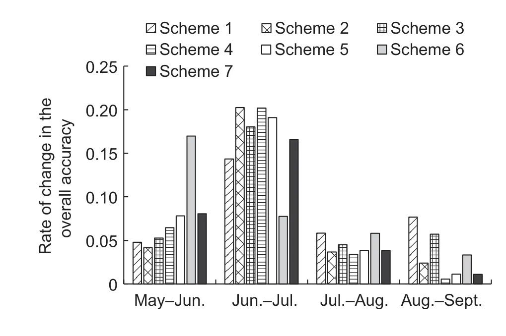
Fig.8 The rate of change in the classification accuracy under the different schemes.
3.4.Classification results
We used the most accurate scheme (Scheme 7),which has the highest OA and Kappa coefficient (Fig.9),to map the crop distribution in Heilongjiang Province with the GEE platform.Of the distributions of the three main crops in Heilongjiang Province (corn,soybeans and rice),corn is mainly distributed in the southern part of Heilongjiang Province,soybeans are mainly distributed in the northwest of Heilongjiang Province,and rice is mainly distributed in the Sanjiang Plain.Through remote sensing monitoring,the areas planted with corn,soybeans and rice in Heilongjiang Province in 2018 were 8 496 583,3 947 725 and 4 848 971 ha,respectively.
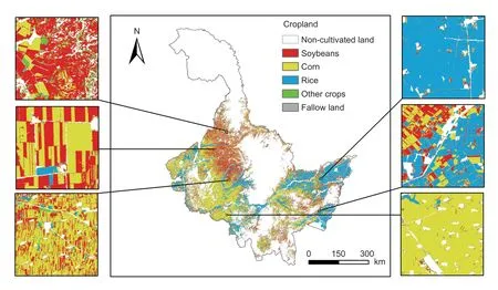
Fig.9 Crop classification map of Heilongjiang Province,China.
4.Discussion
The very large amount of data,high computing power and various machine learning algorithms available in the GEE platform are key to this research.For example,for the traditional crop classification process,images must be downloaded first and then various preprocessing steps must be performed.In this study,we directly included more than 5 000 Sentinel-2 Level 1-C data and more than 400 Sentinel-1 radar data from GEE for crop classification.If the traditional method was used,it might have taken several or even dozens of days,which is unacceptable in terms of both time delay and labor.In GEE,however,this process took only a few seconds.We spent most of our time writing the code that was used to process the composite images and then used RF classifiers for crop classification;the entire process from running the program to exporting the classification results took approximately 8 h.Moreover,the classification of different schemes can be processed in parallel,which is a great advantage over traditional methods.
Balancing the temporal and spatial resolutions of satellite images is challenging in large-scale crop classification studies.Our research shows that it is feasible to use equal-synthesis images for crop classification.Our results show that the highest accuracy (89.74% and 0.85)for crop classification using time-series images is much higher than the highest accuracy (76.59% and 0.66) using single-period images.This finding proves that time-series information has a great influence on the accuracy of crop classification.The Sentinel-1 and Sentinel-2 combination of time-series images (Scheme 7) achieved the highest classification accuracy (89.74% and 0.85),which was slightly higher than the classification accuracy using only Sentinel-2 time-series data (Scheme 5) (89.34% and 0.85) and much higher than the classification accuracy(71.12% and 0.56) using only Sentinel-1 time-series data(Scheme 6).This finding indicates that the addition of Sentinel-1 radar data can improve the accuracy of crop classification,which is consistent with previous research results;however,the degree of improvement is small (the OA is less than 1%).Because the use of Sentinel-2 images in this study achieved high precision,it would be difficult to further improve the accuracy.The classification accuracy using only Sentinel-1 data is disappointing,and all types of classification results had low accuracies compared to those from the other schemes (Fig.10-A).The classification results using Sentinel-1 images in areas with large plots are not significantly different from those using Sentinel-2 images (Fig.10-B).However,the classification results using Sentinel-1 images in areas with small plots are quite different from the results using Sentinel-2 image classification;the classification result of Sentinel-1 does not distinguish the boundaries of the parcels well.Although this study performed Lee filtering on the Sentinel-1 images,the noise in these images still affected the classification accuracy.
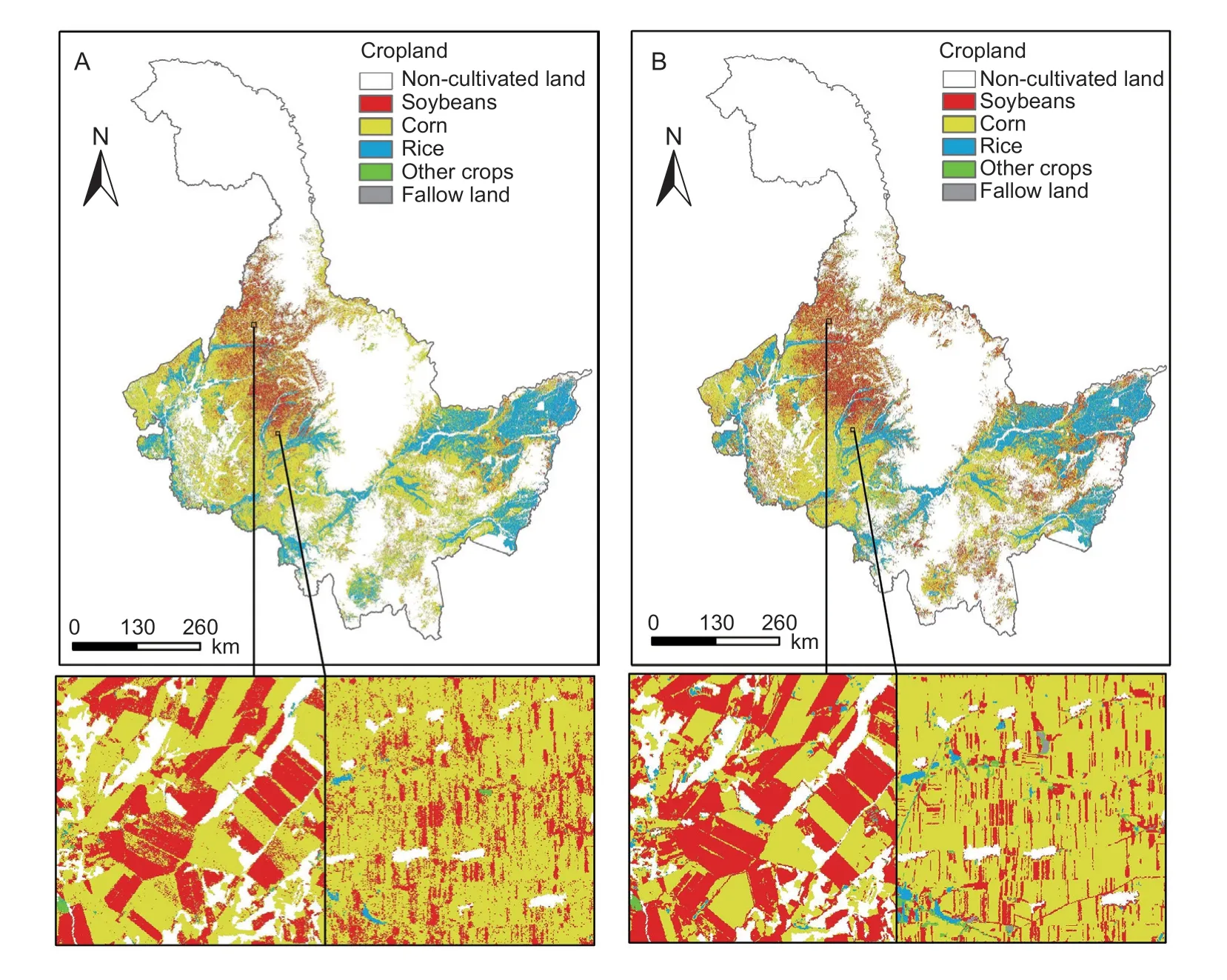
Fig.10 Comparison of the crop classification results when using Sentinel-1 and Sentinel-2.A,Sentinel-1.B,Sentinel-2.
In addition,we analyzed the effects of adding red-edge bands,SWIR bands,and common vegetation indices on classification performance.The soybean classification accuracy is poor when only traditional bands are used for classification (F1 score=71.79%).Adding red-edge bands to the traditional band can improve the classification accuracy of soybeans (F1 score=78.84%),as can adding SWIR bands (F1 score=84.97%) (Fig.11).This finding indicates that both the red-edge bands and the SWIR bands have the ability to identify soybeans,but the SWIR bands have a stronger recognition ability (Caiet al.2018).Furthermore,the addition of the SWIR bands can greatly improve the accuracy of corn classification and slightly improve the accuracy of rice classification,possibly because the SWIR bands are sensitive to moisture,and rice cultivation is inseparable from water (Singhaet al.2019).Adding common vegetation indices can improve the accuracy of fallow land classification,possibly because the changes in the vegetation indices for fallow land are very different from the changes in the vegetation indices for crops.
Early access to crop classification maps can be beneficial.Crop classification data are required for agricultural monitoring,such as growth monitoring and crop estimation.As shown in Fig.12,the addition of the composite images from July can greatly improve the classification accuracy of soybeans and increase the classification accuracy of corn and rice to an acceptable level (F1 score>80%).The classification accuracy of other crops and fallow land with smaller distribution areas is also improved.Our research shows that in Heilongjiang Province in northeastern China,the combination of Sentinel-1 and Sentinel-2 data can be used to obtain crop classification maps with an OA greater than 80% as soon as the May,June,and July images are available.This finding will undoubtedly improve the convenience of subsequent agricultural management projects.Accurate crop classification maps available in early August will facilitate subsequent applications in the field of agricultural remote sensing.Furthermore,the government can use these maps for the cultivation of regional crops to ensure the smooth implementation of various agricultural policies in a timely fashion.This finding can also help the relevant grain enterprises and agricultural cooperatives adjust their business strategies in a timely manner.
There are three main reasons for the crop classification errors in this paper.First,the quality of the monthly composite Sentinel-2 data is not ideal.Although we have monthly composite data,there are still some areas that are not covered (Fig.4),which may lead to errors.In addition,the cloud mask algorithm for Sentinel-2 is not stable enough compared to that of Landsat 8,which may prevent some clouds from being removed (Claverieet al.2018).Second,the accuracy of the reference data is problematic.The crop classification training samples and validation samples used in this paper are mostly from the insured plots of local insurance companies.Although the accuracy of these samples is very high,some crops with smaller distributions may still have errors.Therefore,we refer to these less widely distributed crops as just“other crops”.In addition,we classify only crops within arable land,and the range of cultivated land we use is based on Landsat 8 images.The difference in resolution may result in some fields,such as field roads and small rivers,being unrecognized.Third,the differences in the crop phenology in large-scale areas is another source of error.Although our research area is a provincial administrative district in China,both the overall area and the cultivated area are larger than mid-sized countries in Europe.In such a large area,even for the same type of crop,the sowing time and harvest time cannot be guaranteed,which can cause errors.
Large-scale crop classification maps have important implications for many subsequent agricultural management applications.For example,the effect of crop-planting structure adjustment in Heilongjiang Province and the effect of crop rotation in Heilongjiang Province can be evaluated.In addition,crop classification maps are important for some crop growth monitoring models and agroecological models,including crop yield estimation,soil and water profit and loss assessment,greenhouse gas emission calculation,and soil carbon stock assessment (Arief and Nafi 2018;Chenet al.2018;Gaoet al.2018;Huanget al.2018;Liuet al.2019).Developed countries such as the United States have established comprehensive crop distribution databases,which have played a significant role in agricultural management and related scientific research (Reitsmaet al.2016).In developing countries such as China,the production of large-scale and high-resolution crop classification maps still faces many challenges due to the inadequacy of the basic database (farm area,official crop-type verification points,etc.).However,with the continuous launch of more advanced,domestic high-resolution satellites (Gaofen-5 and Gaofen-6) and the completion of the registration of natural resources in China,the database for the regular production of large-scale crop classification maps is improving.The combination of multisource high-resolution images,GEE and deep learning algorithms can produce accurate and timesensitive large-scale crop classification maps more easily and quickly,providing support for more scientific agricultural management projects and related scientific research.
5.Conclusion
In this paper,GEE was used to generate monthly composite Sentinel-1 and Sentinel-2 images of the crop-growing period in Heilongjiang Province,China,and the main crops in this area were classified by an RF algorithm combined with time-series data.We conclude that an RF algorithm using monthly composite Sentinel-1 and Sentinel-2 imagery results can meet regional-scale crop classification needs.The continuous development of the GEE processing platform makes it possible to generate annual crop classification maps conveniently,quickly and accurately.The GEE processing platform simplifies the process of crop classification,allowing researchers to devote more energy to the improvement of algorithms without considering image preprocessing.The use of cloud processing platforms such as GEE is important for the development of agricultural remote sensing.Our classification of crops in Heilongjiang Province in 2018 shows that corn is the most widely distributed crop among the main crops in the area,followed by rice and soybeans.This information can improve the accuracy of crop growth monitoring and crop yield estimation.It is worth noting that the method was applied only in the northeastern part of China in the first quarter of 2018 in this study.The feasibility of this method in other regions is still in need of further study.
Acknowledgements
The paper was funded by the National Key R&D Program of China (2017YFD0201803) and the Talent Recruitment Project of Northeast Institute of Geography and Agroecology,Chinese Academy of Sciences.
Declaration of competing interest
The authors declare that they have no conflict of interest.
杂志排行
Journal of Integrative Agriculture的其它文章
- Monilinia fructicola on loquat:An old pathogen invading a new host
- Mechanization and efficiency in rice production in China
- Farmers’ risk preference and fertilizer use
- Simple method for extracting the seasonal signals of photochemical reflectance index and normalized difference vegetation indexmeasured using a spectral reflectance sensor
- Winter wheat yield estimation based on assimilated Sentinel-2 images with the CERES-Wheat model
- Response of carbon footprint to plastic film mulch application in spring maize production and mitigation strategy
