盐渍化土壤水分微波雷达反演与验证
2017-07-12刘全明屈忠义王丽萍李相君王耀强
王 学,刘全明,屈忠义,王丽萍,李相君,王耀强
(内蒙古农业大学水利与土木建筑工程学院,呼和浩特 010018)
盐渍化土壤水分微波雷达反演与验证
王 学,刘全明※,屈忠义,王丽萍,李相君,王耀强
(内蒙古农业大学水利与土木建筑工程学院,呼和浩特 010018)
土壤介电常数是微波遥感进行土壤含水率测量的物理基础,尤其介电常数实部是必须解决的问题,土壤介电特性的研究显得尤为重要。该文目的是试验与评价C波段RADARSAT-2 SAR(synthetic aperture radar)数据模拟土壤介电特性,进而反演土壤水分的性能。以受盐渍化影响较严重的内蒙古河套灌区解放闸灌域为试验区,首先回归分析了介电常数实部与SAR四极化后向散射系数、地表粗糙度的复杂关系,并与Oh经验模型对照,其决定系数R2为0.859 7,模拟精度较高;然后验证常用的2个介电常数模型,Dobson半经验模型、Hallikainen简化实部经验模型模拟的介电常数实部与实测值的决定系数R2分别为0.935 9、0.869,表明2个模型均能模拟地表土壤水分与介电常数实部的密切关系;最后构建了Dobson模型、Hallikainen简化实部模型反演土壤含水率的模型,并与统计回归模型比照,其模拟数值与土壤实测值的决定系数R2分别为0.803 8、0.737 4、0.842 1,均方根误差RMSE分别为5.2%、5.7%、5%。Dobson模型与统计回归模型反演结果与实地土壤墒情分布较为吻合,具有良好的精度和适用性,从而建立了一个较为完整的土壤介电特性研究体系,为微波遥感监测土壤水分奠定了基础。
土壤水分;遥感;模型;土壤介电特性;Oh模型;Dobson模型;Hallikainen简化实部模型;盐渍化
0 引 言
土壤水分(即土壤含水率)在地表→大气→地表的能量交换中扮演着极其重要的角色,在水资源合理利用、农田灌溉以及旱涝灾害预报等农业科学研究领域中具有重要的意义,也是研究者们长期密切关注的课题[1-4],尤其是土壤水分在大尺度上的监测具有重要意义。土壤水分传统监测方法是通过人工或观测仪器在各个监测点上获得长周期具有较高精度的土壤水分信息。虽然能够获得观测点上比较准确的土壤水分信息,但这样不仅费时费力而且难以将采集的点数据扩展到面上,无法在大范围内有效反映土壤水分的时空变化情况。陆表的土壤水分含量可由可见光、热红外和微波遥感数据估算,光学遥感直接反演土壤水分有很多限制。微波遥感具有全天时、全天候和穿透能力强的特点,能够获取地表的时空信息,为全面观测提供了可能。尤其主动微波遥感可估算地表5 cm深度土层的土壤水分,成为获取大尺度、长时间序列土壤水分的有效手段[5-6]。
介电常数是描述电磁场与物质相互作用关系的一个宏观参量[7-8],土壤含水量不同,其介电特性就明显不同,进而使得散射系数和亮温度不同,这就是微波遥感进行土壤含水量反演的物理基础,土壤介电特性研究尤为重要[9-10]。宋书艺等[11-13]通过对土壤介电特性进行研究,改进介电常数测量方法,提高测量精度,但是测量方法复杂,及时能够进行反演工作,但所需参数较多模型实用性较小;曾江源等[14-16]均对土壤介电特性、土壤介电常数与含水量关系进行了系统的研究,但是这些学者的研究的研究仅用同极化数据,未考虑四极化情况,导致模拟精度普遍较低。赵昕等[17-19]建立水分反演模型时,只引入后向散射系数,未考虑土壤地表粗糙度因素,或只考虑相关长度L、均方根高度S中的一种,导致水分反演精度较低;郭曼等[20-21]进行介电模型研究,进而反演水分工作时,只是正向研究介电模型,将介电常数代入模型参与计算,没有进行介电模型反演水分的思路。本文从以下几点出发:首先根据Oh模型,分析土壤介电特性,建立土壤介电常数反演模型;然后分析研究现有土壤介电模型,结合实测数据,确定适用于本试验区的介电模型;再将介电模型进行逆向推理,得到介电常数水分反演模型;最后根据介电水分反演,结合土壤地表粗糙度、介电常数,建立统计回归水分反演模型。
1 试验区概况与数据获取
1.1 试验区概况
试验区位于河套灌区解放闸灌域内,地处内蒙古自治区巴彦淖尔市杭锦后旗境内,东经106°43′-107°15′、北纬40°48′-40°59′,北靠阴山,东郊临河市,南望鄂多斯高原,西与磴口接壤,是典型引黄河水灌溉的旗县。海拔1 033~~1 055 m,属温带高原型、大陆性气候,全年平均气温6.3~7.7 ℃,干燥少雨,全年平均降雨量为139.4 mm,而平均蒸发量达2 070.4 mm,兼于解放闸灌域复杂的土壤水盐环境系统,使其成为理想的试验区域。在研究区域内设置100个采样点,数据采集时间为春季4月份,此时灌区为春灌前的裸露地表无植被覆盖,因此进行水分反演工作时无需考虑植被的影响。如图1为试验区雷达影像及采样点分布。
1.2 Radarsat-2 C波段影像数据
作为当今世界十分先进的SAR系统,Radarsat-2具有成像模式多、分辨率高、成像幅宽大、视角范围广等特点,可在大范围内快速成像,减少卫星过境时间。与此同时还有多种极化方式可供选择,提高了对目标物进行精细刻画的能力[22]。本研究使用C波段Radarsat-2 的HH+HV+VH+VV精细全极化模式的雷达影像,轨道号43 459,幅宽(km)25×25,分辨率8 m,入射角30.42°,影像数据为SLC格式,其中H代表水平极化方式,V代表垂直极化方式,二者组结合。
通过雷达影像处理软件ENVI SARscape来处理获取的Radarsat-2的雷达数据,数据处理主要包括以下内容:数据聚焦、多视处理、斑点滤波、地理编码和辐射定标、几何校正、提取后向散射系数。如表1中所示部分采样点数值。
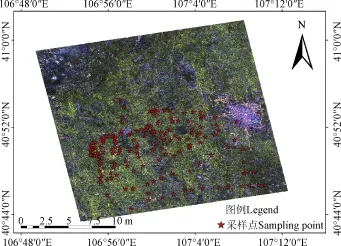
图1 试验区雷达影像图Fig.1 Radar image of experimental area

表1 根据雷达影像获取的样点数据(部分样点)Table 1 Sample data obtained by radar image (partial samples)
1.3 地表参数获取
本研究采用安捷伦微波网络分析仪,通过同轴探针法进行采样点的土样介电常数测量。如表1中所示为部分采样点的介电常数实部值。野外用厘米格网的剖面板测量地表粗糙度,计算获取均方根高度S与相关长度L的数值。地表粗糙度反演模型的初期研究只有均方根高度S或相关长度L之一参与模型运算,不能得到较好的反演结果,科研人员通过对S和L进行组合来表示地表粗糙度,如Zribi等[23]利用S与L组成ZS=S2/L,他们采用的组合参数在模型反演中均取得了理想效果,本文将利用组合参数ZS进行反演建模。用地温计对地温进行3次实时测量,并取均值;用激光粒度仪Helos/B对采样点土样进行土壤颗粒测量,获得黏粒C与砂粒S的百分比含量。用100 cm3的环刀取样测量土样土壤容重。烘干法获取土样重量含水量,并转换为体积含水率。
2 研究方法与结果
2.1 土壤介电常数特性
微波遥感的散射、辐射能量是介电常数的函数[24],Oh等[25]得到了HH/VV、HV/VV与介电常数、地表粗糙度的经验模型。因本次使用C波段Radarsat-2影像,通过两个通道得到HH和VV同极化的数值较大,较为准确。而HV与VH交叉极化数据较小,故使用同极化后向散射系数比的Oh模型进行介电常数与雷达后向散射系数的关系研究。
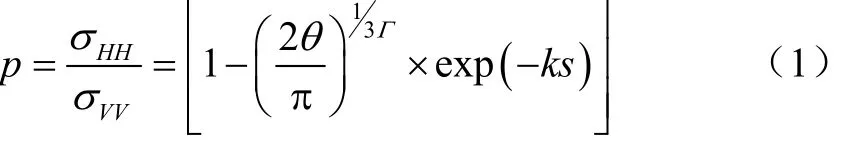
式中是法向入射的菲涅尔反射系数;θ=30.42°为雷达入射角;k为雷达波数;S为均方根高度;σHH、σVV为同极化后向散射系数。
利用采样点的后向散射、介电常数及地表粗糙度数据,按照Oh模型进行介电常数反推计算,其模拟与实测数据的决定系数R2=0.820 9,具有较高的精度,如图2所示。可通过插值的方法得到介电常数的空间分布。
图2 Oh模型介电常数模拟与实测值拟合分析Fig.2 Fitting analysis of Oh model dielectric constant simulated value and measured value
2.2 土壤介电常数模型
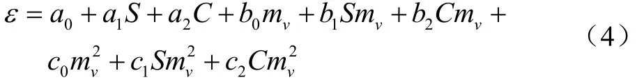
虽然土壤中各成分的介电常数组成了土壤介电常数,但水的介电常数起到了主导作用,所以影响土壤介电常数的最主要因素是土壤水分,此外频率f、温度T和土壤砂粒S、黏粒C等也会对介电常数产生影响[26]。因此,土壤介电常数模型应充分考虑各个因素的影响。目前的介电模型主要分为理论模型、半经验模型、经验模型。
2.2.1 Dobson模型
常用的Dobson模型是利用5种不同土壤类型的实测数据建立的1.4~18 GHz一个半经验的土壤介电常数模型[27],其形式简单、应用方便,只需输入简单参数即可。其模型公式:
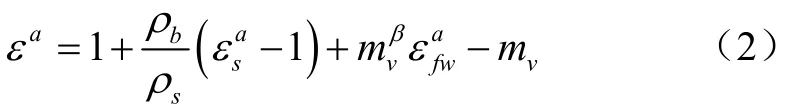
式中ρb是土壤容重;ρs是土壤比重,一般取ρs=2.66;εs为土壤中固态物质介电常数,εs=(1.01+0.44ρs)2−0.062≈4.7;a是一个常数a=0.65;β是与土壤类型即土壤砂土质量百分数和黏土质量百分数有关的复数参数;mv是土壤的体积含水量;εfw为纯水的介电常数;f为入射电磁波频率。
利用采样点地表参数代入Dobson模型获取土壤介电常数实部模拟值,与实测介电常数的决定系数为0.935 9,如图3所示。可见Dobson模型适用于本试验区的介电特性模拟。
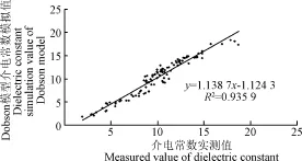
图3 Dobson模型模拟数值与实测数值拟合分析Fig.3 Fitting analysis of Dobson model simulates value and measured value
2.2.2 Hallikainen模型
Hallikainen等[28]在1.4~18 GHz的频率范围内测得不同含水率、不同土壤质地的介电常数。在数据分析的基础上,建立了以土壤质地和含水量为输入变量的经验公式,其通式为:

将此模型改动变成以下公式
将S、C、mv、Smv、Cmv、这8项看作独立变量,其中S砂土百分比、C为黏土百分比含量。将a0、a1、a2、b0、b1、b2、c0、c1、c2这9项看作待求的待定系数,其目的是将原来的非线性问题转化为线性问题。
利用采样点数据建模并验证,发现模拟与实测值的决定系数R2=0.869,如图5所示。


图4 Hallikainen简化实部模型模拟与实测值拟合分析Fig.4 Fitting analysis of simulation value of Hallikainen simplified real part model and measured value
2.3 土壤水分反演模型
多年来国内外学者对土壤介电常数进行了大量的实验研究,在试验数据的基础上,依据介电混合的思想,发展了多种土壤介电常数模型[29]。Dobson模型、Hallikainen简化实部模型模经过他们模拟数据与实测数据相关性分析,表明他们具有较高的相关性。因此本文对Dobson模型、Hallikainen简化实部模型进行公式变形,得到土壤水分反演模型。
2.3.1 Dobson水分反演模型
上文研究表明Dobson模型能够较好反应介电常数与土壤含水率关系,故对Dobson模型进行变形而得到土壤水分反演公式。将Dobson模型公式变为:

对公式(6)进行对数变形,得到土壤水分反演模型:
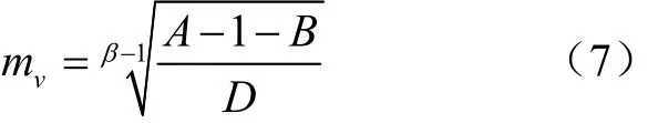
将70个采样点的参数代入公式(7)得到Dobson模型反推含水模拟数值,公式(7)中所用的介电常数为Oh模型反演介电常数得到的数值。通过30个数据对Dobson模型反推含水模拟数值与土壤实测含水值的相关性分析,得到决定系数R2=0.803 8,均方根误差RMSE=0.052,如图5所示。
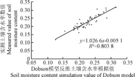
图5 Dobson模型反推土壤含水率模拟数值与实测值的拟合Fig.5 Fitting analysis of Dobson model inversion value and measured value of soil moisture content
2.3.2 Hallikainen水分反演模型
上文研究表明Hallikainen简化实部模型也能较好反映土壤介电常数与土壤含水率关系,故对简化实部模型进行反推,得到Hallikainen简化实部水分反演模型:

将采样点的参数代入公式得到Hallikainen简化实部模型反推含水模拟数值,其决定系数R2=0.737 4,均方根误差RMSE=0.057,如图6所示。

图6 Hallikainen简化实部模型反推土壤含水率模拟值与实测值拟合分析Fig.6 Fitting analysis of soil moisture content simulation value of Hallikainen simplified real part model and measured value
2.3.3 统计回归水分反演模型
根据AIEM正演模型雷达入射角、频率、均方根高度、相关长度、介电常数、水分,改变其中任一变量都会对后向散射系数产生影响[30]。通过对AIEM模型进行机理特征分析发现:对频率变化后向散射系数响应图进行分析,同极化的后向散射系数随着频率的增大而增大;对入射角变化后向散射系数响应图进行分析,同极化的后向散射系数随着入射角的增大而减小;过对均方根变化后向散射系数响应图进行分析,同极化的后向散射系数先随着入射角的增大而增大,到达某一数值后,后向散射系数呈减小的趋势;对相关长度变化后向散射系数响应图进行分析,同极化的后向散射系数随着相关长度的增大而减小;土壤水分变化后向散射系数响应图进行分析发现,同极化的后向散射系数随着土壤水分的增大而增大。在使用雷达影像数据时其入射角、频率是固定值,因此本文用四极化后向散射系数HH、HV、VH、VV及其组合HH/VV、HV/VH,组合地表粗糙度ZS以及Oh模型反演介电常数ε建立经验回归模型,结果如公式(9)所示。其模型反演与实测值决定系数R2达0.8421,均方根误差RMSE=0.05,图7所示。

图7 经验回归模型土壤含水率反演值与实测值拟合分析Fig.7 Fitting analysis of empirical regression model inversion value and measured value of soil moisture content
将剩余的30个数据代入经验回归模型,计算其相对误差,并计算其模拟精度。部分数据见表2所示。
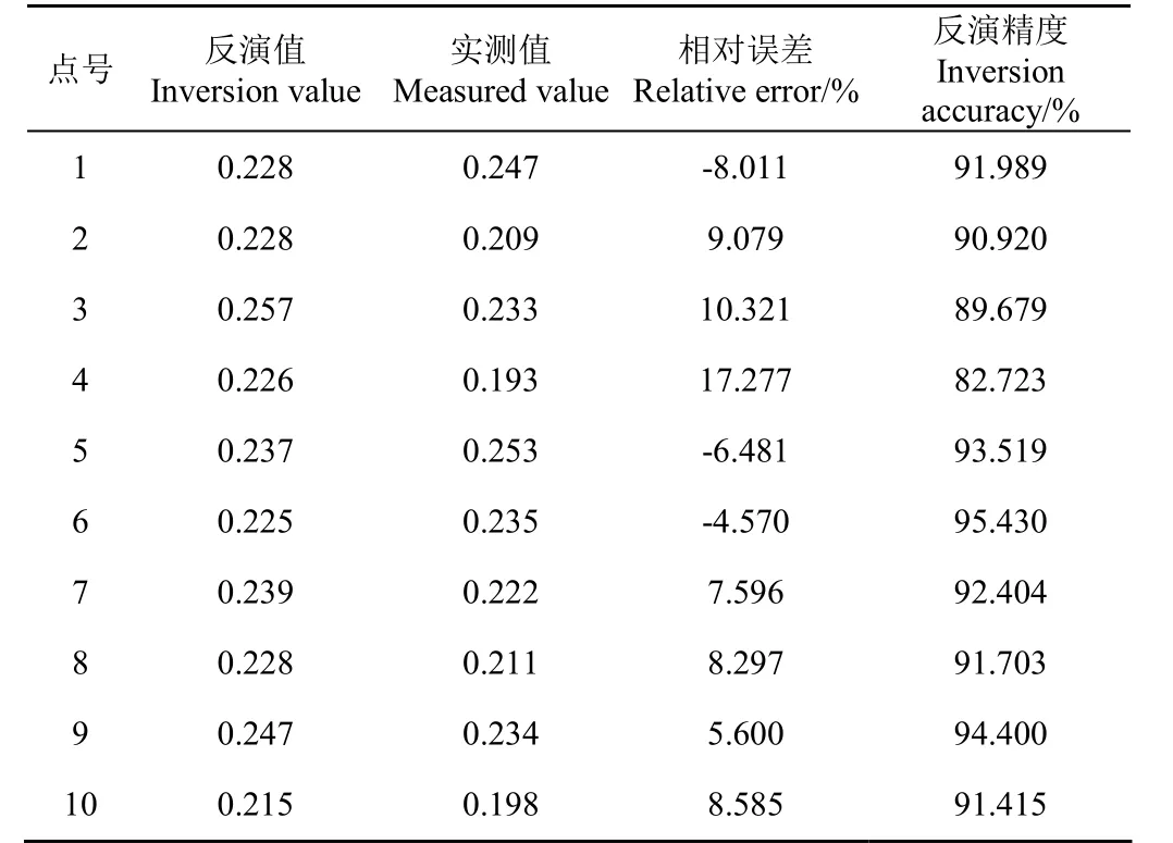
表2 经验回归模型土壤含水率反演精度检验Table 2 Soil moisture content inversion accuracy test of regression model
2.3.4 水分反演模型对比
最后使用 ENVI软件最大似然法对Dobson模型、Hallikainen简化实部模型反推含水率数值与统计回归模型结果分类,得到3种土壤墒情分布图(图8所示)。根据3种模型反演的土壤墒情在空间分布存在明显差异。
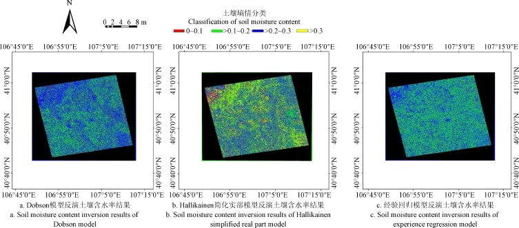
图8 不同模型反演的土壤含水率结果Fig.8 Soil moisture content inversion results of different models
3种模型反演的土壤墒情统计结果如表3所示。
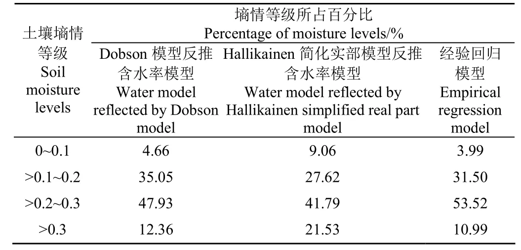
表3 土壤含水率统计结果Table 3 Statistic results of soil moisture content
表3统计了Dobson模型反推含水率模型、Hallikainen简化实部模型反推含水率模型、经验回归模型模拟的不同墒情等级占比,从统计结果可以看出Dobson反推水分模型与统计回归模型所占比重基本相等,其主要原因在于Hallikainen简化实部模型未考虑地表粗糙度影响。
3 结论与讨论
1)通过Oh模型反演介电常数值,能够为介电常数模型反推含水值提供数据的支持。通过对常用的Dobson模型和Hallikainen简化实部模型的验证。发现2种模型都能较好地反映土壤介电常数与土壤含水的密切关系,尤其是Dobson模型的效果更好。
2)经Dobson模型、Hallikainen简化实部模型反推含水率模型验证发现两者均可用于土壤水分反演,且Dobson模型与统计回归经验模型功效较为一致,具有较高的精度与适用性,而Hallikainen简化模型模拟水分的效果劣于前两者。
3)Dobson模型、Hallikainen简化实部模型反推含水率模型、统计回归经验模型三者的土壤墒情分布,在0.2~0.3范围内所占比重较多,说明3种反演水分模型都能够较好的反映试应验区的土壤水分分布情况。
本文推荐的经验模型依赖于地表试验参数,具有区域的限制性。如何从理论模型如AIEM物理模型出发研究各参数间的机理关系建模,以扩大土壤水分反演模型的普适性是今后研究的重点。
[1] Jagdhuber T, Hajnsek I, Papathanassiou K P. An iterative generalized hybrid decomposition for soil moisture retrieval under vegetation cover using fully polarimetric SAR[J]. IEEE Journal of Selected Topics in Applied Earth Observations and. Remote Sensing. 2015, 8: 3911-3922.
[2] Jacome A, Bernier M, Chokmani K, et al. Monitoring volumetric surface soil moisture content at the La Grande Basin Boreal Wetland by radar multi polarization data[J]. Remote Sens, 2013, 5: 4919-4941.
[3] 刘全明,成秋明,王学,等. 河套灌区土壤盐渍化微波雷达反演[J]. 农业工程学报,2016,32(16):109-114. Liu Quanming, Cheng Qiuming, Wang Xue, Li Xiangjun. Soil salinity inversion in Hetao Irrigation district using microwave radar[J]. Transactions of the Chinese Society of Agricultural Engineering (Transactions of the CSAE), 2016, 32(16): 109-114. (in Chinese with English abstract)
[4] 马洪章,刘素美,彭爱华,等. L 波段主被动微波协同反演裸土土壤水分[J].农业工程学报,2016,32(19):133-138. Ma Hongzhang, Liu Sumei, Peng Aihua, Sun Lin, Sun Genyun. Active and passive cooperative algorithm at L-Band for bare soil moisture inversion[J]. Transactions of the Chinese Society of Agricultural Engineering (Transactions of the CSAE), 2016, 32(19): 133-138. (in Chinese with English abstract)
[5] 陈晶,贾毅,余凡. 双极化雷达反演裸露地表土壤水分[J].农业工程学报,2013,29(10):109-115.Chen Jing, Jia Yi, Yu Fan. Soil moisture inversion by radar with dual-polarization[J]. Transactions of the Chinese Society of Agricultural Engineering (Transactions of the CSAE), 2013, 29(10): 109-115. (in Chinese with English abstract)
[6] Dubois P C, Van Zyl J, Engman T. Measuring soil moisture with imaging radars[J]. IEEE Transactions on Geoscience and Remote Sensing, 1995, 33(4): 915-926.
[7] 刘伟. 植被覆盖地表极化雷达土壤水分反演与应用研究[D].北京:中国科学院遥感应用研究所,2005. Liu Wei. Study on Soil Moisture Inversion and Application with Polarization Radar in Vegetated Area[D]. Beijing: Institute of Remote Sensing Applications, Chinese Academy of Sciences, 2005. (in Chinese with English abstract)
[8] Fung A K, Chen K S. An update on the IEM surface back scattering model[J]. IEEE Transactions on Geoscience and Remote Sensing, 2004, 1(2): 75-77.
[9] Notarnicol A, C. A bayesian change detection approach for retrieval of soil moisture variations under different roughness conditions[J]. IEEE Geoscience and Remote Sensing Letters. Lett., 2014, 11: 414-418.
[10] Gorrab A, Zribi M, Baghdadi N, et al. Retrieval of both soil moisture and texture using Terra SAR-X images[J]. Remote Sens., 2015, 7: 10098-10116.
[11] 宋书艺. 滨海土壤微波介电特性研究[D]. 杭州:浙江大学,2012. Song Shuyi. Study on Microwave Dielectric Property of Coastal Soil[D]. Hangzhou: Zhejiang Uiversity, 2012. (in Chinese with English abstract)
[12] 夏明耀,陈志雨. 空间波法测地物介电常数的反演方法[J].电子与信息学报,1999,21(2):252-257. Xia Mingyao, Chen Zhiyu. Inverse formulations for permittivity measurement of ground materials using space-wave method[J]. Journal of Electronics, 1999, 21(2): 252-257. (in Chinese with English abstract)
[13] 贾明权. 典型地物微波介电特性实验研究[D].成都:电子科技大学,2008. Jia Mingquan. Experimental Research on Characteristics of Microwave Dielectric Properties of Typical Terrestrial Objects[D]. Chengdu: University of Electronic Science and Technology, 2008. (in Chinese with English abstract)
[14] 曾江源,李震,陈权,等. SAR土壤水分反演中的介电常数实部简化模型[J]. 红外与毫米波学报,2012,31(6):556-562. Zeng Jiangyuan, Li Zhen, Chen Quan, et al. A simplified model of the real part of the soil complex permittivity for soil moisture estimation from SAR image[J]. J.Infrared Millim. Waves, 2012, 31(6): 556-562. (in Chinese with English abstract)
[15] 雷磊,塔西甫拉提·特依拜,丁建丽,等. 干旱区盐渍土介电常数特性研究与模型验证[J]. 农业工程学报,2013,29(16):125-133. Lei Lei, Tashpolat·Tiyip, Ding Jianli, et al. Constant characteristic and model verification of saline soil dielectric in arid area[J]. Transactions of the Chinese Society of Agricultural Engineering (Transactions of the CSAE), 2013, 29(16): 125-133. (in Chinese with English abstract)
[16] 刘华贵,曾健. 土壤介电常数—含水量关系模型的比较[J].土工基础,2011,25(2):58-64. Liu Huagui, Zeng Jian. Deformation regularity during shallow buried tunnel construction in urban[J]. Soil Engineering and Foundation, 2011, 25(2): 58-64. (in Chinese with English abstract)
[17] 赵昕,黄妮,宋现锋,等. 基于Radarsat 2与Landsat 8协同反演植被覆盖地表土壤水分的一种新方法[J]. 红外与毫米波学报,2016,35(5):519-616. Zhao Xin, Huang Ni, Song Guanfeng, et al. A new method for soil moisture inversion in vegetation-covered area based on Radarsat 2 and Landsat 8[J]. J. Infrared Millim Waves, 2016, 35(5): 519-616. (in Chinese with English abstract)
[18] 李彪. 基于Radarsat-2雷达影像和BP人工神经网络的土壤墒情监测研究[D]. 呼和浩特:内蒙古农业大学,2015. Li Biao. The Study of Monitoring Soil Moisture Based on Radarsat-2 Remote Sensing Images and BP Artificial Neural Network[D]. Hohhot: Inner Mongolia Agricultural University, 2015. (in Chinese with English abstract).
[19] 李成钢. 冬小麦微波散射特性及参数反演研究[D].成都:电子科技大学,2013. Li Chengang. The Characteristics of Microwave Scattering of Winter Wheat and the Study of Parametric Inversion[D]. Chengdu: University of Electronic Science and Technology, 2013. (in Chinese with English abstract)
[20] 郭曼. 基于SAR数据的稀疏植被覆盖条件下的地表土壤水分反演研究[D]. 乌鲁木齐:新疆大学,2012. Guo Mang. Study on Soil Moisture Inversion of Sparse Vegetation Cover Conditions Based on SAR Data[D]. Urumqi: Xinjiang University, 2012. (in Chinese with English abstract)
[21] 郑磊. 基于微波遥感的裸露地表土壤水分反演研究[D].呼和浩特:内蒙古农业大学,2014. Zheng Lei. Research on Bare Surface Soil Moisture Inversion Based on The Microwave Remote Sensing[D]. Hohhot: Inner Mongolia Agricultural University, 2015. (in Chinese with English abstract)
[22] RADARSAT-2 卫星介绍[Z]//中国科学院对地观测与数字地球科学中心·用户简讯,北京:2008(73): 1-12.
[23] Zribi, Dechambre. Surface soil moisture estimation from the synergistic use of the (multi-incidence and multi-resolution) active microwave ERS Wind Scatterometer and SAR data[J]. Remote Sensing of Environment, 2003, 86(1): 30-41.
[24] Owe M, De Jeu R, Holmes T. Multisensor historical climatology of satellite-derived global land surface moisture[J]. Journal of Geophysical Research: Earth Surface (2003-2012), 2008, 113(F01002): 1-17.
[25] Oh Y. Quantitative and retrieval of soil moisture content and surface roughness from multipolarized radar observations of bare soil surfaces[J]. IEEE Transactions on Geoscience and Remote Sensing ,2004, 42(4): 596-601.
[26] 张廷军,晋锐,高峰. 冻土遥感研究进展—可见光、红外及主动微波卫星遥感方法[J]. 地球科学进展,2009,24(9):963-972. Zhang Tingjun, Jing Rui, Gao Feng. Over view of thesatellite remote sensing of frozen ground: visible thermal infrared and radar sensor[J]. Advances in Earth Science, 2009, 24(9): 963-972. (in Chinese with English abstract)
[27] 梁志刚,陈云敏,陈贇. 利用同轴电缆电磁波反射技术测定非饱和土的含水率[J]. 岩土工程学报,2006,28(2):191-195. Liang Zhigang, Chen Yunming, Chen Yun. Measurement of water content of unsaturated soil by TDR technique[J]. Chinese Journal of Geotechnical Engineering, 2006, 28(2): 191-195. (in Chinese with English abstract)
[28] Hallikainen M T, Ulaby F T, Dobson M C, et al. Microwave dielectric behavior of wet soil: part I:Empiricalmodels and experimental observations[J]. IEEE Transactions on Geoscience and Remote Sensing, 1985, GE-23(1): 25-34.
[29] 陈权,曾江源,李震,等. 遥感监测介电常数与土壤含水率关系模型[J]. 农业工程学报,2012,28(12):171-175. Chen Quan, Zeng Jiang Yuan, Li Zhen, et al. Relationship model of soil moisture and dielectric constant monitored with remote sensing[J]. Transactions of the Chinese Society of Agricultural Engineering (Transactions of the CSAE), 2012, 28(12): 171-175. (in Chinese with English abstract)
[30] 任鑫. 多极化—多角度SAR土壤水分反演算法研究[D].北京:中国科学院遥感应用研究所,2003. Ren Xin. A Surface Moisture Inversion Technique Using Multi-Polarization and Multi-Angle Radar Images[D]. Beijing: Institute of Remote Sensing Applications, Chinese Academy of Sciences, 2003. (in Chinese with English abstract)
Inversion and verification of salinity soil moisture using microwave radar
Wang Xue, Liu Quanming※, Qu Zhongyi, Wang Liping, Li Xiangjun, Wang Yaoqiang
(1. Water Conservancy and Civil Engineering College, Inner Mongolia Agricultural University, Hohhot 010018, China)
Soil dielectric constant is the physical basis for soil moisture simulation based on microwave remote sensing, and especially the real part of the dielectric constant is of great significance to the research of the soil dielectric characteristics. Main aim of this study was to investigate capability of C-band RADARSAT-2 SAR (synthetic aperture radar) data applied in the soil dielectric characteristics monitoring and the soil moisture inversion over agricultural fields. Bare area of Jiefangzha sub-district of Hetao Irrigation District in Inner Mongolia of China was selected as the study region, which was influenced by soil salinization seriously. In order to achieve above purposes, an image of Radarsat-2 SAR was bought in April 2016, which has a kind of four fine polarization SLC (single look complex) format, covering an area of 25 km × 25 km with 8 meter ground resolution. Taking spatial uneven distribution of the saline soil into account, 100 sampling points were designed in the study area, and soil digging depth was 10 cm. Hand-held GPS (global positioning system) receiver was used to record coordinates of the sampling points. The experiment data included the soil dielectric real constant, surface roughness, surface temperature, percentages of clay and sand particles, soil bulk density and soil moisture. Agilent microwave network analyzer was used to measure the real part value of soil dielectric constant with coaxial probe method. Surface roughness was measured using centimeter grid profile plate to calculate the value of RMS (root mean square) height and the correlation length, and then composite roughness was got to represent the surface roughness in later research. Real-time ground temperature of the sampling points was measured by geothermometer. Particle analysis was fulfilled with laser particle size analyzer named Helos/B, obtaining the percentage content of clay and sand particles. Soil bulk density was measured by ring cutter. Soil moisture was measured by way of drying. SAR scape module of ENVI software was mainly used to perform the radar image processing, including radiometric calibration, geometric correction, slant range turning and filtering. Four polarization back scatter coefficient values corresponding to the sampling points were extracted based on previous results by spatial analysis module of ArcGIS software. In order to analyze complex relationship between the real part of the dielectric constant with SAR four polarization back scattering coefficients and surface roughness, firstly Oh empirical model was established, for which the relative relationship was significant between simulated and measured soil moisture, and the value of R2was 0.8209. Results showed that Oh model can offer precise real part value of the dielectric constant to inverse the soil moisture based on the soil dielectric model by means of the remote sensing and surface roughness data. Then Dobson semi-empirical dielectric models and simplified Hallikainen real part experience model were verified, and the R2between the measured and simulated real part values was 0.935 9 and 0.869 respectively, which indicated that the 2 models can simulate close relationship of the surface soil moisture and the real part of the dielectric constant. Finally Dobson model and Hallikainen simplified real part soil moisture inversion model were constructed. Compared with the statistical regression model, it looked like that relative relationship between simulated and measured value was significant, and the value of R2was 0.803 8, 0.737 4, and 0.842 1, respectively, for the former 2 models and the statistical regression model, the RMSE (root mean square error) value was 5.2%, 5.7%, and 5% respectively. The inversion results of Dobson model and statistical regression model were similar with the field soil moisture distribution, so they had good precision and applicability. Without considering the surface roughness, the simulation result of Hallikainen simplified real part model was then slightly worse than the other 2 models. The soil dielectric characteristics researching system and the moisture retrieval models established in this study can promote the application of the microwave remote sensing in the soil moisture monitoring.
soil moisture; remote sensing; models; soil dielectric properties; Oh model; Dobson model; Hallikainen simplified real part model; salinization
10.11975/j.issn.1002-6819.2017.11.014
S152.7; P628.2
A
1002-6819(2017)-11-0108-07
王 学,刘全明,屈忠义,王丽萍,李相君,王耀强. 盐渍化土壤水分微波雷达反演与验证[J]. 农业工程学报,2017,33(11):108-114.
10.11975/j.issn.1002-6819.2017.11.014 http://www.tcsae.org
Wang Xue, Liu Quanming, Qu Zhongyi, Wang Liping, Li Xiangjun, Wang Yaoqiang. Inversion and verification of salinity soil moisture using microwave radar[J]. Transactions of the Chinese Society of Agricultural Engineering (Transactions of the CSAE), 2017, 33(11): 108-114. (in Chinese with English abstract) doi:10.11975/j.issn.1002-6819.2017.11.014 http://www.tcsae.org
2017-01-03
2017-03-11
国家自然科学基金项目(51249007、51569018、51169016);内蒙古自然科学基金项目(2013MS0609);“十三五”国家重点研发计划项目(216YFC0501301)
王 学,男,山东济南人,主要从事定量遥感反演理论及应用研究。呼和浩特 内蒙古农业大学水利与土木建筑工程学院,010018。
Email:sdzqwx@126.com
※通信作者:刘全明,男,内蒙古四子王旗人,副教授,博士,主要从事测绘工程教育与定量遥感反演理论及应用研究。呼和浩特 内蒙古农业大学水利与土木建筑工程学院,010018。Email:nndlqm@sina.com
