Models (form) of long-, medium- and short-term earthquake precursors
2022-10-18AbdullabekovKakharbayNasirbekovichYusupovValijonRustamovich
Abdullabekov Kakharbay Nasirbekovich, Yusupov Valijon Rustamovich
Institute of Seismology of the Academy of Sciences of Uzbekistan, Tashkent, Uzbekistan
Keywords:Epicentre Earthquakes Precursor Geodynamic polygon Forecast Magnetic field
ABSTRACT Through analysis and generalization of more than 50 years of monitoring data pertaining to geomagnetic earthquake precursors in landfills across Uzbekistan involving repeated route and area surveys and stationary observations, as well as extensive data retrieved from the study of the complex in foreign countries, models of long-, medium- and short-term earthquake precursors were created for the first time. Medium- and short-term data were mainly studied based on monitoring data of the precursor complex considering geodynamic polygons in Uzbekistan. The analysis demonstrated that these precursors exhibit different shapes, configurations and signs. There occurred no uniform precursor form.Precursors exhibited bay-shaped forms, including both positive and negative signs, in addition to stepped, wave-oscillatory and other formats. The variety of manifestation forms primarily depends on the surrounding regions'geological and tectonic structures and the various processes in the Earth's crust.© 2022 Editorial office of Geodesy and Geodynamics. Publishing services by Elsevier B.V. on behalf of KeAi Communications Co. Ltd. This is an open access article under the CC BY license (http://creativecommons.org/licenses/by/4.0/).
1. Introduction
As we all know, in seismically active regions of the world,including the Uzbekistan region, the natural disasters with a great extent of damage and a large number of casualties belong basically to strong earthquakes. A considerable part of the territory of Uzbekistan locates in seismically active zones,where earthquakes with an intensity of IX or higher on the Medvedev-Sponheuer-Karnik (MSK)-64 and magnitude up to M=7.3 can occur.For example,Andijan(1902)(M=6.8),Akhsikent(1620)(M=5.3),Tashkent(1966)(M=5.3),Gazli(1976 and 1984)(M = 7.3), and many other earthquakes, which led to numerous destruction and human casualties. Therefore, the main scientific direction of the Institute of Seismology of the Academy of Sciences,organized shortly after the devastating Tashkent earthquake on April 26,1966,is the development of scientific and methodological foundations of seismic zoning and earthquake forecasting..
Considering the above, since the mid-90s of the last century,more than 10 Government Resolutions have been issued aimed at developing the necessary measures to reduce the damage of seismic impacts. The Government Resolutions emphasize that we should devote to the “Creation of new models (forms) for the preparation of complexes of precursors of strong earthquakes(medium- and short-term in both time and space) and the determination of patterns of earthquake manifestations” [1], and preserve the lives of people and objects of the economy (Table 1).
This paper aimed to create models (forms) of long-, mediumand short-term earthquake precursors. The following materials were considered to achieve this goal:
●Long-term magnetometric observations obtained via repeated route, stationary measurements and area surveys since 1968 in the Tashkent, Ferghana, and Kyzylkum geodynamic polygons;
●Manufactured facilities (Charvak reservoir, Poltoratskoye underground gas storage, areas of gas and oil fields, etc.), epicentres of previous strong earthquakes, a world network of geomagnetic observatories established since the 19th century[2-5], catalogs of the entire complex of earthquake precursors[6-9], and comprehensive studies of numerous authors worldwide[10-28].
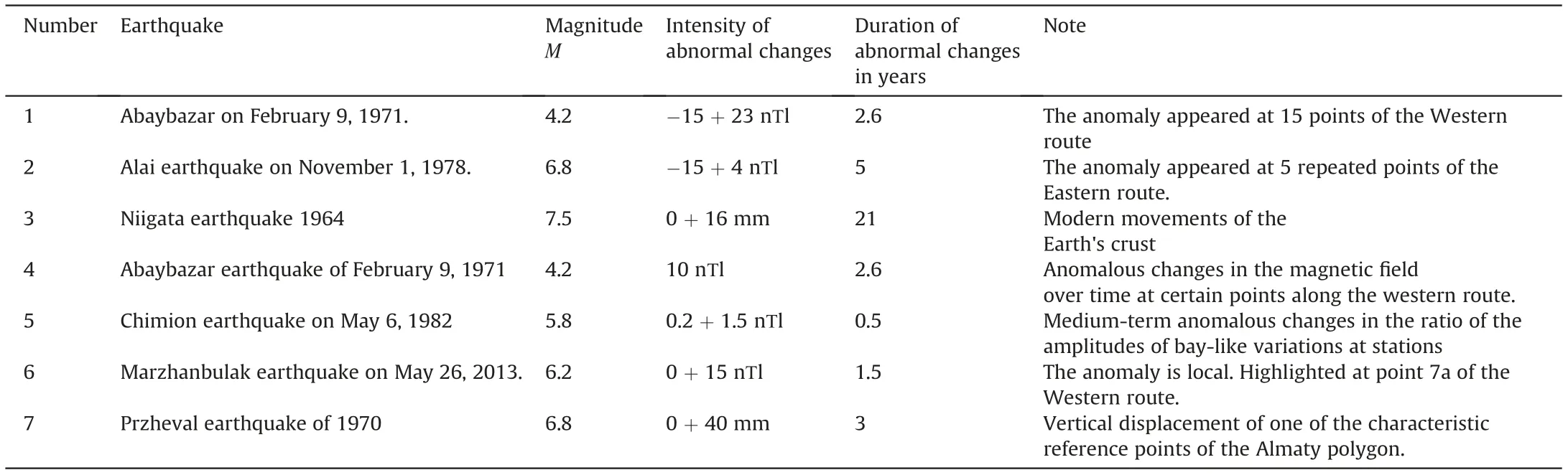
Table 1 A list of long-term, medium-term, short-term anomalous changes in the magnetic field, modern movements of the Earth's crust and other precursors.
2. Methods
Experiments were carried out with the repeated route and area magnetic surveys within a network of stationary magnetometric stations located in specific geodynamic polygons (Fig. 1). The first repeated route survey experiments started in 1968 at the Tashkent Geodynamic test site with the Institute of Terrestrial Magnetism,Ionosphere and Radio Wave Propagation of the Academy of Sciences of the Former USSR (IZMIRAN). Three routes were laid along and across the seismogenic zones.The distance between the points was 5 km.The total length of the routes at this training ground is about 330 km. The modulus of the total vector T was measured using an absolute proton magnetometer PM-5. The measurements were taken to the baseline of the T-variometer of the Yangibazar magnetic Observatory [2-5]. Since the 1970s, the volume of experimental work has gradually increased.In addition to IZMIRAN,the Institute of Earth Physics(Moscow),the Institute of Geophysics(Yekaterinburg),the Institute of High Temperatures (Moscow) and others began to take part in the experiments [2-5]. Measurements began to be carried out with more high-precision instruments:TMP,TM-5,MPP,MV-01 PMP, G-816,GSM-19 T and others.Measurements were carried out synchronously at ordinary and stationary stations.The volume of experimental work gradually increased. Experiments began to be carried out in manufacturing facilities (underground gas storage,high-altitude reservoirs,areas of gas and oil fields,epicentres of strong earthquakes,etc.).Measurements at stationary stations were carried out every 15 days at points of repeated area surveys with a frequency of 10-20 min around the clock, and 3-4 measurement cycles per year at points of repeated route surveys.The total length of the repeated route surveys was larger than 7750 km,the number of repeated measurement points reached approximately 1110, the number of stationary stations ranged from 15 to 25.In certain years,this number even reached 37.
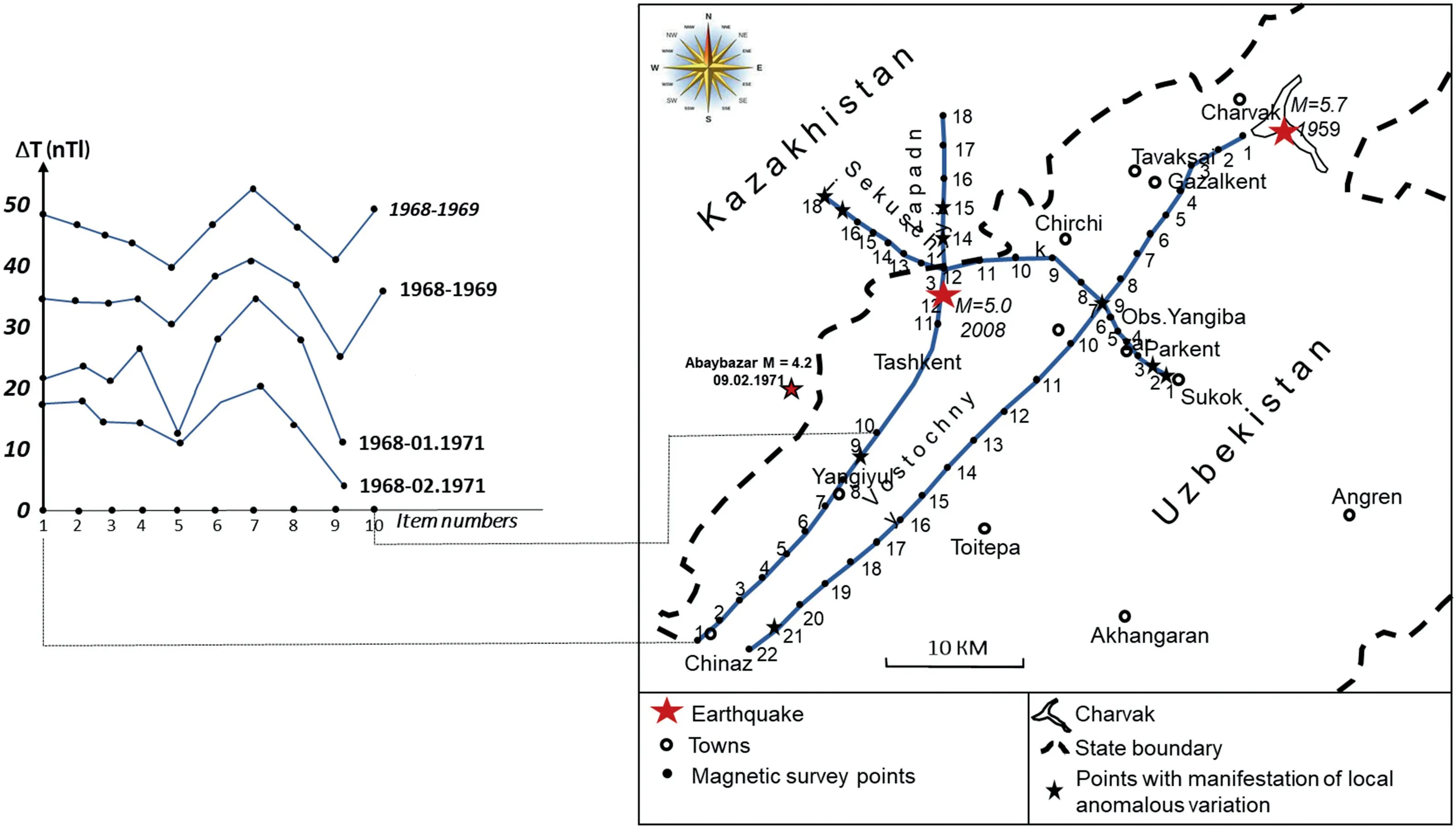
Fig.1. Anomalous changes in the magnetic field along the western profile of the Tashkent polygon associated with the Abaybazar earthquake on February 9,1971 (M = 4.2).
The main purpose of this paper is to create models (forms) of long-term, medium-term and short-term earthquake precursors.Methodological issues are covered in detail in monographs [2-5]and numerous papers by the authors. With regard to the physical causes of abnormal magnetic field changes associated with the preparation and implementation of earthquakes, the authors adhere to the well-known phenomena of piezo magnetism,piezoelectricity and electrokinetics. It was partially given in Ref.[30]that the information related to the stages of preparation of tectonic earthquakes and physical and mechanical phenomena. A particular methodological work by K·N.Abdullabekov and coauthors is devoted selecting earthquakes for comparison with anomalous variations of magnetic and other fields [13]. Based on the purpose and objectives of this paper, following are the most characteristic anomalous changes in the magnetic field, including modern movements of the Earth's crust, variations in the radon content and other precursors identified in geodynamic polygons across Uzbekistan and other countries.
Long-term earthquake precursors were investigated within the abovementioned network of the stationary, repeated route and repeated areal magnetometric observations in geodynamic polygons across Uzbekistan [2-6].
●by analysing average annual data retrieved from the global network of geomagnetic observatories [6].
●literature data on repeated levelling and oceanographic surveys in Japan and other countries [2-6];
●long-term data were encompassing hydrogeoseismological observations in Uzbekistan and other countries [4,5].
3. Research results
According to repeated route observations in the Tashkent, Ferghana and Kyzylkums polygons, long-term anomalous changes in the magnetic field associated with the Abaybazar earthquake on February 9,1971,with a magnitude of M= 4.2,and the Khalkabad earthquake,which occurred on January 9,1971(M=3.7,H=5 km),were identified [1,6]. Moreover, the Isfara-Batken earthquake on January 31,1977(M=5.75),the Tavaksay earthquake on December 6, 1977, with a magnitude of M = 5.2, the Alai earthquake on November 2,1978, with a magnitude of M = 6.8, and other earthquakes were considered.
As an example,Fig.1 shows the results regarding the long-term anomalous changes in the magnetic field associated with the Abaybazar earthquake on February 9, 1971 (M = 4.2), and Fig. 2 shows the Alai earthquake on November 1, 1978, with a magnitude of M = 6.8.
As a result of the analysis of the average annual changes in the magnetic field based on the world network involving 12 geomagnetic observatories, against the background of 60-year variations,anomalous changes in the geomagnetic field with a characteristic time ranging from 15 to 25 years were identified [3,6]. The linear dimensions of these anomalous changes ranged from 100 to 500 km and even greater. These observatories located in areas with active recent and modern movements of the Earth's crust. Only in the Dusheti Observatory did an anomalous change in the magnetic field coincide with the Gori earthquake with a magnitude of M=6.5[3,6].
Fig. 3 shows changes in the heights of the Earth's surface from 1900 to 1965 at several points off the coast of the Sea of Japan[2,19].As shown in the Fig.3,four types of changes in the Earth's surface could be found. The first type, from 1900 to 1931, is characterized by gradual changes in both positive and negative signs.After 1931,long-term changes in the Earth's surface, including positive and negative signs,were observed.These changes continued until 1960,and after this period, medium-term changes in the Earth's surface were observed. The rate of change at the considered points increased. After 1963, the rate of change on the Earth's surface increased even more sharply. Medium-term changes transitioned into short-term changes.At specific points,there occurred a change in the sign of the field anomaly. Finally, in 1964, the strongest Niigata earthquake occurred. The results regarding these actual observations are exceptionally unique around the world.
V.I. Ulomov and M. Mavashev [10] reported long-term anomalous changes in the radon content in the Semashko epicentral well associated with the Tashkent earthquake of April 26,1966.
Long-term anomalous changes were also identified before the Isfara-Batken earthquake on January 31, 1977, the Nazarbayev earthquake on December 11,1980,the Chimion earthquake on May 6,1982, and the Papal earthquake on February 17,1984, etc.
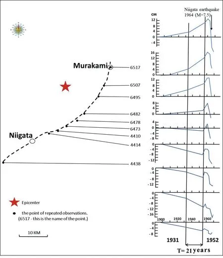
Fig.3. Temporal variations in the vertical displacement of the levelling reference points along the coast of the Sea of Japan before and after the 1964 Niigata earthquake(M=7.5)[2,19].
As indicated by the above data, long-term anomalous changes are reflected by variations in the Earth's magnetic field, modern movements of the Earth's crust and radon content.
Figs.1-4 show the results of the magnetometric and geodetic observations acquired through repeated route surveys. Long-term precursors of the Abaybazar, Alai and Niigata (Japan) earthquakes were identified considering repeated route measurements at 10-15 points.The forms of anomalous changes at individual points included rectilinear positive and negative signs. However,abnormal changes in the profile exhibited bay-shaped patterns.The anomalous changes in the Khalkabad earthquake[2]indicated the form of a negative bay. The anomalous changes in the Tavaksai earthquake revealed an oscillatory increasing trend.
Fig. 5a shows a model (forms) of a long-term magnetic precursor created based on anomalous changes in the magnetic field along the western profile of the Tashkent polygon(Fig.1)associated with the Abaybazar earthquake of February 9, 1971 (M = 4.2),Fig. 5b is based on anomalous changes in the magnetic field along the Karasu-Madaniyat profile (Fig. 2) associated with the Alai earthquake of November 1,1978 (M = 6.8).
Fig.6 shows models(forms)of long-term geodetic and magnetic precursors created based on typical long-term changes in modern movements of the Earth's crust associated with the 1964 Niigata earthquake (M = 7.5) in Japan (Fig. 6) and the Abaybazar earthquake on February 9,1971 (Fig. 2).
The models created considering anomalous changes in precursors along the profile exhibited a barrel shape. In contrast, the models (forms) built considering changes in precursors at individual points demonstrated rectilinear forms with both negative and positive signs.
Fig. 4. Anomalous changes in the magnetic field over time at specific points along the western route associated with the Abaybazar earthquake of February 9, 1971, with a magnitude of M = 4.2 (T, long-term 2.6 years).

Fig. 5. Models (forms) of long-term magnetic precursors based on profiles.
Medium-term anomalous changes in complex geophysical fields, modern movements of the Earth's crust, hydrogeoseismological parameters and other precursors were identified in the Tashkent, Ferghana, and Kyzylkum geodynamic polygons.Monitoring of complex observations was carried out with the methods of repeated route and area magnetometric surveys, in addition to stationary stations[6].The obtained data about Russia,Japan, the USA, China, Greece and other CIS (Commonwealth of Independent States) republics were also considered [21,23].
As an example,characteristic medium-term anomalous changes in geophysical fields, modern movements of the Earth's crust,hydrogeoseimological parameters of groundwater and other fields are given.
In the Tashkent and Ferghana geodynamic polygons, mediumterm anomalous changes in magnetic and other fields were identified before the Isfara-Batken earthquake on January 31,1977,with a magnitude of M = 6.0. Then, several more earthquakes occured,including the Tavasai earthquake on December 6, 1977, with a magnitude of M = 5.2, the Alai earthquake on November 2,1978,with a magnitude of M = 6.8, the Chimion earthquake on May 6,1982, with a magnitude of M = 5.8, the Papal earthquake on February 17, 1984, with a magnitude of M = 5.5, the Hamzaabad earthquake on June 28,1985,with a magnitude of M=4.8,and the Marzhanbulak earthquake on May 26, 2013, with a magnitude of M = 6.2 [33].
An anomalous change in the ratio of cove-like variations at the Chimion station relative to the Yangibazar station was also revealed at the stationary Chimion station(Fig.7).In regard to the analysis,bay-shaped variations with periods ranging from 0.5 to 3 years were employed [6].
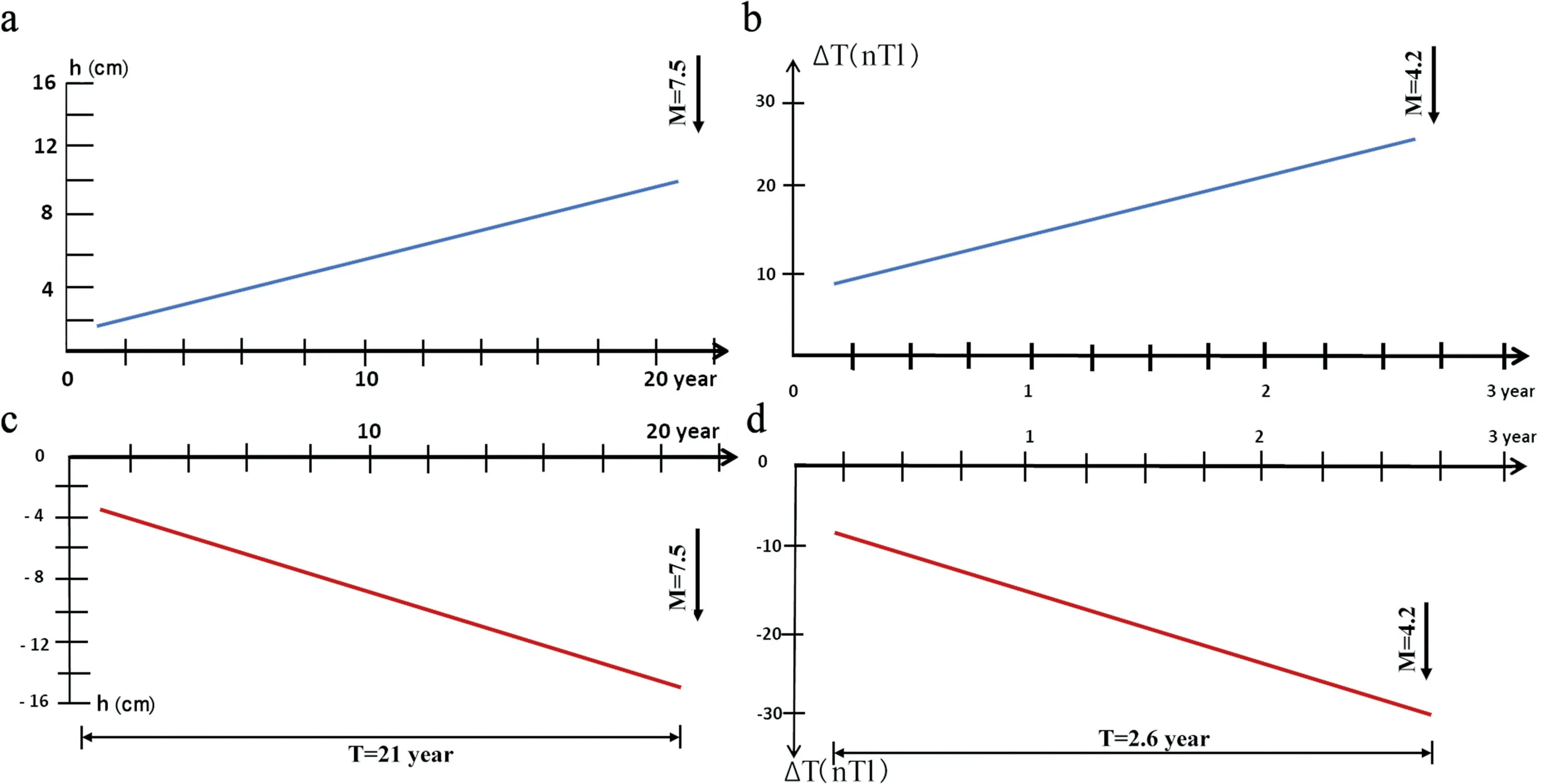
Fig. 6. Models (forms) of long-term geodetic and magnetic precursors over time.

Fig.7. Medium-term anomalous changes in the ratio of the amplitudes of bay-like variations at stations Chimion(1) and Madaniyat(2)in relation to Yangibazar observation data associated with the Chimion earthquake on May 6,1982 (M = 5.8).
Fig. 8 shows medium-term anomalous changes in the Marzhanbulak earthquake on May 26, 2013, with a magnitude of M=6.2 at the Bukhara and Shurchi stations.The characteristic time of the anomalous change reached approximately one year. The intensity at the Bukhara station ranged from 6 to 8 nTl, and at the remote Shurchi station, the intensity reached approximately 3-4 nTl.
During monitoring of magnetic field variations at the stationary stations and points of repeated route surveys, numerous anomalous changes in the magnetic field associated with earthquakes exhibiting magnitudes ranging from 4.5 to 6.0 were identified [6].
Fig. 9 shows graphs of the vertical displacement of one of the characteristic reference points of the Almaty polygon during the Przhevalsky (Sarykamyshsky) earthquake of 1970 with a magnitude of M = 6.8 according to Ref. [17]. The intensity of the anomalous changes in the Earth's surface associated with the Sarykamysh earthquake reached approximately 40 miles. From 1968 to 1970, there occurred a sharp increase in the modern movements of the Earth's crust by 40-43 miles. After the earthquake,a return to the initial level of the movements was observed.The total duration was 2.5 years.The sign of the anomalous changes was positive. The shape was bay-shaped.
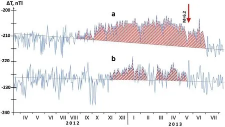
Fig.8. Medium-term anomalous changes in the magnetic field associated with the Marzhanbulak earthquake on May 26,2013,with a magnitude of M=6.2 at the Bukhara(a)and Shurchi (b) stations.
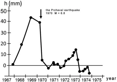
Fig.9. Vertical displacement of one of the characteristic reference points of the Almaty polygon during the period, including the Przheval (Sarykamysh) earthquake of 1970 with a magnitude of M = 6.8 [17].
To reliably predict earthquakes, research should be carried out in at least three ways.The current study will focus on the prediction of earthquakes via magnetometric and geodetic methods. According to the Ref. [13], the precursor of an earthquake with a magnitude of M = 5 can be observed at a distance of 115 km and a time of 171 days. A given precursor is considered reliable when the abnormal change under study is manifested at least at 5-10 observation points.
Fig. 10 shows models (forms) of medium-term magnetic and geodetic precursors over time.These models(forms) were created based on numerous typical medium-term magnetic precursors identified in landfills across the Republic of Uzbekistan. Literature data were employed to select geodetic precursors (Fig. 10). The figures reveal that the models(forms)exhibited bay-shaped forms,including both negative and positive signs.
The short-term geophysical precursors of earthquakes have been studied with a network of stationary magnetometric, pulsed electromagnetic, electrometric and other methods in Uzbekistan region. Comprehensive studies of short-term methods have also been conducted in Russia and other CIS republics,China,Japan,the USA, Germany, Greece and other countries [14-29]. Short-term geophysical precursors have also been investigated with the help of a worldwide network of geomagnetic observatories and various international projects. To achieve this goal, long-term monitoring data of complex seismic prognostic observations within the network of stationary stations of the Institute of Seismology, a complex expedition of the Institute of Seismology, and the data retrieved from the Republican Center for Seismic Prognostic Monitoring of the Ministry of Emergency Situations of the Republic of Uzbekistan since 2019 were analysed. Literature data of numerous researchers from a number of countries on the spatiotemporal patterns of the manifestation of the complex of precursors and models (forms) of earthquake preparation were also employed[30-33].Catalogs of various earthquake precursors were further considered [6-9].
For example, we will provide information on the short-term precursors of earthquakes. These precursors were registered in different years in varying regions of the globe. Fig. 11 shows an anomalous change in the magnetic field at the Andijan stationary station associated with the Alai earthquake of November 2,1978,with a magnitude of M=6.8.A sharp change was observed a week before the earthquake. By October 30, this anomalous change reached a maximum of 23 nTl, when the sign of the field anomaly changed.The earthquake occurred two days after the above change in the field anomaly sign 130 km south of the Andijan station on November 2,1978, with a magnitude of M = 6.8 [33].
Fig. 12 shows abnormal changes in the magnetic field at the stationary stations Madaniyat (a), Andijan (b) and Tashata (c)associated with the Marhamat earthquake on February 19, 1986,with a magnitude of M = 4.4. At three stations, a sharp abrupt change in the magnetic field intensity ranging from 4 to 7 nTl was synchronously observed on February 5,1986. During the last 7-8 days, gradual attenuation of the field intensity by 2-4 nTl was observed. The Marhamat earthquake occurred on February 19,1986,40-50 km from the stationary stations of Madaniyat,Andijan and Tashata.
From 1978 to 1984,about 75 short-term anomalous changes in the geomagnetic field with an intensity ranging from-7 to+23 nTl were identified in the network of stationary stations. The manifestation form also differed: positive and negative bay-shaped changes, stepped changes, fluctuating changes with a positive or negative sign,etc.The manifestation time ranged from several days to 10 days and sometimes reached up to one month. The manifestation time of the observed abnormal changes in pulsed electromagnetic radiation was the shortest,ranging from a day to 5-6 days.The geomagnetic time ranged from a day to one month,while the hydrogeoseismological time reached 2-3 weeks.
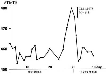
Fig. 11. Anomalous changes in the magnetic field at stationary station Andijan associated with the Alai earthquake on November 2,1978, with a magnitude of M = 6.8,which occurred 130 km from the station [33].
Fig.13 shows models(forms)of short-term magnetic and pulsed electromagnetic precursors. As indicated by the above examples,these models (forms) of short-term precursors exhibited diverse and complex forms. The manifestation times were also different,ranging from a day to several weeks,sometimes reaching up to one month.
4. Discussion
As can be seen from the analysis of data from long-term comprehensive studies of earthquake precursors at landfills in Uzbekistan, as well as numerous results obtained in other countries, the problem of earthquake forecasting is a challenging and multifactorial task. There are also general problems and specific questions concerning each method separately. In this study, we tried to find common spatial and temporal features of the manifestation of the harbinger complex depending on the magnitude of earthquakes. Although the precursors manifest in the form of abnormal variations of the Earth's magnetic field, modern movements of the Earth's crust and various parameters of underground mineral waters and other fields, the primary cause leading to abnormal changes are the accumulation of elastic stresses in the earth's crust. The creation of long-term, medium-term and shortterm models (forms) of the precursor complexes will make it possible to develop models (forms) of earthquake preparation processes at the next stage.

Fig.12. Anomalous changes in the magnetic field at the stationary stations of Madaniyat (a), Andijan (b) and Tashata (c) associated with the Marhamat earthquake of February 19,1986, with a magnitude of M = 4.4.

Fig.13. Models (forms) of short-term magnetic and pulsed electromagnetic precursors.
5. Conclusion
Long-term data of complex magnetometric research involving geodynamic polygons via stationary observations and repeated route and area surveys, century-old course data of the world network of geomagnetic observatories and literature data on deform-metric,hydrogeoseismological and the other research were collected, categorized and generalized.
The study also provides the information on the shape,intensity and spatiotemporal characteristics of long-, medium- and shortterm precursors of geomagnetic, pulsed electromagnetic, deformmetric, and hydrogeoseismological precursors of earthquakes.
Through analysis and generalization of long-term monitoring data of electromagnetic earthquake precursors in landfills across Uzbekistan based on repeated route and area surveys and stationary observations, as well as extensive literature data on the entire complex of precursors in Uzbekistan and abroad, models(forms) of long-, medium- and short-term earthquake precursors were created for the first time.
In the future, it is also planned to modernize existing geodynamic polygons by optimizing the number of existing stations and increasing new methods of earthquake forecasting. It is also planned to strengthen international relations with seismological organizations of the People's Republic of China, Russia and other countries.The Academy of Sciences of Uzbekistan and the Institute of Seismology express endless gratitude to the Leadership of the PRC and its seismological organizations for allocating five sets of modern seismic equipment to the Institute of Seismology in the early 2000s.
Conflicts of interest
The authors declare that there is no conflicts of interest.
Acknowledgements
The authors express their gratitude to Professor S.H.Maksudov for participating in the discussion. This research was conducted with the financial support of the State Basic Research Development Program (2021) of the Committee for the Coordination of Science and Technology Development under the Ministry of Innovation of the Republic of Uzbekistan.
杂志排行
Geodesy and Geodynamics的其它文章
- A new polar motion prediction method combined with the difference between polar motion series
- Insights into spatio-temporal slow slip events offshore the Boso Peninsula in central Japan during 2011-2019 using GPS data
- Local seismic hazard map based on the response spectra of stiff and very dense soils in Bengkulu city, Indonesia
- Coastal transgression and regression from 1980 to 2020 and shoreline forecasting for 2030 and 2040, using DSAS along the southern coastal tip of Peninsular India
- Thermospheric density responses to Martian dust storm in autumn based on MAVEN data
- Crustal structure of the Qiangtang and Songpan-Ganzi terranes(eastern Tibet) from the 2-D normalized full gradient of gravity anomaly