Assessment of water level threshold for groundwater restoration and overexploitation remediation the Beijing-Tianjin-Hebei Plain
2022-06-27HuifengYangRuifangMengXilinBaoWengengCaoZeyanLiBuyunXu
Hui-feng Yang, Rui-fang Meng*, Xi-lin Bao, Wen-geng Cao, Ze-yan Li, Bu-yun Xu
1 Institute of Hydrogeology and Environmental Geology, Chinese Academy of Geological Sciences, Shijiazhuang 050061, China.
2 National Field Scientific Observation and Research Station on Groundwater and Ground Subsidence in the Plain Area of Cangzhou, Hebei 050061, China.
Abstract: The Beijing-Tianjin-Hebei Plain (BTHP) is the political, economic and cultural center of China,where groundwater is the main source of water supply to support social and economic development.Continuous overdraft of the resources has caused a persistent decline of groundwater level and formed a huge cone of depression at a regional scale. This paper addresses current groundwater situation over the BTHP area. The paper also delineates the groundwater flow field, using groundwater level data, in order to provide an effective method for the restoration of groundwater level and associated water resources management. Based on the analysis of multiple factors, such as groundwater level, soil salinization, ground subsidence, groundwater recharge and storage, urban underground space security, formation of fractures,and seawater intrusion, the threshold for groundwater level restoration is defined, and some measures for groundwater over-exploitation management are accordingly proposed. The study shows that: (i) Since the 1980s to 2020, shallow groundwater level in the western part of the BTHP area has dropped by 25 m to 60 m, while the cumulative decline of deep groundwater in the central and eastern regions is in the range of 40-80 m; (ii) The water table of the shallow groundwater within the depression zone over the Western Piedmont Plain should be controlled in the range of 15-30 m below ground level (mbgl), while the depth of groundwater level in large and medium-sized urban areas should be controlled within 20-30 mbgl. The groundwater level in the resource preservation area should be controlled within 10-15 mbgl, and the groundwater level in the area with identified soil salinization in the central and eastern plain should be controlled within 3-10 mbgl. However, for the deep groundwater in the central and eastern plainwater, the main focus of the resources management is to control the land subsidence. The water level in the severe land subsidence area should be controlled within 45-60 mbgl, and in the general subsidence area should be controlled within 30-45 mbgl; (iii) Based on the water level recovery threshold and proposed groundwater overdraft management program, if the balance of abstraction and recharge is reached in 2025, the shallow groundwater abstraction needs to be gradually reduced by about 2×10⁸ m3. Meanwhile, the ecological water replenishment of rivers through the South-to-North Water Transfer Project should be increased to 28.58×10⁸ m3/a, and the deep groundwater abstraction needs to be gradually reduced by 2.24×10⁸ m3. To reach the target of shallow groundwater level in 2040, surface water replacement is recommended with a rate of 25.77×10⁸ m3/a and the ecological water replenishment of rivers in the South-to-North Water Diversion Project should reach 33.51×10⁸ m3/a. For deep groundwater recovery, it is recommended to replace the deep freshwater extraction with the utilization of shallow salt water by 2.82×10⁸ m3 , in addition to the amount of 7.86×10⁸ m3 by water diversion. The results are of great significance to the remediation of groundwater over-exploitation, the regulation of water resources development and utilization, and ecological protection in Beijing-Tianjin-Hebei plain.
Keywords: Beijing-Tianjin-Hebei Plain; Groundwater over-exploitation; Groundwater level restoration threshold; Groundwater reserve; Over-exploitation control
Introduction
The Beijing-Tianjin-Hebei Plain (BTHP) is the political, economic and cultural center of China.The Beijing-Tianjin-Hebei Cooperative Development Area and the Xiong’an New Area, a Chinese national millennium project, are both located in this region, rendering the geographical importance of this area. The region is the main grain production area in China, but also one of the most waterdepleted areas in China. As a major source of water supply, groundwater resources are critical to underpin socio-economic development and ecological protection in the region (Hu et al. 2020;Wang et al. 2020; Zhao et al. 2021). Since the late 1970s, the area has experienced continuous drought, as a result the groundwater exploitation has become more intensive, leading to the decline of groundwater level and the formation of groundwater depression cone on a regional scale, which has caused serious environmental and geotechnical problems. Liu et al. (2001) reported that the longterm groundwater overdraft has been the main cause of ground subsidence, seawater intrusion and other environmental problems in the region. Therefore, measures for groundwater overdraft management and groundwater level restoration should be implemented immediately and properly to alleviate the situation (Chen et al. 2021). The accumulated groundwater deficit in the BTHP area is huge, and the goal of groundwater overdraft management is not only to achieve a balance between the resources exploitation and recharge, but also to determine a reasonable ecological water level restoration threshold, so that groundwater in the area can still play an important role in the social and economic development and ecological environmental protection. Since 2014, with the implementation of the South-North Water Diversion(SNWD) project which has brought large amount of additional water to the BTHP for water supply and groundwater overdraft remediation purposes,the situation has been alleviated to a certain extent,but there are still some gaps need to be filled. The main methodology used in previous management measures still focused on water quantity constraints, with the main purpose of reducing groundwater extraction to achieve the balance of extraction and replenishment, but limited researches have been done on determining the thresholds of groundwater level recovery, which is a key factor in the overdraft management program.
A lot of researches have been conducted on groundwater level change and groundwater overdraft management in the Beijing-Tianjin-Hebei region. Feng et al. (2014) analyzed the characteristics of groundwater flow dynamics and its driving factors in the region. Li et al. (2017; 2018) quantitatively identified the dominant factors of groundwater level change; Wang et al. (2012) and Xu et al. (2015) studied the dynamic changes of groundwater level and the impact on the evolution of saline soils. In terms of groundwater overdraft management, Shi et al. (2010; 2011) evaluated the deep groundwater overdraft situation in the North China Plain by combining ground subsidence and groundwater level decline. Li et al. (2014) carried out an assessment of the effect of overdraft management in Cangzhou area, based on groundwater level change analysis. Liu et al. (2016) assessed the extent of groundwater overdraft in the North China Plain and put forward suggestions to improve the groundwater resource capacity. Wei et al. (2019)identified the changes and control factors of groundwater overdraft in the North China Plain. Li et al.(2020) and Yu et al. (2020) proposed regulation and control recommendations based on the evaluation of groundwater overdraft. Chen et al. (2020)and Zhao et al. (2020) analyzed the main problems faced in the area of groundwater overdraft management and put forward relevant consideration. In terms of water level regulation in groundwater overdraft management, only a few researchers have made some explorations. Li et al. (2010)carried out a study on delineation of groundwater level protection target for the large-scale depression area in the North China Plain; Zhu et al.(2020) calculated the critical groundwater levels in the overdraft management area by using mathematical and statistical methods. The above-mentioned studies have achieved great results, but most of them focused on the evaluation of groundwater depletion status and associated management solutions, while very few studies have been done on water level regulation and water level restoration threshold, which are the most critical aspects of overdraft management.
This paper presents a systematic analysis of the regional groundwater level restoration using an index system. Based on comprehensive analysis of regional groundwater level characteristics, a groundwater level restoration index system is constructed,with a target groundwater restoration level initiated at the beginning of the 1980s when massive resources were extracted. The index system is constrained by the groundwater storage function, groundwater depression cone restoration, ground subsidence prevention and control, urban underground space safety guarantee, and soil salinization prevention and control. At the same time, numerical groundwater simulation has been used and a refined groundwater overdraft management model relating to the water level restoration threshold is proposed based on the simulation result. The results show that by 2025, the groundwater level will be balanced and the water table will be restored by 2040. The numerical simulation results show that the groundwater depression cone caused by overdraft will gradually disappear by 2040, and the groundwater level will recover to the expected target. It is expected that the groundwater overdraft management plan is reasonable and reliable.
1 Study area
The BTHP area, located between 112°-120°E and 35°-43°N, is the political, economic and cultural center of China. Bounded by Yanshan Mountains in the north, the plains of northern Lu and northern Henan in the south, Taihang Mountains in the west and the Bohai bay in the east the area is topographically high in the southwest and low in the east, covering an total area of 9.38×10⁴km2. The drainage system in this region consists of Luan river, and parts of Haihe river. The Luan river originates in Fengning County, Inner Mongolia Plateau, with a total length of 888 km, the northern part of Haihe river mainly originates in Inner Mongolia Plateau and Yanshan Mountain Range,consisting of Ji Yun-Chaobai river and Yongding river systems. The southern part of Haihe River originates in Taihang Mountain Range, consisting of Daqing, Ziya and Zhangwei rivers (Fig. 1).
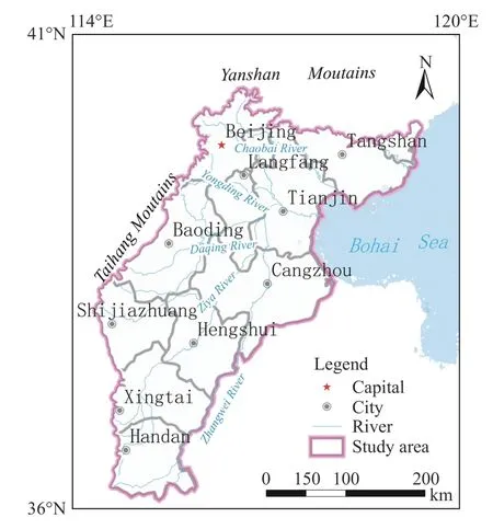
Fig. 1 Geographical location map of Beijing-Tianjin-Hebei Plain
The region has a temperate-continental monsoon climate with four distinct seasons. In general, the trend of precipitation has declined since the 1960s,but it is slightly increases in recent years, with an average annual evapotranspiration of 1 106.9 mm.From 1956 to 1979, the average annual precipitation in Beijing, Tianjin and Hebei was 571.9 mm;from 1980 to 2000, the average annual precipitation decreased significantly to 517.6 mm; from 2001 to 2013, it reduced to 502.5 mm/a, but between 2014 and 2020 the value slightly rebounded to 507.6 mm/a.
In the plain area, the porous aquifers with phreatic water mainly consist of the plain sediments which are alluvial flood plains in the front of mountains, alluvial lake plains in the center and alluvial marine plains in the east. The aquifer system can be divided into four aquifer groups from the top to the bottom.
Aquifer group I, bottom of the aquifers is generally shallower than 50 m in depth, which is an alternate layer of active groundwater circulation.The layer is of less significance in respect of groundwater development and utilization, but it plays an important role in the preservation of ecological environment. In the alluvial fan area,the aquifer is mainly composed of sandy and gravely soils, with a thickness ranging from 30 m to 50 m. In the zones between alluvial fan and the mountain fronts, the thickness of the aquifer decreases with the soil particle size becoming finer. In the palaeo channel area of the central plain, the aquifers mainly consist of silt and finegrained sands, with the thickness of 10-30 m. The aquifers mainly composed of silt and fine sands in the inter-river belts are poorly developed, with the thickness of less than 10 m. In the coastal plain, the aquifers mainly consist of silt and fine sands with the thickness of less than 10 m.
Aquifer group II, the bottom of the aquifers is generally less than 120-210 m deep. Groundwater in the aquifer is lightly pressurized or semiconfined, with relatively high aquifer permeability.the aquifers are the main sources of groundwater extraction for agricultural uses in the mountain front plain. There often is a good hydraulic connection the mountain front plain and the group I aquifer, because of no obvious flow barrier between them. The aquifers are dominated by gravels and medium-coarse grained sands in the front plain, medium-fine grained sands in the central plain, and silt and fine grained sand in coastal plain.
Aquifer group III, the bottom of the aquifers is generally in 250-310 m deep. Groundwater flow in the aquifers is generally pressurized with low permeability due to confined property; and the water is the main source for agricultural uses in the central-eastern plains. The aquifers in the mountain front plain consist of sandy and gravely soils with 3 to 4 sedimentary rhymes, while the aquifers in the central plain consists of 3-4 layers of fine sandmedium grained sands. In the coastal plain, the aquifer is mainly silt and fine-grained sand. There is sandy clay with a thickness of not less than10 m commonly distributed between the aquifer groups II and III, resulting in a weak hydraulic connection between the aquifer groups.
Aquifer group IV, the bottom of the aquifer is 350-550 m deep, with a slow groundwater flow,and this type of aquifers has partially been exploited in the coastal plain areas. In terms of aquifer composition, the water-bearing layers are thinning and the particle sizes are finering from the mountain front plains to the coastal plains, with a weak hydraulic connection to the aquifers of group III.
According to Zhang et al. (2009), shallow groundwater can be located at the depth of 80-120 m in the groups I and II aquifers in the pre-mountain plain. In the central-eastern plains the shallow groundwater can be observed at the depth of 60 m in the group I aquifers with brackish and saline water is widely. The deep groundwater is mainly distributed in groups III and IV aquifers over the pre-mountain plain and groups II and III aquifers in the central-eastern plain (Fig. 2).

Fig. 2 Hydrogeological profile of the Beijing-Tianjin-Hebei Plain modified from ( Zhang et al. 2009)
Prior to 2014, water supply in the region was highly dependent on groundwater which provided 72.16% supply in the years of 2001-2013, according to the water resources bulletins of Beijing,Tianjin and Hebei Province. However, since the operation of South-to-North Water Diversion Project in 2014, the figure has significantly dropped to 57.93%. In addition, external water imported from the water transfer project from the Yellow River to the Yellow and Yangtze divisions has increased in the imported water quantity in the area by 1.71% in 2001-2013 to 10.32% since the year of 2014.
2 Data and methodology
2.1 Data
In order to properly delineate the groundwater flow field and accurately evaluate the changes in groundwater storages, a groundwater level survey campaign has been conducted over the BTHP and was completed in 2020. During the survey, the water level data in 6 598 sites have been collected from various sources, which included 3 896 sites of shallow groundwater level and 2 702 sites of deep one, with a density of surveyed site in the key areas of more than 8 sites/100 km2. Based on data derived from the groundwater survey, three periods of groundwater activity are identified, i.e. premining period by the 1980s, extensive withdraw or overdraft period from the late 1980s to 2013, and the period of receiving external recharge due to the operation of SNWD project after 2014. The survey also collected shallow groundwater level contours maps of the year of 1984, 2005, 2010 and 2014,and the deep groundwater head contour maps of 1980, 2005, 2010 and 2014.
The groundwater resources data were obtained from the National Seventh Five-Year Plan Project No.57, Evaluation of Underground Resources in North China, Investigation and Evaluation of Sustainable Use of Groundwater in North China Plain,and Investigation and Evaluation of Surface Water and Shallow Groundwater in Beijing-Tianjin-Hebei Region. Moreover, the data of groundwater exploitation were obtained from the National Seventh Five-Year Plan Project 57 Evaluation of Underground Resources in North China, Investigation and Evaluation of Sustainable Utilization of Groundwater in the North China Plain, Beijing and Tianjin water resources bulletin data, and Hebei geological environment monitoring report data.
2.2 Groundwater storage estimation
The data of water levels over the BTHP measured since the 1980s was used to analyse the water level fluctuation, by using Pan-Kriging interpolation method in GIS software. The analytical results together with groundwater data of specific yield and storativity estimated from previous study, were then used to assess the changes of groundwater storage in the past 40 years for the aquifers over the plain area.
It was noted that the storage changes caused by ground subsidence were considered for deep water.The calculation process of groundwater storage variables in the shallow layer is given by the following Equation.

Where: Qsis the shallow groundwater storage(108m3);irepresentsithunit calculation partition; Firepresents the area of theithunit calculation partition (km2);μiis specific yield for unconfined aquifer of theithunit calculation partition(dimensionless); Δhiis water level variation value(m) of theithunit calculation partition.
The procedure of calculating the deep groundwater storage is shown as follows (Zhang et al.2009).

Where: Qdrepresents the deep groundwater storage (108m3);iisithunit calculation partition; Firepresents area size of theithunit calculation partition (km2); S*iis storativity of theithunit calculation partition (dimensionless); Δhiis head variation value (m) of theithunit calculation partition; Siis average ground subsidence (mm) of theithunit calculation partition for InSAR monitoring data.
3 Groundwater level restoration threshold index system
3.1 Groundwater level restoration thresholds in different regions
The large-scale groundwater exploitation in the BTHP area commenced in the mid-late 1970s, and since the 1980s the exploitation activity has caused a series of environmental geological problems such as the occurrence of groundwater depression cone,ground subsidence, seawater intrusion and ground fracture. The strategy of water level recovery in the pre-mountain plain focuses on groundwater storage and the security of underground space in large and medium-sized cities; and the measure of water level recovery in the central-eastern plain focuses on soil salinization prevention and control and the maintenance of wetland ecological function. On basis of these objectives, the threshold of groundwater level restoration is identified to ensure that the functions of water resources, environment and ecosystem can be fully performed.
3.1.1 Groundwater level restoration threshold in the area of groundwater depression cone prevention and control
The initial groundwater level for restoration threshold analysis is determined, based on the groundwater flow field in the early 1980s when largescale groundwater exploitation had not yet triggered the regional groundwater depression cone. The shallow groundwater depression cone is mainly located in the front edge of mountain front fluvial fan, where the groundwater receives lateral recharge from the mountain front. At the same time,additional recharges occurs with direct sources from river infiltrations and the add-in water via the SNWD project, which is favorable for the recovery of groundwater levels. The deep groundwater depression cone, mainly located in the centraleastern plain, can only be recovered through the replenishment of the SNWD water sources, reduction of the deep water withdraw and utilization of shallow salty water.
3.1.2 Groundwater level restoration threshold for urban underground space safety
For cities and its adjacent areas, the objective of groundwater level restoration is to ensure the security of underground space, minimize the impact of groundwater level lowering on subway structures in large and medium-sized cities, and to maintain the safety of the other construction foundation.Based on the current situation of urban development, the groundwater levels in Beijing and Shijiazhuang cities should be controlled at 20-30 m deep. Tianjin is located in the central and eastern plains, where the groundwater level is shallow. As the use of underground space has taken into account the current groundwater level, underground space’s safe water level in Tianjin is no longer a key consideration.
3.1.3 Groundwater level recovery threshold in soil salinization prevention and control area
Xie et al. (2007) and Zhao et al. (2010) addressed that the minimum depth of phreatic water level is critical in controlling soil salinization which is related to the lithology and minerals in overlying vadose zone. The potential zones with soil salinization in the study area mainly distribute in the central alluvial and eastern coastal plains, where the lithologies of vadose zone are mainly sandy soil and clay soil, and the shallow groundwater is brackish and semi-saline. In coastal plain, the groundwater is characterized by the localized occurrence of brackish water with high salt load and deep groundwater level. According to the results of the ecological and geological survey in Baiyangdian area conducted by China Geological Survey,the phreatic water table in the Baiyangdian and adjacent wetland areas needs to be 4-5 m deep to maintain the functions of water resources, groundwater dependent ecosystem, biodiversity and wetland landscape. Considering soil salinity control and ecological water level constraint in the lake wetland, the critical depth of groundwater level is determined to be 3-4 m deep (Ma et al.2020).
3.1.4 Groundwater level recovery threshold in ground fracturing prevention and control area
At present, the overall ground fracturing in BTHP area is growing, mainly triggered by the decline of shallow groundwater level. According to the results of the ground fracture survey, the occurrence probability of ground fracture may significantly increases when the shallow groundwater level in the pre-mountain plain is deeper than 10 m. In the meantime, the occurrence probability significantly increases when the shallow groundwater level, in the central-eastern plain such as the Cangzhou area, is greater than 7 m. The threshold of groundwater level restoration in the ground fracturing prevention and control area is 7-10 m.
3.1.5 Groundwater level recovery threshold in seawater intrusion prevention and control area
Seawater intrusion is usually induced by the decline in water level due to groundwater extraction. It has been defined that the threshold of groundwater level to prevent the seawater from intrusion is in the range of 0-1 m deep, which is applied to the range of within 6 km along the coastline.
3.1.6 Groundwater level restoration threshold in groundwater preservation area
Xu et al. (2009) proposed a feasible groundwater storage approach by using the methods of hydrogeological condition analysis and numerical modelling. The alluvial fans consist of in front of the mountains mainly consist of pebbles and gravels and medium-coarse sands, with strong infiltration ability and deep groundwater level are the best groundwater storage area. The alluvial fans not only have good infiltration and storage capacities, but also are close to surface reservoirs, so that very little resources loss substantially happens due the interaction between alluvial groundwater and reservoir water. On this basis, in the storage area of mountain front plain the threshold of groundwater level restoration is determined as 10-15 m.
3.1.7 Groundwater level recovery threshold in land subsidence prevention and control area
The over withdraw of groundwater resources from the deep sedimentary aquifers has caused serious land subsidence problem over-exploitation particularly in the central-eastern plain. The research of Guo et al. (2017) shows that, in BTHP area, land subsidence started in the 1920s and it entered a rapid development stage from the mid-1960s to the mid-1980s. After the mid-1990s, the occurrence of land subsidence appeared different in different regions. In Tianjin it has been in a stage of comprehensive subsidence treatment, where associated problems in the subsidence centers such as Wuqingyang village, urban centers and Tanggu were effectively controlled. However, land subsidence in urban peripheries and suburban counties was accelerated.In the Hebei plain, land subsidence is still developing rapidly except for the urban area like Cangzhou, while in Beijing plain there have been two major subsidence areas respectively occur in the south and the north, with the scope of subsidence continuously expanding. According to Jiang et al.(2015), there is a good relationship between land subsidence rate and groundwater level decline rate,and the area of subsidence is basically consistent with the distribution of deep groundwater depression cone. In addition, a small-scale subsidence area may not have the problem in relation to the groundwater over withdraw overexploitation and associated water level decline, but it must be studied as an essential part of the basin which has been facing severe land subsidence (Dong et al.2010). Thus, a reasonable groundwater level threshold in the region can be determined by analyzing the relationship between land subsidence and groundwater level:
(1) In Beijing, the spatiotemporal evolution has shown a good relationship between the depression cones of deep groundwater and land subsidence, and relationship between the main groundwater exploitation layer and the main compression layer attributed to land subsidence. When the buried depth of deep groundwater level is greater than 25-35 m, land subsidence develops rapidly.
(2) In Cangzhou area, once the deep groundwater level is less than 40-50 mbgl, the development of land subsidence would be slow, which only occurs in the central area of depression cone.However, the subsidence accelerates and may extend to the entire cone area while the deep groundwater level is 50-70 mbgl.
(3) Liu et al. (2016) indicates that in Tianjin city land subsidence will basically not happen in the case of the groundwater level of group II aquifer being controlled in the range of 30-35 mbgl and that of the group III aquifer controlled within 40 mbgl.Otherwise, land subsidence will develop drastically.
Considering previous research results of land subsidence and associated hydrogeological conditions of Beijing-Tianjin-Hebei Plain, it can be identified that the threshold of groundwater level in severe land subsidence area needs to be controlled within 45-60 mbgl. For moderate or slight subsidence area, the figure may be 30-45 mbgl.
3.2 Construction of groundwater level recovery threshold index system
In the mid-1970s, as continuous droughts took place in the BTHP area, large numbers of droughtresistant well were installed in order to guarantee agricultural water supply. After the 1980s, the amount of groundwater exploitation increased and the problems related to over-exploitation became more and more prominent. An average annual amount of over-exploited groundwater reached 27.6×10⁸m3/a in the years from 1980 to 2000.With the rapid economic and social development from 2001 to 2013, the average annual over-exploitation amount increased to 48.5×10⁸m3, including 28.8×10⁸m3extracted from the shallow layers and 19.7×10⁸m3from the deep layer. Since 2014, with the operation of the SNWD Project over-exploitation, the problem has been improved and the average annual over-exploitation amount decreased to 31.9×10⁸m3, of which the volume from the shallow layer was significantly reduced to 14.1×10⁸m3/a and that from the deep layer reduced to 17.8×10⁸m3/a. The severity of groundwater overexploitation in past 40 years is actually attributed to the water shortage in the Plain areas. Therefore,the remediation of the resources over-exploitation has become critical to alleviate the problems in relation to groundwater over-exploitation.
To support the groundwater over-exploitation treatment in BTHP area, the groundwater levels gained in the early 1980s, when large-scale groundwater over-exploitation had not caused serious environmental geological problems, was used as a baseline data, and based on the identified groundwater level recovery thresholds, a groundwater level recovery threshold index system synthesed for BTHP area is established for different groundwater levels and different geomorphological units(Table 1).
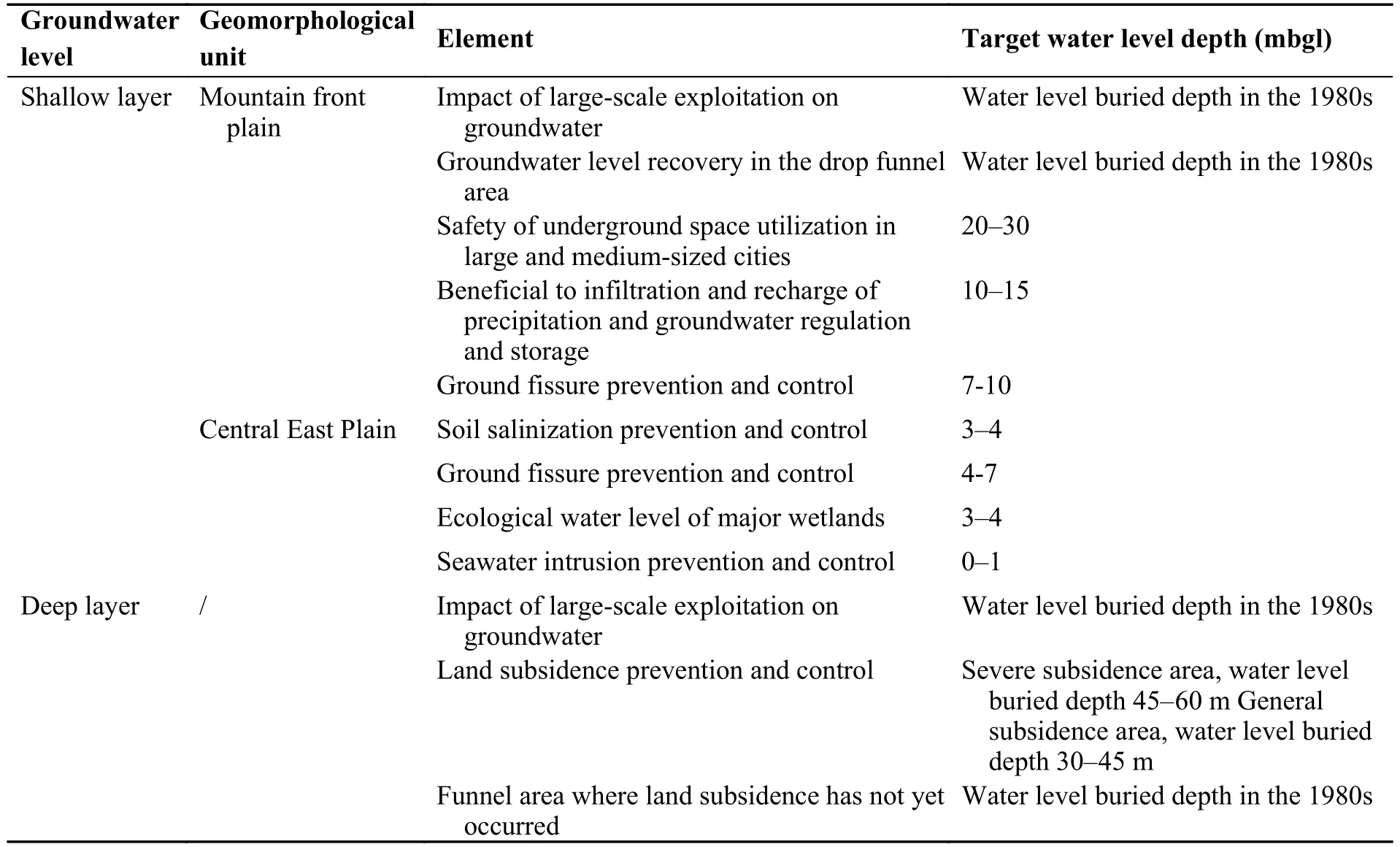
Table 1 Groundwater level recovery threshold index system
Taking into account the factors as soil salinization, precipitation infiltration, groundwater recharge, groundwater flow and storage, the extent of shallow groundwater depression cone, urban underground space security, ground fracturing, wetland biodiversity, seawater intrusion, etc, the shallow groundwater level in the western mountain front area should be controlled between 15-30 m, and 20-30 m in the urban areas of large and mediumsized cities. As regard to favorable water levels,10-15 mbgl is an ideal depth range for mainta-ining effective recharge, flow and storage, 7-10 m for ground fracturing prevention and control, 3-10 m for soil salinization prevention and control in the central-eastern region, 1-3 m for wetland ecological diversity maintenance, and less than 1 m for seawater intrusion prevention and control.
With respect to deep groundwater, emphasis should be placed on the mitigations of land subsidence, adverse evolution of groundwater depression cone duo to over draft, renewal measures of the resources and other factors. As a result, the water levels should be controlled in the range of 45-60 m deep in severe land subsidence areas. For light and even moderate land subsidence areas,they can be controlled within the depth range of 30-45 m and 10-30 m for mountain front plain(Fig. 3).
4 Evolution of groundwater flow field over-exploitation
4.1 Groundwater level
The shallow groundwater level in the mountain front plain area declined rapidly by the early 21st century. After 2014, along with the operation of the SNWD Project and application of measures for controlling groundwater over-exploitation, the trend of the shallow water level decline in the major cities in mountain front plain was eased, resulting in a water level rebounding in the urban areas. However, in rural and agricultural areas, the water level has kept on dropping, with a largest decline of 60-70 m happening in the area of the Baoding-Shijiazhuang-Xingtai alluvial fan margin located in the front of Taihang Mountain. The shallow groundwater level in the central-eastern plain experiences natural fluctuations (Fig. 4).
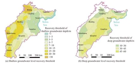
Fig. 3 Groundwater level recovery threshold in the Beijing-Tianjin-Hebei Plain
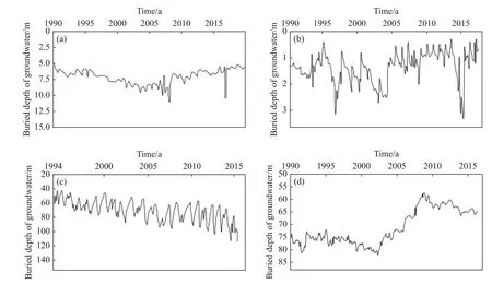
Fig. 4 Hydrograph for groundwater in the plain of Haihe River Basin (Yang et al. 2021a)
In the mountain front plain, the Chaobai River alluvial fan, for example, was affected by groundwater exploitation and mountain reservoir storage before 2007, and as a result the shallow groundwater level dropped by 0.15 m per year. In 2008-2012, the application of some water-saving measures, such as the alluvial fan water only supplied for emergency purpose, the promotion of waterwise agriculture and the use of recycled water and rainwater, slightly improved the groundwater level recovery with a rise rate of 0.4 m per year. Since 2014, the rate has been maintained at the level of 0.6 m per annum, with water supply of the Southto-North Water Transfer Middle Route Project, the continuous promotion of groundwater over-exploitation control and ecological water replenishment measures carried out in the Chaobai River alluvial fan area. Shallow groundwater in the centraleastern plain is mainly brackish and semi-saline,with a low the exploitation level, so that the water level there is in a natural fluctuation state. Taking the shallow monitoring wells in urban Cangzhou as an example, only in 1996-2002, the water level showed a decreasing trend due to low precipitation,and the groundwater level shows natural fluctuations for the rest of the years (Yang et al. 2021b).
From the year of 1980 to 2005, deep groundwater level in the agricultural area decreased at a rate of 1-3 m/a, and that of Hengshui and Cangzhou in the central-eastern part of the plain decreased at the greatest rate of 3-4 m/a. From 2005 to 2020, the water level of the agricultural area in the central-eastern part of the plain kept on a rapid decline due to the influence of agricultural water exploitation, but the decreasing rate was reduced to 2-4 m/a. Deep groundwater level in the urban area has rebounded since the implementation of over-exploitation control. In Jing County of Hengshui and urban area in Cangzhou, for instance, the shallow groundwater in Jing County is mainly brackish and semi-saline water. As a result,the agricultural irrigation has heavily depended on groundwater resources which have long been over drafted from the deep aquifers without effective remediation measures towards the resources overexploitation, further resulting in a water level drop rate of 2 m per annum. As the private wells in Cangzhou urban areas have been closed since 2005, water levels of the deep aquifers are on the rise.
4.2 Change of regional groundwater flow field
In the BTHP area, shallow groundwater levels have undergone a different evolution patterns in different regions. In the west, the water levels have rapidly declined from the 1980s to the year of 2020, while in the major urban areas in the western mountain front they have ceased rising after the launch of the South-to-North Water Transfer Project in 2014. The water level in the east is in a state of natural fluctuation.
The western mountain front plain is main locality for the extraction of shallow groundwater,where the water level continuously and rapidly decreased before 2014, with a cumulative drawdown of 25-60 m and a largest drop rate of 2 m/a at Shijiazhuang-Xingtai. Since the SNWD project was in place in 2014, the water levels in urban areas like Beijing, Baoding, Shijiazhuang, Xingtai,and Handan have significantly rebounded, of which the recovery rate in the center of Beijing is 3 m/a.but they are still on a rapid decline in the city peripheries, with a cumulative drawdown of 10-30 m and a decline rate of more than 3 m/a (Fig. 5). In the past 15 years, the shallow groundwater in the central-eastern part of the plain has been mainly brackish and saline water, with very low level of exploitation, so the water level is generally in a state of natural fluctuation. Rainfall changes and agricultural irrigation are the main reasons for the dynamic changes of water level in this area.
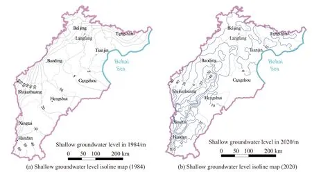
Fig. 5 Isoline map of shallow groundwater level in the Beijing-Tianjin-Hebei Plain area
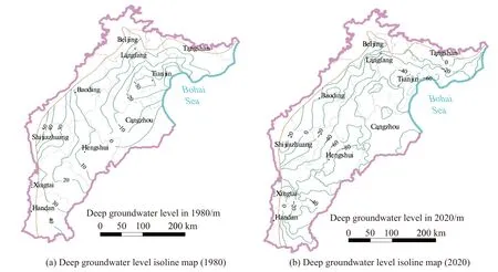
Fig. 6 Isoline map of deep groundwater level in Beijing-Tianjin-Hebei Plain area
The deep groundwater level in the Beijing-Tianjin-Hebei Plain area, from the 1980s to 2020,showed an overall declining trend (Fig. 6), with the largest decline in the central-eastern region. After 2014, deep groundwater level in urban areas and agricultural areas showed a differentiated development, with the groundwater level in urban areas rebounding significantly and that of the surrounding agricultural areas still showing a rapid decline.From the 1980s to 2014, the deep groundwater level of Hengshui, Cangzhou and southern Tianjin in the central-eastern plain declined the most in the region, with a cumulative decline of 40-80 m and an average decline rate of 1.5 m/a. After 2014,with the comprehensive treatment of groundwater over-exploitation and the promotion of Southto-North Water Transfer Project, the deep groundwater level in urban and agricultural areas developed differently. Self-provided wells were shut down and water replacement was carried out to reduce the amount of deep groundwater exploited in urban areas of Hengshui, Cangzhou and Tianjin.The deep groundwater level was rebounding there,among which that in Tianjin has the largest and fastest rebounding rate, reaching 4 m/a. Due to the lack of replacement of water sources in agricultural areas, agriculture industry still exploits deep groundwater on a large scale. With deep groundwater exploited for agricultural irrigation, the water level is still on a rapid decline, and the decline rate exceeds that of the previous phase in 2014, which reaches 2-5 m/a.
4.3 Groundwater storage
According to Fei et al. (2015) and Wang et al.(2014), there is a correlation between the groundwater storage and the degree of groundwater exploitation and utilization in the BTHP area.Shallow groundwater storage changes are correlated with the rise or fall of shallow groundwater level; and the storage increases when the shallow groundwater level rises and decreases as the level falls. The deep groundwater storage includes two parts, the water from the deep aquifer induced by the change in groundwater level and the amount of compression releasing water from clay soil triggered by water level decrease. The flexible water release volume is the product of water level changes and the elastic release coefficient of the confined aquifer. Due to intrinsic property of irreversible compressed deformation of clay soil, the reduction of deep groundwater storage caused by compressed water release will not be recoverable.
Based on the water amount change due to the change in water levels, groundwater storage is hence evaluated. Evaluation result show that the shallow groundwater storage decreased by 597×108m3from 1984 to 2020, with the largest decrease occurred in Baoding-Shijiazhuang-Xingtai-Handan area. Since the 1980s, large-scale exploitation of shallow groundwater in the BTHP for agricultural irrigation has resulted in a rapid decrease in shallow groundwater storage. The accumulated reduction in mountain front plain is about 20×104m3/km2, among which in the area of Baoding-Shijiazhuang-Xingtai-Handan the accumulated storage reduction reaches 100×104-300×104m3/km2. In some areas around Shijiazhuang the figure is larger than 300×104m3/km2.
Based on the deep groundwater level isolines with data derived in 1984 and 2020, respectively,the water level variations are analyzed. Considering elastic release coefficient of the deep aquifers and land subsidence data, the changes of deep groundwater storage is evaluated. the amount of deep groundwater storage has decreased significantly because of increasing demand of water resources due to the rapid growth in urban population and rural agriculture. According to the evaluation,the accumulated decrease of the resources storage from 1980 to 2020 is 545×108m3, with a largest resources decrease occurs in the area of Tianjin-Cangzhou-Hengshui. The overall reductions of the deep water are 0-50×104m3/km2and 50×104-100×104m3/km2, respectively, in the mountain front plain and central-eastern plain. Among them the reduction figure in the areas around Tianjin, Cangzhou and Hengshui is 100×104-200×104m3/km2,while in some areas around Tianjin it is greater than 200×104m3/km2(Fig. 7).

Fig. 7 Groundwater storage variables in the Beijing-Tianjin-Hebei Plain
4.4 Suggestions and measures towards groundwater over-exploitation remediation
The threshold for groundwater level recovery is defined on the basis of groundwater flow field characteristics with data derived from in the early 1980s. The analysis of flow field was performed with the intention of delineating the changes in groundwater level and storage quantity from the year of 1980 to 2020, taking multiple factors as the above discussed in account. In order to achieve the objectives of groundwater level fully recovered in 2040 and a balance between the resources extraction and replenishment mostly met in 2025, the strategy towards controlling groundwater over-exploitation and mitigating associated environmental problems in Beijing, Tianjin and Hebei province has been drawn, in accordance with the Action Plan for Groundwater over Exploitation Remediation in North China.
In order to effectively mitigate the problems in relation to aquifer overdraft over the BTHP area, it is necessary for the measures as exploitation control, groundwater recharge and water replacement to be simultaneously implemented to maintain a balance between input and output of the resources.And it is suggested that the measures for the shallow aquifers include: (1) The amount of water exploited should be reduced by 2×10⁸m3per year from 2022 to 2025 (Fig. 8), while a river ecological replenishment amount of 28.58×10⁸m3/a should be achieved through South-to-North Water Transfer Project to reach the balance; (2) exploitation control or surface water replacement of 25.77×10⁸m3/a needs to be made from 2026 to 2040 with water recharge of 33.51×10⁸m3/a for river ecology through the SNWD project.
The ideal locations for groundwater recharge are Hutuo River-Sha River alluvial fan area, Yongding River alluvial fan, Chaobai River alluvial fan,Juma River alluvial fan and Fuyang River alluvial fan. The vadose zones of the above areas are mainly sand and gravel, with a strong infiltration capacity, and they are close to the infrastructure of the SNWD Project, which can also guarantee ecological recharge water sources. In 2018, a total of 6.25×10⁸m3water was recharged to the BTHP area via the SNWD project. Moreover, in September 2018, the SNWD Project commenced to provide ecological water to the BTHP area via Juma River, Hutuo River and Fuyang River. Since then the ecological recharge quantity has been increased year by year, with a total of 44.2×10⁸m3in 2020. According to groundwater monitoring, in the external water recharge area, the average rise in water level has so far reached 1.47 m in the mountain front areas which have a total areal size of 16 200 km2, accounting for 18.2% of the BTHP area.
A comprehensive strategy of multi-water source recharge or replacement to control deep groundwater over-exploitation has been adopted, in which the water level thresholds will gradually be reached through effectively managing the balance between exploitation and replenishment, particularly in the farming area where massive deep groundwater has been extracted for irrigation purpose.Firstly, in the central and eastern plains where agricultural activities have heavily depended on groundwater resources, the utilization of shallow brackish and semi-saline water should be maximized up to 21×108m3/a, by using the brackish water treatment technology titled replacing fresh water with salty water which has been applied in the fields of agriculture. Secondly, the second phase of the middleeast route of the SNWD Project will strengthen the planning and construction of the irrigation canal network from the main canal to the fields which may gradually replace the groundwater utilization for agricultural irrigation so as to control groundwater exploitation. It is hence suggested for the deep groundwater over-exploitation remediation that:(1) An annual extraction amount of about 2.24×10⁸m3needs to be gradually reduced from 2022 to 2025 (Fig. 9); (2) from 2026 to 2040, in the centraleastern plain the brackish water replacement for the deep groundwater will reach 2.82×10⁸m3/a and the surface water replacement of 7.86×10⁸m3/a, to achieve deep groundwater level recovery. Considering that with the progress of water resource utilization technology, the replacement of deep fresh water with shallow brackish water is mainly promoted in Cangzhou and Hengshui in the centraleastern plain.

Fig. 8 Suggested treatment map of shallow groundwater over-exploitation in the Beijing-Tianjin-Hebei Plain
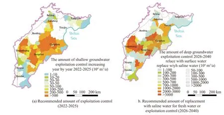
Fig. 9 Suggested treatment map of deep groundwater over-exploitation in the Beijing-Tianjin-Hebei Plain
According to the predicted groundwater flow field in 2040 based on the numerical model, by 2040, at the boundary of shallow groundwater depression cone located in the mountain front plain,the groundwater levels will rise from 20 mbgl to about 5 mbgl with a rise rate of 1.32 m/a. This suggests that the shallow groundwater depression cone basically disappears. At the boundary of deep groundwater depression cone in the central-eastern plain, the groundwater level will rise from 60 mbgl to about 10 mbgl with a rise rate of 2.63 m/a.
5 Conclusions and Suggestions
To support the comprehensive control of groundwater overexploitation in Beijing-Tianjin-Hebei Plain (BTHP) and to solve the environmental geological problems due to the resources over-exploitation, this paper establishes the first regional groundwater level recovery threshold index system based on the study of groundwater level and groundwater storage evolutions. In order to achieve a balance between groundwater exploitation and recharge, and water level recovery. Refined measures to the groundwater overexploitation are proposed through the application of groundwater numerical simulation methods.
(1). In the past 40 years, the shallow groundwater level in the BTHP area has continued to decline rapidly in the mountain front area, with a total drawdown of 25-60 m and a cumulative storage reduction of 597×108m3The deep groundwater level has also declined, with a total drawdown of 40-80 m and a cumulative storage reduction of 545×108m3in the central-eastern region.
(2). The water level thresholds for shallow and deep aquifer systems are proposed, respectively, in different plain regions such as: 15-30 mbgl for shallow groundwater in the depression cone areas in the western mountain front plain, 20-30 mbgl in large and medium-sized urban areas, 10-15 mbgl in groundwater preservation areas, 3-10 mbgl in central-eastern soil salinization areas, 3-4 mbgl in wetland areas, less than 1 mbgl in seawater intrusion control areas, 45-60 mbgl for deep groundwater level in serious land subsidence areas, and 30-45 mbgl in general subsidence areas.
(3). Exploitation control and water recharge and water replacement measures need to be implemented simultaneously for shallow groundwater over-exploitation treatment. An annual exploitation quantity of 2×10⁸m3needs to be reduced and a recharge quantity of 28.58×10⁸m3/a for river ecology so as to reach a balance between the exploitation and replenishment in 2025; further reduction and surface water replacement of 25.77×10⁸m3/a need to be made from 2026 to 2040 with a recharge volume of 33.51×10⁸m3/a for river ecology,so that the target water level will gradually be reached.
(4). A comprehensive strategy of water source replacement and groundwater exploitation control is adopted for deep groundwater over-exploitation treatment. The exploitation amount of 2.24×10⁸m3needs to be reduced gradually so as to reach a balance between exploitation and replenishment in 2025. Brackish water with a volume of 2.82×10⁸m3/a will necessarily be used to replace the deep groundwater from 2026 to 2040, with a surface water source replacement quantity of 7.86×10⁸m3/a, so that target water level will gradually be reached.
Acknowledgements
This research was funded by Geological survey project of China Geological Survey (DD20190336,DD20221752). The authors give many thanks to every reviewer who provided many invaluable suggestions for revising this paper.
杂志排行
地下水科学与工程(英文版)的其它文章
- Numerical simulation of operation performance on production and injection of a double well geothermal system in Kailu Basin, Inner Mongolia
- Spatial confirmation of termite mounds as Bio-geo indicator for groundwater occurrences using ground magnetic survey: A case study from Perambalur Region of Tamil Nadu, India
- Research on the characteristics and influencing factors of terrestrial heat flow in Guizhou Province
- Comparative analysis of bacterial contamination in tap and groundwater: A case study on water quality of Quetta City, an arid zone in Pakistan
- Holistic approach of GIS based Multi-Criteria Decision Analysis (MCDA)and WetSpass models to evaluate groundwater potential in Gelana watershed of Ethiopia
- Genetic model and exploration target area of geothermal resources in Hongtang Area, Xiamen, China
