Determination of soybean yield gap and potential production in Iran using modeling approach and GIS
2021-01-18AlirezaNEHBANDANIAfshinSoltANIAliRAHEmIKARIzAKI
Alireza NEHBANDANI,Afshin SoltANI,Ali RAHEmI-KARIzAKI
2,Amir DADRASI3,Faranak NouRBAKHSH4
1 Department of Plant Production,Gorgan University of Agricultural Sciences and Natural Resources,Gorgan 4918943464,Iran 2 Department of Plant Production,Gonbad Kavoos University,Gonbad Kavoos 4971799151,Iran
3 Department of Agronomy,Agricultural Science,Vali-e-Asr University of Rafsanjan,Kerman 7718897111,Iran
4 SWEP Analytical Laboratories,Melbourne,Victoria 3173,Australia
Abstract Increasing crop production is necessary to maintain food security for the growing global population. Reducing the gap between actual and potential yield is one of the important ways to increase yield per unit area. Potential yield and the yield gap of soybean were determined for Golestan Province,Iran,using Soybean Simulation Model (SSM-iCrop2) and Geographical Information System (GIS). Information from 24 weather stations and soil data of the region were used. Yield gap and production gap were calculated at county and province levels. The average actual yield of soybean in this province was 2.28 t ha–1 while the province’s potential yield was 4.73 t ha–1,so the yield gap was estimated 2.44 t ha–1. Thus,there is a great potential for increasing soybean yield in Golestan,which is possible through improving crop management of soybean in farmers’ fields. The average water productivity of soybean was estimated to be 0.81 kg m–3. Spatial distribution of water productivity in soybean farms showed that the highest and the lowest water productivities (0.99 and 0.44 kg m–3) were in western and eastern regions of the province,respectively,in accordance to vapour pressure deficit. It was concluded that soybean production in the province could increase by 66% (from 109 970 to 182 170 tons) if 80% of the current yield gap could be removed.
Keywords:crop area,oilseed,production gap,soybean,yield gap
1.Introduction
Soybean (Glycine max) is one of the most important oilseed crops cultivated in the world. Soybean plant area and production in Iran are about 66 000 hectares and 151 000 tons,respectively,based on statistics from 2013 to 2017 (MAJ 2018). Soybean currently covers more than 50 000 hectares of agricultural lands in Golestan Province and is ranked as the top soybean-producing area of Iran with about 74%of total soybean production. Soybean production in Iran does not meet the domestic needs so that every year about 2.0 to 2.5 million tons soybean meal is imported which costs about 1.5 billion USD (2012 prices) for Iran (IOEIA 2015). Iran also imports soybean oil. In 2013,about 800 000 tonnes soybean oil with a worth of 960 million USD has been imported (FAO 2013). Therefore,there is a pressing need to increase the yield and production of oilseeds in Iran including soybean.
One approach to increase crop yield and food supply is to evaluate the yield gap which is the difference between potential and actual yield (Egli and Hatfield 2014). One of the methods to estimate the yield gap is the agroecological zoning based on interpolation methods. In this method,based on actual weather data,soil information and field management,the potential yield is estimated by a crop growth simulation model. Then,using one of the interpolation methods (Kriging,Co-Kriging,IDW1IDW,inverse sistance weighting.,LPI2LPI,local polynomial interpolation.),ArcGIS Software can be used to determine the yield in all parts of the crop area (Hagan and West 2006).
Various studies have been conducted on soybean yield gap in the world so far. Bhatiaet al.(2008) examined the soybean yield gap using the CROPGRO-Soybean model in India. The results showed that the average potential yield of soybean under irrigation and water-limited conditions was 3.02 and 2.17 t ha–1,respectively in India. Singhet al.(2001) in 11 studied areas in India showed that the potential yield of soybean varied in a range between 1249 and 3.05 t ha–1and the actual yield ranged between 0.57 and 1.12 t ha–1with a yield gap between 0.24 and 1.96 t ha–1(19 to 65% of potential yield). For northeastern Thailand,rice yield gap was determined from 1.37 to 2.32 t ha–1(38 to 65% of the potential yield),in upland rice from 0.18 to 0.27 t ha–1(11 to 18%),in maize from 1.21 to 3.18 t ha–1(25 to 67%),in soybean from 0.63 to 0.94 t ha–1(32 to 49%),and in peanut from 0.19 to 0.57 t ha–1(11 to 33%). Merloset al.(2015) studied the yield gap of maize,wheat and soybean in Argentina. Based on their results,yield gap in rainfed maize and wheat was 41% and it was 32% for irrigated soybean.They indicated that if the yield gap could be closed to 20%of the potential yield,the yield of soybean,wheat and maize would reach 7.4,5.2 and 9.2 t ha–1.
Favourable weather condition has made Golestan Province to be one of highly intensified crop production centers of Iran. Golestan Province is the top producing province for oilseed crops including soybean (MAJ 2016).The lack of zoning and identification of the province’s potential for a variety of agricultural activities based on the ecological characteristics of the region have caused destruction of the environment and natural resources,pollution of water and soil resources,soil salinity,reduction of groundwater resource,and unstable agricultural systems in the province (Kazemiet al.2016). Considering the importance of soybean production,as well as the necessity for quantifying the yield gap to assess the possibility of achieving higher yields,this study was conducted with the aim of quantifying soybean yield gap and potential yield using the SSM-iCrop2 Model (Soltani and Sinclair 2011)and the GIS approach under irrigated lands of the province.
2.Data and methods
This study was conducted in Golestan Province which is located in northeast of Iran with the coordinates of 35´36°to 38°8´N and 51´53° to 22´56°E. This province has an area of 20 438 km2with 14 counties; soybean is grown in all the counties except for Maraveh-Tappeh. Fig.1 shows the distribution of irrigated land in Golestan and the position of selected weather stations.
2.1.the model
To estimate soybean potential yield,the Simple Simulation Model (SSM-iCrop2) was applied (Soltaniet al.2013,2020).Yield potential (Yp) is defined as the yield of an adapted crop cultivar as determined by temperature,carbon dioxide and solar radiation and genetic traits that govern length of growing period,light interception by the crop canopy and its conversion to biomass,and partition of biomass to the harvestable organs (Grassiniet al.2015). The SSM-iCrop2 calculates soybean phenology and grain yield using daily weather data(the minimum and maximum temperatures,solar radiation and rainfall),and utilizes sub-models for phenological development,leaf development and senescence,dry mass production and partitioning,yield formation and soil water balance. In this model,the phenological stages are predicted based on thermal time adjusted for soil moisture conditions (Soltani and Sinclair 2011). The model predicts the number of the days from sowing to emergence,beginning and termination of seed growth,the beginning of leaves senescence,and maturity (Soltaniet al.1999). Leaf area development and senescence are linked to development stage of crop that itself is a function of temperature. Dry mass production is predicted using the radiation use efficiency(RUE) concept. The radiation interception is determined using crop leaf area index (LAI) and crop canopy extinction coefficient for PAR (KPAR) according to the Beyer-Buger-Lambert law (Sinclair 2006). The SSM Model for soybean was parameterized and evaluated for the important soybean producing provinces of Iran including Golestan and the results were satisfactory (Nehbandani 2018). Model parameters are shown in Table 1.
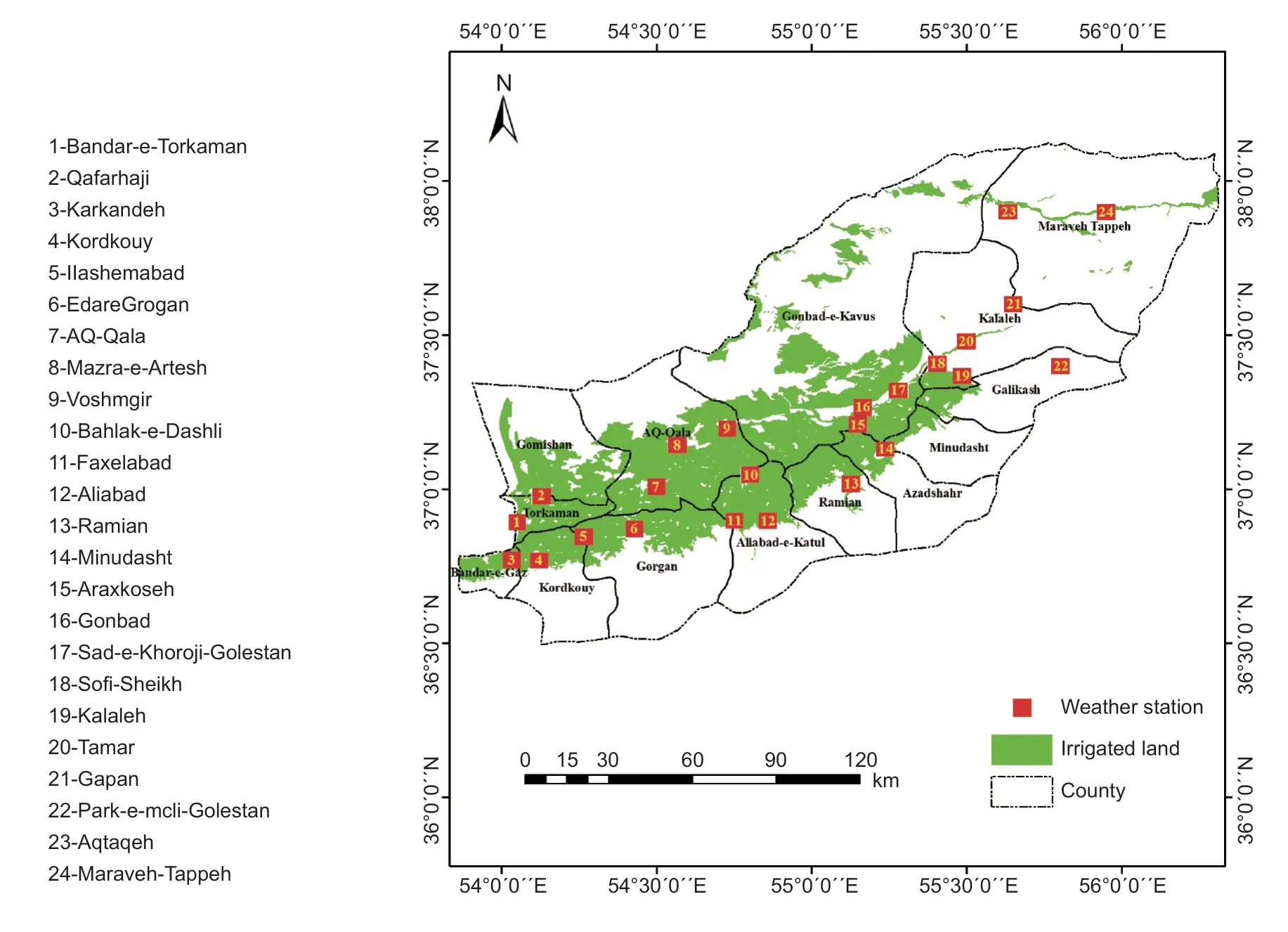
Fig.1 Location of the weather stations and distribution of irrigated land use in Golestan Province,Iran.
2.2.Data
For this study,long-term daily weather data including the minimum and maximum temperatures,rainfall and daily sunshine hours (Fig.1) was obtained from the Golestan Meteorological Office. Radiation was calculated using WeatherMan Software based on sunshine hours. For simulation,the model needs the date of sowing,cultivation type (irrigated or rainfed) and cultivar. The common rotation in Golestan Province is double cropping of wheat-soybean.Most farmers cultivate soybean early in the summer.Therefore,5 July (176 days of the year) was considered as sowing date for all stations. Irrigation farming was defined in the model which is practiced in the province due to the lack of enough rainfall during soybean growing season in summer. The irrigation timing in the model was when the fraction of available water in the soil drops below 0.5. The common cultivar in region is Katoul (with a growth period of about 150 days) and parameters of this cultivar were used in the model. The soil information is required to run the model. Soil information was obtained from International Food Policy Research Institute (IFPRI)-HarvestChoice HC27 (Koo and Dimes 2013) for the province as indicated in Table 2.
To estimate the yield gap by the interpolation method,weather data from 24 stations were collected from Golestan Meteorological Office (http://portal.golestanmet.ir/). The weather stations were selected in such a way as to provide province-wide coverage with appropriate distribution,as well as the stations within the 14 counties to provide the least error conditions and the highest accuracy in subsequent calculations.
The model was run for each weather station for a period of 10 years from 2005 to 2014 and the potential yield for each station was obtained. Then interpolation (at the provincial level) was performed using Kriging,Co-Kriging,IDW,and LPI in ArcGIS 10.3 softwares. Validity and accuracy of these methods were evaluated by calculation of three evaluation indices,i.e.,root mean square error (RMSE),mean bias error (MBE) and mean absolute error (MAE),and the method with a higher accuracy and the lowest error was selected. To determine the yield gap of each county using the province potential yield map,the average potential yield in eachcounty was calculated using ArcMap Software. Then,the difference between this potential yield and the actual yield(average yield of farmers in each county) was considered as the yield gap.
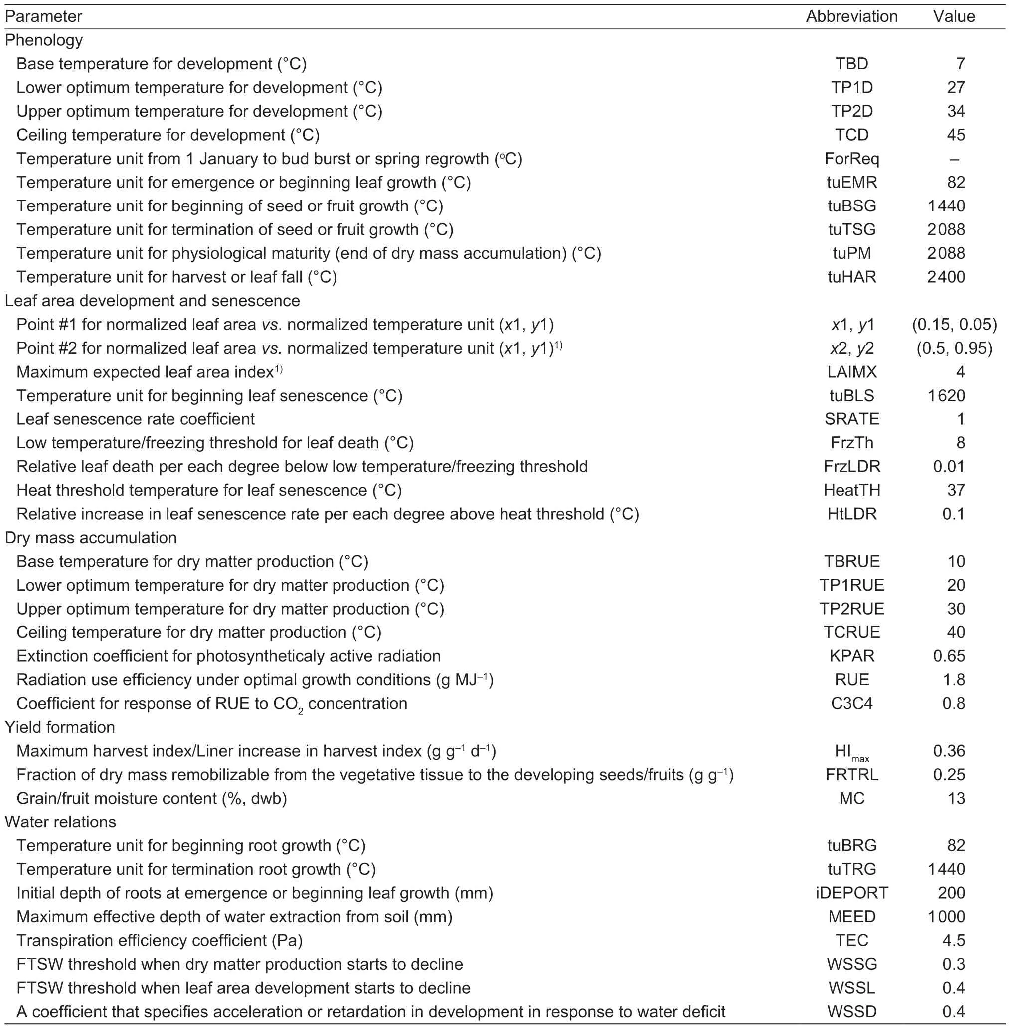
Table 1 Definition of parameters in Simple Simulation Model (SSM-iCrop2) and their estimates for soybean in Iran
To investigate the climatic factors affecting the potential yield of soybean in Golestan Province,solar radiation,the minimum and maximum temperatures and precipitation during the soybean growing season were analyzed over the province using interpolation method in ArcMap.
The production potential of each county was calculated by multiplying the soybean potential yield and the crop area in each county. The production gap was calculated from the difference between the production potential and the actual production of each county.
3.Results
3.1.Potential yield
The results showed that the soybean potential yield in Golestan Province varies between 4.39 and 5.12 t ha–1(Fig.2). Soybean potential yield increased from west to east of the province. The potential yields calculated for weather stations also confirmed the trend. Stations with a yield more than 5 t ha–1,such as Minudasht,Gapan and Tamar are located in the eastern part of the province,while stations with a yield less than 4.5 t ha–1are located in the western part of the province. A regression analysis of potential yieldvs.environmental variables indicated cumulated solar radiation and average minimum temperature during the growing season were the most important factors determining the potential yield (Fig.3). The relationships between potential yield and environmental factors,i.e.,the maximum temperature and rainfall,were not significant (Fig.3). To better illustrate this,cumulated solar radiation and the average minimum temperature during soybean growing season were mapped (Figs.4 and 5). Accumulated solar radiation during soybean growing season in the western part of the province is 2 415 MJ m–2while it is 2 864 MJ m–2in the eastern part (Fig.4). Average minimum temperature in central part of the province was about 16°C whereas it was 20°C in other parts (Fig.5). A comparison of Figs.2,4 and 5 indicated that variation of soybean potential yield was harmonized with the variation of accumulated solar radiation and average minimum temperature during soybean growing season.
3.2.Water productivity
The highest and lowest soybean water productivities (1.09 and 0.64 kg m–3) was found in western and eastern parts of Golestan Province,respectively (Fig.6). The mean value of soybean water productivity over the province was 0.81 kg m–3. Average amount of soybean water productivity rangedbetween 0.6 and 0.9 kg m–3(Irmaket al.2014).

Table 2 The major soils in soybean cultivation areas of Golestan Province,Iran1)
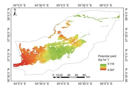
Fig.2 The zoning map of potential yield of soybean in Golestan Province,Iran.
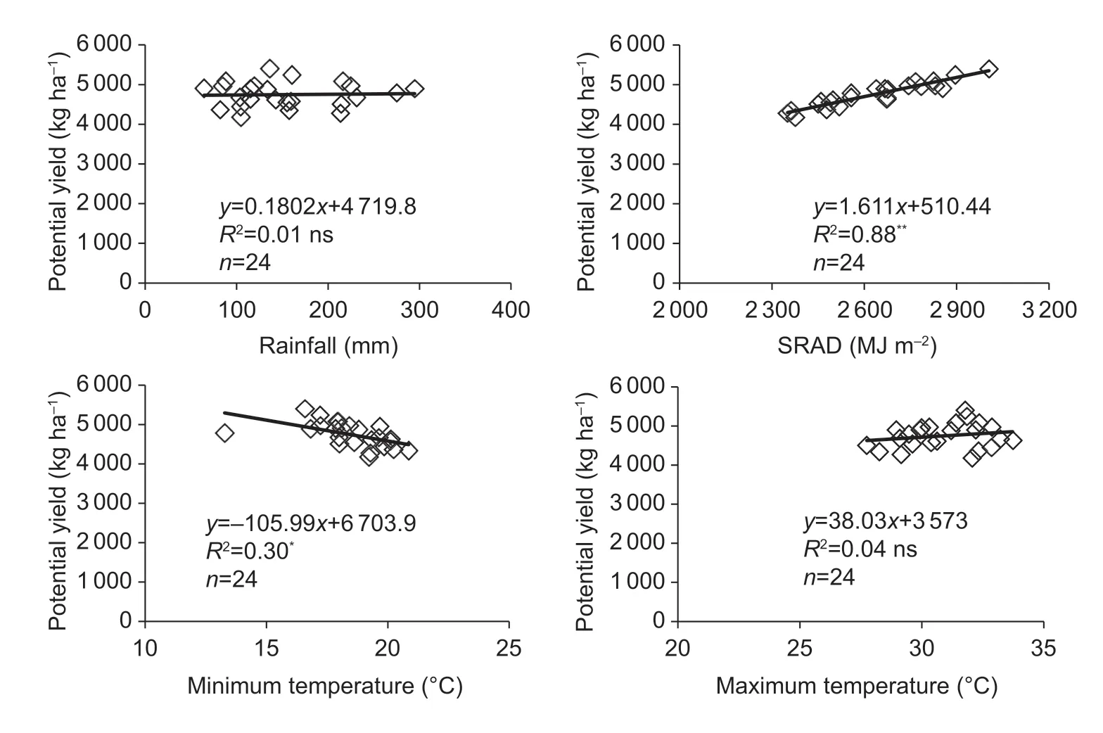
Fig.3 The relationship between potential yield vs.accumulated solar radiation (SRAD),rainfall,maximum and minimum temperatures during the soybean growing season. Each point is average of years (2005 to 2014) for each weather station.
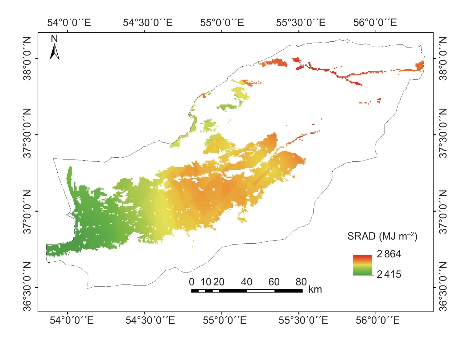
Fig.4 The zoning map of accumulated solar radiation (MJ m–2) during the soybean growing season in Golestan Province,Iran.
Assessment of average maximum temperature and total precipitation in soybean growing season showed that the eastern part of Golestan Province has higher average maximum temperature and lower amount of precipitation compared to the western part (Figs.7 and 8).This combination reduces air humidity in the eastern part of the province so that average vapour-pressure deficit(VPD) during soybean growing season is higher in the eastern part compared to the western part of the province(Fig.9). Several studies have proved that the relationship between water productivity and VPD is negative (Abbateet al.2004; Rodriguez and Sadras 2007). So,lower water productivity is related to higher VPD in the eastern part of the province. For instance,Gapan in the east of the province had the lowest water productivity (0.61 kg m–3) and the highest VPD (2.24 kPa),evapotranspiration (886 mm) and net irrigation requirement (714 mm) while the Bandar-e-Torkaman in the west of the province had the highest water productivity (1.19 kg m–3) and the lowest VPD (0.89 kPa),evapotranspiration (350 mm) and net irrigation requirement(186 mm) (Table 3).
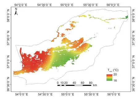
Fig.5 The zoning map of average minimum temperature (Tmin,°C) during the soybean growing season in Golestan Province,Iran.
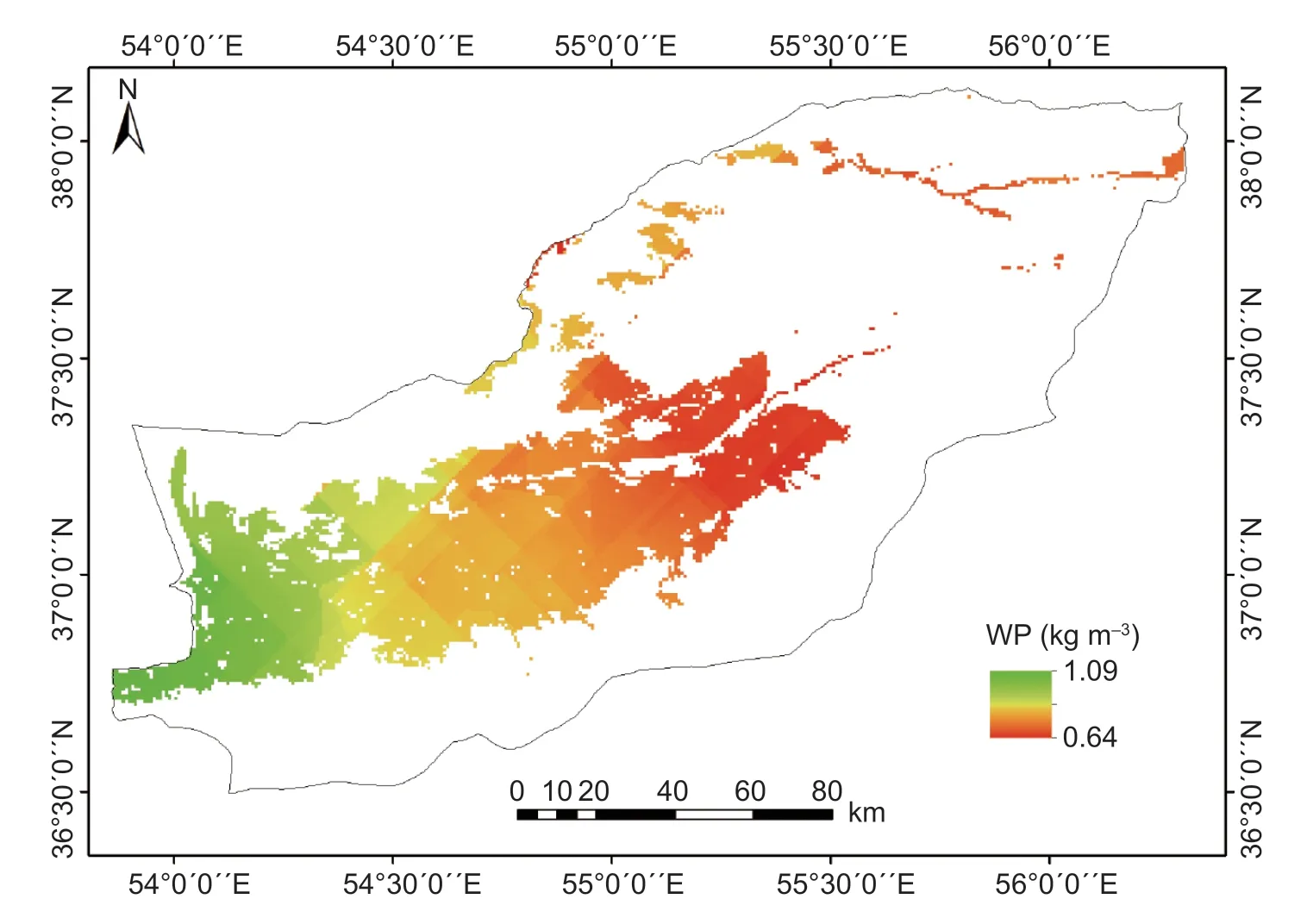
Fig.6 The zoning map of water productivity (WP,kg m–3) of soybean in Golestan Province,Iran.
3.3.Yield gap
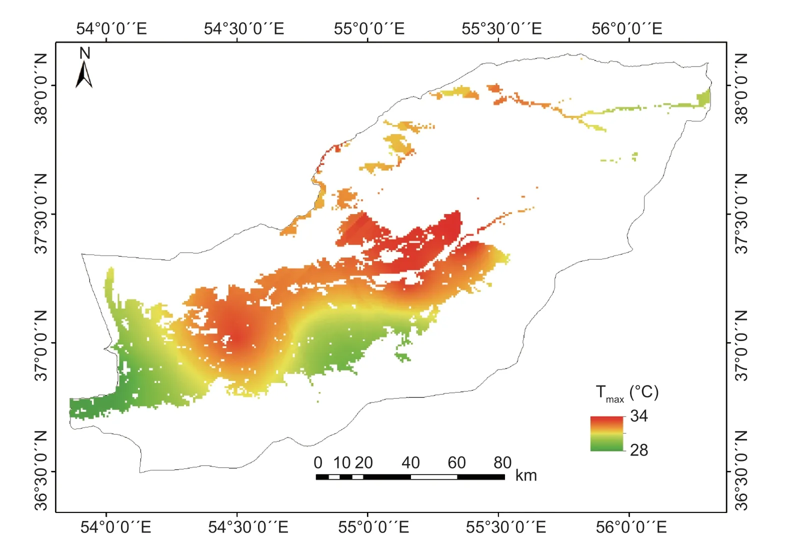
Fig.7 The zoning map of average maximum temperature (Tmax,°C) during the soybean growing season in Golestan Province,Iran.
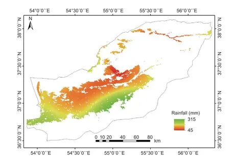
Fig.8 The zoning map of accumulated rainfall (mm) during the soybean growing season in Golestan Province,Iran.
Soybean actual yield and yield gap in Golestan Province were shown in Fig.10 and Table 4. The highest and the lowest potential yields were found in Ramian (4.86 t ha–1)and Bandar-e-Gaz (4.43 t ha–1) (Table 4). Average soybean potential yield in Golestan Province was 4.73 t ha–1. The highest and the lowest yield gaps were found in Gonbad-e-Kavus (2.97 t ha–1) and Gorgan (2.18 t ha–1) (Table 4). The average yield gap was 2.44 t ha–1(Table 4).
3.4.Production gap
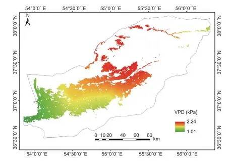
Fig.9 The zoning map of vapour-pressure deficit (VPD) (kPa) of soybean in Golestan Province,Iran.
The potential production and production gap in the Golestan were shown in Fig.9 and Table 5. The highest soybean crop area and potential production were found in Gorgan and the lowest were observed in Gomishan County(Fig.11). Soybean potential production was found to be 227 712 tonnes over the province. The largest and the lowest production gaps were in Gorgan (37 313 tonnes)and Gomishan (31 tonnes) counties,respectively. Soybean production gap in Golestan Province was estimated to be 117 742 tonnes.
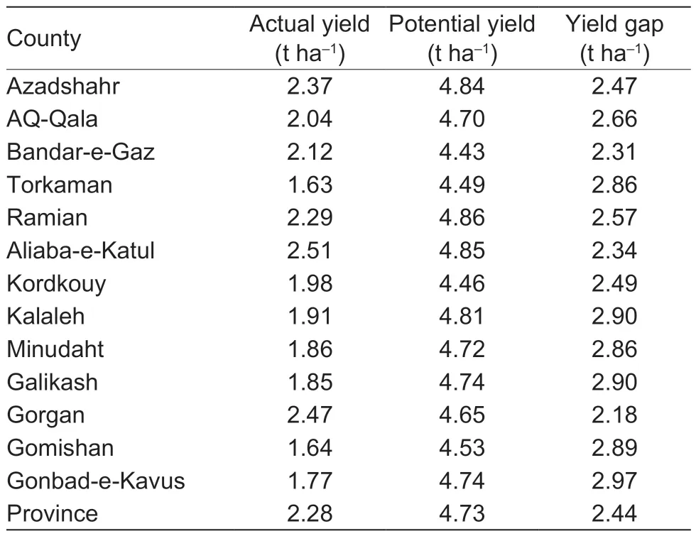
Table 4 Actual and potential yield and yield gap of soybean in counties of Golestan Province,Iran (2005–2014)
4.Discussion
The relationship between potential yield and cumulative solar radiation was positive but the relationship between potential yield and the average minimum temperature was negative. The reason is that higher temperatures accelerate soybean development and the crop cycle becomes shorter,thus,the crop will have less time to intercept solar radiation which results in lower potential yield. This is supported by Hatfield and Prueger (2015)for several different typical species of grain production which reflects the importance of temperature on growth and development of plants. Solar radiation is known the primary limiting factor of crop yield under irrigated conditions (Garbulskyet al.2010).
In the conditions of non-limited water and nutrients and in the absence of pests or diseases,plant production often shows a linear relationship with the amount of accumulated incident or intercepted solar radiation (Tohidiet al.2012).The dry matter production is directly related to the amount of radiation absorbed by the canopy (Koochekiet al.2009). Therefore,one of the approaches for achieving high production is to provide favourable conditions for a high radiation interception,for example,using suitable plant density and sowing date (Lindquistet al.2005).Nevertheless,soybean yield gap is higher in eastern part of province than in western part. One reason for this higher gap is lower actual yield in eastern parts of Golestan Province due to a disorder in soybean crop by which the crop produces very few or no pods and hence remains green until the end of the season. The cause(s) of the disorder is (are) not known clearly so far. Based on 2015 report,about 39% of soybean farms in Golestan Province were affected by this disorder(Faraji and Raeise 2015). In addition,the lower actual yield in northern part of the province may be due to soil salinity in the region. Inversely,in southern part of the province,due to favourable soil and environmental conditions (especially low VPD) for soybean yield gaps are smaller.
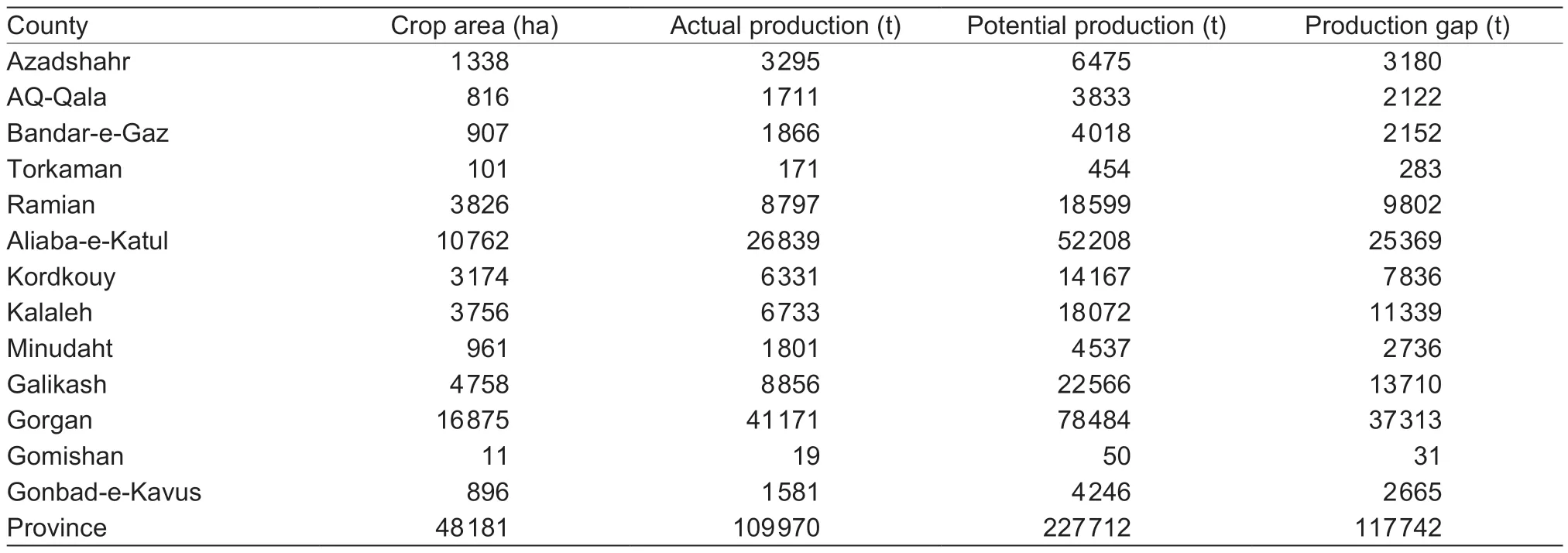
Table 5 Crop area,actual and potential production and production gap of soybean in counties of Golestan Province,Iran (2005–2014)
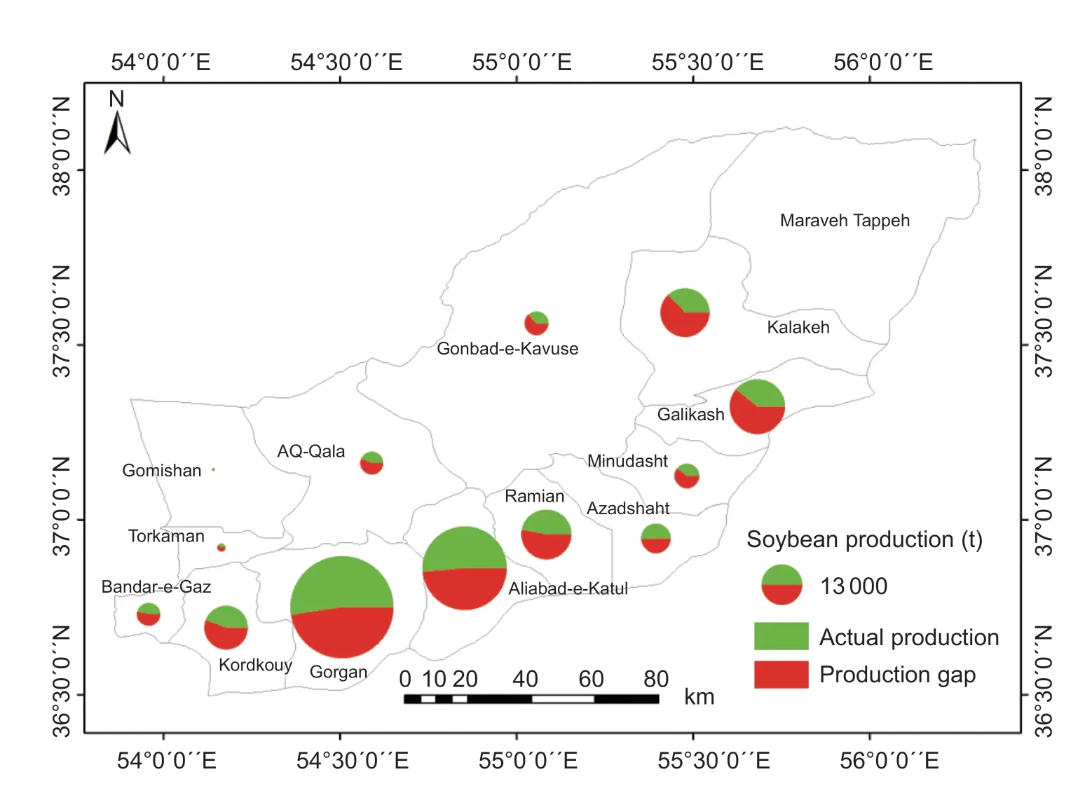
Fig.11 The maps of potential and actual production and production gap of soybean in counties of Golestan Province,Iran. Actual production is in green,production gap is in red and the circle area indicated potential production.
With respect to water productivity,the highest and the lowest soybean water productivity were observed in western and eastern regions of Golestan Province,respectively.Water productivity variation in the province was related to the VPD variation. Water productivity is negatively correlated to VPD (Abbate and Cantarero 2004; Rodriguez and Sadras 2007). VPD is an index of dryness of the environment and the evaporative capacity of the air (Allenet al.1998; Sadok and Sinclair 2009). To obtain higher yields in areas with high VPD,crops need to consume more water,which leads to decline in water use efficiency,as is happens in eastern part of Golestan Province.
5.Conclusion
Golestan is main soybean producing area of Iran. The average actual yield of soybean in the Golestan Province was 2.28 t ha–1and the province’s potential yield was 4.73 t ha–1so the yield gap was estimated 2.44 t ha–1. Average actual production of soybean in this province is 109 970 t and the province’s potential production was estimated to be 227 712 t so the production gap was estimated 117 742 t.The results of this study showed that there are several factors affecting the potential yield,actual yield and yield gap of soybean in the Golestan Province. Soybean water productivity was under influence of factors including solar radiation,the minimum and maximum temperatures and rainfall during the growing season. In regions with high accumulated solar radiation during the growing season,the actual and potential yields were higher,whereas in areas with low solar radiation,actual and potential yields were lower. Water productivity was lower in areas with high solar radiation and potential yield,which could be due to the higher amount of water consumption in these areas than the areas with less solar radiation. The next step after determining the potential yield and yield gap would be a field study of management factors and reasons that cause the yield gap in soybean in Golestan Province,Iran.
杂志排行
Journal of Integrative Agriculture的其它文章
- Yield gap and resource utilization efficiency of three major food crops in the world -A review
- Reducing maize yield gap by matching plant density and solar radiation
- Cultivar selection can increase yield potential and resource use efficiency of spring maize to adapt to climate change in Northeast China
- Effects of different agricultural treatments on narrowing winter wheat yield gap and nitrogen use efficiency in China
- Developing a process-based and remote sensing driven crop yield model for maize (PRYM–Maize) and its validation over the Northeast China Plain
- Delineating the rice crop activities in Northeast China through regional parametric synthesis using satellite remote sensing timeseries data from 2000 to 2015
