Geological factors controlling deep geothermal anomalies in the Qianjiaying Mine,China
2020-12-20WenbinYangShengboHanWuLi
Wenbin Yang,Shengbo Han,Wu Li
Key Laboratory of Coalbed Methane Resource & Reservoir Formation Process,Ministry of Education,China University of Mining and Technology,Xuzhou 221008,China
ABSTRACT Here,the geological factors controlling deep geothermal anomalies in mines were studied based on the geotemperature,lithologic thermal conductivity,and related geological data collected from the Qianjiaying Mine,China.A simulation of the change in magma waste heat,conducted using the ANSYS Workbench,revealed the distribution characteristics of geothermal anomalies in this mine and the corresponding geological control factors.The results revealed the following points.(1)First-degree heat hazard level(temperature=31–37 ℃)occurred in the central and southwestern parts of the mine at an~600-m depth,while second-degree heat hazard level(temperature ≥37 ℃)occurred at an~800-m depth.The geotemperature and geothermal gradient in the southwestern part of the mine were anomalously high.(2)The geotemperatures measured in the mine generally reflected a standard increase with depth,while the geothermal gradient remained unchanged with depth.The geothermal gradient and its average value in the study area were 0.70–4.23 and 2.12°C·hm-1,respectively.(3)A combination of stratum characteristics,geological structure,and groundwater characteristics led to geothermal anomalies in mines;additionally,the waste heat from magma had no significant effect on the geothermal field.
Keywords:Geothermal anomalies Heat hazard Geological factors Thermal conductivity Thermal evolution Mine
1.Introduction
With the continued increase in the depths at which coal mining is conducted,mine geothermal hazards are assuming increasing significance.China’s ‘‘Mine air-cooling technical specifications”clearly stipulate that,at the underground production face,the air temperature shall not exceed 28 ℃[1].Heat hazards in mines seriously restrict safe and efficient coal mining.Meanwhile,geothermal energy is a new,clean,and nonpolluting energy source.Underground coal mines are naturally or artificially flooded with water after being closed or abandoned; this water is continuously heated by Earth’s geothermal energy[2].Mine water is considered a good source of low-enthalpy energy because its temperature remains stable throughout the year [3].The geothermal potential of mine water has been widely recognized and used mainly for space heating [4].Most mine water geothermal systems worldwide have been implemented in underground coal mines (e.g.in the U.S.,UK,Canada,and Germany) [5],and some in abandoned metal mines [6].
Previous studies[7–9]have analyzed the heat sources influencing underground temperatures in mines,different cooling technologies,and their technical and cost performances,thereby providing guidelines for cooling mines.Several studies have focused on the geothermal characteristics and anomalies of the Huainan and Huaibei coalfields in China,especially on the terrestrial heat flow,geothermal field distribution,geothermal gradient,thickness and depth of the constant temperature layer,and geological factors [10–15].The water located in closed mines offers considerable potential for energy recovery,and in several cases,geothermal energy has been recovered using heat pumps [4,16].Loredo et al.reviewed the literature on geothermal utilization flows and heat transfer(analytical and numerical)models for mine water,providing guidelines for the choice of different modeling methods depending on the specific situation [5].The geothermal distribution in deep mines is a key issue to consider for achieving geothermal benefits [2,17].Bao et al.explained the phenomena of mine water heating and salt stratification by studying mine water at an abandoned copper mine in the Upper Peninsula of Michigan and clarified the theoretical framework of hydrothermal fluid dynamics and heat transfer in the surrounding geologic formations[17].Geothermal resources are usually difficult to develop and have a low mining rate [18].Studies have mainly focused on geological structures or mine water but have not yet provided a comprehensive understanding of the relevant mechanisms for the recovery of geothermal energy from mine water [17].
Several advanced studies have also focused on geothermal exploration and development.For example,Maithya & Fujimitsu used the magnetotelluric method to evaluate the geothermal system of the Eburru geothermal field in Kenya;in particular,the controls of the caprock,reservoir,heat source,and geological structural characteristics of the area on the geothermal system were analyzed [19].Bozdag˘studied the source,hydrogeochemical characteristics,and isotopic composition of hot waters in the Kawak area by using geochemical exploration methods [20].The underground thermal reservoir temperature,geothermal system origin,and recharge mechanism of the study area were all determined.Moreover,a hydrogeochemical model of the geothermal system was constructed.The results indicated that the geological structure of the area plays an important role in controlling the movement of fluids in the geothermal system.Siler et al.attempted to determine the key geological factors affecting the geothermal cycle in fault-controlled systems by combining ground surface,underground geological features,and geophysical data[21];based on the analysis of two geothermal fields(one located in a U.S.basin and one in the mountains),a three-dimensional geological analysis method for accurate characterization of geothermal systems was proposed.
The development and utilization of mine geothermal resources requires consideration of several aspects,including technical feasibility and economic factors[4].He et al.proposed a set of geothermal unit division schemes and concepts (from global structure to geothermal reservoir)and conducted a graded classification evaluation of the Yangbajing geothermal field [22].Guo et al.evaluated the geothermal potential and sustainability of abandoned coal mines by using numerical models [23].Loredo et al.studied the chemical characteristics of mine water to determine the best usage and long-term sustainability of geothermal resources [24].Schintgen considered hydrothermal and thermal rock reservoirs,and evaluated the geothermal reservoirs and energy utilization prospects in and around Luxembourg [25]; the results highlighted new geothermal exploration areas in the study region and specific target areas for the implementation of enhanced/engineered geothermal systems (EGSs).Anderson & Rezaie elaborated on the advantages and disadvantages of geothermal technologies and on the improvement of such technologies based on a combination of geothermal and other renewable energy sources [26].Moreover,the potential offered by geothermal technologies in terms of sustainable development was highlighted.
In this study,the geotemperature characteristics of mines,as well as the development and utilization of geothermal resources in closed mines,were reviewed.This information was combined with borehole temperature data,thermal conductivity,and other related thermophysical parameters to analyze the distribution characteristics of geothermal anomalies in the Qianjiaying Mine.Furthermore,the geotemperature changes in the mine were statistically analyzed,and the main geological factors leading to the observed geothermal anomalies were defined.The relevant thermal physical parameters of the strata were then combined to simulate the influence of magmatic waste heat on the mine’s presentday geothermal field (by using the ANSYS Workbench software).Finally,the geotemperature characteristics and their influencing factors were summarized.Overall,this study provides a theoretical basis not only for safe and efficient production operations in coal mines but also for evaluating the potential of geothermal resources within them.Such information is of great significance for the current production in coal mines,as well as for the future development and utilization of geothermal resources [27,28].
2.Geological conditions of the study area
The Qianjiaying Mine is located in Tangshan City,Hebei Province,China.At present,its production level has expanded to a depth of 1,100 m.The mine is situated in the southeastern limb of the Kaiping syncline (Fig.1a).The eastern part of the minefield corresponds to the western limb of the Bigezhuang syncline and the southern limb of the Xiaozhanggezhuang syncline.The western part corresponds to the Nanyangzhuang anticline and the Gaogezhuang syncline.The central part corresponds to a gentle monocline extending for~12 km(Fig.1b).The strata in the minefield are mainly Upper Carboniferous and Lower Permian and have a total thickness of~500 m (Fig.1c).The basement consists of Middle Ordovician limestones belonging to the Majiagou Formation.The structural development of the mining area is dominated by folds supplemented by faults.The large and medium-sized faults are predominantly developed in the pleat crankshaft and the transition zone between folds and monoclines and are primarily normal faults.Magmatic rocks are mainly distributed in the form of dikes with depths of 230–830 m and thicknesses of 0.10–33.50 m; the intrusions occurred mainly in the late Yanshanian.
3.Geothermal characteristics of the study area
3.1.Geothermal gradient
Based on the statistics of the borehole temperature and related data collected in the Qianjiaying Mine,the changes in deep geotemperature were investigated.
Through the correlation analysis of 21 borehole geothermal data and according to the actual drilling data provided by the Qianjiaying mining company (Kailuan Group),a depth-temperature curve was drawn (Fig.2a).In Fig.2a,the temperature and depth of the 20 boreholes show a good linear relationship; the geotemperature increases significantly with depth.In the deep mine,the geotemperatures of individual boreholes increase with depth; the linear regression equations for the boreholes were obtained by linearly fitting the depth-temperature curves(see Table 1).Except for the borehole Qianshui 44,the correlation coefficients (R2) of the regression equations fit to each borehole temperature curve show values ≥0.95.This demonstrates a good linear correlation between depth and geotemperature,which is consistent with the general positive relationship observed between these two parameters.In the case of Qianshui 44,the geotemperature was not significantly correlated with depth; above 540 m depth,the temperature was stable,except for changes caused by human factors.These conditions may have been related to the presence of deep fractures and underground water flows(through convection[29]).This same explanation was given for similar results in a previous study [29].
A previous study [1] clearly specified the criteria for the classification of mine heat hazard levels.According to the geothermal gradient,a mine can be divided into the low-temperature level(≤1.6 °C·hm-1),normal-temperature level (≥1.6–3.0 °C·hm-1),and high-temperature level (≥3.0 °C·hm-1); moreover,according to the temperature of the virgin rock,it is possible to distinguish between first-degree (31–37 °C) and second-degree (≥37 °C) heat hazard levels.
The slope of the depth-temperature relationship reflects the geothermal gradient; the greater this slope is,the greater the geothermal gradient.The average geothermal gradient in the Qianjiaying Mine,obtained from borehole temperature measurements,ranges in 0.70–4.23 °C·hm-1,with an average of 2.12 °C·hm-1.Overall,these values are within a normal range; however,some boreholes present anomalies.For example,the geothermal gradients in Qian 66 and Qian 94,which are located in the southwestern part of the mine,show positive anomalies (>3.0 °C·hm-1).
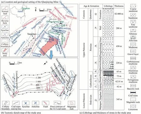
Fig.1.Geological overview of the Qianjiaying Mine (modified from Kailuan Group,2017).

Fig.2.Geotemperature and geothermal gradient vs.depth.
Between 300 and 900 m,the geothermal gradient fluctuates by approximate 2.12°C·hm-1and is hardly affected by depth(Fig.2b).However,deep mines typically present complex geological conditions.These conditions,combined with deep heat,can influence the geothermal gradient and result in geothermal anomalies,as verified in Qian 66,Qianshui 36,Qian 81,Qianbu 27,Qian 94,etc.At an~900 m depth,the geothermal gradient starts to increase;above this depth,geothermal anomalies are more common.
3.2.Vertical geothermal distribution
The geotemperature and geothermal gradient data include some anomalies in the vertical direction.The geotemperatures registered at depths of 500,700,and 900 m in several boreholes in the mine are compared in Fig.3.The geotemperature oscillates between 16.20 and 29.05 °C at 500 m depth,meaning that coal mine production does not involve a considerable heat hazard.At 700 m depth,the geotemperature in Qian 94 and Qian 66 occasionally reaches the first-degree heat hazard level(31–37°C).At 900 mdepth,the geotemperature reaches the first-degree heat hazard level in more boreholes; moreover,in some boreholes e.g.Qianbu 27 and Qian 66,it even reaches the second-degree heat hazard level(≥37°C),with a maximum of 40.2°C in Qian 94.The geotemperature variations in each borehole follow very similar trends at different depths.
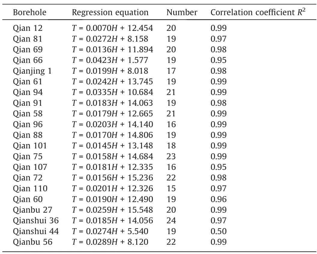
Table 1Linear regression equations between temperature and depth.
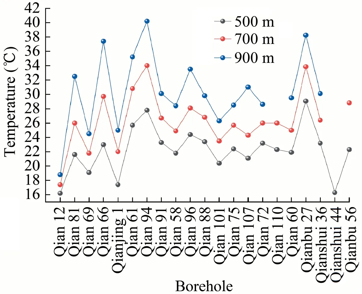
Fig.3.Geotemperatures registered at different depths and in different boreholes of the Qianjiaying Mine.
Among the 21 temperature measurement boreholes analyzed,two presented positive anomalies in the geothermal gradients(>3 °C·hm-1),i.e.Qian 66 (4.23 °C·hm-1) and Qian 94 (3.35 °-C·hm-1),which were both located in the southwestern part of the mine.Meanwhile,the geothermal gradients of Qian 12,Qian 69,Qian 101,Qian 75,and Qian 72 all presented negative anomalies (<1.6 °C·hm-1).
The geotemperature increased with the borehole depth,reaching maximum values of 50.4,50.2,42.4,and 40.8 °C in Qian 94(Fig.4a),Qian 66 (Fig.4b),Qianbu 27 (Fig.4c),and Qian 81(Fig.4d),respectively.In Qianbu 27,the geotemperature exceeded 31 °C at an~600-m depth (reaching the first-degree heat hazard level),while it exceeded 37 °C at an~830-m depth (reaching the second-degree heat hazard level).In Qian 94,the geotemperature reached the first-and second-degree heat hazard levels at~606-m and~785-m depths.In other boreholes e.g.Qian 66,Qian 61(Fig.4e),Qian 81,and Qianshui 36 (Fig.4f),the temperature reached the second-degree heat hazard level at greater depths.Notably,within depths of 1000 m,the geothermal gradient of Qian 94 (located in the southwestern part of the mine) remained relatively stable,and the geothermal curve exhibited a convexconcave shape.The geotemperature increased significantly at depths>1000 m,which reflected a gradual increase in the geothermal gradient.By linearly fitting the geotemperature data of Qian 94 for depths>1000 m,a high-temperature geothermal gradient was obtained (~7.25 °C·hm-1).Moreover,the geothermal gradient for depths > 1000 m was approximately twice that in the shallower interval.The geothermal curve for Qian 66 had a convex-concave shape within depths of 900 m,indicating a gradual increase in the geotemperature with depth.By linearly fitting the geotemperature data for depths>900 m,a high-temperature geothermal gradient was calculated (~10.55 °C·hm-1).Moreover,the geothermal gradient for depths > 900 m was~2.5 times that in the shallower interval.The geothermal gradient of Qianshui 36 (located in the middle of the mining area) for depths > 1000 m also increased significantly.
Overall,the boreholes showing geothermal anomalies in the vertical direction were mainly located in the central and southwestern parts of the mine; meanwhile,in the southwestern part of the mine,both the geotemperature and geothermal gradient were anomalous.
3.3.Horizontal temperature distribution
The results of the measurements conducted in the Qianjiaying Mine (see the contour map obtained at the depth of 850 m in Fig.5) depict considerable geothermal spatial variation.At an 850-m depth,the geotemperature was 20–34 °C,suggesting the influence of other factors in addition to depth.Some boreholes,e.g.Qianbu 27,Qianbu 21,Qianshui 36,Qian 61,Qianbu 35,Qianbu 36,Qian 81,Qianbu 35,Qian 66,and Qian 94,were assigned a firstdegree heat hazard level.Moreover,isotherms were distributed more sparsely in the eastern part of the mine than that in the western part.The distribution of geotemperature showed a generally decreasing trend from west to east.The geothermal anomalies were mainly distributed in the central and southwestern parts of the mine but were not obvious in the northeastern part.In summary,in the central and southwestern parts of the Qianjiaying Mine,there are spatial anomalies both in the vertical (in the geotemperature and geothermal gradient) and horizontal (in the geotemperature) directions.
4.Geological factors controlling the geothermal anomalies
4.1.Stratigraphic features
The geotemperature is influenced by several strata characteristics,including the caprock thickness,lithologies of the strata,spatial distribution pattern,and specific combination.Above the coalbearing strata of the Qianjiaying Mine,there exists a thick layer of loose Cenozoic sediments with thicknesses of~82–800 m.The thickness of this layer gradually increases from northeast to southwest.By comparing the distribution of this layer to that of the geothermal anomalies in the Qianjiaying Mine area,it is found that the sedimentary caprock is relatively thick.
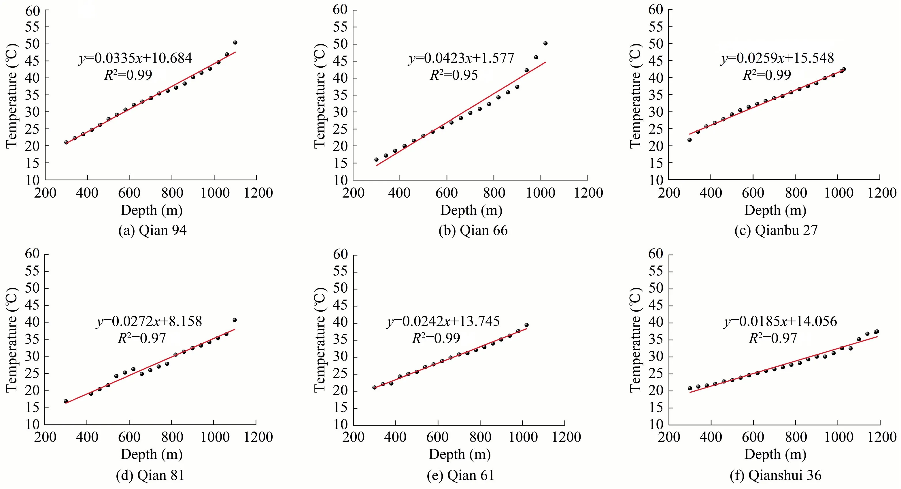
Fig.4.Geothermal curves reconstructed for different boreholes showing anomalies.
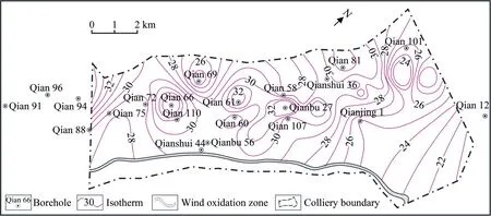
Fig.5.Geothermal contour map of the Qianjiaying Mine at the depth of 850 m (modified from Kailuan Group,2017).
The geothermal field is also influenced by lithology; different lithologies have different thermal conductivities.As a consequence,the local geotemperature tends to be positively correlated with the thermal conductivity of the rock [30].Generally,denser rocks have higher thermal conductivities than less dense rocks,implying faster heat transfer.The data collected in North China indicated that below the loose layer of the Qianjiaying Mine,the lithologic thermal conductivity should range between 0.40 and 2.87 W·m-1·K-1[31]; moreover,the average thermal conductivity should be~1.86 W·m-1·K-1,which is lower than that in Huaibei(2.49 W·m-1·K-1) and Huainan (2.59 W·m-1·K-1) coalfields [32].Notably,the thermal conductivity decreases from sandstone to mudstone and coal (i.e.with the increase in shale content).The coal-bearing strata of the Qianjiaying Mine are mainly composed of coal seams,clay rock,and sandstones.The thermal conductivities of the coal seams and clay rock are relatively low,effectively preventing deep heat loss.The basement of the coal-bearing strata consists of Ordovician limestones with a high thermal conductivity(i.e.allowing rapid warming).Due to the thermal insulation effect of rocks with low thermal conductivity (e.g.coal and mudstone),this kind of basement can easily accumulate heat in the case of favorable geological structures,leading to the formation of a local high-temperature area.In contrast,the loose Cenozoic deposits located above the bedrock of the Qianjiaying Mine are thick and have a low thermal conductivity [33].These characteristics lead to good heat preservation,which can produce a ‘‘pot-cover” effect and favor the occurrence of geotemperature anomalies.
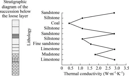
Fig.6.Thermal conductivities of the bedrock lithologies below the loose layer in the Qianjiaying Mine.
The formation combination present in the Qianjiaying Mine provides a good thermal insulation effect; the limestones and sandstones below the loose layer are combined with low thermal conductivity siltstones,mudstones,and coal seams (Fig.6),which function as thermal insulation barriers.Compared with other sedimentary layers,coal-bearing strata can block underground heat more efficiently [34].The thermal conductivity decreases from the basal Ordovician limestone to the shallowest strata.The Ordovician limestone,which presents a high thermal conductivity,favors the conduction of underground heat;meanwhile,the formation combination with poor thermal conductivity located above the basement effectively blocks heat loss and hence constitutes a good thermal insulation layer.The central and southwestern parts of the Qianjiaying Mine have characteristically thick loose layers and present geothermal anomalies,demonstrating that strata characteristics are among the factors affecting the occurrence of geothermal anomalies in the mine area.
4.2.Structural factors
In high-temperature geothermal fields,the fluids occurring in fissures and faults continuously transfer heat to shallower layers during the flow cycle [35].Typical structural factors influencing the geotemperature include folds and faults.
Since densely structured bedrock has a higher thermal conductivity than loose deposits and parallel horizontal layers have a higher thermal conductivity than vertical layers [34],the thermal conductivity of an older formation is generally higher than that of a younger formation.Therefore,the heat is more easily transferred along the layer direction than towards the upper layers.The thermal conductivities in the anticline and in the uplifted basement are relatively high; hence,heat can easily accumulate there.The basement of the coal-bearing strata in the Qianjiaying Mine is composed of Ordovician limestone,and above it,there are thicker coal-bearing strata and loose Cenozoic layers.This lithological framework leads to the accumulation of heat in the anticlines and in the uplifted basement (in the southwestern and central parts of the mine) and eventually to geotemperature or geothermal gradient anomalies.
Faults are favorable channels for the exchange and dissipation of heat from underground heat sources; in fact,high and low anomalies of heat flow are often observed near faults[33].The fold located in the northeastern part of the Qianjiaying Mine and the faults associated with the transition zone of the monocline are extremely developed(Fig.7)and are mainly represented by normal faults,suggesting the absence of geotemperature anomalies in this area.Meanwhile,the faults located in the central and southwestern parts of the mine are less developed,suggesting a low heat dissipation rate.All of these results are consistent with the observed distribution of the geotemperature anomalies.
According to the borehole data,Qian 66 (in the southwestern part of the mine) and Qianbu 27 (in the central part of the mine)consumed more flushing fluid during the drilling process [36].From this,it can be inferred that a deep fault zone corresponds to Qian 27 and Qian 66.Such a fault zone may connect the boreholes with deep heat sources,leading to geothermal anomalies.Hence,it is concluded that structural factors can considerably influence the occurrence of geothermal anomalies in the Qianjiaying Mine.
4.3.Groundwater activity
Due to the specific heat capacity of groundwater and its ease of flow,the deep geothermal field is also affected by the flow field of groundwater [37].The aquifer lithologies of the Qianjiaying Mine are the following (from old to new):the Middle Ordovician limestone (>300 m),the coal-bearing strata,and the Quaternary loose layer (Fig.8).There is almost no hydraulic connection between the coal-bearing strata and surface water in the Qianjiaying Mine,and the groundwater flows mainly between layers.The northeastern part of the Kaiping syncline corresponds to a groundwater recharge area,while the southwestern part is a groundwater discharge area.Due to coal mining,the former discharge area has become a recharge area.The groundwater in the coal-bearing strata is supplied by a karst aquifer in the Ordovician limestone basement and by a gravel aquifer at the bottom of the loose layer.At present,the average water inflow to the Qianjiaying Mine is 0.0116–0.2280 L·s-1·m-1,the normal water inflow is 531 m3·h-1,and the hydrogeological type is medium.The groundwater circulation involves continuous heat exchange.
Due to the geothermal gradient,geothermal flux and radiometric decay in the country rock,the groundwater is heated[7,39].The Ordovician limestone water and the deep hot water at the bottom of the Qianjiaying Mine can enter the coal-bearing strata along the fault,causing the temperature of the country rock to increase;moreover,the structures of magma intrusions can damage the aquifer,causing the formation of a water pipeline or storage space and resulting in geothermal anomalies in the central and southwestern parts of the mine.Due to the intrusion of magma in the central part of the mine,there should be hydraulic exchange between the coal-bearing strata aquifer (located in the center)and the Ordovician limestone aquifer (located at the bottom)[40].In addition,according to a previous study [36],the bedrock aquifer of the Qianjiaying Mine contains fissure water,and the deep heat flow can enter the upper layers through fissures or directly heat the groundwater,causing geothermal anomalies.Underground hydrothermal activity usually results in geothermal anomalies,while the presence of faults and fractures mainly determines the migration of geothermal water [41,42].Tectonism can cause the formation of fractures,which in turn can function as channels of geothermal fluids; aquifers on both sides of a fault are prone to geothermal anomalies [43].The deep faults and fissures in the central and southwestern parts of the Qianjiaying Mine function as efficient channels for the upwelling of deep hot water(or Ordovician limestone water),which constitutes the underground heat source.The heat exchange between the underground hot water and the country rock results in geothermal anomalies.
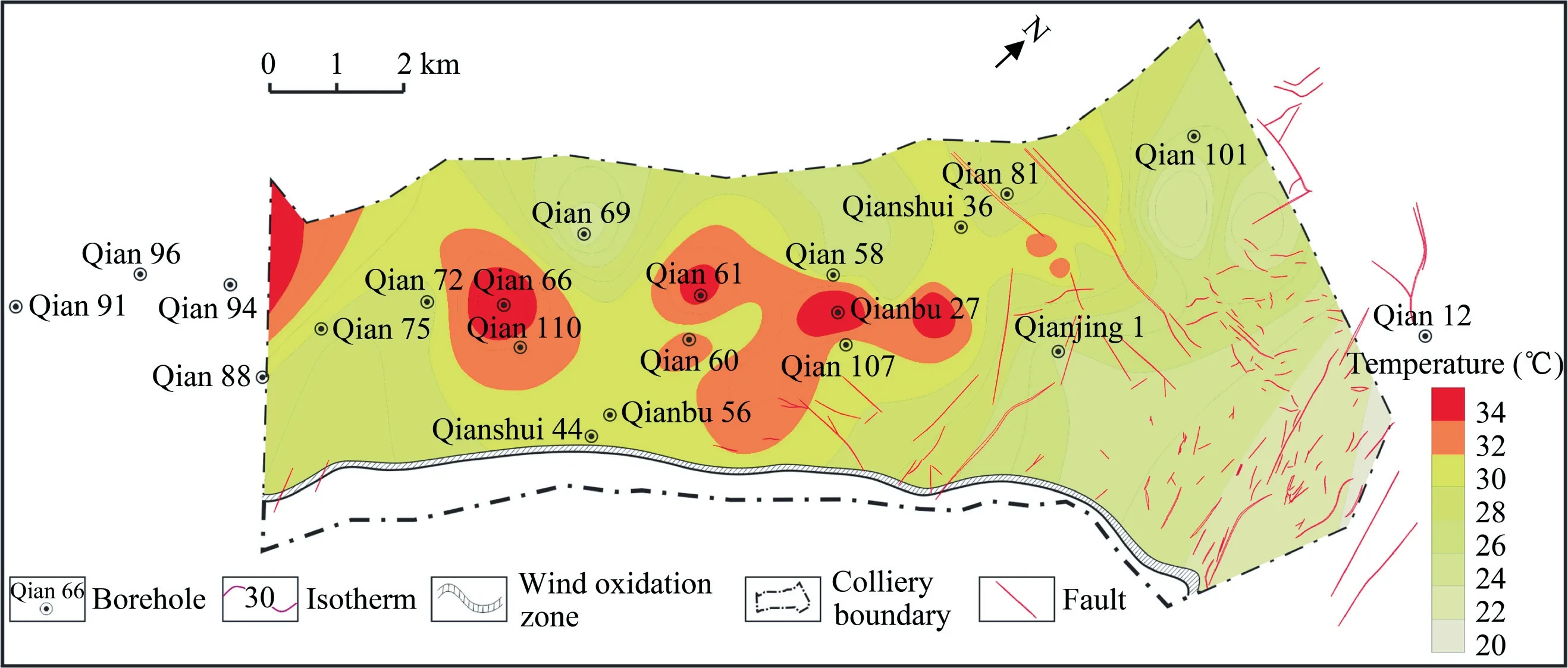
Fig.7.Geotemperature and fault distribution.
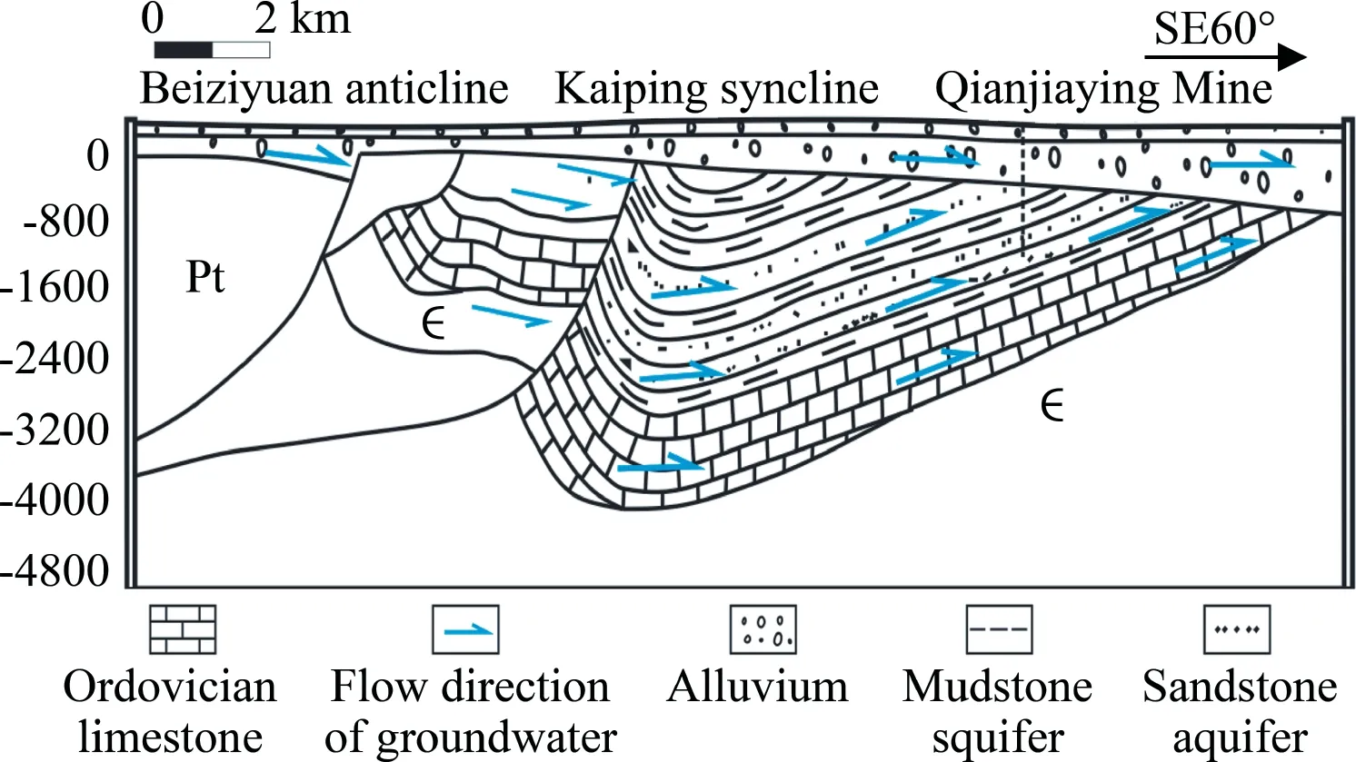
Fig.8.Schematic diagram of the groundwater flow in the Kailuan mining area(after [38]).
4.4.Magma intrusion
When studying the influence of magma intrusions on the geothermal field,two main aspects are usually considered:(1)the geological age of the magma intrusion and(2)the size and distribution of the magmatic rock and the thermal conductivity of the country rock [44].According to the borehole exploration data,a total of 13 boreholes in the Qianjiaying Mine cut magmatic rock(mostly late Yanshanian intrusive rock) [45].
The influence of magma intrusions on the geothermal field of the country rock in the Qianjiaying Mine during different periods was simulated using the finite element software ANSYS Workbench,establishing a cylindrical model of the magma intrusion.Since this model was axisymmetric,1/8 of the cylinder was analyzed (Fig.9).The radii of the magma intrusion and country rock model were 15 and 5000 m,respectively.Meanwhile,the stratigraphic model was established according to the stratigraphic column in Fig.6.The lithologies of the model were bedrock located below a loose layer,for a total thickness > 1000 m.The average thermal conductivity of the magma intrusion was 2.43 W·m-1·K-1[46],while the average thermal conductivities of different lithologies are shown in Table 2.Moreover,the specific heat capacity and density considered for the geological model are shown in Table 3.
The boundary conditions of the model were as follows:the initial temperature of the magma intrusion was 1000 °C,the upper boundary temperature of the model was 10 °C,and the lower boundary temperature of the country rock was 50°C;additionally,the lower boundary of the country rock represented a constant heat flow boundary.According to Wang & Huang [47],the terrestrial heat flow near the Qianjiaying Mine is equal to 48.6 mW·m-2.Therefore,the geothermal fields after 10,1000,5000,and 10000 a since the magma intrusion were simulated (see Fig.9).

Table 2Thermal conductivities of different lithologies in North China [31].

Table 3Densities and specific heats of different lithologies considered for the geological model [46].
The temporal evolution of the geothermal field suggests the following evolution.After the magma intrusion and the transfer of heat to the country rock,the temperature of the intrusion gradually decreased,and the temperature of the country rock near the intrusion rapidly increased,leading to the formation of a transverse temperature change zone in the country rock.The closer the center of the intrusion was,the higher the temperature of the country rock.After 10 a since the magma intrusion (Fig.9a),the magma temperature decreased from the initial 1000 to 866.12°C;after 1000 a(Fig.9b),the magma’s thermal disturbance expanded,and the maximum magma temperature was 239.61 °C;after 5000 a,(Fig.9c),the magma’s thermal disturbance further expanded,and the maximum magma temperature was 66.55 °C;finally,after 10000 a (Fig.9d),the geothermal field between the magma intrusion and the country rock reached thermal equilibrium,leading to the formation of a stable geothermal field.Overall,the temporal evolution of the magma intrusion temperature(Fig.10) demonstrates that the cooling process was nonlinear and that its velocity was proportional to the intrusion radius[48].After the occurrence of the magma intrusion event,the magma temperature decreased gradually; moreover,the intrusion and the country rock approached thermal equilibrium only after~8000 a.

Fig.9.Distribution of the geothermal field at different moments after the magma intrusion event.

Fig.10.Temporal evolution of the magma heat.
The age of the magma intrusion in the Qianjiaying Mine is>60 Ma.A previous study [49] has shown that when the emplacement depth of magmatic activity is less than 10 km and the intrusive age is >0.5 Ma,its heat has no direct contribution to the geothermal field.In particular,the heat released from the magma intruded in into the Dingji Mine was simulated,and it was no longer transferred to the country rock after 100000 a[50].In other words,a magma intrusion seems to have a great influence on the geothermal field of the country rock initially;however,the magma loses its heat during a long period of cooling and reaches thermal equilibrium with the country rock.Therefore,the intrusion of magma will inevitably lead to formation fractures,which will serve as channels for deep heat,allowing the upward circulation of water and leading to the formation of local geothermal anomalies.The deep fractures in the area of the Qianjiaying Mine characterized by geothermal anomalies likely originated from a magma intrusion[36].Therefore,it can be inferred that the channels necessary for the upward migration of geothermal water were a consequence of the magma intrusion,while the heat released by the magma had little effect on the present-day geothermal field.
4.5.Discussion
The terrestrial heat flow,as well as the density,specific heat,and thermal conductivity of rocks,are important parameters to consider when studying the geotemperature of a site.The terrestrial heat flow results from the Earth’s thermal evolution and directly reflects the distribution characteristics of the geothermal field.The terrestrial heat flow obtained for the Qianjiaying Mine(48.6 mW·m-2) [47] is lower than the average heat flow obtained for the Chinese mainland((61.5±13.9)mW·m-2)[47,51].Another study[43]demonstrated that other factors(e.g.the terrestrial heat flow,the oxidation and heat release of sulfides in the coal-bearing strata,and the attenuation of radioactive elements in the coalbearing strata) usually have negligible influences on the presentday geothermal field of the Qianjiaying Mine.
Notably,the model used in this study to simulate the influence of magma heat on the present-day geothermal field is relatively simple and only considers transient heat conduction after the magma intrusion event.Hence,it cannot accurately reflect reality but can still be used effectively to study the temporal evolution of geotemperature under various conditions (e.g.heat transfer modes,thermal-fluid–solid coupling,phase transitions and geological conditions).In the real world,magmatic rocks have variable distribution patterns and are affected by complex geological factors when they intrude into strata.Therefore,in future work,there is a need to fully combine more accurate drilling and measurement data (e.g.the thermal conductivity of rocks,the terrestrial heat flow and deep underground geological conditions),consider more relevant processes,and establish a more realistic model.
5.Conclusions
(1) The correlation between geotemperature and depth in the Qianjiaying Mine is good.Except for borehole Qianshui 44,these two parameters showed correlation coefficients≥0.95.In each borehole,the geothermal gradient was hardly related to depth.Overall,the geothermal gradient in the Qianjiaying Mine varied between 0.70 and 4.23 °C·hm-1,while the average geothermal gradient was~2.12 °C·hm-1.
(2) Geothermal anomalies were found to occur in the central and southwestern parts of the Qianjiaying Mine,reaching the first-degree heat hazard level at~600-m depth and the second-degree heat hazard level at~800-m depth.The geotemperature and geothermal gradients were anomalous in the southwestern part of the mine; moreover,the geothermal gradient gradually increased in the deep mine.
(3) The strata characteristics,geological structures,and groundwater activity were identified as the main factors causing geothermal anomalies in the study area.Several control factors are related and interact with each other.The heat source of the mine is represented by the deep heat flow (or the Ordovician limestone water),which is transmitted to the upper layers through fractures or deep faults related to the intrusive rock.The anticlines and uplifted basement regions are favorable structures for heat accumulation.The thick loose layer provides good heat insulation and preservation.By~8000 a after the magma intrusion event,the magma reached thermal equilibrium with the geothermal field of the country rock; the intrusion has little influence on the present-day geothermal field.It is concluded that the geothermal anomalies observed in the Qianjiaying Mine result from the interaction of stratigraphic characteristics,geological structures,and groundwater flow.
Acknowledgements
The authors gratefully acknowledge the financial support of the National Natural Science Foundation of China (Grants Nos.41702167 and 41972169)and A Project funded by the Priority Academic Program Development of Jiangsu Higher Education Institutions.
杂志排行
矿业科学技术学报的其它文章
- Identification of digital technologies and digitalisation trends in the mining industry
- Experimental and theoretical investigation on mechanisms performance of the rock-coal-bolt (RCB) composite system
- Creep characteristics of coal and rock investigated by nanoindentation
- An experimental investigation of the fracturing behaviour of rock-like materials containing two V-shaped parallelogram flaws
- Comparative evaluation of different statistical tools for the prediction of uniaxial compressive strength of rocks
- A rapid and accurate direct measurement method of underground coal seam gas content based on dynamic diffusion theory
