保护性耕作农田和柠条带状配置草地防风蚀效果的风洞测试
2017-07-12孙悦超麻硕士
孙悦超,麻硕士,陈 智
(1. 岭南师范学院机电工程学院,湛江 524048;2. 内蒙古农业大学机电工程学院,呼和浩特 010018)
保护性耕作农田和柠条带状配置草地防风蚀效果的风洞测试
孙悦超1,麻硕士2,陈 智2
(1. 岭南师范学院机电工程学院,湛江 524048;2. 内蒙古农业大学机电工程学院,呼和浩特 010018)
为比较分析保护性耕作农田与柠条带状配置修复退化草地的防风蚀机理和防风蚀效果,利用移动式风蚀风洞及相关配套设备对内蒙古乌兰察布寒旱区的保护性耕作农田、传统旱作农田和退化草地、柠条带状配置草地进行风蚀风洞原位测试,研究其风速廓线、输沙通量等风沙运动规律,分析保护性耕作农田、柠条带状配置草地的防风蚀情况。结果表明:保护性耕作农田、柠条带状配置修复草地的输沙通量随地表高度的变化呈“C”字形分布,有别于传统耕作农田和退化草地的输沙通量随地表高度的增加按指数规律迅速衰减;保护性耕作农田、柠条带状配置草地的防风蚀机理,主要在于保护性耕作农田的直立残茬和柠条带状配置可对近地表风速产生阻挡、分解、疏散作用,从而使近地表风速造成不同程度削弱;当风洞中心风速为11 m/s 时,在距地表50 mm处保护性耕作农田相比传统耕作农田的风速降低率达86.44%,柠条带状配置草地相比退化草地的风速降低率为70.69%,近地表风速的降低是保护性耕作农田和柠条带状配置草地有效防治土壤风蚀的根本原因;保护性耕作农田和柠条带状配置草地的风沙流主要活动在距地表40 cm高度以下,占总输沙量的90%左右,而对照传统耕作农田和退化草地的风沙流则主要活动在距地表20 cm以下,占总输沙量的85%以上。
风;侵蚀;风洞;土地退化;风蚀;保护性耕作;灌草带状;输沙通量
0 引 言
传统耕作农田和草地退化发生的土壤风蚀破坏地表原有结构,是造成中国北方寒旱区土地退化、甚至沙漠化的主要原因之一。北方寒旱区土地沙化一旦发生则很难逆转,而且会给当地社会经济和生态环境带来严重危害,甚至影响到周边地区。环保部对北方一些城市的颗粒物源解析表明,扬尘是城市颗粒物的主要来源之一,北京PM2.5本地排放源中扬尘占到了总来源的14.3%[1];干燥多风的内蒙古呼和浩特、包头等城市的PM2.5扬尘所占比例会更高。采取科学有效方法来防治草地、农田土壤风蚀既可防止土地退化、沙化,同时也是控制大气颗粒物污染的重要有效途径之一。为行之有效防治旱作农田、退化草地土壤风蚀,中国农业大学、内蒙古农业大学等单位近十几年来致力于保护性耕作农田、灌草带状配置修复退化草地防风蚀研究,并取得了一些成果[2-7]。
保护性耕作农田防治土壤风蚀,是因为它将作物秸秆覆盖于农田地表并留高茬,直立高茬可分解风力对地表的剪应力,消耗风动量;另外残茬根系有固土并减少地表土壤水分蒸发作用,还可拦截风沙流中的土壤颗粒,降低沙尘颗粒对地表的磨蚀作用;再有,被割掉的秸秆覆盖于地表,可使地表免受风的直接吹蚀,保护了易蚀性土壤颗粒[8-10]。灌草带状配置则是在退化严重的低覆盖、甚至沙漠化的草地上,通过移栽耐寒冷、干旱的柠条等灌木对地表植被重新进行科学配置,使近地表气流场发生变化、并降低地表风速,从而实现抑制或削弱风沙活动的强度,进而阻止风沙流的形成并可固定流沙[11-14]。
农牧业用地是中国北方寒旱区风蚀沙害的主要土地。农牧业用地的土壤可蚀性除了受土壤性质的影响外,其实更重要的是受地表植被的影响。Wolfe等[15]研究认为植被覆盖能提高地表空气动力学粗糙度、降低风速并阻挡沙尘,对风蚀地表起到保护作用。陈智等[16]研究了保护性耕作地表的风沙流特性,赵永来等[17]针对不同植被盖度和残茬高度的保护性耕作农田近地表风速阻挡效果进行了分析研究,邢恩德等[18]研究了植被盖度对典型草原区地表风沙流结构及风蚀量影响,龚玺等[19]则对内蒙古草原近地层垂直风速廓线进行了观测研究,孙悦超等[20]研究了保护性耕作农田和无退化草地的抗风蚀效率,宣传忠等[2]对内蒙古四子王旗草地不同修复模式进行了抗风蚀试验研究。以上研究虽然证实了保护性耕作方式和提高草原地表植被覆盖度可有效减少农牧业用地的风蚀沙害,柠条灌草带状配置是适合内蒙古阴山北麓寒旱区且有很好防风蚀效果的退化草地修复模式[21-23]。但把保护性耕作农田、柠条灌草带状配置草地这2种防风蚀方法进行比较研究还未见报道,因此本文通过野外风洞原位测试对二者的近地表风沙运动参数进行定量研究,比较它们的近地表风速廓线、输沙通量、风沙流结构,进而深入探索它们的防风蚀机理,为防治旱作农田、草地土壤风蚀提供科学依据。
1 研究区概况
试验地表位于内蒙古自治区中部,阴山以北的乌兰察布高原。海拔1 500~1 700 m,年降水量为250~400 mm,多集中在夏季。该区为中温带大陆性季风气候,7~8月降水量占全年的70%左右,年蒸发量高达1 848.3 mm,约为降水量的5倍。4~5月连续无降水日数一般在30~50 d以上,大于17 m/s的大风日数在30 d左右,风大、干旱、沙多是该地冬春季的主要特征,是典型的以农田、草地风蚀沙化为特征的生态脆弱区[24-25]。
当地农作物以抗寒耐旱性较强的莜麦为主,并以传统耕作方式为主,近年来保护性耕作方式获得了一定推广。草地则是以冷蒿、无芒隐子草、短花针茅为主,植被稀疏低矮,一般为8 cm高,盖度为13%~20%。内蒙古农业大学以陈智教授为首的防风蚀研究团队在此建立了灌草带状配置修复退化草地试验基地。该基地包括退化草地试验区、带状柠条配置修复试验区和冰草修复试验区,每个试验区的面积为500 m2左右。这里春季干旱多风,土壤坚硬、透水通气能力差,主要为淡栗钙土。土壤厚度约为1 m,在40~50 cm深度出现钙积层,有机质含量1%~2.5%,粒径在1~0.25 mm的成分约占18%,粒径在0.25~0.05 mm的成分约占40%。土壤的结构性差,砂粒含量高,难以形成团粒结构,土壤抗风蚀能力差。
2 设备与方法
2.1 测试设备
主要试验设备为内蒙古农业大学研制的0FDY-1.2型直流吹气式可移动风蚀风洞。它由过渡段、整流段、收缩段和试验段组成,风洞结构和设备布置如图1。风洞全长为11.8 m,试验段为长7.2 m、宽1.0 m、高1.2 m的矩形无底截面;收缩段长1.2 m,收缩比为1.7;稳定段长0.41 m、宽1.16 m,高1.76 m,内置不锈钢正六边形蜂窝器和一层1 mm不锈钢纱网;配套风机直径1.4 m、型号为BK-57型的轴流风机,并由型号为40G型的40 kW发电机组驱动。在试验段可模拟与自然风梯度变化相似的风速廓线,风速在0~20 m/s连续可调。经性能测试,风洞风速的横向不均匀度、气流稳定性偏差、湍流度、轴向静压梯度等各项空气动力学指标均符合测试要求。人工大气边界层调节装置能将边界层厚度从10 cm增厚至96 cm左右,并可将风速廓线调节至所需形状,实现了气流边界层的增厚和风速廓线的调节功能。测试时在风洞的试验段放置风速廓线仪和旋风分离式集沙仪,可获取风洞风速和风蚀量等数据。
风速由风速廓线仪采集后通过数据采集卡传给数据采集处理系统,并在计算机中显示、记录、保存[26-27]。风速廓线仪及风速采集系统如图2,由机架、6个热膜风速传感器和变送器、Zigbee 无线网络数据发送终端、电池组成。试验时,风速廓线仪置于距风洞出口1.8 m、距洞壁0.3 m处,测距地表0~70 cm间6个不同高度的风速并由软件生成风速廓线。

图1 移动式风蚀风洞结构及设备布置Fig.1 Structure and equipment arrangement of movable wind erosion tunnel
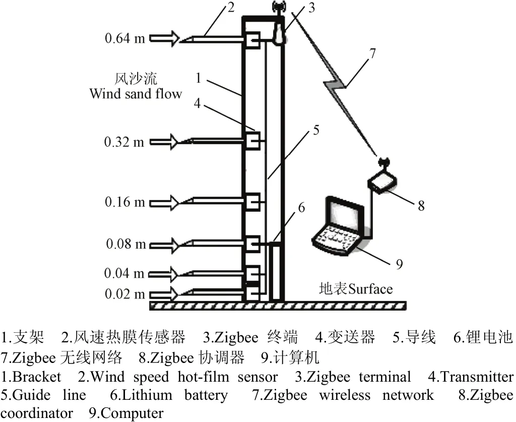
图2 无线风速廓线仪及风速采集系统Fig.2 Wireless wind speed profiler and wind speed collection system
集沙仪由防护罩、支撑底座、气流管、旋风分离器和集沙盒等组成[28-30],如图3。试验前将集沙仪置于风洞轴线距出口1.2 m处,8个集沙单元分别收集距地表3~70 cm高度间对应8个高度的输沙量,集沙单元通过矩形气流管口采集风蚀物,气流管口高3 cm、宽1.5 cm;每一风速试验结束后由精度为千分之一的电子天平通过称取对应集沙盒质量来计算相应输沙量,然后根据气流管口截面积、测试时间和输沙量计算不同地表在不同风洞中心风速下的各高度输沙通量。
2.2 测试方法
鉴于试验区气候,选择在植被未返青、风蚀最严重的4月进行测试。被测保护性耕作农田地表见图4a,种植作物为莜麦,留茬高平均30 cm,平均行距19.8 cm,植株平均直径5 mm,平均密度402株/m2,植被盖度为70%,地表5 cm深度土层平均含水率为6.46%。对照传统耕作农田测试前耙平处理,地表5 cm深度土层平均含水率为2.52%,见图4b。测试期间环境平均温度8.5 ℃,大气平均压力825 kPa。
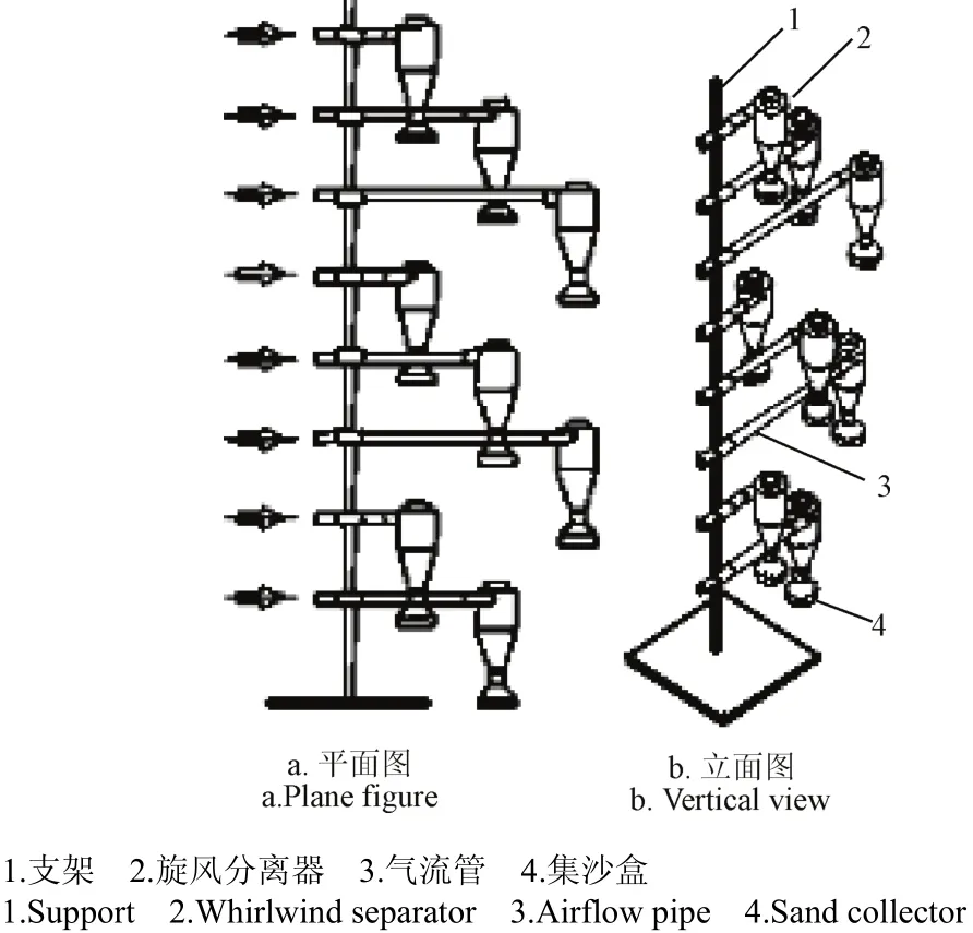
图3 旋风分离式集沙仪Fig.3 Whirl type separation sand sampler
带状柠条配置修复草地见图4c,其植被覆盖度为40%,柠条带平均高30 cm,平均行间距120 cm,地表深度5 cm土层平均含水率为5.27%。对照退化草地见图4d,地表覆盖度为20%,以冷蒿、无芒隐子草等枯草为主,地表深度5 cm土层平均含水率为2.41%。测试期间环境平均温度为6.5 ℃、大气平均压力823 kPa。鉴于试验风速与研究区自然风速的一致性,并且研究区传统耕作农田和退化草地的起沙风速均约为6 m/s,故试验设计6~18 m/s间的5种风洞中心风速分别对试验地表进行连续吹蚀1 h,每一地表分别进行3次重复试验,取输沙量结果平均值进行计算分析。

图4 测试地表Fig.4 Test surface
3 结果与分析
3.1 风速廓线
风速廓线是指风速随高度的分布曲线,是衡量近地表的风速分布规律和土壤风蚀发生情况的重要指标之一。当下垫面覆盖植被时,由于植被对空气流速的阻挡和削弱,使近地表风速减小,并且破坏了无植被时近地表风速随高度变化的对数规律。
鉴于4种地表在不同风洞中心风速下的风速廓线极为相似,因此选择风洞中心风速为11 m/s时它们的风速廓线进行对比分析,见图5。由图5可知,在相同的风洞中心风速下,距地表30cm的植被高度以下的保护性耕作农田和柠条带状配置草地的风速明显低于它们各自对照的传统耕作农田和退化草地。在相同的风洞中心风速11 m/s时,在距地表50 mm处保护性耕作农田相比传统耕作农田风速减小率达86.44%,柠条带状配置草地相比退化草地风速减小率为70.69%,可见,保护性耕作农田和柠条带状配置草地对近地表气流的消弱与阻挡效果非常明显。因此,近地表风速的降低使风速廓线的改变是保护性耕作农田和柠条带状配置草地能够有效防治土壤风蚀的根本原因。
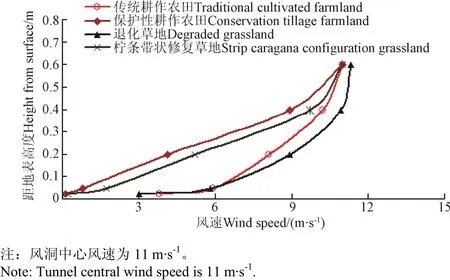
图5 不同地表类型的风速廓线Fig.5 Wind speed profile of different land surface types
由图5还可以看出,在相同的风洞中心风速下,在距地表相同高度时柠条带状配置草地的风速要高于对应保护性耕作农田,这也是导致柠条带状配置草地的最大输沙通量出现在距地表30 cm附近出现(图6),高于保护性耕作农田的最大输沙通量出现在距地表25 cm附近的主要原因。
3.2 输沙通量垂向分布规律
风沙流是风及其所携带的沙物质形成的气-固两相流,是风沙物理学的核心内容,也是防沙治沙工程的基础理论之一。风沙流中输沙通量的垂向分布则是沙粒微观运动的宏观表现,对正确估计输沙率、分析土壤风蚀具有重要意义。
通过对4种地表的测试数据进行处理,做出它们在不同风速下的输沙通量随距地表高度的变化曲线,见图6。结果表明,退化草地和传统耕作农田的输沙通量均按指数函数规律随高度的增加迅速衰减,见图6a、图6c,与沙漠、戈壁地表的风沙流结构较为相似。而保护性耕作农田和柠条带状配置修复草地的输沙通量随距地表高度的变化呈多项式变化,它们的输沙通量曲线随距地表高度变化呈“C”字形分布,完全不同于对照传统耕作农田和退化草地的输沙通量随距地表高度变化呈指数函数迅速衰减的规律,见图6b、图6d。
4种地表的输沙通量曲线出现这种情况,是因为保护性耕作农田直立残茬和柠条带状配置草地的直立柠条带的存在,使它们的近地表气流场发生改变。气流的一部分受直立残茬层和柠条带的阻挡被迫抬升,使残茬层和柠条带高度以下通过的气流大大减少,风速迅速降低;同时由于保护性耕作农田残茬层和柠条带状草地的柠条带存在,使得气流的活动层被抬高,相应的最大输沙通量也被提升一个高度。因此最大输沙通量出现在了接近直立残茬顶或柠条带顶部的位置,即输沙通量曲线出现了“鼻尖”,从而输沙通量曲线随距地表高度变化呈“C”字形分布。

图6 测试地表的输沙通量垂向分布规律Fig.6. Flux density profile of aeolian sediment drift of test surface
由图6b可见,保护性耕作农田在试验各级风速下输沙通量随高度变化均有2个极值点出现,第一个极值点在距地表6 cm附近,对应输沙通量较小;第二个极值点则出现在距地表25 cm附近,是最大输沙通量。而图6d的柠条带状配置草地输沙通量在距地表30 cm附近时各种风速下都有极大值点出现,对应值为最大输沙通量,但没有保护性耕作农田较小的第一个输沙通量极值点出现。两种地表的输沙通量垂向曲线虽然存在有无较小极值点的区别,但并不影响输沙通量曲线在垂向呈“C”字形的分布规律。
随风速的增大4种试验地表的输沙通量均有不同程度增加,在高风速时增幅愈加明显。保护性耕作农田在近地表6 cm附近时出现较小的输沙通量极值点,是因为保护性耕作农田地表存有大量植被落叶和少量倒伏残茬,地表平均覆盖度达70%。地表2~3 cm的高度恰好处于植被落叶覆盖层之下,受覆盖层的保护作用,输沙通量几乎为零。而距地表6 cm以上高度则处于植被落叶覆盖层之上,风沙流中的沙尘颗粒在落叶覆盖层以上输送,同时受到植被落叶覆盖层和直立残茬的强烈阻挡,覆盖层内风速很低,因此出现了输沙通量较小的极值点。柠条带状配置修复退化草地没有这个极值点是因为对应地表植被盖度仅为40%,不存在明显的地表2~3 cm落叶覆盖层,因此第一个较小的极值点没有出现。
经过以上分析可见,保护性耕作农田、柠条带状配置草地的防风蚀机理,主要在于保护性耕作农田直立残茬和带状柠条对近地表风速的阻挡、分解、疏散作用,从而使近地表风速发生大幅削弱。
3.3 输沙量百分比分析
对输沙通量随高度变化的数据进行曲线拟合,通过对输沙通量在不同高度层分段积分计算出了保护性耕作农田和柠条带状配置草地在不同高度层的输沙量百分比,见图7。
由图7a可见,在试验各级风速下保护性耕作农田最大输沙量百分比出现在距地表20~30 cm高度范围内,占相应风速下输沙总量的28.64%~30.84%,且输沙量百分比随风速的变化幅度较小。由图7b可知,柠条带状修复草地的输沙量最大百分比在试验各级风速下都出现在距地表20~40 cm高度范围内,占相应风速下输沙总量的55%~60%。
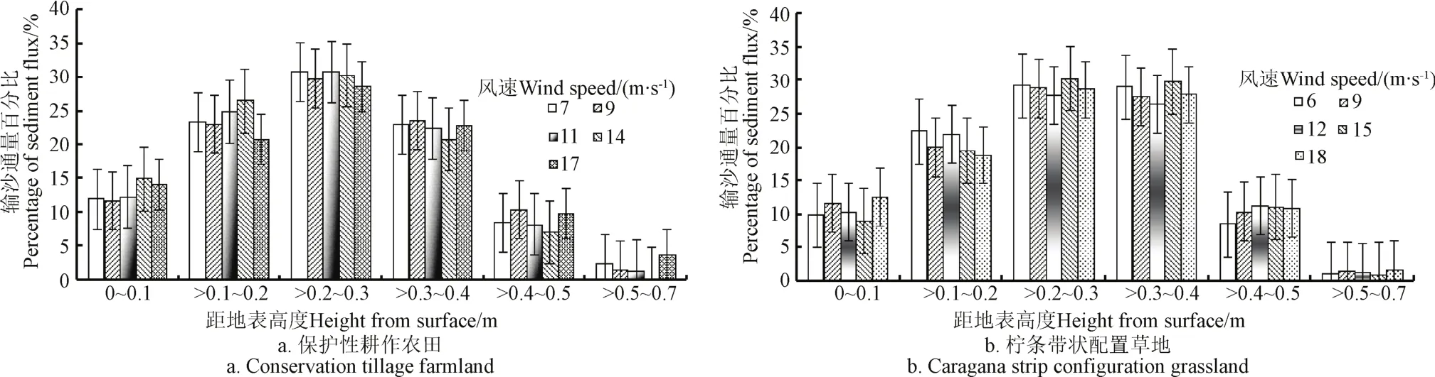
图7 保护性耕作农田及柠条带状配置草地的输沙通量百分比Fig.7 Percentage of sediment flux about conservation tillage farmland and caragana strip configuration grassland
由图7还可以看出,保护性耕作农田和柠条带状配置草地的风沙流主要活动在距地表40 cm高度以下范围内,占到总输沙量的90%左右(保护性耕作农田14 m/s时最大为92.74%,9 m/s时最小为88.13%),距地表50 cm高度范围内输沙量百分比达到95%以上。距地表50 cm高度以上的输沙量几乎接近于零,说明风沙流主要集中在近地表50 cm的高度范围内向前运动。对照的传统耕作农田和退化草地的输沙量则以近地表约20 cm高度为界,20 cm高度以上各层的输沙量百分比较小。传统耕作农田在20 cm以上高度层的输沙量总和占总输沙量的比例不足10%,退化草地在20 cm以上高度层的输沙量总和占总输沙量的比例不足15%,即这2种地表85%以上的风沙流在近地表20 cm以下运动。
4 结 论
利用移动式风蚀风洞及相关设备对保护性耕作农田、传统旱作农田、退化草地、柠条带状配置草地4种地表进行了野外风洞原位测试,通过对不同测试情况下的集沙仪采集量和风速廓线仪风速数据进行分析处理从而获取了4种被测地表的近地表风沙流运动规律。着重根据输沙通量垂向分布图,从地表植被对土壤的保护、植被对风蚀物颗粒的阻挡和近地表风速廓线等方面较为详细地分析了保护性耕作农田、柠条带状配置修复退化草地的防风蚀机理,获得的主要结论如下:
1)保护性耕作农田、柠条带状配置草地的近地表风沙运动较为相似:在试验各级风速下,它们的输沙通量曲线随地表高度的增加呈“C”字形分布,完全不同于传统耕作农田和退化草地的输沙通量曲线随地表高度的增加呈指数规律衰减。
2)风洞中心风速为11 m/s时,在距地表50 mm处保护性耕作农田相比传统耕作农田风速降低率达86.44%,柠条带状配置草地相比退化草地风速降低率为70.69%,近地表风速的降低是保护性耕作农田和柠条带状配置草地能够有效防治土壤风蚀的根本原因。
3)保护性耕作农田和柠条带状配置草地的风沙流主要活动在距地表40 cm高度以下,占总输沙量的90%左右,距地表50 cm高度范围内输沙量百分比达到95%以上;而对照传统耕作农田和退化草地的风沙流则主要活动在距地表20 cm以下,占总输沙量的85%以上。
[1] 李洋阳,刘思宇,单春艳,等.保护性耕作综合效益评价体系构建及实例分析[J]. 农业工程学报,2015,31(15):48-54. Li Yangyang, Liu Siyu, Shan Chunyan, et al. Framework for comprehensive benefit assessment on conservation tillage and its application[J]. Transactions of the Chinese Society of Agricultural Engineering (Transactions of the CSAE), 2015, 31(15): 48-54. (in Chinese with English abstract)
[2] 宣传忠,陈智,刘海洋,等. 内蒙古四子王旗草地修复试验基地不同修复模式的抗风蚀试验[J]. 农业机械学报,2016,47(8):164-170. Xuan Chuanzhong, Chen Zhi, Liu Haiyang, et al. Tests on anti-wind erosion in different restoration modes of desertification grassland at experimental base in Siziwang Banner, Inner Mongolia[J]. Transactions of the Chinese Society of Agricultural Machinery, 2016, 47(8): 164-170. (in Chinese with English abstract)
[3] 冯晓静,高焕文,王丽洁,等. 北京周边典型农田风蚀风洞试验与防治分析[J]. 农业机械学报,2008,39(7):64-67. Feng Xiaojing, Gao Huanwen, Wang Lijie, et al. Wind erosion experiment and countermeasures on typical farmlands around Beijing[J]. Transactions of the Chinese Society for Agricultural Machinery, 2008, 39(7): 64-67. (in Chinese with English abstract)
[4] 孙悦超,陈智,赵永来,等. 阴山北麓农牧交错区草地土壤风蚀测试[J]. 农业机械学报,2013,44(6):143-147. Sun Yuechao, Chen Zhi, Zhao Yonglai, et al. Test of grassland soil erosion of farming-pastoral zone in northern foot of Yinshan mountains[J]. Transactions of the Chinese Society for Agricultural Machinery, 2013, 44(6): 143-147. (in Chinese with English abstract)
[5] 孙悦超. 内蒙古后山地区不同地表覆盖条件下土壤抗风蚀效应测试研究[D]. 呼和浩特:内蒙古农业大学,2008. Sun Yuechao. Test Research on Soil Resistance to Wind Erosion Effect in the Different Surface Coverage in Houshan Area of Inner Mongolia[D]. Huhhot: Inner Mongolia Agricultural University, 2008. (in Chinese with English abstract)
[6] 孙悦超,麻硕士,陈智,等. 保护性耕作农田风沙流空间分布规律研究[J]. 干旱地区农业研究,2009,27(4):180-184. Sun Yuechao, Ma Shuoshi, Chen Zhi, et al. Testing and research on space distribution rule of drifting sand flux on farmland with conservative tillage[J]. Agricultural Research in the Arid Areas, 2009, 27(4): 180-184. (in Chinese with English abstract)
[7] 陈智. 阴山北麓农牧交错区地表土壤抗风蚀能力测试研究[D]. 呼和浩特:内蒙古农业大学,2006. Cheng Zhi. Testing Study on Resistance to Wind Erosion of Land Surface Soil in the Cross Region Between Farmland and Grassland in Yinshan Mountain Area[D]. Huhhot:Inner Mongolia Agricultural University, 2006. (in Chinese with English abstract)
[8] 孙悦超,麻硕士,陈智,等. 植被盖度和残茬高度对保护性耕作农田防风蚀效果的影响[J]. 农业工程学报,2010,26(8):156-159. Sun Yuechao, Ma Shuoshi, Chen Zhi, et al. Effect elements research on anti-wind erosion of conservation tillage farmland[J]. Transactions of the Chinese Society of Agricultural Engineering (Transactions of the CSAE), 2010, 26(8): 156-159. (in Chinese with English abstract)
[9] Wang X, Wang T, Dong Z, et al. Nebkha development and its significance to wind erosion and land degradation in semi-arid northern China[J]. Journal of Arid Environments, 2006, 65: 129-141.
[10] Zhang Chunlai, Zou Xueyong, Gong Jirui,et al. Aerodynamic roughness of cultivated soil and its influences on soil erosion by wind in a wind tunnel[J]. Soil & Tillage Research, 2004, 75: 53-59.
[11] 姜丽娜,杨文斌,卢琦,等. 低覆盖度行带式固沙林对土壤及植被的修复效应[J]. 生态学报,2013,33(10):3192-3204. Jiang Lina, Yang Wenbin, Lu Qi, et al.The effect of low-covered sand-fixing forest belts on restoration of the soil and vegetation[J]. Acta Ecologica Sinica, 2013, 33(10): 3192-3204. (in Chinese with English abstract)
[12] 高函,吴斌,张宇清,等. 行带式配置柠条林防风效益风洞试验研究[J]. 水土保持学报,2010,24(4):44-47. Gao Han, Wu Bin, Zhang Yuqing, et al. Wind tunnel test of wind speed reduction of caragana korshinskii coppice[J]. Journal of Soil and Water Conservation, 2010, 24(4): 44-47. (in Chinese with English abstract)
[13] Funk R, Engel W. Investigations with a field wind tunnel to estimate the wind erosion risk of row crops[J]. Soil & Tillage Research, 2015, 145(145): 224-232.
[14] Gong Guoli, Liu Jiyuan, Shao Quanqin, et al. Sand-fixing function under the change of vegetation coverage in a wind erosion area in northern China[J]. Journal of Resources and Ecology, 2014, 5(2): 105-114.
[15] Wolf S A, Nickling W G. Shear stress partition in sparsely vegetated desert canopies[J]. Earth Surface and Processes and Landforms, 1996, 21: 607-619.
[16] 陈智,麻硕士,赵永来,等. 保护性耕作农田地表风沙流特性[J]. 农业工程学报,2010,26(1):118-122. Chen Zhi, Ma Shuoshi, Zhao Yonglai, et al. Characteristics of drifting sand flux over conservation tillage field[J]. Transactions of the Chinese Society of Agricultural Engineering (Transactions of the CSAE), 2010, 26(1): 118-122. (in Chinese with English abstract)
[17] 赵永来,麻硕士,陈智,等. 保护性耕作农田对近地表风速阻挡效果分析[J]. 农业工程学报,2011,27(10):33-38. Zhao Yonglai, Ma Shuoshi, Chen Zhi, et al. Analysis on resistance effect of field surface wind velocity of conservation tillage farmland[J]. Transactions of the Chinese Society of Agricultural Engineering (Transactions of the CSAE), 2011, 27(10): 33-38. (in Chinese with English abstract)
[18] 邢恩德,马少薇,郭建英,等. 植被盖度对典型草原区地表风沙流结构及风蚀量影响[J]. 水土保持研究,2015,22(6):331-334. Xing Ende, Ma Shaowei, Guo Jianying, et al. Effect of vegetation cover on sandstorm structure and rate of wind erosion in typical steppe[J]. Research of Soil and Water Conservation, 2015, 22(6): 331-334. (in Chinese with English abstract)
[19] 龚玺,朱蓉,范广洲,等. 内蒙古草原近地层垂直风速廓线的观测研究[J]. 气象学报,2014,72(4):711-722. Gong Xi, Zhu Rong, Fan Guangzhou, et al. Observational study of the vertical wind profile in the Inner Mongolia grassland nearsurface[J]. Acta Meteorologica Sinica, 2014, 72(4): 711-722. (in Chinese with English abstract)
[20] 孙悦超,麻硕士,陈智,等. 旱作农田近地表风沙运动与防风蚀效果[J]. 农业机械学报,2011,42(1):54-58. Sun Yuechao, Ma Shuoshi, Chen Zhi, et al. Drought farmland near surface blown sand and wind erosion controlling effect[J]. Transactions of the Chinese Society for Agricultural Machinery, 2011, 42(1): 54-58. (in Chinese with English abstract)
[21] 陈智,麻硕士,范贵生,等. 麦薯带状间作农田地表土壤抗风蚀效应研究[J]. 农业工程学报,2007,23(3):51-54. Chen Zhi, Ma Shuoshi, Fan Guisheng, et al. Effect of wind erosion resistance of soil for wheat and potato strip intercropping farmland[J]. Transactions of the Chinese Society of Agricultural Engineering (Transactions of the CSAE), 2007, 23(3): 51-54. (in Chinese with English abstract)
[22] 司志民,刘海洋,陈智,等. 植被盖度和灌木带状配置对近地表风速廓线的影响[J]. 农机化研究,2016(10):178-182. Si Zhimin, Liu Haiyang, Chen Zhi, et al. Effects of vegetation coverage and banded repair on near-surface wind velocity profile[J]. Journal of Agricultural Mechanization Research, 2016(10): 178-182. (in Chinese with English abstract)
[23] Chen Zhi, Cui Hongmei, Wu Pei, et al. Study on the optimal intercropping width to control wind erosion in North China[J]. Soil & Tillage Research, 2010, 110(2): 230-235.
[24] 孙悦超,麻硕士,陈智,等. 北方农牧交错区草原地表土壤风蚀原位测试技术[J]. 农业机械学报,2010,41(6):49-52,60.Sun Yuechao, Ma Shuoshi,Chen Zhi,et al. In situ testing on soil erosion of grassland surface in the northern farming-pastoral zone[J]. Transactions of the Chinese Society for Agricultural Machinery, 2010, 41(6): 49-52,60. (in Chinese with English abstract)
[25] 郭碧云,张广军. 基于GIS和Markov模型的内蒙古农牧交错带土地利用变化[J]. 农业工程学报,2009,25(12):291-298. Guo Biyun, Zhang Guangjun. Land use change in farming-pastoral region of Inner Mongolia based on GIS and Markov models[J]. Transactions of the Chinese Society of Agricultural Engineering (Transactions of the CSAE), 2009, 25(12): 291-298. (in Chinese with English abstract)
[26] 陈智,郭旺,宣传忠,等. 热膜式无线风速廓线仪[J]. 农业机械学报,2012,43(9):99-102+110. Chen Zhi, Guo Wang, Xuan Chuanzhong, et al. Wireless hot-film wind speed profiler[J]. Transactions of the chinese society for agricultural machinery, 2012, 43(9): 99-102+110. (in Chinese with English abstract)
[27] 刘海洋. 基于无线传感网络的土壤风蚀监测系统研究[D].呼和浩特:内蒙古农业大学,2016. Liu Haiyang.Study on the Soil Wind Erosion Monitoring System Based on Wireless Sensor Network[D]. Hohhot: Inner Mongolia Agricultural University, 2016. (in Chinese with English abstract)
[28] 赵满全,王金莲,刘汉涛,等. 集沙仪结构参数对集沙效率的影响[J]. 农业工程学报,2010,26(3):140-145. Zhao Manquan, Wang Jinlian, Liu Hantao, et al. Effects of configuration parameters of sand sampler on sand collection efficiency[J]. Transactions of the Chinese Society of Agricultural Engineering (Transactions of the CSAE), 2010, 26(3): 140-145. (in Chinese with English abstract)
[29] 黄炎,赵满全. 基于数值模拟与风洞试验的旋风分离式集沙仪优化设计[J]. 农业工程学报,2015,31(16):50-56. Huang Yan, Zhao Manquan. Optimization design of performance test of cyclone separator sand sampler based on numerical simulation and wind erosion tunnel experiment[J]. Transactions of the Chinese Society of Agricultural Engineering (Transactions of the CSAE), 2015, 31(16): 50-56. (in Chinese with English abstract)
[30] 赵满全,付丽宏,王金莲,等. 旋风分离式集沙仪在风洞内集沙效率的试验研究[J]. 中国沙漠,2009,29(6):1009-1014. Zhao Manquan, Fu Lihong, Wang Jinlian, et al. Experimental study on sampler efficiency of whirl type separation sand sampler in wind Tunnel[J]. Journal of Desert Research, 2009, 29(6): 1009-1014. (in Chinese with English abstract)
Wind tunnels test on anti-wind erosion effect of conservation tillage farmland and caragana collocated with grassland in strip
Sun Yuechao1, Ma Shuoshi2, Chen Zhi2
(1. College of Mechanical and Electrical Engineering, Lingnan Normal University, Zhanjiang 524048, China; 2. College of Mechanical and Electrical Engineering, Inner Mongolia Agricultural University, Hohhot 010018, China)
In order to analyze the anti-wind erosion mechanism and anti-wind erosion effect of the protective tillage farmland and the strip arrangement of Caragana to restore deteriorated grassland, the mobile erosion wind tunnel and related supporting equipment are used to conduct the field in-situ test of wind tunnel of the protective tillage, the traditional dry farmland, the degraded grassland, and the grassland with the strip arrangement of Caragana in the cold and dry area of Ulanqab, Inner Mongolia. In the test, the wind speed profiles near surface, sediment transport fluxes and wind sand flow structure are studied, and the windbreaks of farmland and Caragana korshinskii in grassland are analyzed and compared. The results show that the wind speed from the protective tillage farmland and the grassland with Caragana banded configuration of 30 cm height is significantly lower than their corresponding traditional tillage farmland and degraded grassland in the same wind speed of wind tunnel center. And the corresponding sediment transport flux also decreases. The sand flux of the protective tillage and strip-shaped arrangement of Caragana to restore grassland presents a C-shaped distribution with the changes in surface height, which is different from the rapid exponential decline in the sand flux of traditional farmland and degraded grassland with the increase of surface height. In the same wind speed of wind tunnel center, the wind speed of the restoration belt of Caragana is higher than that of the corresponding protective tillage farmland at the same height above the ground surface. Then the largest sediment transport flux of the grassland with Caragana belt appears at the height of 30 cm above the ground surface, and the maximum sediment transport flux occurs at 25 cm above the ground surface for the protective tillage farmland. The anti-wind erosion mechanism of conservation tillage farmland and Caragana microphylla grassland mainly is that the vertical stubble of the protective tillage farmland and the Caragana belt of the degraded grassland can block, decompose and evacuate the wind speed near the surface, so that the wind speed near the ground surface is weakened in different degrees. When the wind speed of the wind tunnel is 11 m/s, compared with the traditional tillage, the protective tillage has a wind speed reduction rate of 86.44% at 50 mm above the surface, while the grassland with the strip arrangement of Caragana has a wind speed reduction rate of 70.69% compared with the degraded grassland. The reduction of wind speed near the ground surface is the fundamental cause of the effective prevention and control of soil wind erosion in the farmland with protective tillage and the grassland with strip arrangement of Caragana. For the conservation tillage farmland and the grassland with Caragana belts, the aeolian sand flow is mainly concentrated on the height less than 40 cm above the ground surface, accounting for about 90% of the total sediment discharge, while for the traditional cultivated farmland and the degraded grassland, the aeolian sand flow is mainly below 20 cm, which accounts for more than 85% of the total sediment discharge.
wind; erosion; wind tunnels; land degradation; wind erosion; conservation-cultivation; shrub grass strip; sand transportation flux
10.11975/j.issn.1002-6819.2017.11.018
S157.4; S155.4
A
1002-6819(2017)-11-0140-07
孙悦超,麻硕士,陈 智. 保护性耕作农田和柠条带状配置草地防风蚀效果的风洞测试[J]. 农业工程学报,2017,33(11):140-146.
10.11975/j.issn.1002-6819.2017.11.018 http://www.tcsae.org
Sun Yuechao, Ma Shuoshi, Chen Zhi. Wind tunnels test on anti-wind erosion effect of conservation tillage farmland and caragana collocated with grassland in strip[J]. Transactions of the Chinese Society of Agricultural Engineering (Transactions of the CSAE), 2017, 33(11): 140-146. (in Chinese with English abstract) doi:10.11975/j.issn.1002-6819.2017.11.018 http://www.tcsae.org
2016-10-27
2017-05-05
国家自然科学基金资助项目(41161045、41361058)
孙悦超,博士,教授,主要从事土壤风蚀测试与控制方面研究。湛江 岭南师范学院机电工程学院,524048。Email:yuechaosun@sina.com
