Progress on the mapping of groundwater resources and environment in Asia
2015-12-12ZHANGFawangCHENGYanpei
ZHANG Fa-wang, CHENG Yan-pei
1Institute of Karst Geology, Chinese Academy of Geological Sciences, Guilin 541004, China.
2Institute of Hydrogeology and Environmental Geology, Chinese Academy of Geological Sciences, Shijiazhuang 050061, China.
Abstract: With the ever-accelerating economic and social growth in Asia, the sustainable development of environment, economy and society of Asia and beyond, is severely constrained by a series of grave issues, such as global climate change, population explosion, resource shortage, and rampant disasters. The need for study on groundwater resources and environment in Asia as part of the efforts to tackle global climate change looms even larger. In analyzing how global changes of modern times and human activities are related to primary geo-environment, the groundwater environment serial maps of Asia introduces a new concept for mapping geo-environment of Asia that connects the geological background to groundwater environment. The serial maps reveal the geographic environment that is closely related to groundwater, the special-temporal features of the geo-environment and how it is distributed.The study is vital not only to the harmonious development among environment, economy and society as well as ecological progress in Asia, but also to the strategic requirements posed by the“One Belt One Road”.
Keywords: Asia; Groundwater resources; Groundwater environment; Serial maps of groundwater
1 Project profile
At the 34thCongress of International Association of Hydrogeologists held in October 2006 in Beijing, China Chapter (CC) for International Association of Hydrogeologists (IAH)proposed the concept of mapping groundwater resources and environment in Asia and won recognition and support from concerned international organizations and their Asian counterparts. CC later introduced the project demonstration for the mapping of groundwater resources and environment in Asia at the Hydrogeological Mapping Special Conference of the 35thCongress of International Association of Hydrogeologists held in September 2007 in Lisbon,Portugal. Under the leadership of China Geological Survey (CGS), the partnership was established with Russia and some Asian countries such as India, Saudi Arabia, Iran, Japan, Vietnam, Thailand,Republic of Korea and Mongolia. The project has been put on the agenda of IAH’s mapping plan,with funds and support from United Nations Organization for Education, Science and Culture(UNESCO), International Hydrological Programme (IHP) and other international organizations and associations.
Groundwater Serial Maps of Asia (1/8 000 000)were published in 2012 in both Chinese and English, which consist of Hydrogeological Map of Asia, Groundwater Resources Map of Asia, and Geothermal Map of Asia. Right following their circulation, 100 copies were offered to the UNESCO Office in Beijing and also distributed to other international organizations, arousing strong response from the international hydrogeological field. The serial maps have been applied to CGS’s map compilation project of strategic energy resources and geological conditions for “One Belt One Road” and won the first prize of China Geological Research Achievement Award 2013,the second prize of Science and Technology Award 2014 from the Ministry of Land and Resources, as well as the gold award of Pei Xiu Award for Excellent Map Works.
As the geological world attaches greater emphasis on geo-environment work, developed countries have all redoubled their efforts in this regard to different degrees. They are opening up new frontiers for geo-environmental areas of research and development direction by integrating it with social, economic and legal fields.Geo-environment in China has taken on a greater weight both in legal terms and from the perspective of international cooperation and domestic prevention and governance. How to evaluate, protect and monitor the quality of regional geo-environment has become the main content and development direction of geoenvironment work.
There are quite a few geo-environmental problems facing Asia and thus it is urgent to conduct inter-continental research. Based on a holistic view over the evolutionary of geoenvironment in Asia, it is imperative for us to study the nature and features of groundwater and geo-environment of Asia with equal emphasis on both the sustainability of energy resources and geo-environmental protection. Our map compilation work and related study on geo-environment lies with our grasp of how such environment evolved through focused analysis on geo-environment of China and typical basins that surround it. We aim to offer scientific justifications for how important it is to keep geo-environment of Asian countries agree with each other, to maintain coordinated economic growth and to protect geological environment and groundwater resources.
Based on the platform for international exchanges and cooperation, Groundwater Environment Serial Maps of Asia (1/8 000 000) carries forward the work of Groundwater Serial Maps of Asia to continue with serial maps compilation for geo-environment of Asia. After the revision and improvement in 2015, the serial maps were published in both Chinese and English, including Groundwater Quality Map of Asia, Map of Geological Environmental Effect by Groundwater Development in Asia and Groundwater Ecological Environment Map of Asia.
2 International cooperation
Based on the intergovernmental platform for cooperation and exchanges led by China and set up by the Ministry of Land and Resources, CGS together with other Asian countries, a partnership with foreign academic groups was initiated through geological societies and IAH China’s National Commission by virtue of the advantages of societies, associations and other academic institutions. With the Institute of Hydrogeology and Environmental Geology, CAGS, as the initiator, international partnership was set up with Asia’s research and educational institutes on water resources and environment. Chinese professionals also forged academic exchanges with their Asian counterparts.
The compilation of the serial maps contributed to the establishment of partnership among China Geological Survey, Chinese Academy of Geological Sciences, Hydrogeology Committee of Geological Society of China, IAH, IHP and foreign geological research institutes as well as other international organizations and associations, and won support from all these groups. As the work continued, the Institute of Hydrogeology and Environmental Geology, CAGS, established partnerships with the Institute of Marine Geology and Geophysics of Vietnam Academy of Science and Technology, Mongolian Water Resources Advisory Committee, Moscow State University,Chiba University, Indian Water Resources Management Committee, and concluded cooperation intentions with respective countries.The mapping project was put on the agenda of IAH mapping plans and won support from the UNESO.At the 36th, 37thand 38thCongresses of International Association of Hydrogeologists, the IAH expressed its support for the consultation on the compilation of serial maps of Asia.
3 Ideas, principles and technical approaches
3.1 Creative ideas
Water resources security and geo-environment bear on the sustainability of environment, economy and society of Asia and even the entire international community, directly or indirectly.Based on the new mapping concept for serial maps of Asia, Groundwater Serial Maps of Asia establishes the relations among Asian groundwater,tectonics, surrounding oceans, latitude, horizontal zoning of climate and vertical zoning of topography and connects regional hydrogeology and groundwater resources to underground conditions for thermal storage to reveal macro features of groundwater resources and thermal energy of Asia. In analyzing how global changes of modern times and human activities are related to primary geo-environment, the Groundwater Environment Serial Maps of Asia introduces a new concept for mapping geo-environment of Asia that connects the geological background to groundwater environment. The serial maps reveal the geographic environment that is closely related to groundwater, the special-temporal features of the geo-environment and how it is distributed. The serial maps rank first among the research results of the same kind worldwide with characteristics of Asian geo-environment both in contents and the way they are delivered (ZHANG Fa-wang et al.2012).
3.2 Basic principles
Principle of standard and unified techniques,sub-zone compilation and coordinated integration:To adopt the same mapping outline,identify the compilation contents and description methods that suit the features of groundwater resources and environment of Asia, unify mapping units, and observe the principle of sub-zone compilation and coordinated integration;
Principle of combining international mapping techniques with characteristics of groundwater and environment in Asia:To draw on published maps worldwide, in particular models for mapping groundwater resources and geoenvironment adopted by the United States and Europe, and adjust their techniques to the situation of Asia;
Principle of developing new mapping fields and promoting technological innovation while absorbing the essence of traditional methods:Based on the further analysis and study on previous mapping methods, innovation is developed in mapping techniques. The maps should be compiled in a way that accommodates data imbalance, not only emphasizing highly studied areas with affluent data, but also addressing ill-studied areas in lack of data, so as to achieve coherence between maps and related areas;
Principle of promoting academic exchanges and disciplinary development:To promote international exchanges and the advancement of the field of groundwater resources and environment by virtue of the mapping work.
3.3 Technological approaches to mapping
Remote Sensing (RS):To use data from America’s MODIS and NOVA in RS interpretation and compilation to address the shortage or absence of data in some areas that hold back study on shallow water resources and geo-environment.
Geographic Information System (GIS):To build a dynamic GIS for groundwater resources and environment of Asia for data query, sharing and update.
Analogy technology and theory:To compare and bridge differences in degree and data regarding the study of groundwater and geo-environment of Asia and to define unified units for intercontinental, larger-scale mapping.
Comparative analysis of trans-border aquifers:To launch special studies on how to exploit groundwater resources of bordering countries sharing the same watershed and subsequent geo-environmental problems, and address the problem of splicing different mapping units.
4 Key contents
4.1 Profile of groundwater serial maps of Asia
Groundwater Serial Maps of Asia:The maps carry forward the theory and method of international groundwater study and mapping and offer scientific justifications for natural resources exploitation, water resources planning and protection to Asian countries, generating a far-reaching impact on the international hydrogeological world and filling gaps in the same kind of maps for Asia. Overall speaking, they have secured a globally leading position.
Among which, Hydrogeological Map of Asia carries out a scientific analysis of how groundwater of Asia is connected with tectonics,surrounding oceans, latitude, horizontal zoning of climate as well as vertical zoning of topography,and draws on the most recent geological maps of Asia, central Asia and its surrounding areas to revise and divide categories of regional groundwater aquifers. Based on hydrogeological features of Asia and the existing three occurrence types of groundwater, the map adds a new type of“pore-fissure water”, namely, pore water in loose rocks, karst water in carbonate rocks, pore-fissure water in clastic rocks and fissure water in other rocks. The map determines on the water-yielding capacity of groundwater, illustrates deep pore water, covered karst water and pore-fissure water that are worth exploiting and displays the impact of freeze-thaw action on groundwater recharge.
The map is not only the important underlying data for study on regional hydrogeology and trans-border aquifers of Asia but an inter-continental hydrogeological map of great scientific significance. Fundamental and comprehensive, it contributes to further international exchanges and the development of hydrogeology and offers important graphic and spatial information for regional planning. Not only scientific but also practical, it can be applied to both research and education in geology,environment and ecology. Its wide applicability brings about extensive social benefits as it serves as basic references for global economic growth and scientific basis for geological protection, climate change study and disaster prevention and relief.Fig. 1 is the Hydrogeological Map of Asia (DONG Hua et al. 2008).
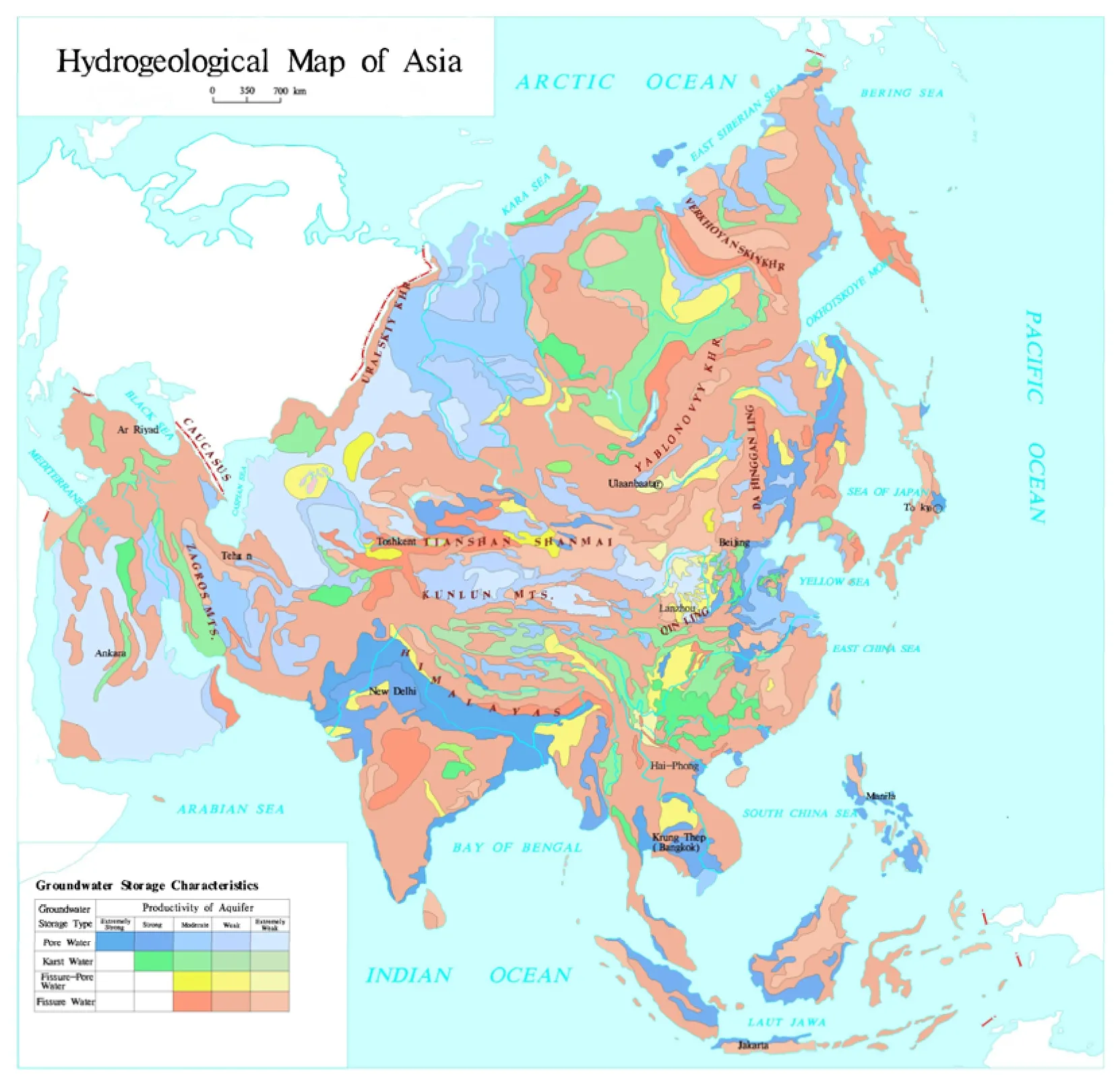
Fig. 1 Hydrogeological map of Asia
Groundwater Resources Map of Asia:It uses groundwater percolation theory to reveal the water-bearing characteristics of aquifer systems and analyzes the conversion between precipitation,surface water and groundwater. Based on the water-bearing characteristics and the seepage conditions, the map, mirrors the differences in groundwater seepage fields between loose continuous sedimentary aquifers and fracture confined water of bedrocks, karst fissure and cave discrete aquifers or other scattered aquifers.Groundwater is classified into: ① loose sedimentary continuous aquifers in plains, mountains and basins, ② bedrock discrete aquifers in hills and mountains, ③ other scattered aquifers. The map expounds on where precipitation is abundant enough to recharge groundwater and where it falls short, summarizes how groundwater resources are distributed and makes an evaluation on groundwater resources. It is the first time that groundwater in Asia is divided into 36 secondary groundwater systems under 11 primary ones according to ocean systems, climatic geomorphology, hydrogeological tectonic elements and major river systems. The map refers to the assessment results of other large regions (countries)to drive the study on trans-border aquifers up from quantitative level to qualitative level by adopting an unified module of natural recharge (runoff) as(104m3/km2·a). It develops a proper evaluation on natural recharge resources for groundwater and exploitable resources, offers a macro answer to on what level are groundwater resources can meet social demand and provides reliable data to the study on global groundwater resources (CHEN Meng-xiong and MA Feng-shan, 2002; DONG Hua et al. 2011).
The map fills in the global gaps in this kind of inter-continental map, and because it is practical and comprehensive, it serves as a foundation for resources development in Asian countries and across boundaries and river basins. Moreover, it is also applicable to territorial planning, research and education, the spread of science among men in the street and international academic exchange. Last but not the least, it generates a profound impact,both scientifically and politically, on the strategic demand in the entire world for a solution to bottlenecks posed by resources and environment.Fig. 2 is Groundwater Resources Map of Asia.
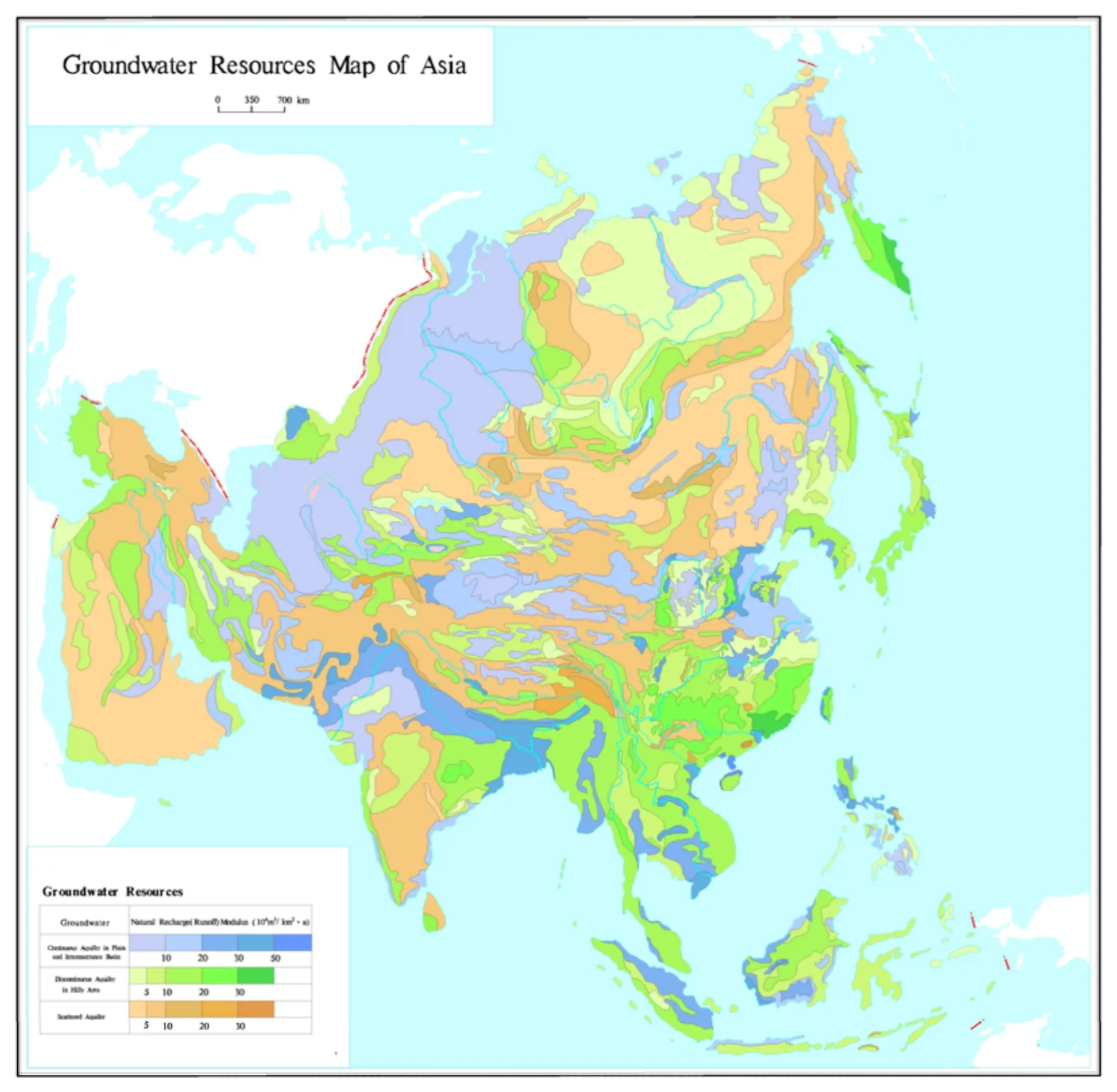
Fig. 2 Groundwater resources map of Asia
Geothermal Map of Asia:Based on the analysis of how the tectonic structure and volcano activities of Asia impact the distribution of thermal resources, the map divides thermal resources of Asia into three types-modern volcanoes, uplift fractures and sedimentary basins, a scientific revelation of the occurrence and distribution of such resources. It is the first to touch on the field of geothermal energy of Asia at the depth of 3 000 m and reveal how crustal movements such as tectonic structure and volcano activities are related to geothermal resources of Asia. It also shows representative geothermal exposure, such as hot springs, hot-water springs, hot-water wells, and the distribution of terrestrial heat flow values.
The map is the first of its kind, providing fundamental basis and practical value. It is highly valuable to researches on how geothermal resources are formed and macro planning for how to develop geothermal energy in Asian countries as it serves as a basis on which such study and planning can build. In all, it has a bright prospect and can bring visible social benefits. Fig. 3 is Geothermal Map of Asia.
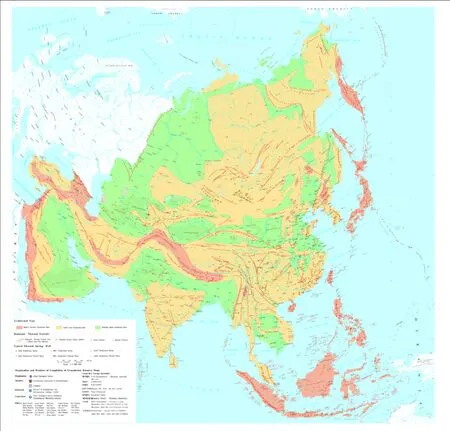
Fig. 3 Geothermal map of Asia
4.2 Profile of Groundwater Environment Serial Maps of Asia
As an important part of geo-environment,groundwater environment is a large dynamic environmental system with multiple layers,objectives and factors that impact and interact with each other. In the process of recycle, groundwater needs to undergo a long stretch of evolution of water-rock interaction as well as the water-rock and water-earth interaction before any quality and quantity changes, thus forming hydro-geochemical system which interacts with the groundwater in the basic groundwater environment, including primary(natural) groundwater environment and secondary(man-made) groundwater environment.
Groundwater Environment Serial Maps of Asia:In these maps, we have studied major geo-environmental issues of Asia from the perspective of development strategies in Asia drawing on the three thematic maps of groundwater quality of Asia, geological environment effect by groundwater development in Asia and ecological eco-environment of Asia (Fig.4, Fig. 5 and Fig. 6).
Among which,Groundwater Quality Map of Asia:It studies the impact of groundwater quality on water supply and health. By collecting data about groundwater salinity and the distribution characteristics of special chemical constituents in Asian countries and regions, the map analyzes the horizontal and vertical belts of specific elements under different hydro-geochemical effects. It also applies Analytic Hierarchy Process (AHP) to the evaluation of groundwater quality and studies groundwater quality distribution and hydrogeochemical characteristics of shallow groundwater in Asia. It first makes single-element maps regarding groundwater salinity, distribution of special chemical constituents (fluorine, arsenic,iron, manganese and radon), and shallow groundwater hydro-geochemical belts. The map uses AHP to assign values for overlay analysis,making a comprehensive evaluation of groundwater quality levels, and then compiles the Groundwater Quality Map of Asia by virtue of comprehensive analysis mapping method. (IGRAC,2009; WHO, 2005; SBTS, 1994, 2006)
AHP assignment rating assessment:The rating is mainly based on the levels of Total Dissolved Solids (TDS); degrading is determined by the distribution range of special chemical constitutes and the level of groundwater quality is evaluated by AHP.
Weight assignment of special chemical constituents: Value assignment based on experience about how much the constituents affect human health.
Total scores for special chemical constituents:add up weights of all chemical constituents.
Value assignment:
Levels of arsenic: 5 (5 as exceeding and 0 as not exceeding, and so on);
Levels of fluoride: 3;
Levels of iron and manganese: 1.
The ranking for groundwater quality is divided into: Good; relatively good; average; relatively bad;bad. The table of Groundwater Quality Ranking is shown as follows.
The study and evaluation on groundwater quality across an area as large as a continent is still in its inception and the map is the first of its kind both at home and abroad. It is the first to take into consideration geochemical features and chemical elements when evaluate groundwater quality. In doing so, it collected data about groundwater salinity and special chemical components for overlay analysis and, for the first time, uses AHP in groundwater quality evaluation. The map displays horizontal and vertical belts under different hydro-geochemical effects and analyzes how different quality levels and special elements are distributed and why they are formed in this way,thus revealing how climatic geomorphology,groundwater occurrence type and environment impact and control groundwater quality and the distribution of special elements in this region. The map also offers a scientific basis for resources development, water resources planning and protection to Asian countries, and gives reference to international study in hydrogeology (ZHANG Zong-hu and SU Ji-chao, 2006).
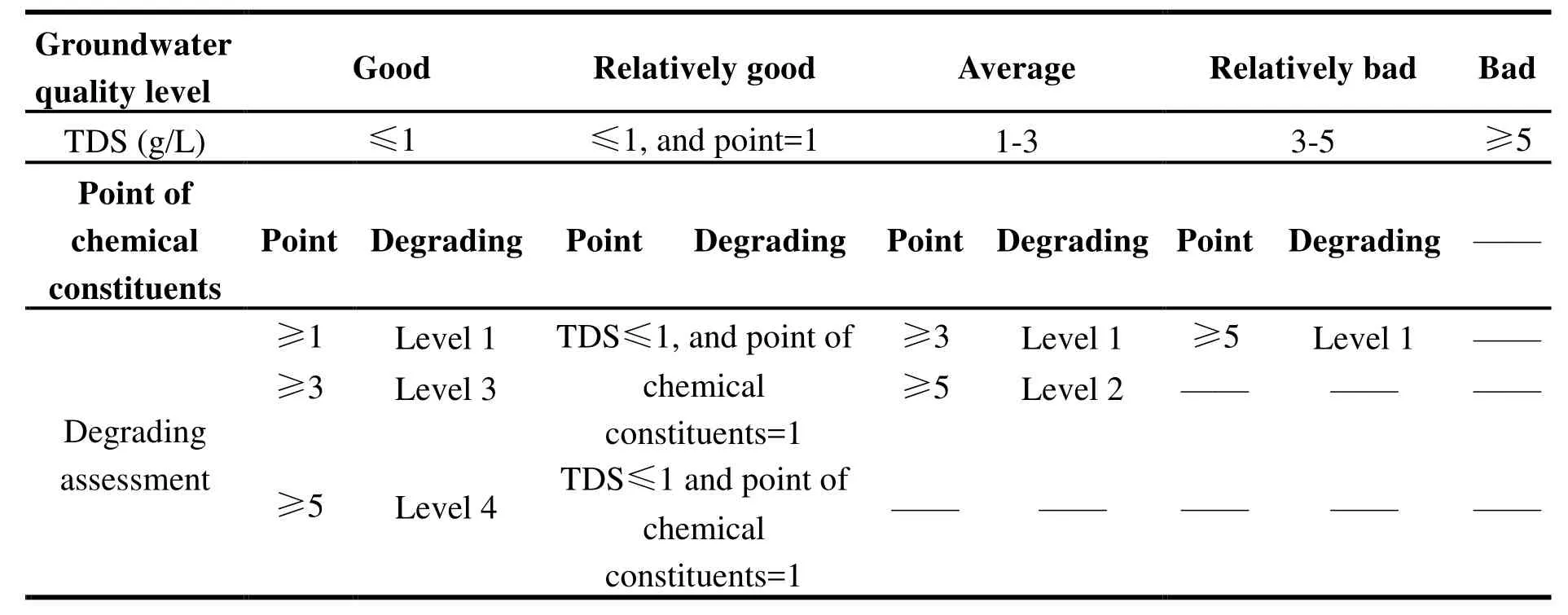
Table1 Groundwater quality ranking
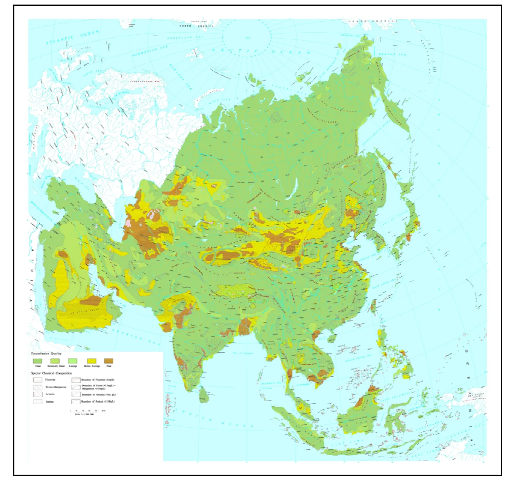
Fig. 4 Groundwater quality map of Asia
Map of Geological Environmental Effect by Groundwater Development in Asia:Through macro analysis, it classifies negative impacts of irrational development of groundwater on geo-environment into 7 categories: Constant decrease of regional groundwater level, land subsidence, karst collapse, ground fracture,saltwater intrusion, decrease of water level when mining groundwater in oil fields and mining collapse. Based on groundwater exploitation, the distribution of population and large reservoirs, the geo-environmental impact on groundwater development of Asia can be divided into 6 zones:The large-scale hazard-affected zone caused by heavy groundwater exploitation in plains and basins, the affected zone without obvious hazard caused by normal groundwater exploitation in plains and basins, the hazard-prone zone caused by the partially karst groundwater exploitation, the hazard-prone zone caused by groundwater dewatering in mining area, the affected zone without obvious hazards for the groundwater is exploited separately in hills and mountains and other normal affected zones with sporadic groundwater exploitation.

Fig. 5 Map of geological environmental effect by groundwater development in Asia
There is no precedent to Geo-Environmental Impact Map for Groundwater Development of Asia which illustrates negative effects on geo-environment caused by groundwater exploitation on inter-continental scale and how these effects are distributed. It leads to the zoning based on types of geo-environmental effects and intensity, and explores key factors closely related to groundwater exploitation. With the map, it is possible to give advisable solutions and suggestions to how to develop and use groundwater in a proper way that contributes to China’s development and surrounding regions. As the basis for global study on changes in this field,the map serves macro decision making and territorial management in and around China.
Groundwater Ecological Environment Map of Asia:The map draws upon favorable techniques of the rest of the world to solve pressing geo-environmental issues in and around China. It learns from advanced practices from outside to upgrade its own techniques. It studies the nature and basic features of groundwater geoenvironment and applies images overlay analysis to arrange the legend system and trial edition (LI Jia-xi and WU Gong-jian, 1999).
The map taps on the impact of human activities on ecological geo-environment, including soil salinization, desertification, shrinking of water,changes in the scope of frozen crust, etc. and divides groundwater eco-environment into 3 types:Basin-based groundwater eco-environment,mountain and plateau-conserved groundwater environment, and vulnerable eco-environment caused by a lack of groundwater.
The map is the first of its kind both at home and abroad. It pioneers in depicting how groundwater and eco-environment interact with each other in space over time on an inter-continental scale, which leads to the idea in mapping which relies on the climatic geomorphology and quality of ecological environment as well as the groundwater conservation and its supporting role. In doing so,the map divides groundwater environment into 3 types: ① groundwater storage-boosted ecoenvironment; ② groundwater conservationpreserved eco-environment; ③ groundwater shortage-vulnerable eco-environment. The map reveals that groundwater coexists with ecoenvironment before displaying main features and functions of 10 groundwater eco-environment zones.

Fig. 6 Groundwater ecological environment map of Asia
5 Innovations
The serial maps are the first to classify groundwater system of Asia. Standards for macro groundwater system classification mainly based on the climatic geomorphology were proposed, which has expanded the theory of groundwater system.With such factors as climatic geomorphology tectonic structure, hydrogeological structure and surface water system considered, groundwater of Asia is divided into 36 secondary systems under 11 primary ones.
The maps reveal how groundwater of Asia cycles. They identified the groundwater types and quantity in Asia, and divided the groundwater in Asia into the following types: pore water, karst water, fissure water and pore-fissure water.Geothermal resources are divided into modern volcanoes, uplift fractures and sedimentary basins,which helped us understand terrestrial heat flow value and how geothermal energy is naturally distributed across the geothermal field at the depth of 3 000 m.
(1) A mathematical model is created to quantitatively evaluate how trans-boundary aquifers agree with each other. The maps saw the creation of quantitative technical criteria and indicator system of the degree of harmony among trans-boundary aquifers of Lancang River-Mekong River, and the creation of a mathematical model which adds up weights of the three indicators-transboundary aquifers natural function indicator, social and economic management indicator and legal effect indicator-to quantitatively evaluate the degree of harmony among transboundary aquifers, not just qualitatively, as was before.
(2) A scientific method, AHP, is used in comprehensive evaluation of the quality of groundwater on an inter-continental scale. It is the first time that geochemical characteristics and chemical components are considered in this process. The groundwater quality is rated through overlay analysis on the groundwater salinity and special chemical elements by applying AHP.
(3) The maps elaborate on the negative geo-environmental effect caused by groundwater development on an inter-continental scale and the distribution of such effect. The 7 types of negative geo-environmental effect are divided into 6 zones based on the distribution of the effect intensity.The maps also attempted to explore key factors closely related to groundwater exploitation and utilization.
(4) The ecosystem comes into connection with groundwater on an inter-continental scale. The maps display how groundwater and ecoenvironment interact with each other in space over time, and pioneer in the idea in mapping which relies on the climatic landforms and quality of ecological environment as well as the groundwater conservation and its supporting role. In doing so,the map divides groundwater ecological environment into 3 types.
(5) The maps further advance groundwater and environment spatial information technology based on multi-mode temporal-spatial integrated cognition and build a spatial information system for groundwater resources and environment of Asia, a breakthrough for future map compilation and study techniques of intercontinental groundwater and environment. They manage to match unaligned information units from different basins,countries and regions on an inter-continental scale.They coordinate multi- temporal spatial information cognition of different ages and periods of time. Also, they standardized the expressions in maps of 10 types of climatic geomorphology, 4 types of aquifers, 3 types of groundwater resources,3 types of geothermal reservoir, 5 levels of groundwater quality, 7 types of negative geo-environmental effects and 3 types of groundwater eco-environment, making them delivered in proper layouts and delicate manifestation that are pleasant to the eye and easy to understand.
Groundwater Serial Maps of Asia and Groundwater Environment Serial Maps of Asia generate a far-reaching impact on the hydrogeological world as they offer scientific justifications for natural resources exploitation and water resources planning and protection by carrying on the theories and approaches of various studies on groundwater mapping, and adding new things to them as well.
6 Application and prospects
Groundwater Serial Maps of Asia, ever since their publication, have been extensively applied in concerned organizations and institutes both at home and abroad as basic references for resources development, water resources planning, geoenvironmental protection, climate change study,disaster prevention and relief and strategic development of clean energy within and across Asian countries. Organizations that have used the maps include: International organizations, foreign research institutes and administrative bodies like the UNESCO, Department of Groundwater Resources of Thailand, Ministry of Energy and Mines of Laos, Ministry of Energy and Mineral Resources of the Republic of Indonesia, Myanmar Ministry of Resources, Moscow State University,Hanoi University of Mining and Vietnam Academy of Science and Technology. Domestically, Chinese Academy of Sciences, Ministry of Land and Resources, universities and local organizations have found the maps valuable in research, teaching and administrative planning. The UNESCO Thailand Office referred to the maps when it was compiling groundwater serial maps for Mekong River basin, Greater Mekong River basin and ASEAN countries. The CGS has utilized the maps as essential material basis in compiling “One Belt One Road” energy and mineral resources atlas and groundwater resources and environment survey along the Silk Road Economic Belt.
Groundwater Serial Maps of Asia and Groundwater Environment Serial Maps of Asia are basic, comprehensive and widely applicable. This great achievement will play a significant role in water resources study in Asia and even in the whole world, as it provides scientific basis for coordinated global economic growth, establishment and implementation of national development strategies, water resources allocation optimization and environment protection, and offers a scientific guidance in carrying out the “One Belt One Road”strategy and in advancing ecological progress. To sum up, the maps are valuable, both scientifically and politically, to the strategic demand in the entire world for a solution to bottlenecks posed by resources and environment, which, in turn, drives exchanges among countries that will finally contribute to the future of hydrogeology.
杂志排行
地下水科学与工程(英文版)的其它文章
- Groundwater ecological environment and the mapping of Asia
- Groundwater system division and compilation of Groundwater Resources Map of Asia
- Processes of hydrogeochemical evolution of groundwater in the Guanzhong Basin, China
- Governance of protected areas: Kara Kara National Park, Victoria
- Comparison of 1,2,3-Trichloropropane reduction and oxidation by nanoscale zero-valent iron, zinc and activated persulfate
- Evaluation on water resources carrying capacity of Changchun-Jilin Region
