Groundwater system division and compilation of Groundwater Resources Map of Asia
2015-12-12CHENGYanpeiDONGHua
CHENG Yan-pei, DONG Hua
Institute of Hydrogeology and Environmental Geology, CAGS, Shijiazhuang 050061, China.
Abstract: Based on landform, climate, river system, geological structure and hydrogeological structure and from the perspective of systematology, the groundwater system of Asia can be divided into 36 secondary groundwater systems under 11 primary ones by the intercontinental scale. A scientific evaluation of groundwater resources in Asia can be secured using water balance method and runoff modulus method through water circulating analysis and feature study of groundwater system on the basis of groundwater system division of Asia. With natural recharge (runoff) modulus (104m3/km2·a), the total amount of water resources and those available for exploitation of primary groundwater system can be evaluated-continuous aquifers in plains and basins contain 242.465×10⁹ m3/a of water, 169.725×10⁹ m3/a of which is recoverable; discrete aquifers contain 186.695×10⁹ m3/a, 130.686×10⁹ m3/a of which is available for exploitation; other scattered aquifers contain 38.614×10⁹ m3/a, 27.029×10⁹ m3/a of which could be exploited. In total, there is 467.774×10⁹ m3/a of groundwater with 327.440×10⁹ m3/a recoverable. The groundwater map of Asia is compiled according to groundwater system division, evaluation of the total amount and aquifer types to reflect the macro features of groundwater resources in Asia, laying a scientific foundation for exploitation and management of water resources here and for avoiding disputes over groundwater resources and environment among Asian countries.
Keywords: Asia; Groundwater system; Climate and topography; Resources evaluation;Groundwater resources map
Introduction
General systematology was put forward by Ludwig von Bertalanffy (1952) in the 1940s and its idea and method extend across the boundary of each and every discipline. J Toth drew a theoretical groundwater system in homogeneous isotropic phreatic water basin using analytical method in 1963, while in 1980, he was the first to discover the “gravity movement through layers” which applied the flow system theory to heterogeneous medium fields. Engelen G B (1986), professor from VU University Amsterdam, Netherland, took a step forward to point out the hydrosystem concept of combining the surface and ground water of a certain region. The advent of these theories served as a necessary analytical framework for hydrogeology. In 1974, Engelen believed that“groundwater system” could be regarded as such a living organism that absorbs, metabolizes and outputs different forms of energy from the beginning to the end of its “life”. It has such features as: ① boundary-like model; ② volume;③ structure; ④ resistance or the ability to transform potential energy; ⑤ outflow system; ⑥connection between adjacent systems; ⑦ water type and model; ⑧ the development “history” of groundwater system. Ralf C Hays from the United States Geological Survey Hydrology Department believed that “groundwater system” refers to the earth crust from water table to the bottom of the rock fracture zone, a place for groundwater storage and movement.
Groundwater system serves as a time-place carrier for groundwater evaluation by taking groundwater as a whole when studying its amount,the way it was formed, and how it changes with place and time. It can be divided into several independent but interconnected sub-systems that help us understand such basic features of groundwater as wholeness, connection, hierarchy,dynamics, balance and time sequence. It is advisable to use systematology to study the relations between all the elements of groundwater and the surrounding environment so as to assess the amount of groundwater (CHEN Zhi-ming,2010).
1 Groundwater system division of Asia
1.1 Classifying principles and basis
The classifying principles and method of groundwater system must conform to the scale effect as they go beyond just learning about the features and rules of groundwater system to reflecting the system’s hierarchy, structure and evolution, and most importantly, its input and output functions. Such principles should be systematic, intercontinental, independent and easy for macro planning and management (DONG Hua et al. 2011).
Around water system of Asia belongs to intercontinental scale, and the division is based on tectonic framework. Continental vapor flux is controlled by climate and landform while rainfall exerts significant influence on regional water circulating, so the application of intercontinental scale in the formation, distribution and movement of groundwater can result in both horizontal and vertical zoning. Therefore, we should first find out the tectonic framework, climate, rainfall distribution and landform of the Asian continent.Asian climate zoning controls the vapor of atmospheric circulation and atmospheric precipitation is the main source of groundwater, so different climate zoning has different annual average precipitation over the years (Fig. 1).Moreover, groundwater recharge depends on precipitation, and groundwater system is dramatically influenced by climate change. The precipitation in different regions can result in varying groundwater recharges due to the influence of time,space and water-bearing medium. Meanwhile, the tectonic landform can bring about different climate-landform combination due to different climate conditions and external force (Fig. 2)(ZHANG Fa-wang et al. 2012).
1.2 Groundwater system division of Asia
The groundwater system, a place for groundwater formation, movement and evolution, is the carrier for groundwater resources input and output.According to the tectonic structure, climate zoning and landform of the Asian scale, groundwater system of Asia can be divided into 11 primary systems which include 36 secondary ones (Fig. 3).
ⅠGroundwater system in tableland and plateau of cold temperate zone includes: Groundwater system in Ob River Basin of west Siberia Plain, groundwater system in Yenisei River Basin of Central Siberia Plateau, groundwater system in Lena River Basin of Central Siberia Plateau,groundwater system in Kolyma River Basin of Eastern Siberia.
Ⅱ Groundwater system in temperate semihumid upland and plain of northeastern Asia includes: Groundwater system in Heilongjiang River (Amur River), groundwater system in Liaohe River Plain-Korea Peninsula, groundwater system in islands of Northeastern Asia.
Ⅲ Groundwater system in upland of North China Plain and temperate semi-arid area of Loess Plateau includes: Groundwater system in Huang-Huai-Hai Plain-Shandong Peninsula, groundwater system in Shanxi-Hebei intermontane basin,groundwater system in Ordos-Loess Plateau.
Ⅳ Groundwater system in temperate arid area of inland basin and hilly area includes: Groundwater system in Mongolia Plateau, groundwater system in Hexi Corridor, groundwater system in Ili River Basin-Junggar Basin, groundwater system in Kazakhstan hilly area-Tulan Plain, groundwater system in Qaidam Basin, groundwater system in Tarim Basin.

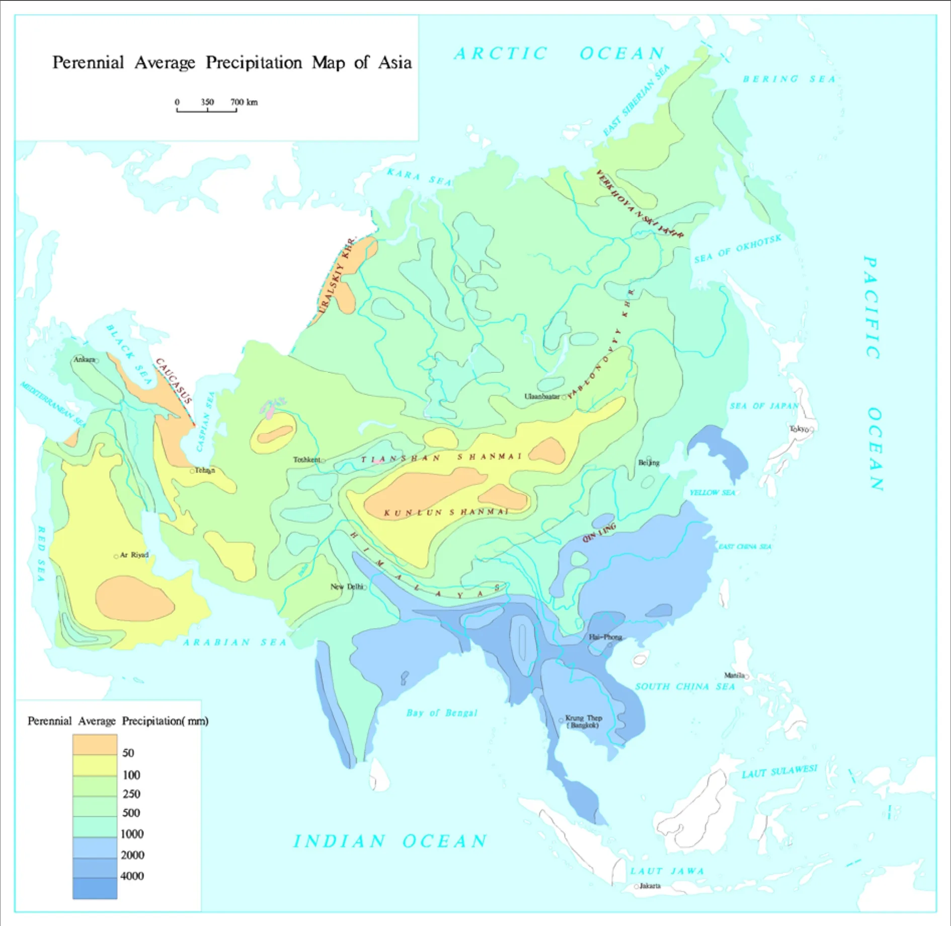
Fig. 1 Climate types map and perennial average precipitation map of Asia
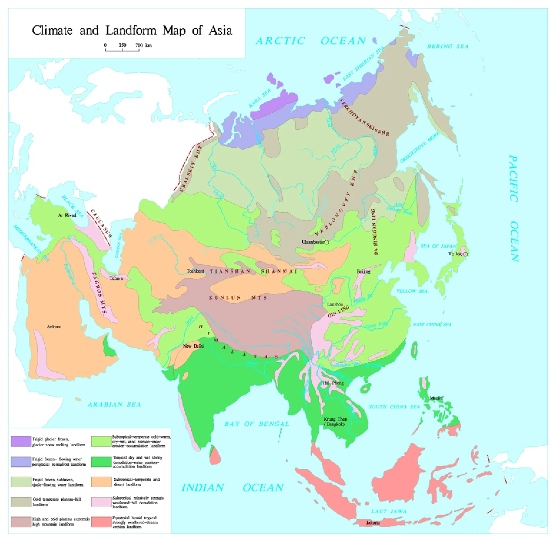
Fig. 2 Climate and landform map of Asia
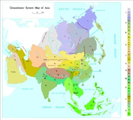
Fig. 3 Groundwater system map of Asia
Ⅴ Groundwater system in tropic arid semihumid area of Iran Plateau-Asia Minor Peninsula includes: Groundwater system in Asia Minor Peninsula (Anatolia Plateau) and groundwater system in Iran Plateau.
Ⅵ Groundwater system in tropic-arid area of Arabian Peninsula-Mesopotamian plain includes:Groundwater system in Mesopotamian Plain and groundwater system in Arabian Peninsula.
Ⅶ Groundwater system in frigid zone of Qinghai-Tibet Plateau includes: Groundwater system in Kashmir-Himalaya-Qiangtang Plateau and groundwater system in southern Tibet Valley.
Ⅷ Groundwater system in tropic humidsemi-humid zone of India River-Ganges River Plain-Deccan Plateau includes: Groundwater system in India River Plain, groundwater system in Ganges River Plain, groundwater system in India Peninsula.
Ⅸ Groundwater system in tropic humid upland of Indo-China Peninsula includes: Groundwater system in upland and plain of Lancang River-Salween River Basin, groundwater system in upland and plain of Lancang River-Mekong River Basin, groundwater system in upland and plain of Red River Basin.
Ⅹ Groundwater system in subtropic humid hilly area of South China includes: Groundwater system in Qinling-Dabieshan Mountains, groundwater system in terraced terrain of west Sichuan Plateau, groundwater system in Sichuan Basin,groundwater system in hilly area of middle and lower reaches of the Yangtze River, groundwater system in karst upland of South China, groundwater system in coastal hilly area and islands of South China.
Ⅺ Groundwater system in equatorial humid islands of southeastern Asia includes: Groundwater system in Malay Peninsula, groundwater system in islands of Southeast Asia.
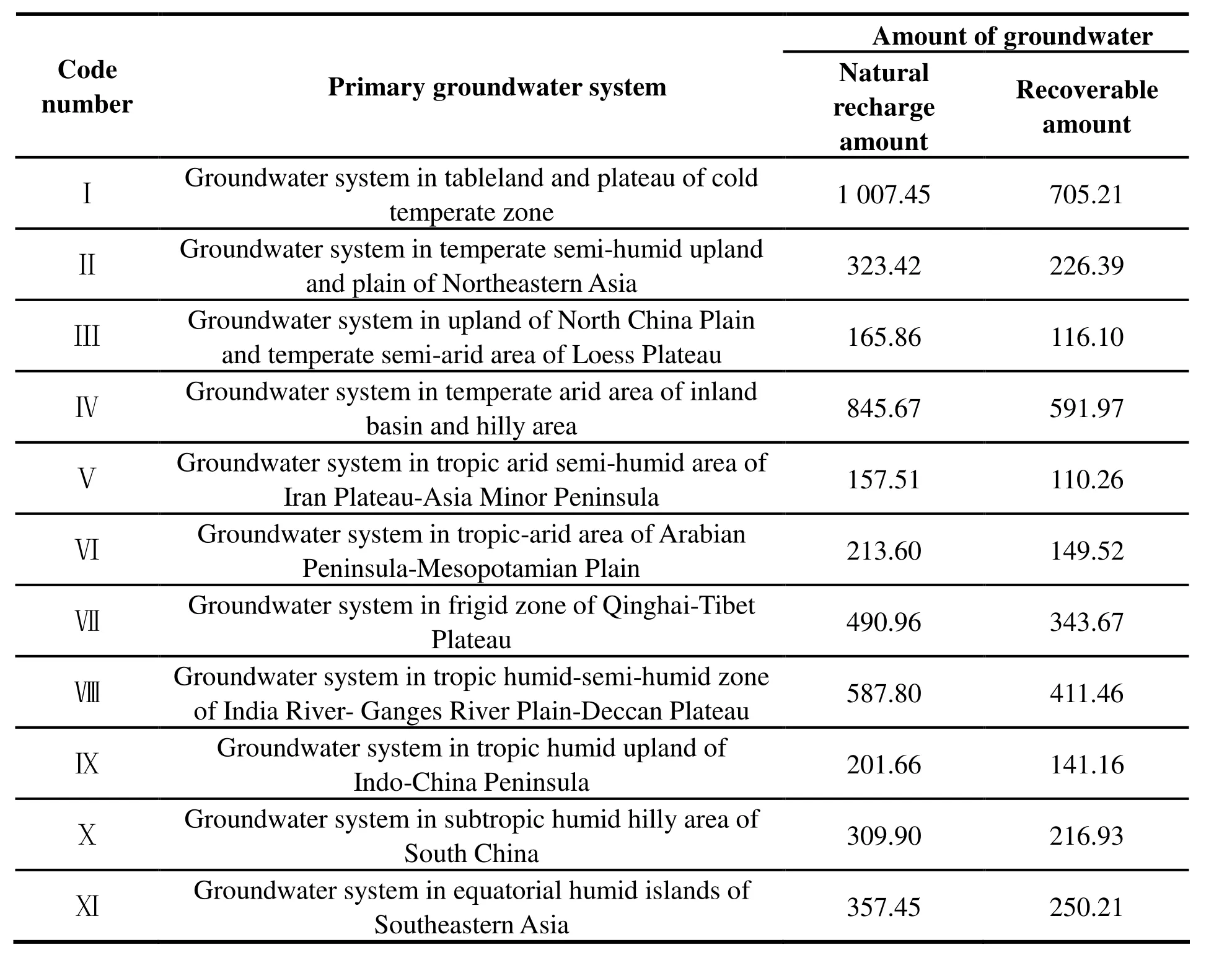
Table 1 Groundwater system of Asia
2 Evaluation of groundwater resources in Asia
First of all, we need to get the partition of coefficient of groundwater infiltration based on differences in such infiltration recharge conditions as landform, annual average precipitation,hydrology, the lithology of vadose zone and water-bearing medium and convert groundwater recharge intensity (mm/a) into groundwater natural recharge (runoff) modulus. Meanwhile, the transformation between surface water and groundwater should play a role in evaluating the surface water recharge zone in plains and basins,especially the Siberia Plain hills where the recharge water amount of seasonal frozen layer increases sharply at alterations of freezing and thawing. In terms of groundwater flowing continuity, aquifers could be classified into: ①Plain, intermittent basin loose sediments,Continuous water-bearing system ② Hills,mountains, Discontinuous water-bearing system③ Other water-bearing system; the groundwater natural recharge modulus (104m3/a·km2) of the 3 kinds of aquifers can be ranked into five levels:<10,10-20, 20-30, 30-50 and >50.
This paper unprecedentedly divides Asia into 11 primary groundwater systems and 36 secondary systems on a macro scale. The analysis of the precipitation figures of each region to which a primary system belongs, coupled with that region’s own landform, annual average precipitation,hydrology, the lithology of vadose zone and waterbearing medium, leads to the conversion of groundwater recharge intensity into groundwater natural recharge (runoff) modulus used in the runoff modulus method to eventually get the natural recharge water amount of each primary system (Table 1).
Total groundwater amount of the 3 kinds of aquifers calculated through runoff modulus method(Table 2).
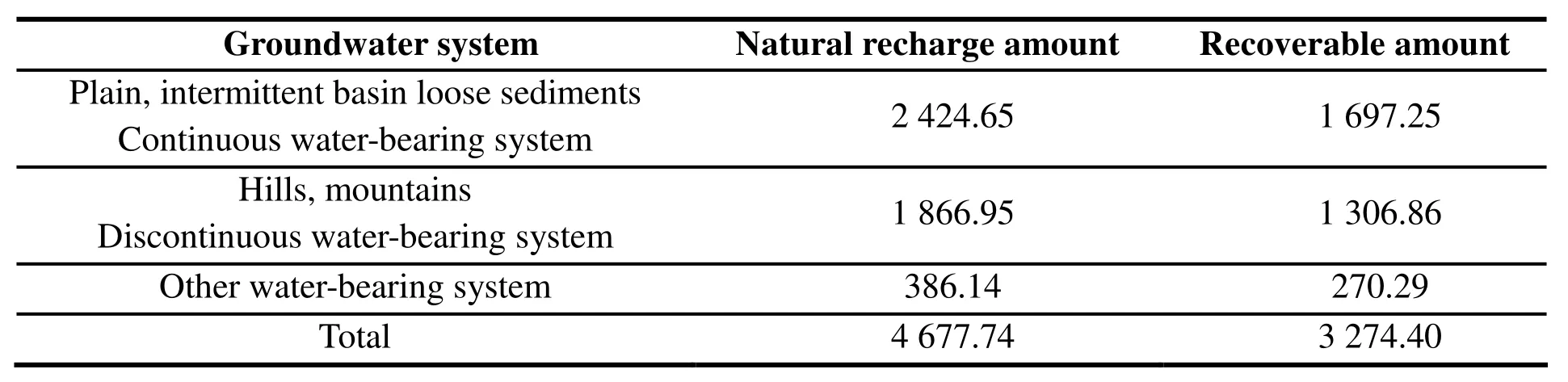
Table 2 Total amount of groundwater in Asia (108 m3/a)
A look at Table 2 reveals that groundwater distribution in Asia is extremely uneven. Other water-bearing system has 38.614×10⁹m3/a of natural recharge amount, accounting for mere 8%of the total amount of groundwater in Asia, while plain, intermittent basin loose sediments, continuous water-bearing system and hills, mountains,discontinuous water-bearing system represent 52%and 40% respectively. The reason why plain,intermittent basin loose sediments, continuous water-bearing system take up the largest amount is that Asia houses many such aquifers that have relatively big groundwater recharge modulus.
At the core of groundwater resources evaluation, the recoverable amount is mainly up to recharge amount, though it is also related to both economic and technological conditions and plans of exploitation. This paper takes into consideration the hydrogeological conditions of the region that a certain system belongs to, groundwater exploitation conditions as well as the utilization degree before multiplying the coefficient of exploitation experience 0.7 to natural recharge amount of that system to get its recoverable amount.
3 Compilation of groundwater resources map
The map contains: groundwater (system) division, groundwater type, groundwater natural recharge modulus, total amount of groundwater,recoverable amount and the amount of deep groundwater that can be exploited (Fig. 4).
Groundwater division: mainly based on ocean systems, climate and landform, hydrogeological tectonic units and major river systems but also refers to the results of groundwater evaluation of different regions (countries) (Fig. 4).
4 Conclusions
As part of the work of compilation of groundwater map, this paper divides the Asian groundwater system based on hydrogeological conditions in Asia and applies systematology to such major elements as Asian climate, landform,tectonic structure, hydrogeological conditions and surface water systems, leading to a successful division on an intercontinental scale and enriching the groundwater system theory. Through groundwater infiltration theory, this paper also reveals the storage characteristics of groundwater systems. By analyzing the transformation among rainfall, surface water and groundwater, it makes a scientific evaluation of Asian groundwater resources through water balance method and runoff modulus method-continuous aquifers in plains and basins have 242.465×10⁹m3/a of groundwater with 169.725×10⁹m3/a recoverable; discrete aquifers contain 186.695×10⁹m3/a, 130.686×10⁹m3/a of which is available for exploitation; other scattered aquifers contain 38.614×10⁹m3/a, 27.029×10⁹m3/a of which could be exploited. In total, there are 467.774×10⁹m3/a of groundwater with 327.440×10⁹m3/a recoverable. These figures represent the features of groundwater in Asia in a macro way, offering a scientific basis for groundwater exploitation, planning and management in Asia.
Acknowledgements
This study is supported by Geological Map of Groundwater Resources and Environment of China and Surrounding Areas (12120113014200) and Series Maps of Karst Environment Geology of China and South East Asia (12120114006401,12120114006301).
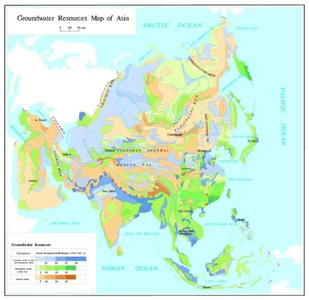
Fig. 4 Groundwater resources map of Asia
杂志排行
地下水科学与工程(英文版)的其它文章
- Analysis of the negative effects of groundwater exploitation on geological environment in Asia
- Specific yield of phreatic variation zone in karst aquifer with the method of water level analysis
- Application of remote sensing technique to mapping of the map series of karst geology in China and Southeast Asia
- Compilation of Groundwater Quality Map and study of hydrogeochemical characteristics of groundwater in Asia
- Evaluation on water resources carrying capacity of Changchun-Jilin Region
- Comparison of 1,2,3-Trichloropropane reduction and oxidation by nanoscale zero-valent iron, zinc and activated persulfate