The Coordinated Influence of Indian Ocean Sea Surface Temperature and Arctic Sea Ice on Anomalous Northeast China Cold Vortex Activities with Different Paths during Late Summer
2023-02-08YitongLINYiheFANGChunyuZHAOZhiqiangGONGSiqiYANGandYiqiuYU
Yitong LIN, Yihe FANG*, Chunyu ZHAO, Zhiqiang GONG, Siqi YANG, and Yiqiu YU
1Regional Climate Center of Shenyang, Liaoning Provincial Meteorological Administration,Shenyang 110016, China
2Key Opening Laboratory for Northeast China Cold Vortex Research, China Meteorological Administration,Shenyang 110016, China
3College of Physics and Electronic Engineering, Changshu Institute of Technology, Changshu 215500, China
4Laboratory for Climate Studies, National Climate Research Center, China Meteorological Administration,Beijing 100081, China
5Inner Mongolia Climate Center, Hohhot 010051, China
ABSTRACT The Northeast China cold vortex (NCCV) during late summer (from July to August) is identified and classified into three types in terms of its movement path using machine learning.The relationships of the three types of NCCV intensity with atmospheric circulations in late summer, the sea surface temperature (SST), and Arctic sea ice concentration (SIC) in the preceding months, are analyzed.The sensitivity tests by the Community Atmosphere Model version 5.3 (CAM5.3) are used to verify the statistical results.The results show that the coordination pattern of East Asia-Pacific (EAP) and Lake Baikal high pressure forced by SST anomalies in the North Indian Ocean dipole mode (NIOD) during the preceding April and SIC anomalies in the Nansen Basin during the preceding June results in an intensity anomaly for the first type of NCCV.While the pattern of high pressure over the Urals and Okhotsk Sea and low pressure over Lake Baikal during late summer-which is forced by SST anomalies in the South Indian Ocean dipole mode (SIOD) in the preceding June and SIC anomalies in the Barents Sea in the preceding April-causes the intensity anomaly of the second type.The third type is atypical and is not analyzed in detail.Sensitivity tests, jointly forced by the SST and SIC in the preceding period, can well reproduce the observations.In contrast, the results forced separately by the SST and SIC are poor, indicating that the NCCV during late summer is likely influenced by the coordinated effects of both SST and SIC in the preceding months.
Key words: machine learning method, Northeast China cold vortex, path classification, Indian Ocean sea surface temperature, Arctic sea ice, model sensitivity test
1.Introduction
As an important part of the atmospheric circulations in the middle- and high-latitudes of the Northern Hemisphere,the Northeast China cold vortex (NCCV) has an important influence on the persistence and adjustment of atmospheric circulation anomalies in Northeast China (NEC) and in East Asia.This pattern can occur all year round, with the highest frequency of occurrence in the spring and summer (Sun etal., 2000; Huang and Li, 2020).The frequent NCCV activities are the primary cause of the meteorological disasters in the NEC (i.e., rainstorms, short-term heavy precipitation, and low-temperature damage), which have significant impacts on agricultural production, transportation, and people's lives(Sun et al., 2002).Therefore, it is very important to diagnose and accurately predict the NCCV anomaly.
Previous research mainly included the objective identification and climatological characteristics of the NCCV and the causes of the NCCV anomaly.In terms of climatological characteristics, many statistical analyses have been conducted on the occurrence frequency, duration, change trend, period,and spatial distribution of the cold vortex in previous studies(Sun, 1997; Liang et al., 2009; Hu et al., 2011; Xie and Bueh, 2012; Liu et al., 2015).As for the cause of the NCCV anomaly, some studies have been performed from the perspective of atmospheric circulation factors (Liu et al., 2002; He et al., 2006; Miao et al., 2006; Xie and Bueh, 2012).Lian et al.(2010) analyzed the relationship between NCCV activity in early summer and the atmospheric circulations in the Northern Hemisphere and pointed out that anomalous NCCV activity in the early summer is related to the persistent circulation anomalies near the Ural Mountains and Japan.Xie and Bueh (2017) revealed the dynamic features of the coordinated influence between the NCCV and the blocking high on the climate in NEC and its relation with the climatic circulation background on intra-seasonal time scales.Liu et al.(2016)and Yang et al.(2015a) explored the close relationship between the NCCV and the Okhotsk high and its response to early signals of El Niño-Southern Oscillation (ENSO).In addition, the NCCV anomaly is also related to the western Pacific subtropical high and the upper-level jet (Parker et al.,1989; Sun, 1997; Sun et al., 2000).Moreover, it is also influenced by sea surface temperature (SST) and land surface thermal anomalies (Bueh and Xie, 2013; Chen et al., 2018;Wang et al., 2018).Fang et al.(2018) conducted diagnostic analyses and numerical simulations on the precipitation anomalies in NEC in early summer.They point out that the North Atlantic tripole (NAT) SST and the SST anomalies in the Kuroshio area induce circulation anomalies, such as the anomalous blocking high located upstream and downstream of the NCCV through the air-sea interaction, further affecting the cold vortex precipitation in NEC in early summer.Lu et al.(2020) analyzed spring precipitation in NEC and revealed the physical mechanisms related to the interannual variabilities of the tropical North Atlantic and Northwest Pacific SST affecting the low-pressure system over the NEC in spring.Fang et al.(2020) analyzed the north-south position of the NCCV in early summer and pointed out that the SST in the northwestern Pacific and the southeastern Pacific in the preceding spring are the dominant factors causing more vortexes in the north, while the NAT SST in the preceding period is responsible for more vortexes in the south.
Most existing research mainly concentrates on the NCCV in early summer, while studies on the NCCV anomalies in late summer are quite rare.Previous studies have suggested that the summer monsoon is the dominant factor for the late summer precipitation in NEC, accounting for 70%-80% of the summer total (Shen et al., 2011).Current studies have revealed that the late summer precipitation is also affected by the circulation systems in middle and high latitudes (Shen et al., 2011) and that the influence of circulation systems such as the NCCV and blocking high on the late summer precipitation in NEC was enhanced after the mid-1980s(Lin et al., 2021).Sun et al.(2002) conducted a diagnostic analysis of nine typical heavy rainfall cases over the Songhuajiang-Nenjiang River Basin (SNRB) in the late summer of 1998 and found that the NCCV activity was abnormally frequent during that period.In addition, the configuration of the NCCV, the blocking high over East Asia and the West Pacific subtropical high, both in intensity and position, provide a favorable large-scale circulation background for persistent heavy rainstorms over the SNRB.Gao and Gao (2018)pointed out that the NCCV activity played a major role in the anomalously abundant precipitation over NEC during the 2013 summer.It can be seen that the diagnosis and the prediction of the NCCV anomaly in late summer are particularly important.The anomalous position of the NCCV could affect the temperature and precipitation in different regions of NEC (Fang et al., 2021).To meet the demand for an increasingly precise prediction of the NCCV, it is necessary to perform an objective classification for the NCCV in late summer in terms of its path and carry out research on the causes of various cold vortex anomalies.In this study, the NCCV is objectively identified based on the geopotential height and temperature data with a high spatiotemporal resolution (Fang et al., 2018), and the machine learning method of K-means is used to objectively classify the paths of the NCCV (Wang et al., 2018; Fang et al., 2021).The relationships of the NCCV along different paths in late summer with the atmospheric circulations during the same period, as well as the SST and Arctic sea ice concentration (SIC) in the preceding period, are investigated by using statistical analysis methods, and the possible mechanisms are also explored and discussed.Moreover, sensitivity tests are designed based on Community Atmosphere Model version 5.3 (CAM5.3) to verify the conclusions obtained by statistical analysis methods.
The remainder of this paper is organized as follows.Section 2 describes the data and methods used in this study.Section 3 presents the characteristics of the trajectories for NCCV.Section 4 presents the atmospheric circulations in late summer corresponding to various NCCV.Section 5 discusses the relationships of the NCCV in late summer with the precedent SST and SIC, and section 6 gives the results of numerical model sensitivity test.Finally, the findings of the present study are summarized and discussed in section 7.
2.Data and methods
2.1.Data
The research period in this study covers the late summers(from July to August) from 1979 to 2018.The data included the geopotential height and temperature data with spatiotemporal resolutions of 6 h and 1° × 1° from the European Centre for Medium-Range Weather Forecasts Re-Analysis Interim(ERA-Interim, Dee et al., 2011), the 500-hPa geopotential height with a resolution of 1° × 1° in the monthly reanalysis data came from ERA-Interim, the monthly SST data, and the monthly sea ice area fraction data with a horizontal resolution of 1° × 1° was provided by the Hadley Centre (Rayner et al., 2003).
2.2.Methods
In this study, the NCCV during mid-summer is objectively identified using the ERA-Interim geopotential height and temperature data from 1979 to 2018.See details of the identification method in Fang et al.(2021).
2.2.1.Calculation Method of the Indexes of the NCCV
The NCCV index is defined as the absolute value of the sum of the geopotential height anomaly of the lowest-value grid point within the inner equipotential height line of the cold vortexes in all the NCCV occurrence days in late summer from 1979 to 2018.In this way, the adopted index calculation method was not only able to reflect the number of cold vortex days but also represented the intensities of cold vortex centers.
2.2.2.NCCV Movement Path Classification based on the K-means Method
The objective classification method of the NCCV is given in the three steps below.
First, characteristic parameters were collected.According to the identification method of the NCCV, when we read the geopotential height and temperature data for each time into the script, the first time that meets the identification conditions is printed as the starting time of the cold vortex process, and the last time that meets the conditions is the ending time.The center position is defined as the grid point of the lowest geopotential height value within the inner equipotential height line of the cold vortex, while the generation and extinction positions are defined as the center position at the starting and ending time, respectively.Based on the objective identification results of the NCCV, the characteristic parameters for the NCCV processes in late summer are collected, including the latitudes and longitudes of the center positions from the starting times to the ending times.
Second, the trajectory description parameters were calculated.The generation position was collected to represent the source information of the cold vortex.Then, the meridional and zonal mean from the starting to ending times are calculated to describe the location of the cold vortex process.The meridional, zonal, and diagonal variances from starting times to ending times are calculated to describe the moving curvature and distance (e.g., a large diagonal variance corresponds to a straighter motion trajectory and a longer moving distance; see Zheng et al., 2013).The center positions of the cold vortex along its trajectory within the geographical scope of NEC are also collected to represent the relationship between its trajectory and the geographical location of NEC.The above parameters are preliminarily used to describe the trajectory of the NCCV.
Third, the cluster number is determined.The K-means clustering method is applied to the objective classification of the trajectories of cold vortexes.Before this, the value of the classification number, K, should be determined.Based on the dataset of trajectory describing parameters obtained in the previous step, two to seven initial classification numbers are preliminarily determined, and the shape coefficients corresponding to these classification numbers are calculated.The closer the shape coefficient is to 1, the more reasonable the classification number is, and thus an optimal classification number is determined.In this study, a classification number of three is selected.Thus, the NCCV is classified into three types in terms of trajectories.
2.2.3.Definition Indexes Used in This Study
The SST or SIC indices of the key areas were defined according to the regions where the correlation coefficient between the NCCV indexes in late summer and the SSTs or SICs in earlier months passed the 90% confidence level(see section 5).The specific definitions are given in Table 1.
2.2.4.Numerical model
The CAM5.3, as part of the Community Earth System Model version 1.2.2 (CESM1.2.2) modeling framework by the National Center for Atmospheric Research (NCAR), is used in this study to further verify the physical linkages between the previous SST (or SIC) and the late summer 500-hPa geopotential height field.This model has been used in previous studies of climate over East Asia (Huang et al.,2019; Zhang et al., 2020).The finite-volume dynamical core configured with a horizontal resolution of 1.9° latitude ×2.5° longitude (f19_f19) and 30 vertical hybrid levels is selected.More details about this model can be found in Neale et al.(2012).
Nine sets of numerical simulation experiments are conducted to examine the correlations of the SST and SIC in the preceding period with the 500-hPa geopotential height field in late summer.In the control experiment, the monthly climatological data is used as the initial field, while the model integration starts on 1 January of the first year.In the anomaly experiment, the output from 1 January in the sixth year in the control experiment is used as the initial field,with the SST (SIC) anomaly added to the SST (SIC) key areas in the corresponding months for each year.For SST,the sums of the climatic state and twice the regression coefficients calculated by the observed SST regressing onto the SST indexes in key areas were used as the anomalies.For the SIC, the regional averages of sea ice area fraction in the key areas from 1979 to 2018 are calculated.Then, the min and the max regionally-averaged values during these 40 years were selected, and the ice area fractions replaced by the maximum or minimum in the key areas for each gridwere used as anomalies.The specific designs are shown in Table 2, and the corresponding SST (SIC) key areas are shown in Table 1.All sets of experiments are continuously integrated into the fifteenth year.During the integration, the SST (SIC) anomaly remains unchanged.The model results from the sixth year to the fifteenth year are selected for significance tests of differences.
Table 2 summarizes the details of all experiments.The difference between the result from the anomaly experiment adopting SST1 (SST2) and that from the control experiment adopting SSTc was regarded as the influence of SST anomaly in the key area on atmospheric circulations at 500 hPa in late summer.The difference between the experimental result adopting SICMax1 (SICMax2) and SICMin1(SICMin2) was regarded as the influence of SIC anomaly in the key area of atmospheric circulations in the late summer.Moreover, the difference between the results of experiments adopting SSTSIC1 (SSTSIC2) and SICMin1 (SICMin2)was regarded as the combined effect of SST and SIC in the key areas of atmospheric circulations in late summer.
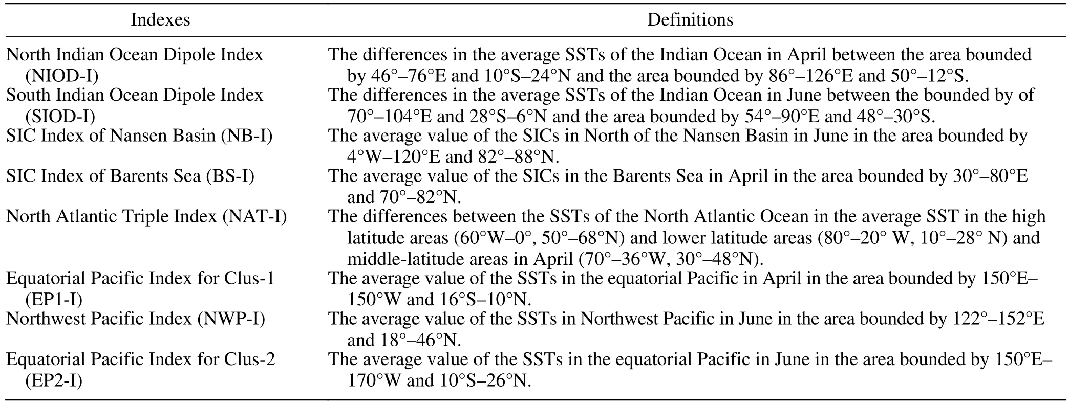
Table 1.Definitions of the SST and SIC indexes.

Table 2.The forcing areas and months of SST or SIC anomaly for nine experiments using the CAM5.3 atmospheric model.
In addition, statistical methods, including linear correlation analysis, partial correlation analysis, regression analysis, and composite analysis methods, are also used.By establishing a regression equation of the NCCV intensity index in late summer with the SST (SIC) index in the key area, the variance ratio between the regression result and the observed NCCV intensity was calculated as the contribution rate of the SST (SIC) in the preceding period to the NCCV intensity in late summer (Shi, 2002).
3.Characteristics of the trajectories for various NCCV
Based on the K-means clustering method, the above-mentioned NCCV processes in late summer are classified into three types in terms of the trajectories, and the results are shown in Fig.1.It can be seen that the first type of NCCV is mainly generated near the Stanovoy Range in eastern Russia.After a short distance of southward or southeastward movement, most of the NCCV dissipates in the northeastern part of NEC.The scope of vortex activities in NEC is limited to the northern part.Therefore, these types of vortexesmainly affect the northeast portion of NEC, and they are classified as the short-distance southeastward-moving type(Clus-1).The second type of NCCV is generated near Lake Baikal, and most of these move eastwards to large areas of NEC, except for part of the southern region, which tends to affect most of NEC.Therefore, this type of NCCV has the greatest impact on NEC among the three types and thus is the most noteworthy type.Due to the long-distance movement, they are classified as the long-distance eastward-moving type (Clus-2).The third type of NCCV is mostly generated in China, with its activities generally limited to NEC and its surrounding areas.Due to the short-distance movement, this NCCV is classified as the short-distance eastwardmoving type (Clus-3).
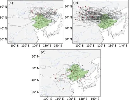
Fig.1.Paths of three types of NCCV activities in late summer, (a) Clus-1, (b) Clus-2, (c) Clus-3.The original locations are marked in red, the dissipation locations are marked in blue, and the black lines are the trajectories.
Figure 2 shows the spatial distributions of occurrence days for the three types of cold vortexes.Clus-1 mainly occurs in areas east of Lake Baikal to NEC, with the largevalue area of occurrence days located in the northeast of NEC.Clus-2 mainly appears from west of Lake Baikal to most of NEC, with the large-value area of occurrence days located in Mongolia, followed by the northwest part of NEC.Clus-3 has relatively less frequent occurrence days, which is not a typical path to affect the NEC.The distributions of occurrence days reveal different scopes for the NCCV activities of different types.
4.Relationships between the NCCV and the atmospheric circulations in late summer
Figure 3 gives the spatial distributions of the correlation coefficients between the intensity indexes of three types of the NCCV and the 500-hPa geopotential height in late summer, and the spatial patterns effectively provide indications of the 500-hPa geopotential height anomaly patterns associated with above-normal NCCV values.The correlations between the Clus-1 intensity index and the 500-hPa geopotential height present significant anomalies extending north to south along the coasts of East Asia, indicating a close relationship between the Clus-1 intensity anomaly and the East Asia-Pacific (EAP) teleconnection pattern.Specifically,significant negative correlations appear in NEC and the areas to the east, while significant positive correlations are present south of Japan.In addition, significant positive anomalies are also seen over Lake Baikal and eastern Siberia.In summary, a Clus-1 type with strong intensities corresponds to the circulation pattern of EAP formed by the low pressure over the NEC and the Okhotsk Sea at 500 hPa coordinating with the high pressure to its south and the high pressure over Lake Baikal.
The correlations between the Clus-2 intensity index and the 500-hPa geopotential height during the same period
show a zonal distribution of positive-negative-positive “( +- +)” pattern over the middle and high latitudes of Asia.Specifically, significant negative correlations appear over Lake Baikal, while significant positive correlations are present over the Ural Mountains and the Okhotsk Sea.Thus,Clus-2 with strong intensities corresponds to the circulation pattern of “Ural-Baikal-Okhotsk” formed by the low pressure over Lake Baikal and the high pressure over the Ural Mountains and Okhotsk Sea at 500 hPa.The key low-pressure regions of the circulations for the first two types of the NCCV correspond well to the paths and the distribution characteristics for the occurrence days of the NCCV with different paths, as shown in Figs.2 and 3.The correlations between the Clus-3 intensity index and the 500-hPa geopotential height during the same period also present a “+ - +” distribution from north to south over the coast of East Asia; however, most parts fail to pass the 90% significance test.This type of NCCV and the key area of corresponding atmospheric circulations are not typical in affecting NEC, so, in this study, the Clus-3 type is not analyzed in detail.
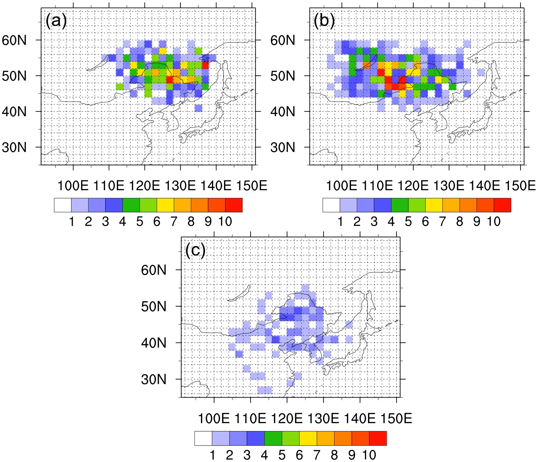
Fig.2.Spatial distributions of the occurrence days for three types of NCCV activities in late summer, (a) Clus-1, (b)Clus-2, and (c) Clus-3 (units: d).
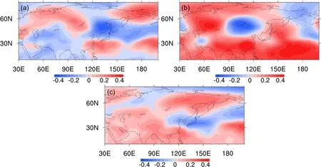
Fig.3.Spatial distributions of the correlations between the indexes of three types of NCCV and the 500-hPa geopotential height field in late summer, (a) Clus-1, (b) Clus-2, and (c) Clus-3 (correlation coefficients in doted areas have passed the significance test at the 90% confidence level).
5.Relationships of the NCCV in late summer with the SST and SIC in the preceding period
Figure 4 shows the spatial distributions for the correlations of the Clus-1 index with the SSTs in late summer and the preceding period, respectively.It can be seen that there are persistent correlations between the Indian Ocean SST and the Clus-1 index from March through late summer,where the signals appear the strongest in April before gradually weakening.Specifically, significant negative correlations appear over the southeastern Indian Ocean, while significant positive correlations are found over the Arabian Sea and the areas to its south.Statistically, the persistent correlations of this distribution pattern reflect the continuous influence of the SST anomaly of the North Indian Ocean dipole (NIOD)in the preceding spring on Clus-1; that is, the positive (negative) phase of NIOD in April of the preceding period corresponds to stronger (weaker) Clus-1.Therefore, it can be preliminarily inferred that the anomalous NIOD in the preceding April is an SST factor related to the anomalous Clus-1 in its intensity.
Figure 5 shows the spatial distributions for the correlations of the Clus-2 index with the SSTs from April to the late summer, respectively.It can be seen that the correlations exhibit a dipole pattern in the north-south direction over the Indian Ocean in the preceding period and are at their strongest in June.Specifically, significant negative correlations appear over the equatorial Indian Ocean, and significant positive correlations appear south to 30°S.Statistically, this correlation distribution pattern reflects the influence of the SST anomaly of the South Indian Ocean dipole (SIOD) inthe early summer on Clus-2, that is, the positive (negative)phase of SIOD in the preceding June corresponds to a stronger (weaker) Clus-2.

Fig.4.Correlation coefficients of the Clus-1 indexes with the SSTs in (a) March, (b) April, (c) May, (d) June, and (e)late summer (the doted areas have passed the significance test at the 90% confidence level).The regions shown in red boxes from left to right are NIOD, EP1, and NAT in (b).
To verify whether the key circulation patterns of the NCCV in late summer are related to the SST anomaly in the Indian Ocean during the preceding period through the airsea interaction, the NIOD index (NIOD-I) in April and the SIOD index (SIOD-I) in June of the preceding period are defined, respectively.The results of the 500-hPa geopotential height field regressed onto the NIOD-I in April and SIOD-I in June are shown in Figs.6a and 6b.It can be seen that the regression of 500-hPa geopotential height onto the NIOD-I shows significant positive anomalies over Lake Baikal and eastern Siberia and significant negative anomalies to the east of NEC.It also presents an EAP teleconnection wave train along the coasts of East Asia.This distribution pattern is basically consistent with the distribution of the significant correlations between the Clus-1 index and the 500-hPa geopotential height in late summer.It can be preliminarily inferred that the EAP pattern along the coasts of East Asia is related to the NIOD SST anomaly in the preceding April through the air-sea interactions, thus causing the Clus-1 intensity anomaly.
Compared with the traditional definition of the IOD(Saji et al., 1999), the positive anomaly area of the west pole, in the definition of the NIOD in this paper, is larger and farther north, while the negative anomaly area of the east pole is farther south.Positive anomalies appear over most of the tropical Indian Ocean and the areas to its north.Previous studies have shown that the SST anomaly in the tropical Indian Ocean is often associated with anomalous anticyclones over the Northwest Pacific and the climate anomalies in East Asia (Chowdary et al., 2011; Wang et al., 2013a, b;Yang et al., 2015b).Since the end of the 1980s, the Hadley and Ferrell cells over the Northern Hemisphere, related to the SST anomaly in the tropical Indian Ocean, have been significantly enhanced, with their activity scopes extending further northwards to middle latitudes.Therefore, the influence of the Hadley and Ferrell cells on the atmospheric circulations over the middle latitudes of Eurasia increases (Han et al.,2018).Zhao et al.(2019) found that the positive SST anomalies of the Indian Ocean in the preceding March and Aprilcan affect the western Pacific subtropical high and the precipitation over the NEC by adjusting the atmospheric circulations (such as the vertical motions and Hadley cell).It is also indicated that the SST anomaly in the tropical Indian Ocean has an important forcing effect on the anticyclone in the Western Pacific.The warmer Indian Ocean SST can stimulate a Kelvin wave propagating into the Northwest Pacific,which leads to an anomalous anticyclone near the Philippine Sea and excites the Pacific-Japan (PJ) teleconnection type along the coast of East Asia (Xie et al., 2009; Wu et al.,2010).Based on the conclusions in previous studies, it can be inferred that the NIOD anomaly could adjust the EAP pattern through the eastward-moving Kelvin wave, which further affects the Clus-1 intensity.
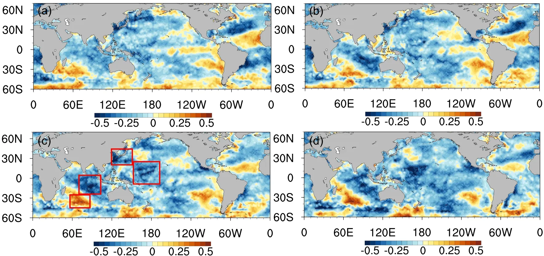
Fig.5.Correlation coefficients of the indexes of Clus-2 with the SSTs in (a) April, (b) May, (c) June, and (d) late summer (the dotted areas have passed the significance test at the 90% confidence level).The regions shown in red boxes from left to right are SIOD, NWP, and EP2 in (c).

Fig.6.The 500-hPa height field in late summer regressed onto the (a) NIOD-I in the preceding April and (b) SIOD-I in the preceding June.Dotted areas indicate where the regression values have passed the significance test at the 90%confidence level.
Figure 6b shows that the regression of 500-hPa geopotential height onto the SIOD-I exhibits a wave train of a “+ - +”pattern from west to east over the middle and high latitudes of Eurasia.Significant negative anomalies appear over Lake Baikal, and significant positive anomalies appear over the Okhotsk Sea.Nevertheless, the positive anomalies near the Ural Mountains fail the 10% significance test.This distribution pattern is similar to the “Ural-Baikal-Okhotsk” coordination pattern between the Clus-2 intensity index and the 500-hPa geopotential height field in late summer.It can be preliminarily inferred that the “Ural-Baikal-Okhotsk” coordination pattern in late summer is related to the anomalous SIOD SST in the preceding June, which further enhances the anomalous Clus-2 intensity.Previous studies have suggested that the SIOD is closely related to regional air-sea interaction.Not only can it change the distribution of heat flux in the atmosphere over South Asia and the tropical Pacific, but it can also affect the extratropical atmospheric circulation(Behera and Yamagata, 2001).Suzuki et al.(2004) and Yang et al.(2007) pointed out that the changes in the SST of the extratropical southern Indian Ocean in the preceding spring have an important impact on the summer atmospheric circulation and precipitation in NEC.The meridional circulation anomaly caused by the SIOD mode will strengthen the subtropical high in the Northeast Pacific, which is conducive to the maintenance of the anomalous anticyclonic circulation in the South China Sea and the Philippines.This teleconnection is also one of the ways in which SIOD affects the precipitation in eastern China (Xu et al., 2013).The correlation coefficient between the SIOD-I and the SIOD indexes, as defined by Yang and Ding (2007), reaches as high as 0.93.Therefore, it is suggested that the 500-hPa circulation field over East Asia is affected by the SIOD in the preceding June by affecting the meridional circulation and the western Pacific subtropical high, which further causes the intensity anomaly of Clus-2.
It should be noted that, except for the Indian Ocean, the SSTs of equatorial Pacific (EP) and NAT in the preceding April are also significantly correlated with Clus-1, and the SSTs of Northwest Pacific (NWP) and the EP in the preceding June are significantly negatively correlated with Clus-2.To determine the SST factors affecting the NCCV, the partial correlation coefficients between the two types of NCCV indexes and the SST index of each region in the preceding months of April and June and the contribution rates of SST indexes to the NCCV indexes were calculated (Table 3).For each type of NCCV, a partial correlation indicates the correlation between the NCCV and the SST, excluding the influence of the other two SST key areas.For example, the partial correlation between the NIOD-I and NCCV index for clus-1 indicates the correlation excluding the influence of the EP and NAT.It can be seen that the partial correlation coefficients of the NIOD-I in the preceding April and the SIOD-I in the preceding June with the NCCV intensity index are 0.44 and 0.40, respectively, which have passed the significance test at the 90% confidence level, while the partial correlation coefficients between other SST indexes and NCCV intensity indexes fail the 10% significance test.At the same time, the contribution rates of NIOD-I and SIOD-I to the NCCV intensity index are 29.5% and 31.2%, respectively,which are higher than those of other SST indexes.Therefore,the NIOD-I and SIOD-I are selected as the major factors in the preceding period that contribute to the first two types of the NCCV.

Table 3.The partial correlation coefficients between NCCV indexes for Clus-1 (Clus-2) and SST indexes, excluding the influence of the other two SST indexes for Clus-1 (Clus-2), and the variance ratios between NCCV indexes and SST indexes.
Figure 7 shows the sliding correlation coefficients between each SST index and the NCCV intensity index.It can be seen that the sliding correlation coefficients of the NIOD-I in the preceding April and the SIOD-I in the preceding June with the NCCV intensity index have passed the significance test at the 90% confidence level during the entire period, while the coefficients between other SST indexes and the NCCV intensity index are relatively small; further proving that the Indian Ocean SST in the preceding period is the key factor affecting the anomalous NCCV in late summer.
It is known that the Arctic SIC plays an important rolein regulating the climate change due to its high albedo and its tendency to block the exchanges of heat, water, and momentum between the atmosphere and the ocean (Honda et al., 1999; Rigor et al., 2002; Alexander et al., 2004; Wu et al., 2004).Changes in the SIC will induce changes in various factors, such as surface heat flux, near-surface temperature, and sea level pressure (Alexander et al., 2004).Previous studies show that the Arctic SIC provides a complementary precursor for Chinese summer rainfall variability (Wu et al.,2009).Wu et al.(2013) found that the winter-spring SIC and North Atlantic SST anomalies can cause atmospheric circulation anomalies over northern Eurasia in summer by affecting the atmospheric circulation over southern Newfoundland in spring.He et al.(2018) also indicated that the June SIC variability in the Barents Sea exerts the most significant impact on the East Asian rainfall pattern in August.As an active climatic factor in middle and high latitudes in late summer, a question arises; is the NCCV also affected by the SIC in the preceding period? To resolve this, the correlation coefficients of Clus-1 and Clus-2 with the Arctic SIC in the preceding period are calculated (Fig.8).It is found that the Clus-1 index is well correlated with the SIC in the preceding June, where there are significant positive correlations in the NB north of the Severnaya Zemlya.The Clus-2 index has a robust correlation with the SIC in the preceding April,where there are significant positive correlations in the Barents Sea, the Kara Sea, and the regions to their north.The results indicate that the NCCV anomaly in late summer may be affected by the Arctic SIC anomaly in the preceding period.
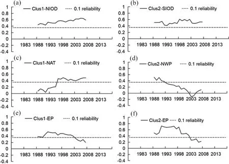
Fig.7.Panels (a, c, e) show the 21-year sliding correlation coefficients between the Clus-1 index and SST indexes in the preceding April, and panels (b, d, f) show the 21-year sliding correlation coefficients between the Clus-2 index and SST indexes in the preceding June.
Regression analysis was carried out to verify whether the Arctic SIC anomaly in the preceding period caused the anomalous circulation pattern corresponding to the NCCV in late summer.Figures 9a and 9b show the results of the NB index (NB-I) in the preceding June and the BS index(BS-I) in the preceding April, regressed against the 500-hPa geopotential height in late summer, respectively.It can be seen that the regression field of NB-I presents a significant positive anomaly appearing over Lake Baikal, which is consistent with the key circulation pattern during the same period corresponding to Clus-1 (Fig.3a).However, the meridional wave along East Asia is not as significant as that from Fig.3a, indicating that the anomalous SICs in the NB in the preceding June may affect the Clus-1 intensity by means of the Lake Baikal high pressure through a wave train in midhigh latitudes.The regression field of BS-I presents significantly positive anomalies over the Ural Mountains and to the south of the Okhotsk Sea, while the negative anomalies over Lake Baikal are not significant.This circulation pattern is basically consistent with the key circulation pattern during the same period corresponding to Clus-2 (Fig.3b), indicating that the anomalously greater SICs in the preceding April in the Barents Sea are favorable for the formation of “Ural-Baikal-Okhotsk” coordination pattern in late summer,which further affects the Clus-2 intensity.The increase in SIC will result in a decrease in the heat flux between the ocean and the atmosphere, a decrease in the SST, and an increase in the SLP (Alexander et al., 2004).The integrated effects of persistent SIC anomalies from spring to early summer may affect the sub-polar westerlies in summer by changing the albedo and heat flux between the atmosphere and the ocean, thus, further affecting the re-distribution of Rossby waves in Eurasia (Wu et al., 2009).So the anomalously greater SICs in the NB may cause the anomalous Lake Baikal high pressure on its south side along the same longitude.Moreover, the anomalously greater SICs in the BS may cause the anomaly of the Ural high pressure on its south side.The anomalously greater SICs from the spring to early summer are favorable for forming the anomalous high pressure to the south.This pattern could induce the anomalous atmospheric circulations downstream, in middle and high latitudes of East Asia, by affecting the Rossby wave train in the westerlies, further leading to anomalous NCCV intensities.
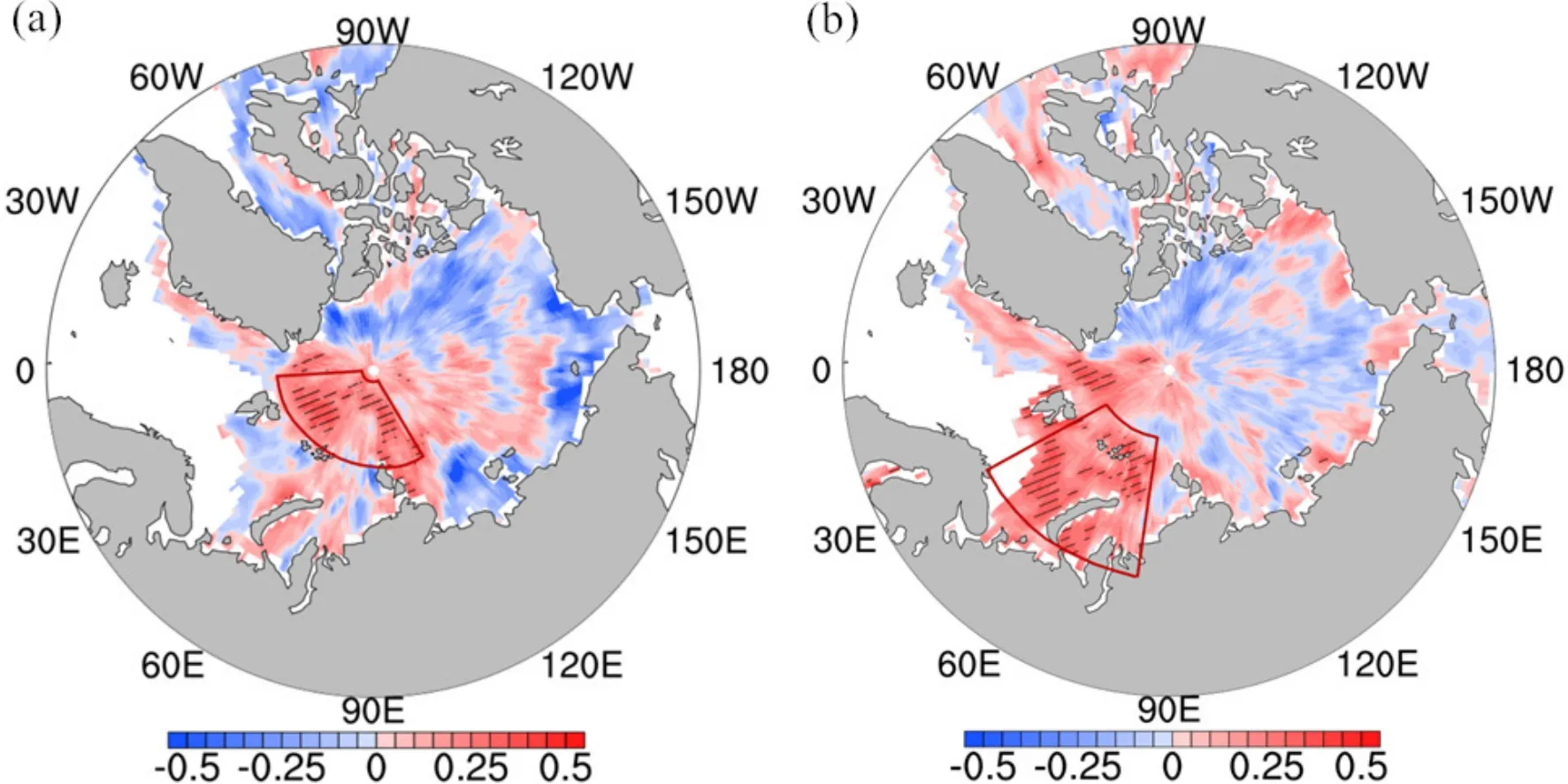
Fig.8.(a) The correlations between the Clus-1 index and the SIC in the preceding June and (b) correlations between the Clus-2 index and the SIC in the preceding April.The region in (a) is the Nansen Basin and (b) is the Barents Sea.The lined areas indicate where the correlations have passed the significance test at 90% confidence level.

Fig.9.The 500-hPa geopotential height fields in late summer regressed onto the (a) NB-1 and (b) BS-1 series.Dotted areas indicate where the regressions have passed the significance test at the 90% confidence level.
Figure 10 shows the time series of NCCV indexes for Clus-1 and Clus-2, as well as the corresponding SST and SIC indexes.The NCCV index for Clus-1 shows a consistent interannual variation with NIOD-I and NB-I, featuring correlation coefficients above 0.4, all significant at the 90% confidence level.The NCCV index for Clus-2 is consistent with SIOD-I and BS-I, with correlation coefficients above 0.5, significant at the 90% confidence level.The seven years with high NCCV index values above 0.5 for Clus-1 (1981, 1986,1995, 2003, 2007, 2010, 2017) all corresponded with positive anomalies of NIOD-I and NB-I, except for 1995.For Clus-2,the eight years with high index values above 0.8 (1979,1981, 1982, 1987, 1988, 1993, 2000, and 2010) all corresponded with positive anomalies of SIOD-I and BS-I,except for 1988 and 2000.At the same time, only two years(1979, 1990) fail to correspond with the negative anomalies of both NIOD-I and NB-I among the fourteen years (1979,1983, 1984, 1988, 1989, 1990, 1992, 1997, 2008, 2011,2012, 2014, 2015, 2018) with low values below -0.75 for Clus-1.The nine years with low NCCV index values below-0.8 for Clus-2 (1991, 1995, 1996, 2001, 2002, 2005, 2007,2009, 2016) all correspond with the negative anomalies ofSIOD-I and BS-I, except for 2001 and 2005.The results suggest a combined effect of SST and SIC on the NCCV in midsummer.
6.Sensitivity tests of the numerical model
The above observational analyses have revealed the possible effects of the Indian Ocean SST and Arctic SIC in forcing late summer air circulation.In this section, the results obtained by the statistical methods in section 5 will be verified based on the sensitivity tests of CAM5.3.The experimental design has been introduced in detail in section 2.2.4.
Figure 11 shows the composite analysis of the numerical model results.The analysis uses the July-August average of the 500 hPa geopotential height, averaged over the assessment period (years 6 to 15), which is then differenced, asdescribed in the caption.Numerical simulations reveal that the model results separately forced by the Indian Ocean SST or the Arctic SIC are quite different from the observations in Fig.3 (Figs.11a-d), while the overall distribution pattern in model results jointly forced by the SST and SIC anomalies is similar to the observations (Figs.11e-f).In Fig.10, the regional anomaly forcing for Fig.11e is that for Fig.11a, plus that for Fig.11c, which is similar to Fig.11f.In the model results (Fig.11e) jointly forced by the NIOD SST in the preceding April and the NB SIC in the preceding June, there are meridional anomalies from north to south along the coasts of East Asia.Specifically, negative geopotential height anomalies appear over the Okhotsk Sea, accompanied by positive anomalies to its south.This circulation pattern is similar to the EAP pattern in Fig.3a, except that the high pressure in the Russian Far East is not well simulated.In addition, the positive correlation over Lake Baikal in Fig.3a is also revealed in the model results.Figures 11a and 11c show a poor performance compared with Fig.11e, as Fig.11a fails to present the positive anomaly over Lake Baikal.In model results jointly forced by the SIOD SST in the preceding June and the BS SIC in the preceding April(Fig.11f), positive anomalies appear over the area near the Ural Mountains and east to the Okhotsk Sea.Negative anomalies appear from Lake Baikal to NEC, which is basically consistent with the “Ural-Baikal-Okhotsk” pattern in Fig.3b.Figures 11b and 11d show a poor simulated result from Lake Baikal to NEC.Thus, the numerical simulation results in Figs.11e-f reproduce the observations well, which indicates that the combined effects of SST and SIC in the preceding period can create substantial atmospheric anomalies persisting into late summer and cause anomalous circulations for the first two types of the NCCV in late summer.

Fig.10.Standardized anomaly time series of the NCCV indexes (black) for (a) Clus-1 and (b) Clus-2.The NIOD and SIOD indexes are in gray, and the NS and BS indexes are in yellow during 1979-2018.
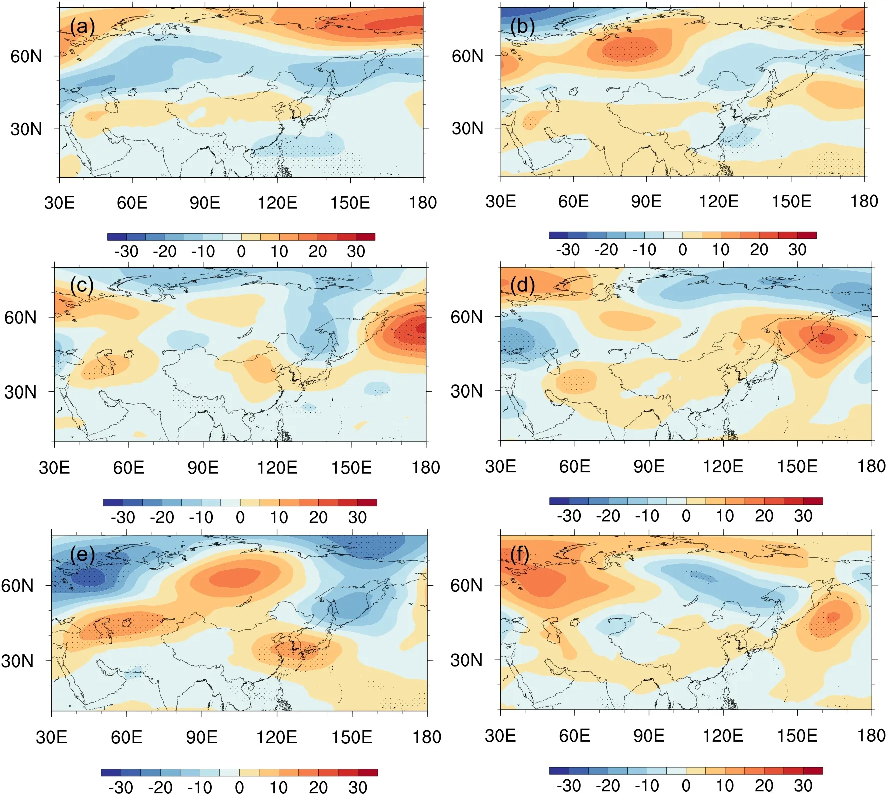
Fig.11.Composite analysis for the simulated 500-hPa geopotential height field in late summer.The difference between (a) SST1 and SSTc, (b) SST2 and SSTc, the difference between (c) SICMax1 and SICMin1, (d) SICMax2 and SICMin2, the difference between (e) SSTSIC1 and SICMin1, (f) SSTSIC2 and SICMin2.Dotted areas indicate where the values have passed the significance test at the 90% confidence level.
Notably, the observed results of separated SST and SIC are basically linear relationships, while the numerical results suggest a highly nonlinear interaction.We selected years with positive values above 0.6 and negative values below 0.6 for both the SST and SIC indexes (Table 4).We then calculated the difference between the high-value and low-value years using the July-August averaged 500 hPa geopotential height.The composite results are shown in Fig.12 and present an EAP-like distribution in East Asia with positive anomalies over Lake Baikal for Clus-1 and a “Ural-Baikal-Okhotsk” pattern in the mid-high latitudes for Clus-2, which suggests that the model results are consistent with the statistical analysis results, that is, the mechanisms for the influence of the SST and SIC on atmospheric circulations of NCCV are nonlinear and complicated.

Table 4.The years with positive values above 0.6 and negative values below 0.6 for both the SST and SIC indexes for Clus-1 and Clus-2.
7.Conclusions and discussion
The NCCV processes identified in late summer are classified into three types according to their trajectories based on an objective identification method.In particular, for the first two types of the NCCV, the impact factors of atmospheric circulations during the same period and the influencing factors of SST and SIC during the preceding period are emphatically discussed in this study.
(1) The NCCV processes in late summer can be objectively classified into three types in terms of the trajectories.The first type is the NCCV, with a short-distance southeastward trajectory, which is mainly generated near the Stanovoy Range in eastern Russia and dissipates in the northeast part of NEC after a short distance of southward or southeastward movement, with a large-value area of occurrence days located in the north part of NEC.The second type is the NCCV, with a long-distance eastward trajectory.The cold vortex is generated near Lake Baikal and moves eastwardto large areas of NEC, with a large number of occurrence days concentrated in Mongolia and the northwest part of NEC.The second type has the greatest impact on the NEC and thus is the most noteworthy among the three types.The NCCV with a short-distance eastward trajectory is not a typical type that affects the NEC.

Fig.12.Composite analysis for the observed 500-hPa geopotential height field in late summer.The difference between high-value yeas and low-value years for (a) Clus-1 and (b) Clus-2.Dotted areas indicate where the values have passed the significance test at the 90% confidence level.
(2) The statistical analysis shows that the EAP along the coast of East Asia and the high pressure over Lake Baikal, a key circulation pattern causing the intensity anomaly of Clus-1, is forced by both the SST anomaly of NIOD in the preceding April and the SIC anomaly of NB in the preceding June.The “Ural-Baikal-Okhotsk” coordination pattern in late summer is forced by the SST anomaly of SIOD in the preceding June and the SIC anomaly of BS in the preceding April, causing the intensity anomaly of Clus-2.The Indian Ocean SST may impact the NCCV intensity by affecting the intensity of the western Pacific subtropical high and adjusting the atmospheric circulations over East Asia.The anomalously greater SICs in the preceding period may be related to the anomalously strong high pressure south of the Arctic sea ice, which leads to the anomalous atmospheric circulations in middle and high latitudes of East Asia, further reinforcing the intensity anomaly of the NCCV.
(3) Sensitivity tests show that the model-simulated late summer circulations separately forced by the Indian Ocean SST or Arctic SIC are inconsistent with the observations.In contrast, model results jointly forced by the two factors of SST and SIC can well reproduce the observations, indicating that the late summer NCCVs are influenced by the combined effects of the SST and SIC in the preceding period.The model results are consistent with the statistical analysis results; that is, the mechanisms for the influence of the SST and SIC on atmospheric circulations of NCCV are nonlinear.
The results suggest a coordinated influence of early SST and SIC on the different paths of NCCVs in late summer, which provides a certain guiding significance for the fine prediction of NCCV and long-range climate forecasting in North China.It should be noted that the mechanisms that influence the SST and SIC on atmospheric circulations of NCCV are nonlinear and complicated.Based on the existing research, the possible influencing mechanisms are preliminarily investigated in this study, while the specific physical mechanisms of persistence of the SST or SIC anomalies (in fact,the anomalies in the early stage can last until summer but weaken with the intensity) and their interactions with the atmosphere need to be further explored.In addition, the atmospheric circulations of Clus-1 and Clus-2 in this study are similar to the fourth and third types in early summer in Fang et al.(2021), respectively.And whether there is a connection between them needs to be further explored.
Acknowledgements.This work was jointly supported by the National Natural Science Foundation of China (Grant No.42005037); Special Project of Innovative Development, CMA(CXFZ2021J022, CXFZ2022J008, and CXFZ2021J028); Liaoning Provincial Natural Science Foundation Project (Ph.D.Start-up Research Fund 2019-BS214); and Research Project of the Institute of Atmospheric Environment, CMA (2021SYIAEKFMS08,2020SYIAE08 and 2021SYIAEKFMS09).
杂志排行
Advances in Atmospheric Sciences的其它文章
- Detection of Anthropogenic CO2 Emission Signatures with TanSat CO2 and with Copernicus Sentinel-5 Precursor (S5P) NO2 Measurements: First Results
- Will the Historic Southeasterly Wind over the Equatorial Pacific in March 2022 Trigger a Third-year La Niña Event?
- Unprecedented Heatwave in Western North America during Late June of 2021: Roles of Atmospheric Circulation and Global Warming
- Evolution of Meteorological Conditions during a Heavy Air Pollution Event under the Influence of Shallow Foehn in Urumqi, China
- Assimilation of Ocean Surface Wind Data by the HY-2B Satellite in GRAPES: Impacts on Analyses and Forecasts
- Kinetic Energy Budgets during the Rapid Intensification of Typhoon Rammasun (2014)
