Magnetic fabric and geomorphic characteristic of Neotectonic activity along strike direction of North Almora Thrust, Kumaun Lesser Himalaya, India
2022-05-18RituChuhnGirishChKothyriSurenrBhkuniPitmerDuttPntAjyKumrTloor
Ritu Chuhn , Girish Ch Kothyri , Surenr S. Bhkuni , Pitmer Dutt Pnt ,Ajy Kumr Tloor
a CAS in Geology, Kumaun University, Nainital, India
b Institute of Seismological Research, Raisan, Gandhinagar, 382009, India
c Wadia Institute of Himalayan Geology, Dehradun, India
d Department of Remote Sensing and GIS, University of Jammu, Jammu, India
ABSTRACT Structurally, the North Almora Thrust (NAT), is placed in the northern proximity of the Almora Nappe(AN) in the Kumaun Lesser Himalaya. The NAT is characterized by the presence of a zone of mylonitic rocks of basal Saryu Formation(1800±100 Ma)in the hanging wall and the metasedimentaries of Inner Lesser Himalayan rocks as the footwall block.The NAT has been dextrally offset by two estabilished major faults i.e. Saryu River Fault (SRF) in Saryu Valley and Dwarahat-Chaukhutia Fault (DCF) in Ramganga valley. In present study, we identified four new faults, based on field study, geomorphic landform and magnetic fabric analysis. These faults are N-S trending Pancheshwar Fault, NE-SW Rameshwer Fault,NNE-SSW trending Kosi Fault,and NNE-SSW trending Gagas Fault(GF).Our results show that the zone is bound by cross cutting relation with NAT and these fault zones are comparatively more active than other regions.Furthermore,we suggest that the steep and NW-SE orientation of magnetic foliation within the NAT zone is a result of NE-SW oriented progressive regional compression. The magnetic foliations represent the unseen internal foliations in the rocks developed due to preferred alignment of magnetic minerals and can be found through the Anisotropy of magnetic susceptibility (AMS) study. Variation in the alignment of the field and magnetic foliations are developed due to superimposed brittle deformation along the faults over the pre-existing field foliations.Magnetic foliations represent the impact of last stage deformation and significant to find brittle deformation and finite strain in the rocks of the study area. The lowering of anisotropy (Pj) away from the fault zone represents distribution of strain across the NAT zone.AMS fabric confirms the presence of faults developed across the NAT zone and also explains the deformation pattern along these faults. The geomorphic anomalies and steepness changes across the NAT zone are correlated with active deformation along the NAT and associated transverse faults.© 2022 Editorial office of Geodesy and Geodynamics. Publishing services by Elsevier B.V. on behalf of KeAi Communications Co. Ltd. This is an open access article under the CC BY-NC-ND license (http://creativecommons.org/licenses/by-nc-nd/4.0/).
Keywords:North Almora Thrust (NAT)Geomorphology Anisotropy of magnetic susceptibility Neotectonics Kumaun Lesser Himalaya
1. Introduction
The foreland propagated advancing thrusts in the Himalayan region resulted from the intra-continental convergence between Indian and Eurasian plates that began ~55 Ma ago[1,2].From north to south, these thrusts are the Main Central Thrust (MCT), Main Boundary Thrust (MBT) [3] and Himalayan Frontal Thrust (HFT),where MCT places the high grade Higher Himalayan crystalline rocks over the low grade Lesser Himalayan rocks, and MBT places these Lesser Himalayan rocks over the Sub-Himalayan rocks,known as Siwaliks [4-7]. The complex geological setting of the Higher Himalaya is associated with duplex structures of the thrust system [8]. In the Lesser Himalayan crystalline zone, the neotectonic deformation occurs along the splays of MCT and MBT[2,9-12],where tectonic deformation is assumed to be high due to formation of out-of-sequence thrusting [3,13-15]. The MBT, MCT and associated thrust imbrications and transverse faults show evidence of neotectonics. Their reactivation is marked by dip-slip,oblique-slip and strike-slip movements which have developed the Late Quaternary geomorphic features [10,16-18].
Early studies claimed that the frontal part of the Himalaya is also neotectonically active caused by presence of transverse faults, e.g.the Paonta Fault in NW Himalaya[19].The high seismicity along the Aravalli horst and Muradabad fault [20], along Sonipat, Sohna and Muradabad faults i.e. Dharchula seismic belt and along transverse Hardwar-Delhi ridge[21],explains the tectonically active nature of transverse faults.In Kumaun Himalaya,the epicenters trend found in transverse linear pattern[12,22-25]which is suggestive of tear movement. In the Kumaun Lesser Himalaya, early neotectonic studies proved that the transverse faults i.e. (Fig.1) (Chaukhutiya,Raintoli and Binau- Ramganga-Naurar transverse structure) are neotectonically active [10,18,20,26-28].
Globally studies suggest that the deformations within the thrust/fault zones significantly affect the rock magnetic field, and can be analyzed using the Anisotropy of Magnetic Susceptibility(AMS) [28-38]. Detailed AMS with structural and geomorphic studies carried out earlier claimed the active nature of Chaukhutiya transverse fault in the Kumaun Himalaya at NAT zone [28]. Since NAT zone is affected by later developed transverse faults all along its continuity,the structural setting and deformation pattern at the intersection of these transverse faults and NAT need to be understood,which may have been responsible for active deformation in the Himalayan region. Based on geomorphic anomalies, the tectonic uplift and abnormal increase of river gradient in the Himalayan domain is caused by the differential motion along the major thrusts/faults[39-45].The knick points give relative idea about the rate of uplift and changes along the river gradients concerning the reference points and reconstruction of the river system during the Late Quaternary and Holocene. Furthermore, structural change in lithological units owing to brittle deformation is examined through the AMS[28].AMS study is well used in plastically deformed rocks,but few studies have been done in fractured and faulted rocks[34,35]. The method precisely delineates the induced changes caused by brittle and ductile deformation.Therefore, in this study,we applied both AMS,and geomorphic field techniques to identify a wide range of deformation along the thrusts and fault in Kumaun Lesser Himalayan domain and Kali, Saryu, Panar, Jaigan, Sim, Kosi and Gagas valleys are investigated in detail.
2. Geology of the area
The present area of investigation forms a part of the synclinally folded Almora Nappe(AN)in the Kumaun Lesser Himalaya.The AN represents a large thrust sheet, having low-to medium-grade metamorphic rocks flanked by North Almora Thrust (NAT) in the north and by South Almora Thrust(SAT)in the south[5,18,46].The NAT zone mainly comprises quartz-porphyry,chlorite schist,biotite schist followed by garnetiferous mica schist interbedded with flaggy grey-white sericite quartzite of the Saryu Formation(Almora Group),and slates,phyllite and quartzites of the Rautgara,quartzite with penecontamporaneous basic volcanics of the Berinag and limestone of Deoban formations [4,5,47]. The rocks along the NAT zone are highly mylonitized and classified into ultramylonite,mylonite and protomylonite rocks based on the relative abundance of relict clasts.
3. Quaternary landform development

Fig.1. Location map of the study area shows surface trace of North Almora Thrust (NAT) and associated transverse faults.

Fig. 2. Longitudinal profiles of Saryu, Jaigan, Kosi, Ramganga and Gagas rivers flowing across the NAT zone.
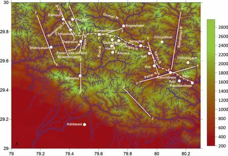
Fig. 3. Drainage anomaly map of the study area. The transverse faults are marked by white broken line.
The Geomorphic systems withinside the NAT zone west of Kali valley to Gagas valley were analyzed to apprehend Quaternary and active deformation withinside the NAT zone,in which slope breaks or unexpected drop of the river channels are geomorphologically expressed with the aid of using presence of knick-points (Figs. 2 and 3). Studies shows that the anomalous modifications in gradient and steepness alongside the longitudinal river are due to the neotectonics movements alongside the faults/thrusts and are indicated with the aid of using excessive Gradient Index(GI)value[9-12,18,46]. The steep slope alongside knick points may be in all likelihood due to motion alongside faults/thrust passing via the vicinity.The classic geomorphical features alongside the NAT zone and its transverse faults including fault scarps, active landslides zones, vertical uplift of terraces, formation of landslide-induced lakes, entrenching nature of the river, tilting of terraces,triangular cones and facets, straight course of the river shifting of the river and the gorge nature of streams imply that the vicinity is tectonically active[15,17,18]. Within the NAT zone, the Kali river takes a ENE-WSW swing among Haldu and Pancheshwar and grows to be N-S towards the downstream (Fig.1) in which three levels inclined strath terraces are nicely preserved[9].Additionally,dip parallel slicken sides are nicely preserved withinside the NAT zone(Fig.4a).Furthermore,the lithological units are highly sheared and crushed due to later brittle deformation withinside the NAT zone, such highly deformed rocky slopes are favorable for mass movement withinside the vicinity of the N-S Pancheshwar fault(PF)(Fig.4b).The NE flowing Panar River flows parallel to the hint of NE-SW orientated Rameshwer fault(RF)and merged with Saryu river close to Rameshwar (Fig.1). Within the fault zone, the river grews to be incised and shaped a narrow V shaped valley.On both sides of the valley, numerous old and new active landslides are present (Fig. 5a and b). Apart from the latest landslide deposits,there are numerous big old landslide deposits in the area.Between Seraghat and Seri, the Saryu River flows parallel to the NNW-SSE orientated Saryu River Fault (SRF) [9,15,18,26] were several geomorphic features of active deformation are developed. These features are uplifted terraces, straight course of river, triangular fault sides and alluvial cones, tilting (10) of terraces, incision of bedrock, waterfalls withinside the terminal vicinity are representatives of the NNW-SSE trending Fault [9,15,17,26,27]. In addition to this presence of lacustrine mud deposit shows damming of the river valley, and lateral migration of the river for the duration of Holocene shows active deformation of SRF [9].Similarly,the NW-SE flowing Kosi River abruptly modifications the direction and flows NNE-SSW close to the Ranman vicinity parallel to the NNE-SSW orientated Kosi fault (KF) [47,48]. Two to three levels of uplifted terraces are reported from the vicinity in which valley fill deposits are rest over highly sheared and faulted bedrock of the Saryu Formation. Thick deposit of old landslide deposit and tilted fluvial reflect that the zone is tectonically active (Fig. 6a and b). Similarly, the Gagas River flows parallel to the NNE-SSW orientated Gagas fault (GF) among Binta and Bagwalipokhar. Near Binta strike parallel slickenside withinside the rocks of Saryu Formation are nicely preserved. Presence of a prominent offset of lower order of streams parallel to the fault shows the strike-slip nature of the GF [10,26,49]. Moreover, a few different geomorphic features, including wide straight valley, triangular cone and facets withinside the upthrown block, the presence of fossil valley and related gorges and huge mud deposit withinside the segments of the fault show the active nature of the GF [7,10,50].
4. Anisotropy of Magnetic Susceptibility (Ams) study

Fig. 4. Field photographs shows (a) Inclined slickensides on quartz-mica schist and (b) landslide before Laddang.

Fig. 5. (a) and (b) field photographs shows landslides along Panar Valley.
The study is an extension of our previous work in NAT zone[18,26,28,46]. Earlier workers have used the AMS technique successfully to understand the late-stage deformation and tectonic nature of the Himalaya region [28,51-54]. AMS is a method for investigation of the finite magnetic strain and , magnetic foliation pattern in plastically deformed rocks [29,32,38,51,55-58]. AMS analysis has been carried out on cores of oriented rock samples collected from the NAT zone. The cores were analyzed in 15 different directions with reference to the north using a KLY-3 Kappabridge (AGICO, Czech Republic) instrument [59,60]. AMS study represents geometry, shape and magnitude of magnetic strain ellipsoids by three magnetic principal axes (K1≥K2≥K3).There are two elements, associated with these principal magnetic axes viz. Magnetic foliation ‘F’ (K1- K2 Plane) and magnetic lineation ‘L’ (K1) and their anisotropy parameters are described by eccentricity ‘Pj’ and its shape ‘T’ [38,65].
It is well established[47,58,61-63] that phyllosilicates (paramagnetic minerals) are dominating minerals in the rocks, and playing important role in developing anisotropy (in Magnetic susceptibility) in the taconites.

Fig. 6. (a) debris of old landslide and (b) Tilted fluvial terrace reflect the tectonically active zone near Someshwer.
5. Data analysis and interpretation
5.1. Mineral magnetics and magnetic susceptibility
Magnetic mineral study is very important prior to AMS study to understand the AMS data and for its interpretation in significant manner. Since ferromagnetic and paramagnetic minerals contribute to the total AMS data, in order to understand the existence of magnetic minerals better, we have carried out detailed petrographic and thermomagnetic studies in the samples.
10 representative samples of various rocks(Gh,D,S,DGh,D, P, SPand Din order of decreasing susceptibility) were examined.TSD-2 Schonstedt thermal demagnetizer was used to get the bulk magnetic susceptibility and temperature variation of these samples and Kappabridge [64] was used to determine the AMS, of the core samples with sensitivity of 2 × 10(SI) and accuracy of 0.1%.
The highly sheared and mylonitized granite gneiss in the vicinity of NAT contains fine to medium grained quartz,feldspar along with flaky minerals muscovite and biotite,arranged in the well-defined planer fabric. Apart from the major silicates, iron oxide like pyrrhotite as ferromagnetic constituents are also developed in microveins(Fig.7).Mica schist also forms an important lithology within the NAT zone and comprises quartz, biotite, muscovite, chlorite surrounding the porphyroblastic garnet. In comparison to the micaceous quartzite of Almora Group which portrays the welldeveloped schistosity, defined by substantial amount of fine to medium mica flakes and quartz, generally the quartz arenite of Rautgara Formation dominantly comprises quartz (diamagnetic minerals) with <10% paramagnetic minerals including mica in the study area. However, in the vicinity of NAT, the quartz arenite is highly sheared and its phyllosilicate contents control the behavior of magnetic susceptibility of the rock units (samples Gh, D, Sand J). The petrographic observation of the samples, collected from the fault zone reveals the presence of fine to very fine iron oxide (~6 μm) in micro-veinlets, intruded into the micro-quartzite and mica schist (Fig. 7).
The magnetic mineral studies have been done by means of petrography and stepwise thermal demagnetization method. The ten oriented representative samples were studied to obtain the thermal magnetic heating curves that define the discrete susceptibility and temperature determinations (up to 750C) that are directly related with magnetic carriers and are used to diagnose the magnetic minerals in the sample(Fig.8).Each rock unit in the NAT zone shows intense deformation and attendant recrystallization.A simple thermal heating of rock sample may result in not only magnetic phase transformation but it can also change the magnetic mineral grain size. The rock samples are treated under different successful applied heats, in which the rocks are not modified, and the measurement gives accurate data to determine the magnetic carriers. The petrographic observations and TSD-2 Schonstedt thermal demagnetization analysis reveals layered silicate is the key anisotropic component for the growth of tectonic rocks in NAT zone, and there are also a large number of records in other fault zones[47,58,61-63].The nucleation and development of iron oxide also has small but significant influence in the AMS data.
5.2. Anisotropy of magnetic susceptibility
The Pancheshwar sector is taken for the study,and it is the area surrounding the confluence zone of Saryu and Kali Rivers near Pancheshwar village. This sector is very important from the point of structural study through AMS since the area is affected by two cross-cut faults and one major NAT zone (Fig. 9a). Faults trending N-S are named as Pancheshwar Fault (PF) and ENE-WSW are subsidiary fault trending across the NAT zone as inferred by geomorphic data and strongly supported by the AMS fabric data of the area.
The magnetic study indicates that the magnetic foliation planes vary with the NAT trend and field foliation, while showing good relationship with the N-S and ENE-WSW oriented faults.They are giving magnetic foliation plane orientations N-S in Pspecimen and ENE-WSW in Pspecimen taken away and near the fault plane trace (ENE-WSW) respectively (Fig. 9a). Here N-S orientation of the magnetic foliation plane in Pspecimen represents the impact of the N-S oriented fault (Fig. 9a).
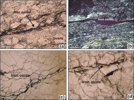
Fig. 7. Iron oxide veins along the fractures.

Fig. 8. Thermal dimagnetization plots of magnetic susceptibility of core samples of representative lithology of the study area.
Samples P, Pand Ptaken along the N-S oriented fault plane and across the NAT, show magnetic foliation in N-S direction, parallel to the N-S oriented fault plane (Fig. 9). Magnetic lineations are horizontal to sub-horizontal, gently plunging towards N (samples P, P, P) and W (sample P) (Fig. 9a). These magnetic lineations,however occupy the intersection of field and magnetic foliation plane at places(PP).The Pvs.Kplot of the granitic gneiss shows inverse relationship between the values of Pand K(Fig.9b).The AMS data plot of the lithology represents that all plots of micaceous quartzite,mica schist,mylonitic gneiss and granitic gneiss (Almora Group) are plotted in neutral to oblate field (T = 1 and T >0) (Fig. 9c) and represent flattening strain.
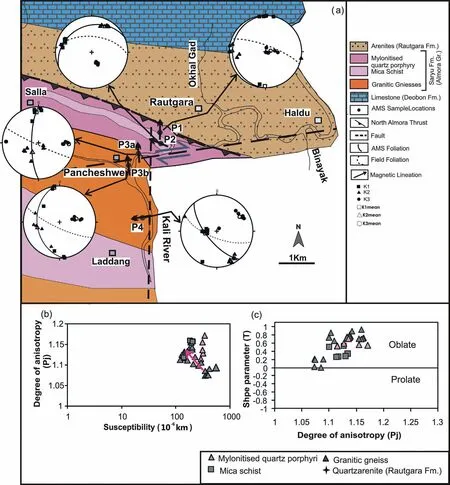
Fig.9. (a)Stereo projections of magnetic and field foliation(b)Pj vs.Km plot(c)T vs.Pj in the Kali valley in the NAT zone.Km=mean susceptibility,Pj=corrected magnetic anisotropy degree and T=shape parameter.
Along the NAT zone towards the NNW of Pancheshwer the area of Rameshwar is also affected by NE-SW trending Rameshwar Fault (RF) (Fig. 10a), NNE-SSW trending subsidiary fault and NAT zone.The magnetic foliation planes varyingly oriented WNW-ESEto NNW-SSE. Near NAT, the magnetic foliations are trending parallel to the NAT plane, whereas in the proximity of the faults their orientation swings from WNW- ESE through NW-SE to NNW-SSE making high angle with field foliation. At and around the intersection area of the fault planes, the strike of magnetic foliation planes are NW-SE and NNW-SSE,where minimum magnetic axes(K)on an average oriented towards NE and representing σof the conjugate set of the faults (Fig.10a). Pand Kplots are giving independent values of mylonite,schist and granitic gneiss(Fig.10b).Pvs. T plots show oblate shape dominating date of magnetic ellipsoids (Fig.10c).

Fig.10. (a) Stereo projections of magnetic and field foliation, (b) Pj vs. Km plot (c) T vs. Pj along Panar valley in the NAT zone. Km= mean susceptibility, Pj =corrected magnetic anisotropy degree and T=shape parameter.

Fig.11. (a)Stereo projections of magnetic and field foliation(b)Pj vs.Km plot(c)T vs.Pj along in the Saryu valley around Sartola,and(d)Km vs.Pj plot,and(e)T vs.Pj in Saryu valley from Naichan to Rantoli in the NAT Km= mean susceptibility, Pj =corrected magnetic anisotropy degree and T=shape parameter.
Along with the ongoing study along the NAT zone, a detailed work has been carried out in the Saryu valley. The area along the valley is controlled by NAT zone and NW-SE trending Saryu River Fault (SRF) running through Naichan-Rantoli area in the Saryu valley.Near Seraghat,the NAT swings from SW to SSE and coincides with NNW-SSE trending SRF (Fig. 1 and 11a). The AMS data between Naichan and Rantoli shows that the magnetic foliations are dominantly affected by NNW-SSE oriented SRF. Near the fault plane,the magnetic foliation are parallel to sub-parallel to the fault and oriented towards NNW-SSE to N-S. Here magnetic foliations are parallel-subparallel to field foliation due to parallel orientation of SRF and NAT zone and later effect of strike slip faulting in same direction.The rock sample(S)collected away from the fault plane gives WNW-SES trend (Fig. 11a). Magnetic foliation planes are steeply inclined with horizontal magnetic lineation except one specimen (S6) showing gently plunging lineations (Fig.11a). Here AMS data are plotted after dividing the Saryu valley into two sectors by considering the Transverse fault non-affected and affected area i.e. (1) samples collected in and around Sartola and (2) samples collected from Naichan to Rantoli.The first sector,the NW terminal part of the Rantoli Fault,the NAT swings from SW to SSE directions and coincides with NNW-SSE trend of the fault.Here the magnetic foliations show parallelism with the NAT and become parallel/subparallel to the Rantoli Fault as moving toward the Fault plane.Stereo projections show that the magnetic foliations are vertical to sub-vertical,and lineations(K)are horizontal near the Fault plane(Fig. 11a), however, near the NAT contact they are gently dipping(with variable orientation)(Fig.11 a).Pand Kplot shows positive relationship in the schist and micaceous quartzite(Fig.11 b).Pvs.T plots show prolate to oblate shape of magnetic ellipsoids(Fig.11c).Mica bearing quartz-arenite shows high anisotropy with positive susceptibly(Fig.11b).Fig.11d(showing the Pand Kdata of protomylonite,mylonite to ultra-mylonites)explains the decrease in the susceptibility with the increase in anisotropy (proto-mylonite to mylonite),and then the increase in susceptibility with the increase in anisotropy (mylonite to ultra-mylonites). The figures are shows positive relationship in the data of schist and micaceous quartzite.T and Pvs. T plots are representing neutral to oblate shape of magnetic ellipsoids (T = 0 and T >0) (Fig.11e).
Further east of the Seraghat area detailed AMS and field studies were carried out.Study revealed that the Magnetic foliation in the Jaigan river valley is controlled by NNW-SSE trending NAT zone and the area is dominantly affected by activity along NAT zone. The magnetic foliations are steeply inclined, parallel to sub-parallel to the NAT and lineation gentle to steeply plunging with variable orientations (Fig. 12a). In this zone, the Magnetic foliations are parallel/sub-parallel to the field foliation and representing thrust dominant strain and reflecting N-S or NNW-SSE compression in the area.Magnetic lineations are horizontal to gently plunging with vertical magnetic foliation planes (Fig.12a). Similar to other area,here AMS data of mylonite in plot Pvs. Kinfer inverse relationship (Fig.12b). In Pvs. T plots, data lie in oblate (T >0) to prolate field (T <0) and prolate shape giving thrusting effect on magnetic foliation (Fig.12c).

Fig.12. (a)Stereo projections of magnetic and field foliation(b)Pj vs.Km plot(c)T vs.Pj along Jaigan Gad valley in the NAT zone.Km=mean susceptibility,Pj=corrected magnetic anisotropy degree and T=shape parameter.
Someshwar-Ranman-Manan area in Kosi valley is characterized with the presence of NNE-SSW trending Koshi Fault (KF) and NAT zone.The magnetic foliations of rock samples Dand Dcollected quite close to NAT zone are aligned parallel and sub-parallel to the zone.The magnetic foliations are giving steep inclination and are at a high angle with the field foliations in the samples D,Dand Dtaken close to the fault plane.The AMS foliation in the samples D,Dand Dreflect dominatingly affect of KF deformation(Fig.13a).The rocks samples of granitic gneiss, proto-mylonite and mylonite show inverse relationship between the data plot of Pvs. K(Fig.13b). In Pvs. T plot, data lie in oblate (T >0) to prolate field(T <0)(Fig.13c.)where prolate shape near the thrust giving thrust impact and oblate shape in the samples taken near the MF are giving later faulting impact on magnetic foliation.
The Gagas valley is controlled by a NNE-SSW oriented Gagas Fault(GF)and the north extremity of the GF cuts across the NAT zone.The AMS data of rock samples collected from either side of GF shows vertical to sub-vertical magnetic foliations and gentle to steeply plunging magnetic lineations(Fig.14a).The magnetic foliations close to the GF are parallel/sub-parallel the fault plane, whereas close to the NAT zone they are parallel/sub-parallel to to the thrust plane(Fig.14a). Magnetic foliations are having high angle with the field foliations along the GF zone. However, here the field foliations are still parallel to the NAT zone but later impact of NNE-SSW oriented GF developed the fault parallel magnetic foliation plane.

Fig. 13. a) Stereo projections of magnetic and field foliation (b) Pj vs. Km plot (c) T vs. Pj along Kosi valley in the NAT zone. Km= mean susceptibility, Pj =corrected magnetic anisotropy degree and T=shape parameter.
Fig. 14 b shows inverse relationship in the Pand Kdata of protomylonite and mylonite units,whereas mica-bearing quartzite and micaceous-quartzarenites are giving positive relation.In Pvs.T plot,data lie in oblate(T >0) to prolate field (T <0) (Fig.14b).
6. Discussion

Fig.14. a) Stereo projections of magnetic and field foliation (b) Pj vs. Km plot (c) T vs. Pj along Gagas valley in the NAT zone. Km= mean susceptibility, Pj =corrected magnetic anisotropy degree and T=shape parameter.
It is expected that superimposed deformations like thrust zone shearing, folding and later faulting affect the magnetic data significantly and control the AMS [28-38]. Moreover, AMS can reflect the effect of magnetic foliations that developed due to dominating late-stage deformation over the early deformations[28]. Detailed work has brought forward the structural control in the AMS and field data. Highly fractured and sheared rocks in the fault zones showing distinct magnetic foliations, are oriented parallel or sub-parallel to the fault plane. The reason of fault parallel magnetic foliation explained here by Magnetic mineral study, and explained the main role of ferromagnetic minerals,grown along the fracture's fluid veins,which have changed the magnetic properties drastically.It is also found that the ferromagnetic minerals bearing fractures are developed parallel to the major fault planes and are significant in finding out the effects of the main transverse faults as well as of the small-scale subsidiary faults.
The steepening in the magnetic foliation is a result of the prolonged horizontal compressional forces in the Tertiary tectonics of Himalaya and represents the superimposed deformation on the earlier developed fabric. AMS data collected along the NAT zone and faults LF,PF,PVF,SRF,MF and GF manifesting impact of faulting in the rocks of the area. AMS data along all faults are conferring almost similar type of results. For better understanding of the deformation pattern along the faults, the AMS data of each fault plane has been divided into two parts,i.e.AMS data of terminal part and central part of faults plane.Parallel to sub-parallel alignment of magnetic foliations with the transverse faults along with gently plunging magnetic lineations,represent the effect of the strike-slip movement along faults. In the central part of transverse faults,magnetic and field foliation show contrast orientations, and manifest superimposed deformation due to the development of transverse faults,and subsidiary faults.However,in the terminal parts of the faults,the magnetic and field foliation show similar orientation and less variation between them,which reflects negligible impacts of faulting in those portions of the faults. Parallelism of magnetic foliation planes with subsidiary faults also reflect their tectonic impact on the magnetic fabric of the nearby rock units. However,their parallelism with the NAT trend shows thrusting effect on the lithology.
The magnetic parameter (T vs. P) and Flinn plots show dominating oblate magnetic ellipsoids in the central part of the transverse faults, and prolate to oblate magnetic ellipsoids in terminals of the transverse faults and along the NAT.Therefore,it is inferred that deformation was mostly of flattening type in the central part and contractional in terminal parts of the transverse faults and other parts of the NASZ. Magnetic ellipsoids along the transverse faults show flattening strain and strike slip faulting,whereas along the NAT trace represents contractional to flattening strain and thrusting effects.
The area of the transverse fault along Kali valley in(Pancheshwar-Laddang)and along Panar valley(Rameshwar-Kakrighat)are highly susceptible in terms of landslides. Geomorphological evidences(strath terraces,inclined terraces,gorges,landslide deposits,Palaeochannels etc.), faulting and folding of sediments along the river valleys indicate that the NAT, PF, RF, SRF, KF and GF are active in recent time. The surface deformation in Kumaun Himalaya is reflected in the form of strath terraces,tilting of terrace,deep incision,huge landslides and deflection of rivers. Development of young geomorphic features and seismites have been studied in detail by[49,50,65]active tectonics in the region.The higher level of gradient index value suggests uplift along the major Himalayan thrusts and associated transverse faults[15].
7. Conclusion
➢In-depth study (field, AMS data) represents strong evidence of the presence of the subsequently developed transverse faults along the NAT in the NW and central part of the NASZ.The study explains that the transverse faults are more active in the central part then the terminal parts and they reflect high strain accumulation at that portion of the NASZ.
➢Magnetic and micro-fabric ellipsoids indicate contractional to flattening strain along the NAT contact and dominantly flattening strain where transverse faults are encountered, and reflect early thrusting and subsequent faulting effects,respectively.
➢Steep foliation planes at the vicinity of the NAT contact where transverse faults are encountered and gentle foliation in other parts of the contact explain the differential strain accumulation within the NASZ and relatively high stain along the transverse faults.
➢The neotectonic activities in the NAT zone of the Kumaun Himalaya have shown that the thrusts and transverse faults have been reactivated in the late Quaternary. AMS study and some important geomorphic features revealed that the zone of NAT where Transverse fault was encountered is relatively more active, which is also strongly supported by active tectonic geomorphic features.
Conflict of interest
The authors declare that there is no conflicts of interest.
Acknowledgement
The authors are thankful to Department of Science and Technology (DST), Govt.of India for providing the financial support for sponsored project (No.SR/S4/ES-76/2003/2006, DST-ES, Pl). The authors are grateful to the Head of Department,Centre of Advanced Study in Geology, Kumaun University, Nainital for providing necessary facilities.The Director,WIHG,Dehradun is acknowledged to provide the lab and library facilities.GCK is thankful to Institute of seismological Research for providing work facility. We are thankful to both the reviewers for their constructive comments in improving the manuscript.
杂志排行

Geodesy and Geodynamics的其它文章
- Quaternary tectonic history of seismically active intraplate Kachchh Rift Basin, western India: A review
- Response of drainage to tectonics and PS-InSAR derived deformation study in Bilaspur, northwestern Himalaya, India
- Relative active tectonics evaluation using geomorphic and drainage indices, in Dadra and Nagar Haveli, western India
- Manifestation of earthquake preparation zone in the ionosphere before 2021 Sonitpur, Assam earthquake revealed by GPS-TEC data
- Integrated water vapor during active and break spells of monsoon and its relationship with temperature, precipitation and precipitation efficiency over a tropical site
- Geodetic characterization of active Katrol Hill Fault (KHF) of Central Mainland Kachchh, western India