Quaternary tectonic history of seismically active intraplate Kachchh Rift Basin, western India: A review
2022-05-18GirishChKothyriRjSunilKnregulRkeshDumkGurvChuhnAjyKumrTloor
Girish Ch. Kothyri , Rj Sunil Knregul , Rkesh Dumk , Gurv Chuhn ,Ajy Kumr Tloor
a Institute of Seismological Research, Gandhinagar, Gujarat, India
b CSIR-National Geophysical Research Institute, Hyderabad, Telangana, India
c Department of Earth and Environmental Science, KSKV Kachchh University, Bhuj, India
d Department of Remote Sensing and GIS, University of Jammu, Jammu, India
ABSTRACT Since the recorded historical period, the Kachchh Rift Basin (KRB) has encountered numerous moderate to large magnitude earthquakes. According to the series of seismicity research so far, there are several important points of debate regarding the tectonic history and evolution of the KRB,especially during the Quaternary period. Therefore, the main objective of the present research is to inspect and perceive the association amongst the strain build-up,earthquake provenance,landform evolution and progression as archived by the Quaternary deposits of the KRB. The previous studies demonstrated the evolutions of various landforms, such as the uplifted fluvial terraces, formation of the gorges, uplifted alluvial fan sequences, which can be ideally used to reconstruct the neotectonic history along active faults of KRB.Considering this,the analysis of the accessible and supportive data,including geochronology provided by earlier studies along with some new dataset for a superior knowledge on the Quaternary tectonic forces prevailing in the KRB, have been carried out. Furthermore, we also emphasized the differences and directions for future potential research issues. The observations of variability in uplift rates across the various active faults in the KRB suggest a complex geological history during the Quaternary period. The results show that the vertical uplift rate along the significant active faults range from 0.8 to 2.8 mm/yr,demonstrating the variable tectonic stress regime prevailing in the KRB.The uplift rates constricted from geomorphic and chronological aspects suggest that the tectonic movements within the Kachchh intraplate region is regulated by the fault segments and the present tectonic stress field is in accordance with the encompassing tectonic stress field associated with the northward movement of the Indian plate corresponding to the Eurasian plate.© 2022 Editorial office of Geodesy and Geodynamics. Publishing services by Elsevier B.V. on behalf of KeAi Communications Co. Ltd. This is an open access article under the CC BY-NC-ND license (http://creativecommons.org/licenses/by-nc-nd/4.0/).
Keywords:Quaternary tectonics Uplift rates Active faults Kachchh Rift Basin
1. Introduction
The Kachchh Rift Basin(KRB)is located in the western margin of the peninsular India(Fig.1a).It is a pericratonic rift basin which is formed due to the rifting of the Eastern Gondwanaland during Late-Triassic to Early Jurassic period [1-4]. The KRB is one of the most seismically active intraplate terrains in the world in which significant devastating earthquakes like the 1819 Allah Bund earthquake (M6.0), the 1956 Anjar earthquake (M7.8) and the 2001 Bhuj earthquake (M7.7) took place [5-12] (Fig. 1b). The epicentre of the 1956 Anjar earthquake is situated at a depth of~13 km,whereas the deadliest 2001 Bhuj earthquake is identified at much deeper depth (25 km) [13]. The main active faults that exist in the KRB are the Allah Bund Fault (ABF), Island Belt Fault(IBF), Gedi Fault (GF), South Wagad Fault (SWF), Kachchh Mainland Fault (KMF) and the Katrol Hill Fault (KHF) from north to south respectively [14-17].
Owing to this enduring seismic activity, several workers attempted to decipher the structural setup[18-26],rates of tectonic activity[27-33]and seismic hazard[34-36]from various structural elements of the KRB. More fascinating are the conspicuous Quaternary sedimentary deposits in anomalous forms like raised Quaternary landforms along coastline of the KRB, narrow v-shaped valley fill sequences near the main mountain ranges and presence of ambiguous Miliolite deposits as aeolian and valley fill deposits which are further incised, resulted to the formation of strath-terraces at occasional places [3,18,21,24,26,29,37-41]. Additionally, one of the major shortcomings of these studies is the lack of chronologically constrained data.Limited studies have attempted to understand the role of tectonic processes with chronologically constrained datasets[27-29,32,42-44]. In spite of these endeavours, there still exists discrepancies and debates about some critical issues,such as the dip orientation of the major faults of the KRB, role of tectonics along coastline of KRB,the segmented variability of major faults and their causes. In the present study we have reviewed the available chronologically constrained geomorphic dataset along with new data.Finally, we have made an attempt to integrate all the accessible information on the tectonic history of KRB during the Quaternary period.
2. Evolution of the KRB
The KRB emerged in a sequence of events during the transition phase of the Indian plate subsequent to its rifting from the Gondwana during Late Triassic Early Jurassic Period [1]. The rifting occurred along the major Precambrian trends due to the anticlockwise drifting of the Indian plate [45]. The initial stage of the rifting took place around Early Jurassic, along the pre-existing weaker zone i.e. Precambrian trend with moderate sinistral motion [1,45]. During the second stage, the Indian landmass drifted away from Antarctica and Australia at a speed of ~3-5 cm/yr [46].About Mid-Cretaceous period, the Madagascar block started drifting from the Indian plate from the NNW-SSE trending Dharwar basement,which is now defined as the western continental margin of India [46]. During the Late Cretaceous period, the Seychelles drifted from India progressively and the Indian plate attained a maximum drift velocity of 15-20 cm/yr and completed anticlockwise rotation of 50[1]. As the western margin of India drifted over the equator and the Reunion hot spot [1,48] during Late Cretaceous to Early Paleocene period, the eruption of the Deccan plume occurred in the Indian plate [47]. Extensive subaerial eruption of flood basalts in the next million years enclosed a zone of about two million square kilometres,with several layers of basaltic flows(Deccan Traps)[49].Due to the weakening of the lithosphere near the mantle plume, Seychelles got detached from the Indian plate during Middle Paleocene [1,46,49]. The encounter of the Indian plate with the southern boundary of the Eurasian plate happened in the Late Paleocene-Eocene time.The collision reduced the velocity of the Indian plate to ~4-6 cm/yr [1,49-51]. The anticlockwise rotation of the Indian landmass was responsible for the subsidence of its western continental margin during the Early Miocene(~20 Ma)[46].The N-S compressive stress regime framed the E-W trending KRB during the Late Miocene period. The horizontal shear stress which is aligned in NNE-SSW during the drifting phase is now re-oriented to N-S [49,52].
Fig.2 depicts the western continental margin of India, which is highly fractured and entails three major rifts, namely the E-W trending Kachchh and Narmada Rifts, and the NNW-SSE trending Cambay rift[48].The two crucial faults that formed the KRB are the Nagar Parkar Fault (NPF) positioned in the north and the North Kathiawar Fault(NKF)located in the south.During the rift stage,the Indian plate was oriented in the E-W direction and the greatest principal extensional stress (σ1) was in that direction, the least principal stress(σ3)was N-S and the intermediate stress(σ2)was in the vertical direction. Progressive rifting from N-S can be identified by the time of deposition of the basin-fill sediments. The collision altered the tectonic stress regime of the KRB and caused the rift inversion by the NE-SW compressive stress field. During this compressive stage the greatest principal compressional stress(σ1) was N-S, the least principal stress (σ3) was vertical and the intermediate stress (σ2) was in E-W direction. Fault dynamics in Kachchh basin changed during different stages of the plate movement as the stress pattern changed due to plate motion variation in the course of northward drift of the Indian plate. The plate passed through five main identified tectonic cycles since its Gondwana break up till Indo-Eurasia collision: (1) Tensional rift stage during~Middle Jurassic when the rift structure took shape by normal faulting, (2) Inversion Stage during ~Early Cretaceous due to tectonic rebound, when the rift was aborted. Upthrust by reversed vertical uplifts along the near-vertical master faults took place under regional up arching during the continental break up and rift-drift transition, (3) Horizontal stress during drifting of Indian Plate towards NE(4)Volcano tectonics during Late cretaceous when basic and ultra-basic magma intruded into the Mesozoic sediments through the pre-existing faults which gave rise to almost all types of intrusive along them, (5) Encounter of Indian and Eurasian Plates placed the basin under continuing compressive stress. The fifth transpressional cycle is prevalent in the present Neo-tectonic cycle[48,53]. The anticlockwise rotation of the Indian plate was responsible for the subsidence of its western continental margin of India during the Mid Miocene period (~20 Ma) [43]. The presentday complex structure style of the KRB is the result of at least identified five tectonic phases mentioned above [53]. Due to anticlockwise plate rotation rifting sites shifted from north to south[1].Cambay rifting followed by Early Jurassic Kachchh rift, initiated in early Late Cretaceous and ended in Mid-Eocene and Narmada rift opened up in Late Cretaceous and ended in Early Paleocene.In the current neotectonic cycle, N-S stress and plate rotation are responsible for numerous E-W transpressional strike-slip faults mostly with dextral slip. All major E-W rift faults of the KRB are quasi-vertical planer faults bounding the basement domino blocks.N-S compressional stress resolved into west to east horizontal stress along the sub-vertical fault planes which is responsible for strike-slip movement.The present structural fabric is illustrated in Fig.2.The orientation of the regional stress was determined by the linear elements on the fault surfaces. During the strike-slip stage the greatest principal stress(σ1)was E-W,the least principal stress(σ3) was N-S, and the least principal stress (σ2) was vertical.Hence, the present structural style like narrow deformation zone along the master faults featured by circular/elliptical/half domes and narrow, stretched anticlines parallel to the Kachchh Rift faults and their relationship with fault geometry indicates variations in stress dynamics.The present-day strike-slip motion of major faults is further well corroborated by the earthquake focal mechanism[27,28].
3. Morphotectonic features of the KRB
The KRB is represented by rugged,uplifted and tilted land blocks bordered by E-W trending faults and the depressions between these uplifts are half grabens filled with sediments[53](Fig.1).The uplifted lands consist of hilly terrains bounded by coastal plains whereas the low-lying areas are comprised of wide spread mud and salt flats (Great & Little Rann of Kachchh and Banni Plains). Each uplift is associated with an escarpment on its fore-limb and a gentle slope toward the back limb, and each fault is accompanied by a linear hill range with a narrow flexure at the fault zone. There are three major uplifts in the KRB,namely the Kachchh Mainland Uplift in the south, Wagad Uplift in the east and Island Belt Uplift which includes Pachham Uplift,Khadir Uplift,Bela Uplift and Chorar Uplift in the north, forming an E-W trending chain of small highlands(Fig.3).The four uplifts in the Island Belt Fault zone are surrounded by the Rann and the Banni plain and appear like “island” amongst them. In fact, these four uplifts of the Island Belt were generally used to be the island during the Late Tertiary-Quaternary period when the surrounding regions are submerged by the Late-Tertiary sea.Hence,these four uplifts are collectively called as“Island Belt”[3].Towards the eastern part of the Kachchh mainland uplift,there is the Gulf of Kachchh which becomes narrow towards east and forms a mudflat existing between the Wagad and Kathiawar uplifts,called the Little Rann of the Kachchh. Majority of the Mesozoic(Middle to Upper Jurassic) rocks are uncovered in the uplifted regions and are encompassed by Tertiary and Quaternary deposits[48]. The early Cretaceous rocks only exist in the southern part of the Kachchh Mainland Uplift region which are covered by Deccan Traps and eastward on-lapping Tertiary strata (Fig. 1a). The Quaternary deposits comprises of different kinds of sediments incluing marine, fluvial, aeolian and lacustrine [24].

Fig.1. (a) Geological of the Kachchh Rift Basin (modified after Ref. [48]). (b) Seismotectonic map of the Kachchh Rift Basin. The Faults are highlighted by thick black lines. Faults:NKF-North Kathiyawad Fault,KHF-Katrol Hill Fault,KMF-Kachchh Mainland Fault,SWF-South Wagad Fault,NWF-North Wagad Fault,GF-Gedi Fault,IBF-Island Belt Fault,ABF-Allah Bund Fault, NPF-Nagar Parkar Faulat. Locations: A-Anjar, B-Bhuj, Bh-Bhachau, Br-Bharudia, D-Dholavira, De-Desalpar, F-Fatehgarh, L-Lakhpat. Uplifts: PU-Patchham Uplift, KUKhadir Uplift, BU-Bela Uplift, CU-Chorar Uplift, KMU-Kachchh Mainland Uplift.

Fig. 2. Stage wise evolutionally model of Kachchh rift basin shows rotation of principal stress direction.
4. Estimation of uplift rate
The active fault studies are carried out for the quantitative estimation of the active deformation along a particular fault or a region,and it is more often intending to calculate the slip rate during the Holocene period. However, at times the active fault study (i.e.paleoseismological study) is blemished by the lack of sites where deformation in Holocene sediments is preserved in the top 2-3 m of sediments.In compressive stress regimes dominated by the vertical deformation, the GPS studies enable a direct quantification of ongoing deformation.It is also plausible to hypothesize that during a vertical uplift,the rivers which cross the active faults would undergo incision in order to balance their base level change in a compressive stress regime. Such tectonically regulated enhanced stream power induces formation of strath terraces [30,40,54]. Strath terraces are formed due to changes in the proportion of the vertical incision to lateral planation in a down-cutting stream, which result in an abandoned river deposit of thin Quaternary alluvium overlying a bevelled bedrock platform [54]. Previous studies have used strath terraces to estimate the uplift rates as a measure of the vertical incision in bedrock after the incision has initiated[29,32,42,55-59].Owing to the constraint of assessing the timing of precise commencement of incision,the youngest age is often used,which is a best estimation of“mininum”long-term average uplift rate.Fig.4 shows the methodology employed for the estimation of minimum long-term average uplift rate[37].This is a common intuition that in arid environments, due to the scarcity of rainfall, the ephemeral rivers lack erosive power to incise the bedrock. Based on this, we speculating that the eustatic level does not alter nor it had any impact on the river system, uplift along active structures results in greater relief causing significant down cutting of the river channel which develops gorges and ultimately becomes wider with gradual decrease of uplift with time.The assumption of little or no effect of eustatic changes during the Holocene period on the base level lowering of the studied streams held true as the streams presented in study does not straight-away drain into the Arabian sea as it is very (~100 km) far from the current site [60,61]. Also, during the Holocene period the eustatic variation along the west coast of India were of an order of 1.5 m,which had little or no impact on stream power in a segment of stream away from the coastline[60,62,63].

Fig. 3. Morphotectonic map of the Kachchh Rift Basin that modified by Thakkar et al. [66] shows major geomorphic units.
5. Quaternary record along the major fault systems
5.1. Allah Bund Fault zone
The Allah Bund Fault in the western part of the Great Rann of Kachchh is considered to be reactivated during the 1819 earthquake (M7.7). The event is believed to have occurred along a~90 km long E-W trending 50-70N-dipping reverse fault [5].The expression of the fault on the surface is marked by the presence of ~7 m high steep south-dipping fault scarp [11]. The bund sediments comprise of very thin laminated interspersing bands of dark brown silt and clays covered with salt and ferruginous tubules. These deposits are noticeably diverse from the terrigenous riverbed sediments that infringes against the buds in the north [11]. The fault scarp seems to be modified due to the tidal scouring and erosion through the gullies, which is probably responsible for the development of a bend in the central part of the Allah bund Fault, where E-W slope oscillates from N290to N315[11,64]. Further[8],suggested that the river re-established its course through its original valley across the bund after it being blocked by the 1819 uplift during the flood in 1826. The geomorphic investigations by [11]suggested the presence of a 10 m wide and 3 m deep entrenched river valley in the area and these features are well traceable for 500 m north of the scarp. An analogous drainage pattern consisting of a number of dry channels associated with channel bar deposits (referred to as“best”) is also recognized from the eastern part of the bund [65].However, these features in this part are not noticeable probably because of the prevailing dry conditions; no water-bearing streams exist in this region,with the exception of a few truncated dry channels. Furthermore [66], proposed a kinematic model for the Allah Bund Fault. The model clearly shows that the flexure buckling near the thrust plane which caused subsidence with respect to the footwall block of fault is responsible for the subsidence of the Sindri fort. The geomorphic analysis of drainage network by[66]suggested that the incision of streams in the area is the result of tectonic activity associated with Allah Bund Fault.The geometric analysis of the fault slope suggests that the fascinating geomorphology is developed along a 67±5dip fault,with a down-dip width of 6-10 km, where sedimentary units are dislocated with 50±5northerly dip,12±1 m of slip and a down-dip width of 5-6 km along a steep N-E dip near-surface fault[5].The optical chronology of stratigraphic units suggests that the sediments accumulation rates in the areas vary between 2.0 and 0.4 mm/yr during the last 5-3 ka period [67] (Fig. 5a). Further,based on chronologically constrained geomorphic and paleoseismic analysis of landforms [11], has estimated a slip rate of 2 mm/yr for this fault zone,which is the only available rate so far.
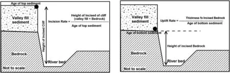
Fig. 4. Diagrammatic representation of methodology employed for the estimation of minimum long-term average uplift rate along the major faults [39].
5.2. Island Belt Fault zone (IBFz)
The Island Belt Fault zone is ~130 km long and ~5 km wide,which is delineated by narrow-folded deformation zone at the northern edge of the Island Belt Uplift. The Island Belt Fault is assumed to be buried under the Rann sediments. The IBF was displaced by several transverse strike-slip faults that divided the IBF into four discrete blocks (Pachham, Khadir, Bela and Chorar Islands),now are separated by the Quaternary plains namely Rann and Banni [19,48,68-71]. The existence of the IBF along the northern edges of the four islands is manifested by steep escarpment facing the Great Rann of Kachchh to the north.These four Islands are also affected by several secondary conjugated dipslip to oblique-slip faults and intrusive bodies [4]. Compared to other faults of the Kachchh Rift Basin, limited efforts have been made to understand the Quaternary tectonic activity along IBFz.Ngangom and Thakkar [68] provided general morphometric and morphotectonic analysis with evidences of structurally controlled landforms, suggesting multiple stages of upliftment in the Pachham, Khadir and Bela uplift while Chorar uplift depicted a single phase. Chowksey et al. [19] marked evidences of some geomorphic markers to prove an active tilting in the IBU region. The Quaternary depositional landforms like thick colluviums at the scarp base, reworked biomicrite sandstones (miliolites), fluvial terraces within the saddled valleys of Pachham uplift, incision in the raised Rann surface marked the role of neotectonics in the evolution and modification of the landforms in the IBFz. Khonde et al.[69]have marked the raised Rann sediments within the IBFz which can be due to active tectonic movement along the IBF.Chowksey et al. [70] reported the valley-filled Quaternary fluvial deposits and formation of strath terraces on the southern limb of folded IBF in the Pachham Island. These deposits were further documented with detailed study that dated them by Bhattacharya et al. [71] and estimated the upliftment rate of 0.2 ± 0.01 mm/yr.Kothyari et al. [27] and Dumka et al. [72] implemented geodetic method to estimate the deformation rates along various faults of the Kachchh Basin.The estimated the deformation rate of the IBFz in the Khadir Island was 1.8 mm/yr and Bela Island was 1.6-3.8 mm/yr. The variation of the upliftment rate and deformation rate in the various blocks of island may be due to occurrence of strike-slip faults across the IBFz. The occurrence of the 2006 M5.6 Bela Island earthquake in the and estimated DInSAR method obtained deformation rate of ~0.27 cm along the Khadir,Bela and Chorar region of Island Belt Uplifts indicates the active tectonic nature of the IBFz. Furthermore [43,44], also suggested the possibilities of generating moderate to large earthquakes along the IBFz in the future.
5.3. Gedi Fault zone (GFz)
The Gedi Fault zone is located in the eastern Kachchh near the northern boundary of the Wagad uplift (Fig.1). The Gedi fault can be easily identified as the E-W trending slope that delineates the Mesozoic sandstone from the Tertiary rocks. The folding related with faults are usually common in segmented blocks of faults,where the folds are associated with interlinking segments of the fault [22,23,28,29,31,33,73]. Two of the most significant tectonogeomorphic features that are observed in the GF zone are the river offset and ground upwarping, which are attributed to the compressional stresses exerting on the fault zone.The offset of the river channels in the GF zone might be due to the inter-connection of the three fault segments depicting a left lateral movement[29].Various geophysical studies suggested that the Gedi Fault is a strike-slip fault and the fault geometry is near vertical at the surface[27-29]. The Quaternary sedimentary record exists in the form of strath and cut-and-fill terrace along the Karaswali River. The terraces are unpaired in nature, and suggesting tectonic movement along the GF zone. The incision in terrace sequence which commenced at 4.2 ± 0.4 ka, and we believe that it has been dominantly regulated by uplift along GFz due to two reasons, 1)available climate records suggest prolong aridity during the 4 to 5 ka period from adjoining marine,fluvial and lacustrine archives of the western India and Arabian Sea [27-29,58,60,64] which rules out or suggests a minimal climate role and 2)presence of unpaired terraces, sedimentary surfaces and narrow uplifted zone ground along the GFz. Based on OSL chronology, the long-term average minimum uplift rate for GFz was computed as 0.6 mm/yr [27,29](Fig. 5a).
5.4. South Wagad Fault zone (SWFz)
The South Wagad Fault zone is located at the southern end of the Wagad upland in the eastern Kachchh which is severed into numerous wedge blocks encompassed by reverse and normal faults[27,28,31,33].The SWF demarcates the Mesozoic and Tertiary strata with a steeply southward dipping E-W trending scarp. Various remarkable tectono-geomorphic features like strath terraces,truncated alluvial fans, river offsets and incisions are observed in the SWF zone. The SWF has an intricate geometry of an anastomosing en ˊechelon fault with reverse and normal fault segments are alternately offset along the Principal Deformation Zone(PDZ)as inferred from the various geomorphic and geophysical analysis[27,38,43,44,74].The River Bambudi was studied for understanding the genesis of strath terraces,which are unpaired and show 12 m of incision hinting at tectonic movement along the SWFz. The Quaternary sedimentary record is in form of strath and cut-and-fill terraces along the Bambudi River. The incision in terrace sequence began at 3.1±0.7 ka,which was driven by the uplift along SWFz.The OSL dates suggested that the sediment deposition above the Tertiary bedrock started around 12.6±2.8 ka and sustained till 3 ka [38]. Depending up on the displacement of fluvial sediments and incision, two significant tectonic deformation are observed along the SWF from 12 to 1 ka [38]. The long-term average uplift rate as estimated from the OSL chronology for the SWF is 2.8 ±0.1 mm/y [28] (Fig. 5a).
5.5. Kachchh Mainland Fault zone (KMFz)
The KMF is the longest fault in the KRB,spanning about 170 km trending E-W from Lakhpat(west)to Bhachau(east).It is severed by numerous NW-SE,NNE-SSW and NE-SW trending transverse faults. The KMF can be geomorphologically recognized by the steeply northward dipping scarp in the Northern Hill Range(NHR).It is the point of contact that delineates the Mesozoic sandstone from Tertiary shale and Quaternary sediments. The Quaternary sediments can be found in the north-flowing rivers that crosses the KMF [32,40]. The active tectonic nature of the KMF has been illustrated from central and eastern segments [75,76], however,these studies lack chronological support.From various geomorphic and paleoseismic studies, it is concluded that the central and eastern segments of the KMF are most active in contrast with the western segment [32,75]. The estimated incision rates of the central and eastern segments are 2-9 mm/yr and 2.3-10 mm/yr respectively (Fig. 5a). However, these incision rates are estimated using the thickness of incision in fluvial sequence and not the strath terrace. Therefore, the incision rate obtained from the fluvial sequences is mainly controlled by climate and tectonic processes rather than only one process accountable. Prizomwala et al. [76]reported the tectonically regulated strath terrace sequence at Lothia river on the hanging wall block of the KMF and reported two major tectonic events during the Holocene period (i.e. 3 ka and<3 ka)and one during the Late Pleistocene period(>14 ka).On the basis of stratigraphy, geochemistry and OSL chronology, they suggested a minimum long-term uplift rate of 1 mm/yr for the eastern segment [32,77,78]. Correspondingly [75], reported a minimum long-term average uplift rate of 0.8 mm/yr for the Kaila River from the optical dates acquired from the valley and channel fill sequences of the north-flowing rivers in the eastern segment.
5.6. Katrol Hill Fault zone (KHFz)
The KHF is an E-W trending, south-dipping high angle reverse fault spanning about 75 km,and is the demarcating boundary of the Jurassic (Jumara) and Cretaceous (Bhuj) formations on the south and north respectively. The KHF can be geomorphologically expressed as a steeply northward trending slope on the surface in the Katrol Hill Range(KHR)[17,21,26,30,40,41,79-81].A minimum average slip rate of 0.23 mm/yr has been inferred from the paleoseismological studies for the active fault segment of the KHF since the last 30 ka,with the latest tectonic event identified around 3 ka[30,42]. Based on paleoseismological study [64], it is believed that the eastern part of KHF was more tectonically active compared to western part. Recent studies used strath terrace sequences minimum long-term average uplift rate of 0.8 mm/yr [42]. studied the sequences of Khari and Gunawari Rivers crossing through KHF and reported an incision rate of 3.1 mm/yr and 4 mm/yr respectively(Fig. 5a). In order to down cut the bedrock, the stream power should be highly dynamic. Since the Kachchh is a dry land region,the streams are not powerful enough to incise the bedrock[79,80].Therefore, it is hypothesized that the bedrock incision during the Late Quaternary period was attributed to tectonic activity[17,21,26,30,40,41,79,80]. The hanging wall block of the KHF is characterized by several gorges, offset channels, narrow deeply incised Quaternary miliolitic terraces and V-shaped river valleys,which are testimony to past seismic activity [17,21,26,30,40,41,79,80].
6. Discussion
6.1. Spatial variability in uplift rate and its implications
The sedimentary records suggest that the South Wagad Fault shows the highest long-term uplift rates in the Kachchh region~1-2 mm/yr [28,31,38]. This is also in conjuncture with DInSAR studies carried out by [73], which although being considered to be overestimated,shows relatively higher vertical deformation in the SWFz compared to other faults of the Kachchh (Fig. 5a). The cluster of seismicity along the Wagad block over the transpressional zone of the SWFz and KMFz also indicated that this zone is presently undergoing greater deformation in the Kachchh region[15,16]. Based on the various geomorphic evidences of active tectonics during the Holocene period[18,21,23,25,27,29,31,38,74],it is plausible to assume that the present pattern of spatial variation in tectonic activity has remained similar at least during the Holocene period.
The Kachchh region has witnessed several high amplitudes climatic as well as tectonic forces during the Late Quaternary period, as evidenced by its unique geomorphic configuration[22,23]. The presence of uplifted fluvial terraces, gorges, uplifted alluvial fan sequences, strath terraces etc are passive signatures of these external forcings.Nevertheless,the sedimentary signatures of climate and tectonic disturbances are often similar, like the formation of terraces at Lotia and Gunawari rivers [78] is deeply incised Quaternary sequences [14,32], colluvio-fluvial deposits at the base of fault generated scarps [18,21,77]. The realistic and accurate estimation of long-term uplift rates decoupled from climatic extreme events,requires a multifaceted approach involving proxies to weathering, landscape building and robust chronology [37].Maurya et al.[23]identified three surfaces S1,S2 and S3 relating to the Late Quaternary external forcing from the Southern Kachchh Mainland, however, the causal mechanism of their formation was qualitative and was not supported by strong weathering proxy or chronological datasets. Similarly [18,21], identified several debris flow deposits from the hanging wall block of the KMF and reported at least two phases of neotectonic activity along the KMF during Pre-Miliolite phase and post-Miliolite phase. However, the causal mechanism was questionable due to the lack of chronological support and weathering proxy dataset [42] documented the weathering proxy using sediment geochemistry along with strong OSL chronology for the KHF and the eastern KMF segments. They illustrated phases dominated by chemical weathering(i.e.climatic forcing) versus the physical weathering.
The geodetic studies based on DInSAR and PSInSAR suggested a very high uplift rate in eastern Kachchh (Fig. 5a), The GFz,central KMFz and eastern part of KHFz were considered to have highest uplift rate of 2-6 mm/yr [43,44,72,81]. The long-term minimum uplift rates suggested a range of 0.8-2.8 mm/yr for the Kachchh region, even though this may be underestimated due to the lack of continuous sedimentary deposits. This may be owing to the inadequate preservation potential in this seismically active as well as climatically arid landscape. Nevertheless, these rates can be used to assess the spatial variability of the various faults and segments of faults, for example, the SWFz shows the highest long-term uplift rate ~2.8 mm/yr followed by the KMFz(1.0 mm/yr) and the KHFz (0.8 mm/yr). The published results from the Kachchh region shows four major phases of tectonic movement during 11, 9, 3, and 2 ka (Fig. 5b) [64]. The impact of these events is regionally distributed along all the major faults of the Kachchh Rift Basin. The tectonic effect of the 11 ka event is well reflected in the KHF, KMF and SWF zones. The impact of the 9 ka event is only seen in the KMG and GF zone, whereas the 3 and 2 ka events are seen along the KMF, SWF, GF, and ABF.
6.2. Variations in seismicity and crustal deformation
The current study mainly concentrates on interpreting the spatial diversity in tectonic activity in the KRB. The present-day seismicity in the KRB is mostly concentrated in the step-over zone between the KMF and SWF zones. However, a few of the earthquakes are detected in the GF zone along the recently reactivated faults ascertained to be seismogenic [82,83]. Mandal et al. [82] suggested that the Wagad area started showing seismicity after the 2001 Bhuj earthquake. About 30 earthquakes in the GF zone are detected since 2006-14 with a magnitude range of 3.0-4.5 and the focal depths ranging from 5 to 20 km.The seismic catalogue of the Institute of Seismological Research (ISR), Gandhinagar,India indicated a significant number of aftershocks with a range of 2.2-5.7 falls in the Wagad region and the focal depths of 10-40 km.About 5 moderate earthquakes with magnitude ranges 4.1-5.7 are occurred in the GF zone from 2006 to 2008 which indicated its seismogenic nature [29,84]. Around 6 moderate earthquakes with magnitude ranges 4-5.5 in the SWF zone,and 3 earthquakes with magnitude ranges 4.2-5.1 in the NWF zone are detected in the Wagad region during 2005-2014, indicating the seismic activity of the Wagad region [28,83].
The strain field of the Wagad region was calculated from the GPS network of the Institute of Seismological Research by adopting the method developed by [28,72,81,85]. A surge of compressional strain towards the western portion of the Wagad uplift between the zones of KMF, SWF and GF is identified. Further, the western segment of the Wagad uplift especially between the KMF and SWF zones, shows higher strain accumulation (0.052 μ/yr)than the eastern segment,which is about-0.04 to-0.02 μ/yr.This higher strain accumulation in the western part is manifested in the form of deformation of various geomorphic landforms [27].The results from the GPS study in the Wagad uplift revealed that a deformation rate is estimated to be ~3±0.5 mm/yr,and is moving with a velocity of 46-51 mm/yr towards the N/N-E part which is in accordance with the movement of the Indian plate. This is only GPS constrained area in the Kachchh region, hence the compression rates of other active segments of KMF and KHF are yet not explored.
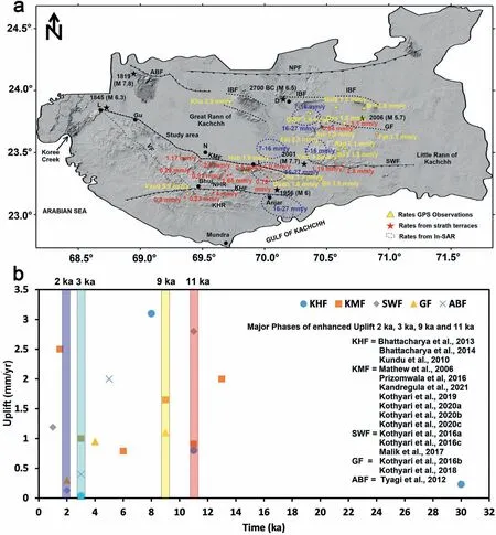
Fig. 5. (a) Digital elevation model of Kachchh Basin. Yellow triangle represents GPS station locations and rates [85]. The estimated rates from the bedrock strath terraces are highlighted by red stars[15,16,20,27,29,30,32,38,48,67,71,78,88].The observation of InSAR is given by blue dotted ellipse[83,89].(b)Graphical representation of time and uplift rates along various faults of Kachchh.
6.3. Seismicity in the Kachchh Rift Basin

Fig.6. (a)Seismicity Map of the Kachchh Rift Basin recorded in the period of 2006-2017(modified after Ref.[90])(b)Map shows the distribution of strain rate in the Kachchh Rift Basin,derived from the GPS network of the Institute of Seismological Research.Maximum compressional strain(0.052 μ strain/year)strain is observed between SWF and NWF zone.Note that the negative sign of contours indicates an increasing trend in compressional strain[28,38].(c)Focal mechanism of earthquake in the eastern Wagad area shows dominant strike slip motion (after Ref. [27]).

Table 1 List of historical earthquakes occurred in Kachchh and its neighbourhood regions[After[16]] and references there in].
At present, the seismic activity in the Kachchh Rift Basin is mostly confined to the KMF, SWF and GF zones (Fig. 6a).However, quite a few earthquakes are recorded in the Gedi Fault (GF) zone near the northern part of Wagad, along newly activated faults that are inferred to be seismogenic [27,82-84].The Wagad area was reactivated after the 26 January 2001 Bhuj earthquake [82]. In the GF zone, around 30 earthquakes(M3.0-4.5) have been recorded with focal depths in the range of 5-20 km during the year 2006-2014. The earthquake catalogue of the Institute of Seismological Research (ISR),shows that a large number of aftershocks (M2.2-5.7) occurred in the Wagad area with focal depths ranging from 10 to 40 km.A few moderate earthquakes such as the M5.0 February 2006,M4.8 February 2006, M5.7 March 2006, and M4.1 April 2008, are associated with the GF [29,85]. This indicates that the GF is still seismically active. In the central and southern parts of the Wagad area, a few moderate earthquakes of M4.5 (Sept.2005), M5.5 (2006), M4.7 (May 2007), M4.5 (March 2008),M4.3 (Aug. 2011), and M4.0 (April 2012) are found to be associated with the SWF, whereas the M4.2 (May 2011),M4.5 (March 2013), and M5.1 (2014) earthquakes are associated with the NWF [27,29,74]. The occurrence of these moderate earthquakes suggests that the SWF and NWF are seismically active [29,38]. The detailed records of historic earthquakes that occurred in Kachchh Rift Basin are provided in Table 1 [16].
The strain field of the KRB was computed using the Global Positioning System (GPS) data recorded from the GPS network at the Institute of Seismological Research (ISR), Gandhinagar.Strain was estimated using primary and secondary strain axes in the grid nodes of 5 × 5 Km[28,38,85]. The estimated strain rate of the KRB indicates that the strain is increasing from west to east. The maximum strain rate -0.052 micro-strain (μ/yr in the KRB is concentrated in between the fault zones of SWF and NWF (Fig. 6b). The eastern part of the KMF shows higher strain rate (-0.028 to -0.042 μ/yr) than the central and western parts(-0.014 to -0.024 μ/yr) (Fig. 6b). Further, the present-day seismicity is also concentrated between the eastern part of the KMF and the SWF zones ([27], Fig. 6c). It is believed that the strong crustal heterogeneities in the step zone between the KMF and SWF zones are responsible for the accumulation of the large crustal strain that resulted in high seismicity in the KRB[27]. The results of the compressional strain rates in the KMF zone are well corroborated with the InSAR derived displacement rates, as the eastern part of the fault zone shows higher displacement values than the central and western parts[89].
6.4. Socio-economic status of the Kachchh region
The Kachchh district of western Peninsular India is the largest district of Gujarat, covering an area of approximately 45,652 km,which is more than 23% of the total area of the Gujarat. Since the last decade, the population, commercial and industries are tremendously increasing in the Kachchh region.The record shows the population growth increased by 61% after the 2001 Bhuj earthquake of M7.7. The Kachchh region has been rapidly emerging as an industrial hub since the past two decades and it adopted a modern but unsafe infrastructural design. Most of the infrastructure in this region was built without following the standards of earthquake resistant design during construction, even though it is a highly prone zone of destructive earthquakes.
7. Concluding remarks
The available information of the Kachchh region suggests that the various studies so far have adopted ambiguous methods,however, the region lacks regional reconstruction. Following are some of the salient comprehension and identified future avenues,which are vital for understanding the evolution of this complex intraplate region.
• The observations and causes of variability in the uplift rates across the various active faults in the KRB suggest a complex geological history of Kachchh at least during the Quaternary period. The vertical uplift rates along the major active faults range from 0.8 to 2.8 mm/yr, which hint at variable tectonic compressive stress regime prevalent in the KRB.
• The spatial variation in long-term uplift rate along various segments of the KMFz, KHFz, SWFz, and IBFz suggest a partitioning of tectonic stresses infused by transverse structures.The presence of such transverse structures is testified by the characteristic geomorphic signature in the Northern Hill Range, Island Belt Uplift, Katrol Hill Range and Wagad Uplift.
• Another basic and important element is, the understanding of the geometry of some of these major faults (KMFz, IBFz ABFz),which is still debated [18,45,64]. The information on the dip of faults is vital for realistic seismic hazard analysis. Despite the continuous seismicity, there have been limited shallow as well as deep geophysical studies [16,79,86,87], which characterize these tectonic elements. The present strike-slip movement along the major faults of the basin is evident from the earthquake focal mechanism.
• Intriguingly, the Kachchh region providing magnificent opportunity to visualize and analyse earthquake generation processes,has been ill-studied for non-seismic external forces, which is equally vital for a comprehensive understanding of landscape and effect of tectonics.
• According to the 2011 census,the population expanded by 33%and the infrastructure development has been boosted to a significant extent in the past two decades,but the lacks of earthquake resistant designs put the lives of the people in grave danger. Hence, critical evaluation should be made on geological, geomorphological, hydrological and socioeconomic aspects which will aid in accurate assessment of seismic hazard.
Conflicts of interest
The authors declare that there is no conflicts of interest.
Acknowledgement
We are thankful to the Ministry of Earth Science(MoES),Govt.of India for financial support((MoES/P.O.(Seismo)/1(270)/AFM/2015))under the Active Fault Mapping program. GCK is thankful to Director General Institute of Seismological Research(ISR)for support,encouragement and permission to publish this work. Authors are thankful to Dr. S K. Biswas, for his suggestions in improving manuscript.
杂志排行

Geodesy and Geodynamics的其它文章
- Response of drainage to tectonics and PS-InSAR derived deformation study in Bilaspur, northwestern Himalaya, India
- Relative active tectonics evaluation using geomorphic and drainage indices, in Dadra and Nagar Haveli, western India
- Manifestation of earthquake preparation zone in the ionosphere before 2021 Sonitpur, Assam earthquake revealed by GPS-TEC data
- Integrated water vapor during active and break spells of monsoon and its relationship with temperature, precipitation and precipitation efficiency over a tropical site
- Geodetic characterization of active Katrol Hill Fault (KHF) of Central Mainland Kachchh, western India
- Crustal deformation measurements by global positioning system(GPS) along NSL, western India