The relationships between selected soil properties and caesium-137 identify organic carbon, nitrogen and water soluble phenols as indicators of soil erosion processes in dif ferent forest stands
2021-12-24FedericoRomeoPaoloPortoCarmeloMallamaciAdeleMuscolo
Federico Romeo · Paolo Porto · Carmelo Mallamaci ·Adele Muscolo
Abstract In the last few decades, the use of environmental radionuclides, particularly caesium-137 ( 137 Cs), represented one of the most valid methods for estimating soil erosion.However, the cost associated with the use of the equipment needed for radiometric analyses is still high and, for this reason, f inding more easily measurable indicators can be useful.There is a strong correlation between 137 Cs, organic carbon(OC), nitrogen (N) and water soluble phenols (WSP) exists,indicating the latter parameters as possible early indicators of soil erosion. Based on the above assumptions, the main purpose of this work is to identify specif ic soil chemical parameters able to indicate early triggering of soil erosion.Specif ically, several soil parameters such as pH, electric conductivity (EC), WSP, OC, N and C/N have been evaluated against 137 Cs and on a comparative basis. In addition, since the rate of soil erosion depends on the degree of coverage and canopy structure, two dif ferent tree species ( Pinus nigra laricio Poir. and Fagus sylvatica L.) have been considered in this contribution in which ten dif ferent scenarios of forest management have been analysed. The results show that the reduction in tree cover of managed sites triggers erosion and nutrient loss processes. It has been observed that the loss of 137 Cs, compared to the control areas, is closely correlated with those of WSP, OC and N. These parameters (WSP, OC and N), more easily assessable, can be a valid tool to understand easily, triggering of erosive phenomena.
Keywords 137 Cs · Erosion indicators · Forest thinning ·Beech forest · Pine forest
Introduction
Soil erosion/degradation depends on many factors such as soil characteristics, ground slope, vegetation cover and distribution, as well as amount and intensity of rain, which in turn can severely af fect soil quality and productivity by removing the most fertile topsoil (Zuazo and Pleguezuelo 2008). Soil erosion depends also by anthropic interventions both in agriculture than in forest f ields. Considering the key role played by soil in view of the planet’s sustainable future,and taking into account that soil is lost from terrestrial areas from 10 to 40 times faster than its renewal, imperilling food security and environmental quality (FAO 2017), it is of primary importance, nowadays, to individuate, as soon as possible, the triggering of soil erosion process.
Forests play a pivotal role in maintaining the environmental ecological balance, and are strictly connected with soils with a great inf luence on each other and on the wider environment. Nowadays, the growing population growth and the consequent request for timber and f ibres, in addition to the growing global market concurrence are exacerbating the pressure on forest ecosystems. All this is leading to an intensif ication of forest management activities,which if improperly executed can result in serious damages to soil, with organic matter loss, nutrient cycle disequilibrium (Johnson 1992; Neary et al. 1999; Balboa-Murias et al. 2006; Nilsen and Strand 2008), and soil compaction.Thus, appropriate forest management practices, to maintain or improve forest cover on erosion-incline soils, could help to control or reduce soil erosion processes.
Considering that the ef fects of anthropogenic forest interventions are not visible on soil in a short time, there is now the increasing exigency of individuating techniques easy and cheap to detect the ef fect of silvicultural practices on soil properties. In the past, various attempts tried to early individuate erosive phenomena, primarily based on models and calculation procedures that required detailed information about soil and plant characteristics, climate,topography and human impact (Morgan et al. 1992;Renard and Freimund 1994; De Roo et al. 1996). However, these methods require several physical assumptions and remain conf ined to geographical zones where calibration and validation are possible. Since the early eighties, the use of environmental radionuclides particularly caesium-137 (137Cs), represented one of the most valid methods for estimating soil erosion. This technique based on the general assumption that, following bombing fallout or nuclear accidents,137Cs reaching the earth’s surface,was quickly and intensely absorbed by soil surface and redistributed into the landscape with the erosion, transport and deposition of soil particles and sediments. For this reason,137Cs was used to prove velocity and modality of soil redistribution through erosion processes in dif ferent environments (Walling 1998; Porto et al. 2001, 2003,2016; Di Stefano et al. 2005; Porto and Walling 2012).However, the use of this technique requires the availability of expensive equipment that may be beyond the budget of most institutions. In this respect, rose the need to explore alternative indicators of soil erosion to fulf il the necessity to give information in areas where no measurements of137Cs are available. A previous study (Muscolo et al. 2014) individuated soil biological properties able to evidence, in a short-term, modif ication in soil quality in forest ecosystems. The authors explored the use of microbial biomass carbon (MBC), f luorescein diacetate (FDA)hydrolysis, and water-soluble phenols (WSP), in addition to soil organic matter (SOM), to assess the ef fects of forest management practices on soils, identifying WSP as an early warning indicator of soil quality changes.
Subsequent studies (Romeo et al. 2020a, b) investigated in aFagus sylvaticaL. stand, how dif ferent forest management practices (traditional thinning that removed 12% of total volume and innovative thinning that removed 27% of total volume) af fected soil properties, using both137Cs and biological soil parameters. They demonstrated the existence of a strong correlation between137Cs and OC, N and WSP,indicating the latter parameters as possible early indicators of soil erosion. Based on the previous f indings and considering that indicators of soil quality must be selected according to soil use and managements, our work hypothesis was to extend the investigation to other forests dif ferently managed in order to have a more representative study.
The aim was to individuate the most suitable parameters to be used as possible early warning indicators of soil erosion in respect to the dif ferent forest management practices.In the present study, soil chemical parameters pH, EC, WSP,OC, N and C/N, have been selected on the basis of previous results (Romeo et al. 2020a) and evaluated against137Cs, on a comparative basis, inPinus nigra laricioPoir.andF. sylvaticaforest subjected to 10 dif ferent types of management namely Undisturbed forest (UF), traditional thinning (TT),innovative thinning (IT), coppice (C), high monoplane forest (HM), biplane forest (HB), beech forest clear-cut (BCL),beech undisturbed forest (BUF), pine stand 52% canopy cover (PF1) and pine stand 63% canopy cover (PF2).
Our main objective was to identify universal and specif ic early warning indicators of soil degradation to precociously estimate how forest management af fects the dynamic of soil processes to prevent irreversible damage to soil ecosystem functioning.
Materials and methods
Study areas
The investigation was carried out in three study areas [Mongiana (VV), Cinquemiglia (CS), and Ferraina (RC)] located across the Calabrian Apennine Mountain with beech and pine as vegetation (Fig. 1). In detail, eight dif ferent beech forests (Fagus sylvaticaL.) and two Calabrian pine forests(Pinus nigra laricioPoir.), were selected for the investigation. Details of each study site are provided below.
Mongiana site
Mongiana study site (Fig. 1) is located in the Southern Apennine (Calabria Region), “Serre” mountains, in Mongiana (VV). The biogenetic reserve (Natura 2000 site) called“Marchesale” is a high forest ofF. sylvaticawhich covers 1234 ha in charge of National Forest Service of Italy.
The main characteristics of the area are summarized in Table 1. The experimental area is of ca. 30 ha, covered by 80-year-old high beech forest. In this area, three sub-areas(three ha each) have been identif ied for each dif ferent silvicultural thinning (3 beech forest typologies × 3 replicates = 9 plots of 1000 m2). Specif ically, an unmanaged zone for over 30 years (UF), an area traditionally managed (TT), and an area with an innovative treatment (IT) have been individualized (Table 2). Traditional management was a thinning from below with a moderate intensity, which eliminated all the dominated trees and the worst dominant trees (on average,ca. 12% of total volume resected). The innovative treatmentwas an experimental thinning that consisted in keeping the 50 best trees per hectare by collecting 5 or 6 trees closer to them, regardless of their social position (on average, about 27% of the total volume removed). The best trees were identif ied according to their conformation in terms of diameter,height and vegetative vigour. In doing so, an attempt was made to further promote their development and evaluate the ef fects of this experimental management.No signif icant dif ferences were found between the dendrometric parameters in these areas before the silvicultural interventions (Picchio et al. 2016 ; Coletta et al. 2017). The three treatment sites were similar as slope, orientation and soil types. According to USDA soil classif ication, the soils are Inceptisols and Entisols (Soil Survey Staf f 2010).
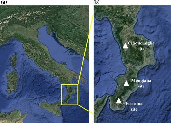
Fig. 1 The study area ( a) and the three selected locations b : Ferraina, South Calabria,Mongiana, central Calabria,Cinquemiglia, North Calabria
Cinquemiglia site
Cinquemiglia study site (Fig. 1) is located in the coastal chain in the northern part of Calabrian Apennines, within an area belonging to the “Natura 2000” site in Fuscaldo (CS).
The morphology of the area varies from valley with small streams to particularly steep slopes, up to f lat areas.The slopes did not exceed 20%. The surface horizon of the soil is, in this area, rich in organic matter, which gives the soil a typical dark brown colour, however its thickness may vary depending on the morphology and intensity of erosive phenomena. The main characteristics of the area are summarized in Table 1.
Within an area of about 394 ha and at an altitude ranging from 600 to 1200 m (a.s.l.), three dif ferent scenarios were identif ied, all with beech (F. sylvatica) as dominant species:(C) a coppice; (HM) high forest with vertical monoplane structure; (HB) high forest with biplane vertical structure(Table 2).
For each scenario (C; HM; HB) three plots of 1000 m2each and of similar slope were selected (3 forest typologies × 3 replicates = 9 plots).
The coppice (C) under study highlighted about 1300 stumps per hectare with wood volumes of about 300 m3ha(Ciancio et al. 2007).
Dendrometric information of the monoplane forest (F)can be deduced from previous works carried out in beech woods of the same type located in the Calabrian Apennines(Ciancio et al. 2008). This stand has a monoplane vertical structure of about 80–110 years. The number of plants and the relative average volume were 381 ind. ha−1and 548 m3ha−1, respectively (Ciancio et al. 2008).
The vertical biplane structure, obtained through targeted thinning operations over the decades (Ciancio et al. 2008),showed a number of plants between 60 and 90 ind. ha−1aged between 100 and 120 years, and about 400–450 ind. ha−1to constitute the dominated layer (30–40 years) with f inal volumes of about 460 m3h−1.
Ferraina site
Ferraina site (Fig. 1) is located within the highest slope and in the southernmost part of the Aspromonte National Park,in Samo (RC). The area is composed by well-structured but not particularly deeply soil, with moderate slopes ranging between 9 and 22%. The main characteristics of the area are summarized in Table 1.

Table 1 Main characteristics of Mongiana, Cinquemiglia and Ferraina sites
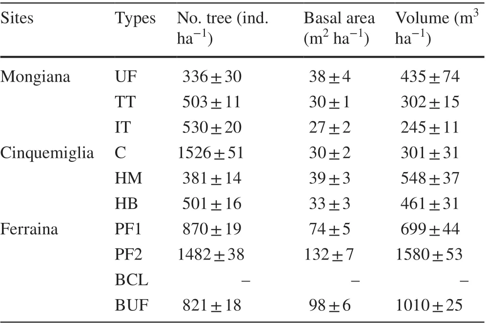
Table 2 Means and standard deviations (n = 3) of main dendrometric characteristics in Beech and Pine stands
For the purpose of this work, two stands with Calabrian pine (P. nigra laricio) and dif ferent canopy covers, and two stands with beech (F. sylvatica) (one of which was cut in 2009) have been selected. Specif ically, the two pine forest stands, namely PF1 and PF2 were constituted by 50-year pine planted in the late 1960s during a massive re-af forestation program (ca. 150.000 ha). The two beech forest stands,namely BCL (beech forest clear-cut) and BUF (beech forest undisturbed) consisted of seminatural high beech forests (ca.140 years old). BUF was not disturbed by cutting activities,excepted for a minimum removal of trees in the past decades;on the contrary, BCL was cleared-cut in 2009 and then left to evolve naturally.
In a previous contribution, Altieri et al. ( 2018) reported the results obtained from 4 small plots (300 m2) identif ied in this area. These plots have been revisited in 2018 and the area of sampling was extended to 1000 m2for each plot.Similarly, two more replications of the above described plots have been established in order to be consistent with the sampling programme assumed for the other two sites. Finally, for each scenario (PF1, PF2, BCL and BUF) 3 plots of 1000 m2each were considered in this investigation (4 forest typologies × 3 replicates = 12 plots).The main dendrometric characteristics of each study sites are summarized in Table 2.
Sampling procedure
As it was described above, in each of the ten dif ferent scenarios (UF, TT, IT, C, HM, HB, PF1, PF2, BCL and BUF), three representative plots (1000 m2) were selected for sampling (see Fig. 2). In these 30 plots, three separate soil sampling campaigns were undertaken following thescheme illustrated in Fig. 2. Sampling campaigns were carried out in May 2016 in Cinquemiglia site, in May 2018 in Mongiana site, and in June 2018 in Ferraina site(Fig. 2).

Fig. 2 The sampling strategy adopted in the plots established within the experimental sites
Soil cores were collected to analyse137Cs and chemicalphysical properties, in areas with almost identical slope, to avoid of sampling near to the tree trunks to minimize the ef fect of stem f low on the f inal137Cs inventories.
Totally, 20 f inal composite soil cores (10 for radiometric measurements and 10 for chemical-physical and biological analysis) were picked up with a 10-cm-diameter steel core tube to a depth of ca. 35 cm.
Each composite core used for137Cs and soil analysis come from 9 single sectioned cores (from 3 plots of the same treatment and sampling campaign) combined layer by layer (as shown in Fig. 2).
For the radionuclide measurements, the soil cores were divided every 2 cm (up to 30 cm in the case of caesium prof iles) for better data accuracy while, only the f irst 15 cm of soil were considered following the same methodology for all other analyses.
This kind of sampling was needful to attain the activity of137Cs distributed in the soil prof ile and to account for micro scale variability. The f irst 15 cm (0–15 cm) of soil have been taken into account for soil analyses, following the scheme used for radionuclides. Soil samples were air-dried, and sieved (2 mm mesh). For the radiometric assay, samples were oven-dried at 105 °C for 48 h,sieved to separate the < 2 mm fraction and packed in plastic pots or Petri dishes to detect137Cs activity by gamma spectroscopy.
Radiometric analyses for 137 Cs content
137Cs activity and its subsequent vertical distribution in the soil prof ile was detected by using a gamma spectrometry.Two Canberra p-type HPGe detectors, model GX4020,were utilized for the analyses as reported in a previous work of Romeo et al. ( 2020a).
Soil analysis
pH was detected as reported in Romeo et al. ( 2020a).Electric conductibility (EC) was assessed by using Hanna instrument conductivity meter in a ratio of 1:5 residue/distilled water. Total water-soluble phenols (WSP) were assessed with Folin–Ciocalteu reagent (Box 1983). Tannic acid the standard used, WSP concentration was expressed as tannic acid equivalents. Total organic carbon (C) was determined following the method of Walkley and Black( 1934), and subsequently converted to organic matter by multiplying the percentage of carbon by 1.72. Total nitrogen (N) was measured following the Kjeldahl method( 1883).
Statistical analysis
To explore relationships among soil parameters (0–15 cm depth) and six dif ferent forest stands (9 situations), datasets were analysed using Pearson’s correlations, Multivariate Analysis of Variance (MANOVA) and T-test for paired values. Correlations was carried out using the software PAST (Hammer et al. 2001).
MANOVA analysis was carried out for evaluating the ef fects of dif ferent types of forest and their interaction on the set of soil parameters and137Cs. Finally, a T-test was used for paired values to evaluate signif icant dif ferences.This last analysis allowed to verify if the thinning inf luenced the properties of the soil, including the activity of the radionuclide137Cs and if the impacts were similar. Manova and T-test were carried out using SPSS software (IBM Corp.2012).
Results and discussion
137 Cs prof iles distribution
The137Cs distribution prof iles, reported in Figs. 3, 4 and 5,showed a decreasing trend with soil depth, typical of forest stands (Porto et al. 2003). The depth scale in Figs. 3, 4 and 5, is plotted as cumulative mass (kg m−2), instead of depth(m), to avoid to consider down core variations in soil bulk density and to make the prof iles comparable one another.
In Mongiana site, the137Cs prof ile in UF, here considered as reference site, showed an inventory value of 4577 Bq m−2(Fig. 3). In TT and IT, the137Cs profiles (Fig. 3) showed inventory values of 3620 and 1490 Bq m−2, respectively. Both profiles documented inventory values lower than the reference value and, for this reason, they are both indicative of soil erosion. However, the much lower137Cs inventory in IT suggested that the triggering of erosive phenomena was very pronounced in this area compared to TT area where a traditional thinning was performed. In terms of137Cs activity, a visual inspection of the prof iles shown in Fig. 3 suggested that the soil surface of the areas under forest management (TT and IT), had lower137Cs concentrations (between 50 and 100 Bq kg−1) than the reference area. This condition conf irmed that the top soil of the prof iles related to TT and IT was removed by erosion.
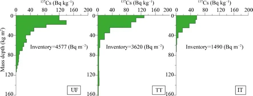
Fig. 3 Cesium prof iles distribution referred to the Mongiana sites ( UF undisturbed forest, TT traditional thinning, IT innovative thinning)
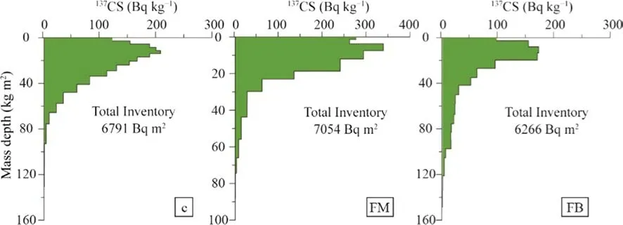
Fig. 4 Cesium prof iles distribution referred to the Cinquemiglia sites ( C coppice stand, HM high monoplane forest, HB high biplane forest)
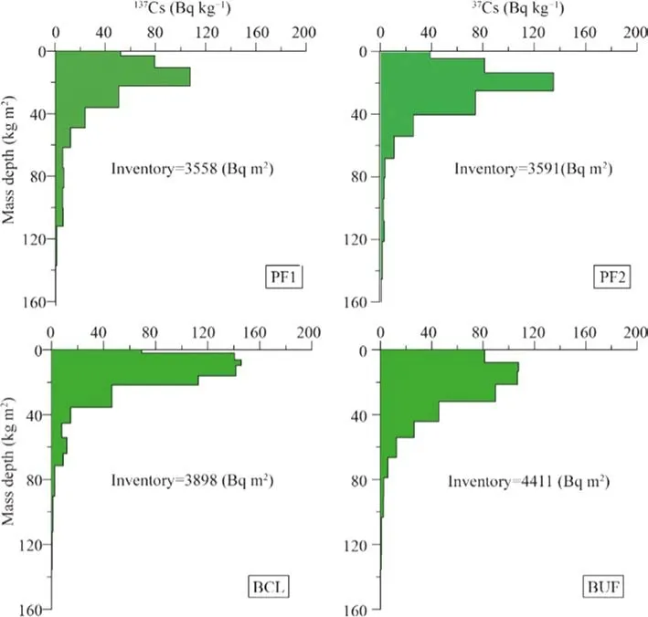
Fig. 5 Cesium prof iles distribution referred to the Ferraina sites [PF1 (52% canopy cover)and PF2 (63% canopy cover),pine stands; BCL, beech forest clear-cut; BUF − beech undisturbed forest]
The137Cs prof iles in Cinquemiglia site (C, HM, HB)documented a higher radionuclide inventory than in Mongiana area (Fig. 4). This was mainly due to the dif ferent geographical location and the dif ferent137Cs fallout occurring in this area that is linked to a dif ferent rainfall regime.The rainfall data obtained from the meteorological station in‘Laghitello’ (located very close to the study area) showed,for the period 1940–2000, a mean annual precipitation of 1937 mm that makes this territory as one of the most humid areas of Calabria. The137Cs prof ile related to the monoplane forest HM (Fig. 4) documented a total inventory value of 7054 Bq m−2. This area, due to forest stability conditions,less management activities and minor disturb in its composition, has been individuated as a reference area and it can be used for comparison with the other two scenarios in the same site.
Conversely, erosive phenomena occurred in the coppice managed area, characterised by a137Cs inventory of 6791 Bq m−2, and in the biplane forest (137Cs inventory = 6266 Bq m−2), where a decrease in more than 100 Bq kg−1in the surface soil layer compared to HM was observed both for C and HB areas (Fig. 4).
The137Cs prof iles obtained from the pine stands located in Ferraina site (Fig. 5) showed no signif icant dif ferences between the two scenarios characterised by dif ferent tree cover. In addition to a similar distribution along the soil prof ile, the PF1 area indicated a similar inventory value of137Cs (3558 Bq m−2) compared to the PF2 area (137Cs inventory = 3591 Bq m−2). In the clear-cut beech stands there was a decrease in137Cs inventory (4894 Bq m−2) compared to the undisturbed area (5059 Bq m−2) that was selected on purpose (see Altieri et al. 2018). The lack of tree cover in BCL certainly inf luenced the triggering of erosive processes. In the same area of Ferraina, the lowest values can be observed in pine stands compared to beech stands, a phenomenon mainly due to the tree canopy conformations and to the degree of coverage they can of fer.
Merging the prof iles shown in Fig. 3, 4 and 5, with the bulk density values, it was possible to calculate137Cs inventory (Bq m−2) and mass activity (Bq kg−1) for a f ixed depth.This calculation was made for the soil depth corresponding to the f irst 15 cm, to render feasible the paragon with the other soil properties of the corresponding layer.
These results evidenced important dif ferences between the estimates of soil erosion in relation to the type of treatment on the basis of the evident decrease in137Cs in respect to the intensity of the thinning. Our data are in agreement with the work of Romeo et al. ( 2020a) carried out in aFagus sylvaticastand with different thinning treatments. The authors reported that the amount of137Cs decreased, and its greatest decrease was observed when the intensity of the treatment increased. The data obtained contribute to strength the use of137Cs as tracer to display soil erosion processes in forestry areas .
Soil properties
In Mongiana site, the pH was slightly higher in innovative thinning (IT) than in TT and UF areas. The soil were sub-acid with pH values ranging from 5.4 to 6 (Table 3).Electrical conductivity did not vary signif icantly among the treatments (Table 3) while WSP, OC, N (UF > TT > IT)decreased with increasing forest thinning (Table 3). More thinning intensity more the decline was. All the parameters were signif icantly and positively correlated with137Cs (Bq m−2, Bq kg−1) (Table 3).
In Cinquemiglia site, the pH did not show signif icant differences between the treatments, ranging from 4.5 (HB) to 5 (C). The highest value of EC (575 μS) was observed in the coppice area (C), while the lowest (493 μS) in HM (Table 3).Also, in this area, WSP, OC, N decreased when thinning intensity increased with the highest values in HM, followed by C and HB (HM > C > HB). All the parameters were signif icantly and positively correlated with137Cs (Bq m−2, Bq kg−1), showing the same trend of Mongiana (Table 3).
In Ferraina the pH was slightly lower in BCL than in the other sites (PF1, PF2, BUF). In general pH varied from 5.3 to 6.1 (Table 3). The highest value of EC (411 μS) was observed in the undisturbed beech forest (BUF), while the lowest (162 μS) in PF1 (Table 3). WSP, OC, N followed the same trend (PF2 > PF1; BUF > BCL) of the other two sites decreasing with increasing forest thinning (Table 3). WSP,OC, N were positively and signif icantly correlated to137Cs(Bq m−2) conf irming the data obtained in the other two sites.
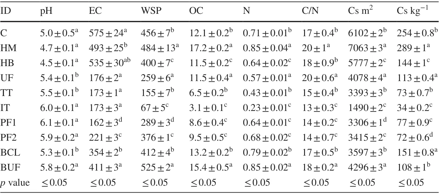
Table 3 Mean values and standard deviations of soil parameters referred to 0–15 cm soil layer

Table 4 Pearson’s correlations coef ficient ( r) between 137 Cs (Bq m −2 , Bq kg −1 ) and the soil parameters (pH; EC; WSP; OC; N; C/N),referred to 0–15 cm soil layer in (C, coppice stand; HM, high monoplane forest; HB, high biplane forest; UF, undisturbed forest; TT,traditional thinning; IT, innovative thinning; BCL, beech forest clearcut; BUF, beech undisturbed forest; PF1 and PF2, pine stands)
The Pearson’s correlation coef ficient between137Cs and soil parameters (Table 4) showed that pH was not correlated with137Cs and with the other chemical soil parameters.EC and C/N showed a poor correlation. On the contrary, a strong correlation between137Cs and OC, N and WSP in all the study sites and in all the treatments was observed(Table 4). The majority of previous works demonstrated a strong correlation mainly between soil organic matter and137Cs (Zhang et al. 2006; Teramage et al. 2013), Nakamaru et al. ( 2007) and Fujii et al. ( 2018) explained this correlation with the ability of SOM to adsorb137Cs in an exchangeable forms, enhancing also its mobility. Successively, Romeo et al ( 2020a) evidenced for the f irst time in soil underFagus sylvaticasubject to dif ferent thinning a correlation between137Cs and other soil parameters such as water soluble phenols and nitrogen. Our results conf irm in dif ferent forest stands and under dif ferent forest system treatments the established relationship between137Cs and other soil parameters, providing an alternative diagnostic tool through the use of soil chemical parameters as indicators to quantitatively evaluate the soil losing in the context of forest management.
Conclusion
Understanding how forest management can af fect soil performance and processes in a short term in a cheap and easy way is now feasible. The selected indicators, in respect to137Cs, are sensitive to changes external induced,able to integrate and to correlate to other soil properties,reproducible in the use and inexpensive. The results of this study conf irm, even under dif ferent vegetation types and thinning practices, the interconnection of WSP, C, N with137Cs and the ability of these chemical soil parameters to give early indications on the triggering of erosive processes. This study can be a useful support to predict the dynamic behavior of soil processes at the impact of management practices representing a relevant tool for determining the sustainability of forest practices in a short period of time. The estimation of erosion velocity given by the137Cs indicates that attention must be paid when cutting operations in forest areas are planned. The estimation of erosion velocity given by the137Cs technique points out that it is necessary to properly plan cutting operations in forest areas to avoid triggering of soil erosion process.
AcknowledgementsThe study was supported by the Coordinated Research Project (CRP) D1.50.17 within the framework of the International Atomic Energy Agency (IAEA). The authors are also indebted to the ARPACAL for providing rainfall data used in this study.
FundingOpen Access funding provided by Università degli Studi Mediterranea di Reggio Calabria.
Open AccessThis article is licensed under a Creative Commons Attribution 4.0 International License, which permits use, sharing, adaptation, distribution and reproduction in any medium or format, as long as you give appropriate credit to the original author(s) and the source,provide a link to the Creative Commons licence, and indicate if changes were made. The images or other third party material in this article are included in the article’s Creative Commons licence, unless indicated otherwise in a credit line to the material. If material is not included in the article’s Creative Commons licence and your intended use is not permitted by statutory regulation or exceeds the permitted use, you will need to obtain permission directly from the copyright holder. To view a copy of this licence, visit http://creat iveco mmons.org/licen ses/by/4.0/.
杂志排行
Journal of Forestry Research的其它文章
- Genome-wide identif ication and cold stress-induced expression analysis of the CBF gene family in Liriodendron chinense
- Decay rate of Larix gmelinii coarse woody debris on burned patches in the Greater Khingan Mountains
- Characterizing conservative and protective needs of the aridland forests of Sudan
- Point-cloud segmentation of individual trees in complex natural forest scenes based on a trunk-growth method
- Accuracy of common stem volume formulae using terrestrial photogrammetric point clouds: a case study with savanna trees in Benin
- Appropriate search techniques to estimate Weibull function parameters in a Pinus spp. plantation
