Altitude-dependent distribution of 137Cs in the environment:a case study of Aragats massif, Armenia
2020-04-26·····
· · · · ·
Abstract This paper considers the distribution of technogenic 137Cs and naturally occurring radionuclides: 238U,232Th and 40K concentrations in soils and 137Cs in atmospheric dry depositions by altitudinal belts of the Aragats mountain massif, Republic of Armenia. Undisturbed soil samples were collected at altitudes from 1000 to 3200 m.For the determination of geochemical variability, two soil sampling campaigns were undertaken. Atmospheric dry depositions were sampled from five stations at 1100–3200 m collected onto organic fiber filters between June and December 2016. 137Cs activity was measured using a high-purity Germanium detector coupled to a multichannel analyzer (Canberra). Results indicated that specific activity of 137Cs in soils at 1000 m is 495–528 Bq m-2, and at 3200 m is 10,500–11,470 Bq m-2. No correlation observed for 137Cs versus naturally occurring radionuclides, which varies in distribution by altitude. Specific activities of 137Cs in dry atmospheric depositions varies from 1.06 at 846 m to 2.37 Bq m-2 per quarter at 3200 m and increases as the altitude increases. Activities of 137Cs in soil and dry atmospheric deposition correlated significantly, and 137Cs activity in soils and atmospheric dry depositions decrease as the absolute altitude decreases. The 50-year effective dose from exposure to 137Cs fallout varies with altitude from 0.007 to 1.42 mSv.
Keywords 137Cs · Distribution by altitude · Naturally occurring radionuclides · Topsoil · Dry atmospheric depositions · Gamma radiation · Mountain regions
1 Introduction
Radioactive fallout in the terrestrial environment from nuclear weapons tests and accidental emissions from nuclear power plants (NPP) is the major source of radiocesium in the environment.The long-lived137Cs isotope of
radioactive cesium is one of the major dose-forming radionuclides resulting from uranium and plutonium fission. The total release of137Cs into the stratosphere from atmospheric nuclear testing was approximately 9.6 × 10¹⁷Bq and produced a fallout density of 3.42 × 10³Bq m-2in the northern hemisphere,0.86 × 103Bq m-2in the southern hemisphere, and 3.14 × 10³Bq m-2average globally (UNSCEAR 1982).As of 1985,mean fallout density of137Cs was estimated as 3.4 × 10³Bq m-2in the former USSR (Moiseev 1985).Under normal operating conditions at NPPs, release of radionuclides including137Cs are insignificant(UNSCEAR 1982; IAEA 2001). Meanwhile, in the case of NPP accidents, radioactive materials are released into the environment.Up to the present,hundreds of accidents with varying degrees of severity have been documented. However, only some of these accidents released significant amounts of radionuclides into the environment. The Chernobyl NPP accident of 1986 has been the worst to occur in the entire history of nuclear energy (Beresford et al. 2016). The reactor destroyed in the accident released huge amounts of radionuclides 1.85 × 10¹⁸Bq (RNGs excluded) to the environment. The activity of radioactive cesium released was estimated at 2.7 × 10¹⁷Bq, some of which was distributed globally (IAEA 1991). Approximately 40% of ejected radioactive cesium was deposited on the Former Soviet Territory, which became a primary dosimetry concern after radioactive iodine had decayed(in 2–3 months).The Chernobyl accident produced highly heterogenic radioactive contamination due to the prolonged release of radionuclides (for 10 days) and unstable weather conditions: atmospheric precipitation and changes in wind directions (De Cort et al. 1998).
The Fukushima Daiichi NPP accident of March 11,2011, which was provoked by the great East Japan earthquake and the tsunami, also spread radioactive contamination on a global scale. Dispersion and deposition of radionuclides mostly occurred throughout the northern portion of the Pacific Ocean (Povinec et al. 2013; IAEA 2015). According to the IAEA’s assessment, atmospheric releases from the Fukushima Daiichi accident were approximately one-tenth of those from the Chernobyl accident (IAEA 1991, 2015). Other sources of smaller releases of137Cs to the environment are from spent fuel reprocessing radiochemical plants and radioactive waste storage facilities (Ewing 2004).
Radioactive debris from a nuclear explosion are aerosols and airborne particulates produced from the condensation of radioactive and nonradioactive products of the explosion. The solubility of aerosols and leachability of radionuclides from particles is determined by the conditions of their formation,and,once mobilized,contribute to radionuclide migration in the environment and become available for bioaccumulation. The solubility of137Cs in atmospheric precipitation varies within wide limits from 9.3 to 83.4%, averaging 49% (Pavlotskaya 1973),depending on the conditions of formation for radioactive particles.The atmosphere serves as a primary reservoir for radionuclides released to the environment, where they are transported and eventually deposited onto the Earth’s surface. Typically, the microaerosols formed in the debris cloud are absorbed by larger particles and are slowly deposited on the Earth’s surface. This process is accelerated by atmospheric precipitation and aggregation of particles into the larger ones (Bobovnikova et al. 1992).Radioactive cesium deposited on the Earth surface then can migrate in horizontal and vertical directions under the influence of environmental factors (Smith and Beresford 2005).
Mountain regions have a special role in radionuclide redistribution processes (De Cort et al. 1998; Krmar et al.2013; Pourcelot et al. 2003; Le Roux et al. 2008). The deposition of artificial radionuclides strongly depends on the local climatic conditions and precipitation in particular(heavy rain and snowfall), the amount of which enhances with altitude in the mountainous environment (Almgren et al.2006;Ananyan and Araratian 1990;Mabit et al.2008;Pourcelot et al. 2003). Further processes of radionuclide redistribution are dependent on slope gradient (Bazshoushtari et al.2016;IAEA 2015;Nosrati et al.2015),soil types, and intensity of erosion under different land use(Mesrar et al. 2017; Nosrati et al. 2015).
The territory of Armenian Highlands and present-day Armenia in particular play a key part in the processes of migration of long-lived fission products in the South Caucasus due to its geographical position and unique geographic features. Hypsometrically, as compared with the rest of the South Caucasian countries, Armenia is positioned at the highest elevation,mean altitude—1830 m a.s.l., the highest benchmark 4090 m—Mt. Aragats.Numerous tributaries of transboundary Rivers Kura-Araks originate within the Republic (Baghdasaryan et al. 1971).Armenia operates an NPP (ANPP), spent nuclear fuel storage, medium- and low-activity waste storage facilities.Neighboring states have also actively been developing nuclear technologies.
The territory is sensitive to the influence of transboundary transfer of radionuclides. After the Chernobyl accident, for example, radionuclides from Chernobyl were identified in different environmental compartments due to meteorology favorable to transport to and fallout on Armenia’s high mountain regions (Ananyan and Araratian 1990;Avagyan et al.2009;Nalbandyan 2006;Pyuskyulyan et al. 2008). Meanwhile, no radionuclides from the Fukushima Daiichi NPP accident have been detected in Armenia (National Report 2012).
In this context, the first stage of radio-ecological monitoring implemented in Armenia was the assessment of radionuclide contents from atmospheric depositions,levels of accumulation in soils, and distribution by altitudinal belts. This particular research was done to study the altitude-dependent distribution of137Cs in soils and dry atmospheric depositions. Observation stations were arranged on the southern slope of the Aragats mountain massif.
2 Materials and methods
2.1 Description of the study region
The Aragats mountain massif—a stratovolcano—dominates the west of Armenia. It has four peaks, the northern being the highest within present-day Armenia (4090 m.a.s.l.). The geological structure includes basalts, andesites,tracheandesites, tuffs, and tuff breccias. As the altitude decreases, soil types regularly change from mountain meadow to meadow steppe and cinnamonic at the foot,and brown semi-desert within Ararat Valley.On the eastern and southeastern slopes bedrock outcrops with underdeveloped stony soil cover are observable (Vardanyan 2006).
The types of native vegetation also change as the absolute altitude changes: from meadow and meadow steppe(alpine and subalpine meadow vegetation:forbs and grains) to steppe (with a dominance of grains) and semidesert (ephemer wermuth). The average annual precipitation varies from 400 mm within Ararat Valley to 1000 mm at the altitude of 3200 m a.s.l.(Tables 1 and 2,Vardanyan 2006).
2.2 Sampling
Soil sampling was done repeatedly: in July and August 2016. Sampling stations are located starting from the Ararat Valley (1000 m a.s.l.) at a sampling interval of 200 m via the southern slope of the Aragats massif to Lake Kari (3200 m a.s.l.) (Fig. 1). Undisturbed topsoil samples were collected at 0–5 cm deep as a large share of atmospheric depositions containing heavy metals and radionuclides is accumulated from the air in this layer (Shankar and Shikha 2017). When sampling, priority was given to locations minimally liable to wind and water erosion.
A standard operating procedure for soil sampling was developed in compliance with the IAEA technical document (IAEA-TECDOC-1415 2004) and EPA guidelines(US EPA 2012). Data regarding soil sampling locations and soil types are given in Table 1.
Dry depositions were sampled by a standard operating procedure developed in compliance with methods described by a number of publications(Hirose 2000;Krmar et al.2013; Valmari et al. 2002). Five dry deposition sampling stations are arranged at different heights of the Aragats massif and the Ararat Valley(Fig. 1,Table 2).Plastic trays with an area of 2640 cm2and bottoms covered with organic fine fiber filter (Petryanov’s filtering cloth) were installed at a height of 1.5–2 m above ground level. The filters were kept on stations for 24–30 days and then replaced by new ones.
2.3 Samples pretreatment and analysis
Soil samples were air-dried at room temperature, disaggregated and sieved (>1 mm), then placed into plastic Marinelli beakers,sealed and labeled.Filters with collected atmospheric depositions were accumulated per station over the entire period of observation, dried at 100 °C and then ashed in a muffle furnace at 400 °C.
The specific activities of radionuclides in atmospheric depositions and activity concentrations in soils were determined using a Canberra high-purity germanium γ-ray spectrometer with energy resolution of 1.8 keV FWHM for the60Co γ-ray energy line at 1332 keV coupled with DSA-1000 multichannel analyzer (CANBERRA). Full energy and efficiency calibration procedures were performed prior to the measurements using a standard source (CANBERRA),i.e.137Cs,155Eu and22Na.Background radiation level was measured once a week. Spectrum acquisition time varied from 15,000 s for soil, and 60,000 s for filter ashes. After background subtracting in Genie 2000 software, the activity concentration of137Cs was determined from photopeak at energy 661.5 keV. Relative measurement uncertainty for137Cs in soils was 6% and in dry atmospheric depositions varied 25–30%.
Activity concentration of naturally occurring radionuclides238U,232Th, and40K in soils were determined as well. 1460.0 keV gamma-rays were used for the determination of40K while238U and232Th were calculated by taking the mean of photopeaks of their short-lived decay products:238U by226Ra at 186.0,214Pb at 351.9 and214Bi at 609.2 keV;232Th by212Pb at 239.0 and212Bi at 727.0 keV.
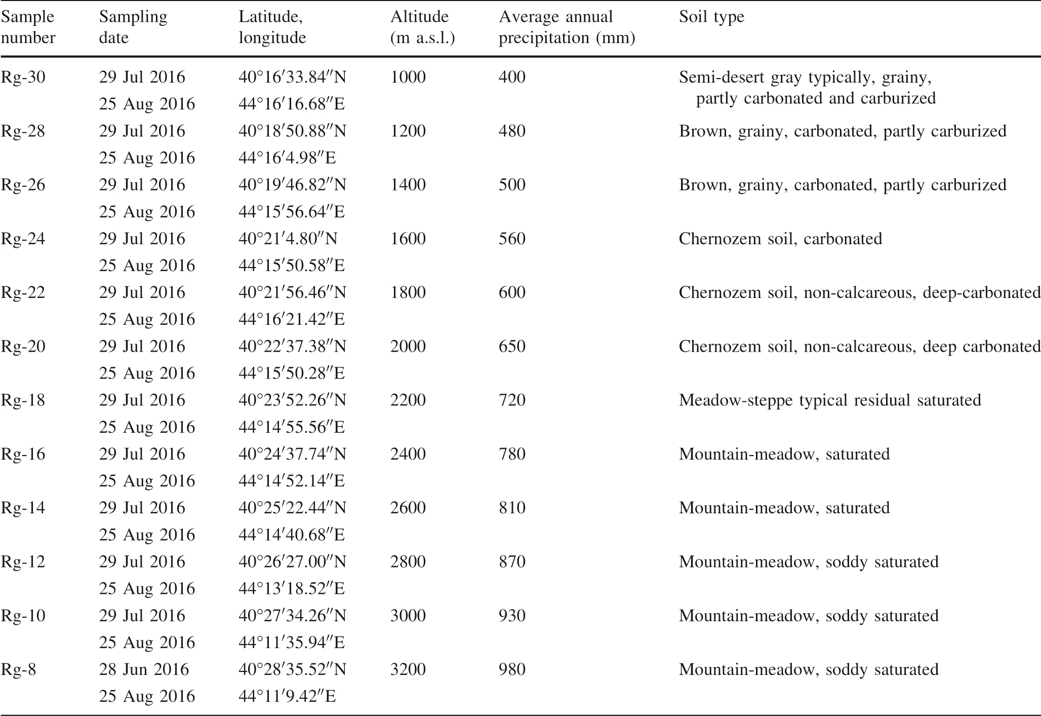
Table 1 Soil sampling sites and soil types
2.4 Assessment of effective dose from exposure to soil contamination from global 137Cs
The slopes of Aragats massif are rather densely populated and alpine and subalpine meadows utilized as seasonal pastures. Here one may enjoy national historic sites of Armenia, recreation zones, and lots of tourist routes running through the region. For this reason, this research included an assessment of potential dose to the population from137Cs.
The effective dose from137Cs deposition over a 50-year long period was calculated by a formula recommended in an IAEA Technical Document (IAEA-TECDOC-1162 2000).

where Eextis the effective dose from deposition for the period of concern (50 years), expressed in mSv; Cg,iis the average deposition (ground) concentration of radionuclide i, expressed in Bq m-2; CFiis a conversion factor—effective dose per unit deposition for radionuclide i(includes external dose and committed effective dose from inhalation due to resuspension of contaminated ground particles for the period of concern), for137Cs equal to 0.13 mSv kBq-1m-2in 50-year period;n is the number of radionuclides.
2.5 Estimation of radiological indices
With the purpose to collate the activity concentration of137Cs and naturally occurring radionuclides in soils radium equivalent activity was calculated using the relation(UNSCEAR 2000):

where CU, CThand CKare the activity concentration in Bq kg-1of238U,232Th, and40K, respectively.
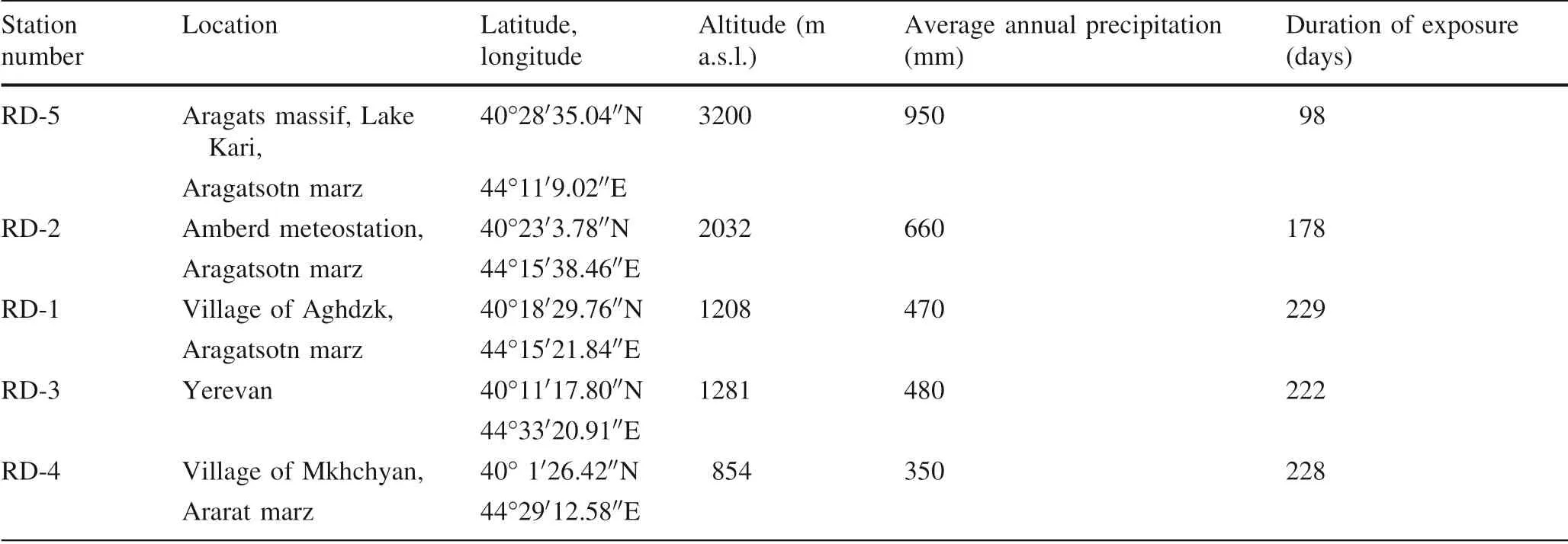
Table 2 Location of dry deposition sampling stations and duration of exposure
In order to assess the potential radiological hazard,external gamma radiation hazard index (Hex) from natural sources of gamma rays in soils was calculated according to UNSCEAR (2000):

External hazard index is a dimensionless parameter; a unit represents hazard posed by activity concentration equal to 370 Bq kg-1238U (or226Ra). In the case of Hex≤1, the external gamma radiation level is considered insignificant.
The annual effective dose equivalent (AEDE) from naturally occurring radionuclides in soils was calculated by using the following equation:

where D is outdoor gamma absorbed dose rate and was calculated from the concentrations of the radionuclides in soil: D=0.462CU+0.604CTh+0.0417CK; DCF is dose conversion factor(0.7 Sv Gy-1),OF is outdoor occupancy factor(0.2),and T is the time(8760 h year-1)(UNSCEAR 2000).
2.6 Statistical analysis
The IBM SPSS software was used for statistical analysis of data. Main descriptive statistics were calculated for each radionuclide activity concentration in soil. For each radionuclide (variable) samples of 1st and the 2nd sampling campaigns (samples) were treated separately, data normality was checked using the Shapiro–Wilk test. Logtransformation of data were used in the case that the sample exhibit no normal distribution.
In order to assess the geochemical variability of radionuclides within sampling sites, correlation analysis was performed. Pearson correlation was applied for correlation analysis of similarly distributed data while distribution free Spearmen rank correlation method was chosen for samples abnormally distributed. Paired sample t test was applied in order to assess the repeatability of sampling campaign for137Cs altitude-dependent distribution revealing.
3 Results and discussion
3.1 Data statistical treatment
The descriptive statistics of activity concentration of137Cs and naturally occurring radionuclides in soils are shown in Tables 3 and 4. The values of skewness and kurtosis calculated for137Cs samples are significantly high (Table 3),which suggests that the data are deviated from a normal distribution. The result of the Shapiro–Wilk test for logtransformed data(p value equal 0.185 and 0.608 for the 1st and the 2nd sampling campaign, respectively) showed that both samples follow a lognormal distribution. Moreover, a significant linear correlation was obtained for two samples(Table 5) and the resulting p value of paired sample t test was 0.65 indicating that two samples of137Cs activity concentration in soil are the representatives of the one lognormal distributed population.
Activity concentration of137Cs in the soil correlates with altitude significantly. Although the amount of precipitation enhances with altitude, no significant correlation was found for137Cs and annual precipitation (Table 5).Such a relationship was reported in many papers(Almgren et al. 2006; Ananyan and Araratian 1990; De Cort et al.1998; Hirose 2000; IAEA 1991, 2015; Le Roux et al.2008).However,the design of this particular study:samplesize, complexity of geological structure, heterogeneity of parent rocks and soil types in the study area,does not allow to evaluate this relationship.
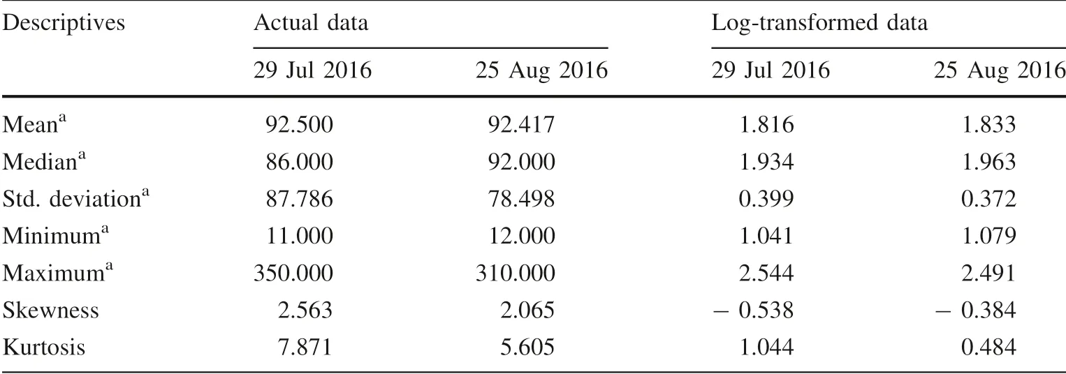
Table 3 Descriptive statistics of actual and log-transformed activity concentration of 137Cs in soil
Results of the Shapiro–Wilk test suggest that238U and samples follow normal distribution (p value equal 0.894 and 0.988 for the 1st and the 2nd sampling campaign respectively) while no distribution pattern was found for232Th and40K, even though low values of skewness and kurtosis for samples of40K suggested certain symmetry of the data (Table 4). The activity of40K in soil estimated in the 1st and 2nd sampling campaign is not significantly correlated. However, the activity decreases slightly as the altitude increases. Thus, a negative non-linear correlation was found between40K activity in soil and the altitude:Spearman’s rho is equal to - 0.622 and - 0.601 at the 0.05 level (2-tailed) for the 1st and the 2nd sampling campaign, respectively (Table 5).
3.2 The activity of 137Cs and naturally occurring radionuclides in soil and dry atmospheric depositions
Activity concentrations and specific activity of137Cs in the studied mountain soils are given in Table 6. The specific activity of137Cs in soils varies within wide limits from 495 to 528 Bq m-2at 1000 m a.s.l. in Ararat Valley to 10,500–11,470 Bq m-2in soils nearby Lake Kari at 3200 m.137Cs activity level in soils of Aragats massif exponentially increases as the absolute height above sea level increases (Fig. 2). Relatively high contents of137Cs detected in Rg-28 and Rg-26 soils(1200 and 1400 m a.s.l.)may presumably be determined by sorption capability of soils (brown, grainy, carbonated, and partly carburized)(Burger and Lichtscheidl 2017). The estimated effective dose for the 50-year period from137Cs accumulated in soil by altitude varies 0.07–1.43 mSv year-1(Fig. 3).
There is a good agreement between the obtained data and the results of another study performed in Ararat Valley(Nalbandyan et al. 2007) and those obtained within the zone monitored by the ANPP (Avagyan et al. 2009;National Report 2012; Pyuskyulyan et al. 2008). Over the last decade(2006–2016),137Cs activity in native landscape soils at 880–1100 m a.s.l. showed variations 300–429 Bq m-2(Fig. 4). Moreover, in several studies aimed at revealing of the distribution pattern of137Cs in mountain regions, a positive correlation between137Cs activity concentration and the altitude was reported(Almgren et al. 2006; Pourcelot et al. 2003; Yordanova et al. 2014). The main factors of cesium-enriched soil formation are wet deposition, mainly heavy rain and snow(Pourcelot et al.2003;Almgren et al. 2006) slope gradient(Nosrati et al. 2015; Bazshoushtari et al. 2016), peculiarities of soil type such as organic matter, pH, erosion rate,etc. (Almgren et al. 2006; Yordanova et al. 2014; Urushadze and Manakhov 2017). For instance, activity concentration of137Cs in different soil types of Georgia(Urushadze and Manakhov 2017)ranged from 4.1 ± 2.0 to 143.9 ± 21.8 Bq kg-1at 0–2500 m a.s.l., indicating altitudinal dependence. Yordanova et al. (2014) reported,despite the fact of significant heterogeneity of137Cs activity concentration in mountainous soils collected from catchment basin of Beli Iskar dam lake,Bulgaria(from 3 to 1700 Bq kg-1at altitudes 1700–2000 m a.s.l.) still has the highest accumulation of137Cs that was detected in mountains comparing to plain(between 30 and 340 m a.s.l.)and hilly (between 560 and 700 m a.s.l.) areas. Positive correlation of137Cs activity in soil layer ‘‘a’’ (0–3 cm) and in the soil core (0–40 cm) with the altitude of the sampling location in Babia Go´ra Mountain’s massif, Poland, was reported by Stobinski et al.(2014).The activity of137Cs in soil reported in the above-mentioned work differs from the results obtained within current study.This can be explained by clear latitudinal zoning of radioactive fallout from nuclear weapons testing on the one hand and heterogenesity of the fallout of137Cs released into the atmosphere after nuclear accidents and incidents, due to air mass circulation and precipitation immediately after cesium release on the other (Mabit et al. 2008).

Table 4 Descriptive statistics of actual activity concentration of naturally occurring radionuclides (238U, 232Th, 40K) in soil
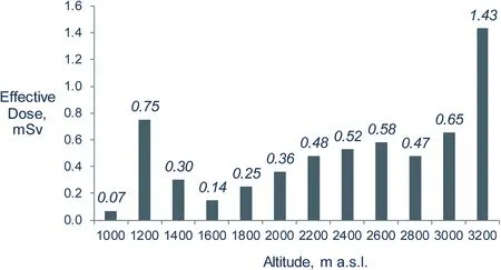
Fig. 3 Effective dose for 50-year period from 137Cs in studied soils by altitude. Mean data for the 1st and 2nd sampling campaigns
Activity concentrations of naturally occurring radionuclide activities in soils measured in the context of this research (Table 7) suggest that238U and232Th exhibit significant geochemical variability within sampling sites and no statistically significant regularities of distribution by altitude. Activity concentration of40K decreased slightly by altitude. However, the geochemical variability was rather high. As mentioned above, the area of Aragats massif is characterized with igneous rocks. Therefore, soil radioactivity conditioned by soil formation and geochemical processes and, as a result, the distribution of naturally occurring radionuclides depends on local geology and not the altitude. On the other hand, soil erosion in mountain area may cause re-distribution of radionuclides,which will result in high geochemical variability within the same sampling site.
Radium equivalent activity in studied soils varied from 128.0 to 189.8 Bq kg-1. The averaged value of 162.2 Bq kg-1(Table 8) is lower compared to the global average value reported by UNSCEAR (2000). Subsequently, the external hazard index did not exceed 1.
Annual effective dose equivalent from naturally occurring radionuclides in soils of Aragats varied from 0.09 to 0.12. The average of 0.09 mSv year-1exceeds the world average value estimated as 0.07 mSv year-1(UNSCEAR 2000). The values of annual effective dose equivalent decreased as altitude increases, which suggests the domination of naturally occurring radionuclides in radiological dose formation by the 3000 m a.s.l.,where settlements and seasonal pastures are situated. The effective dose from137Cs in mountain soil was significantly low as compared to terrestrial natural radiation.
137Cs activity in dry atmospheric depositions varies 1.06–2.37 Bq m-2per quarter (Table 9) and increases as the altitude increases. The correlation coefficient for the five concurrent soil samples and atmospheric deposition is rather high: r = 0.86 at 0.05 level (Fig. 5). The obtained data coincides with the data provided by ANPP.According to the study of ANPP implemented in 2016,137Cs activity in dry atmospheric depositions at a height of 900 m within the environmental impact zone monitored by ANPP constituted 0.8 Bq m-2per quarter, which clearly corresponds to the value obtained within this study.
In Armenia,it is assumable that there are two sources of137Cs in dry atmospheric depositions:(1)the global fallout from nuclear weapon tests that remains to be a significant source of artificial radionuclides in the environment nowadays (Aoyama et al. 2006; Avagyan et al. 2009) and(2) the fallout of137Cs after Chernobyl accident (Ananyan and Araratian 1990; Avagyan et al. 2009; Belyaeva and Pyuskyulyan 2016; National Report 2012; Pyuskyulyan et al. 2008). According to the results of long-term monitoring of the influence of ANPP, the share of ANPP releases is negligibly low as compared to terrestrial radiation and global fallouts(Avagyan et al.2009).The share of137Cs releases from ANPP within a 10-km radius from ANPP makes only 20% as compared to global radioactive fallout (Avagyan et al. 2009; Belyaeva and Pyuskyulyan 2016; Pyuskyulyan et al. 2008). The lack of radio-ecological monitoring system in Armenian high mountains in the 2010s prevents the identification and assessment of the contribution of radionuclides that probably reached Armenia after Fukushima Daiichi accident in 2011. The Fukushima fallout was observed not only in Pacific coastal countries (UNSCEAR 2014) but also in European highlands (Masson et al. 2011). During that period, environmental radiation monitoring was provided only within a 30 km zone around the ANPP. This zone included the site at the foot of Aragats massif up to 1100 m a.s.l. where no enhanced radionuclides were detected in soils or sediments(Belyaeva and Pyuskyulyan 2016; Pyuskyulyan et al.2008).
The determination of altitude-dependent137Cs distribution is the initial stage of radioecological monitoring aimed at revealing the peculiarities of radionuclide migration throughout Armenia. This was the start of a program for a quantitative assessment of transboundary (global) migration of radionuclides. A comprehensive understanding of typical concentrations and migration pathways of radionuclides will make it possible to determine new occurrences of environmental contamination and identify the sources. So, early identification of risk associated withradioecological issues will largely contribute to the development of an early warning system, mitigate risks to the population and environment, increase safety and promote sustainable development of regions.
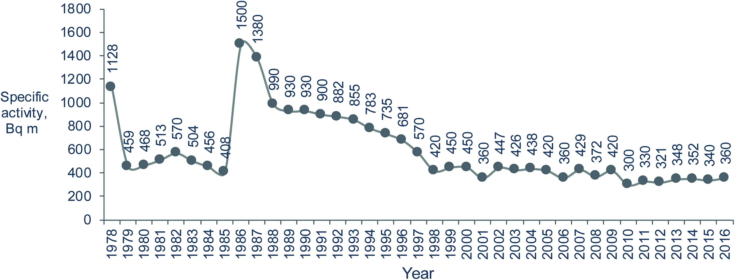
Fig. 4 Specific activity of 137Cs(Bq m-2) in Ararat Valley soils within the zone monitored by the ANPP
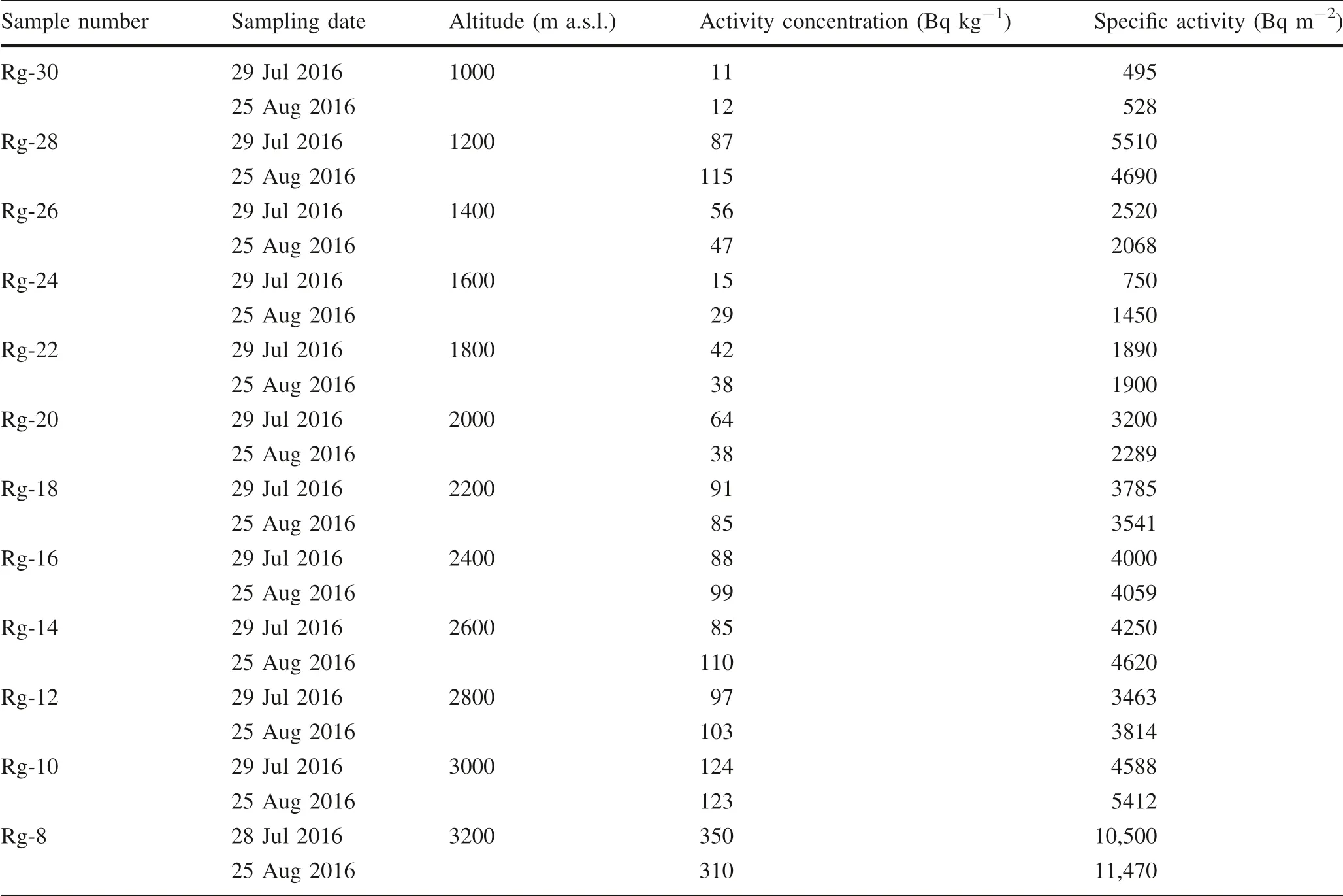
Table 6 Activity concentration (Bq kg-1) and specific activity (Bq m-2) 137Cs in studied mountain soils
4 Conclusions
In 2016, investigations were completed to assess the altitude-dependent distribution of137Cs in soils and dry atmospheric depositions in Aragats massif and Ararat Valley (Armenia). The specific activity of137Cs in soils at 1000 m is 495–528 Bq m-2, and at 3200 m is 10,500–11,470 Bq m-2. Activity concentration of137Cs in soil increases exponentially as the altitude increases.Although the amount of precipitation enhances with altitude, no significant correlation was found between137Cs and the annual precipitation. The effective dose from137Cs-contaminated soils by altitudes over 50-year period varies from 0.07 to 1.43 mSv,which is far lower than a per capita dose limit established in Armenia.
No correlation observed for137Cs, which varies in distribution by altitude, versus naturally occurring radionuclides. Specific activities of137Cs in dry atmospheric depositions varied from 1.06 at 846 m to 2.37 Bq m-2per quarter at 3200 m and increased with altitude.Activities of137Cs in soil and dry atmospheric deposition correlate significantly.
Annual effective dose equivalent from naturally occurring radionuclides in soils of Aragats massif exceeds the world average value for all studied soils. Thus, naturally occurring radionuclides are dominated in radiological dose and dose rate formation in Aragats massif however external radiation hazard index from primordial radionuclides is insignificant.
This new understanding of radionuclide distribution from historic nuclear test and reactor accident fallout serves as essential information that is necessary to detect new inputs to the environment and serves as the basis for an early warning system for radiation safety in Armenia.
AcknowledgementsThis research was implemented in the frames of a Grant No. 15T-1E061 ‘‘Radioecological Monitoring in the Area ofthe Republic of Armenia’’ 2015–2017, under support of State Committee of Science to the Ministry of Education and Science RA.
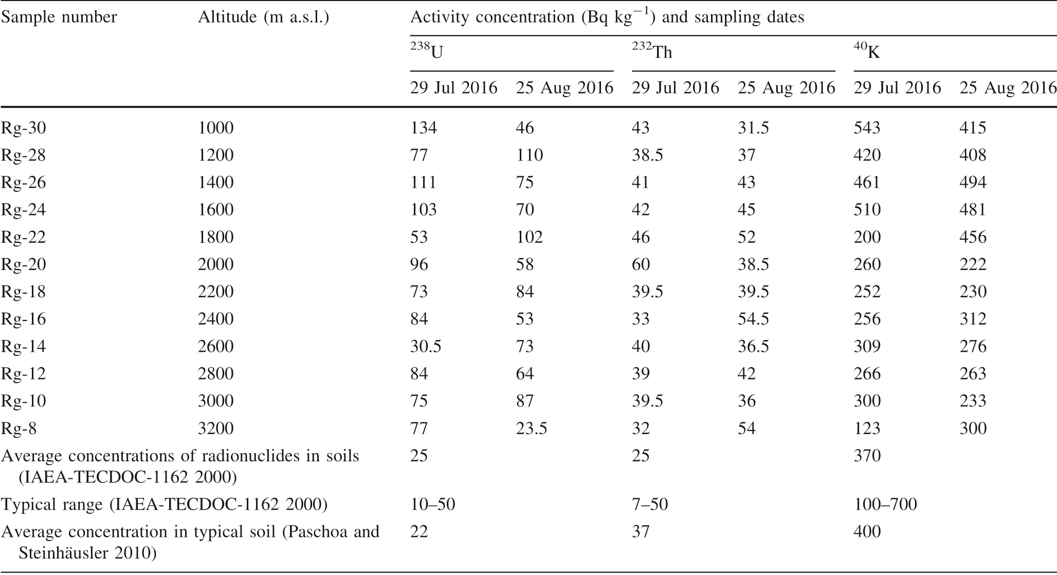
Table 7 Activity concentrations (Bq kg-1) of naturally occurring radionuclides in studied mountain soils
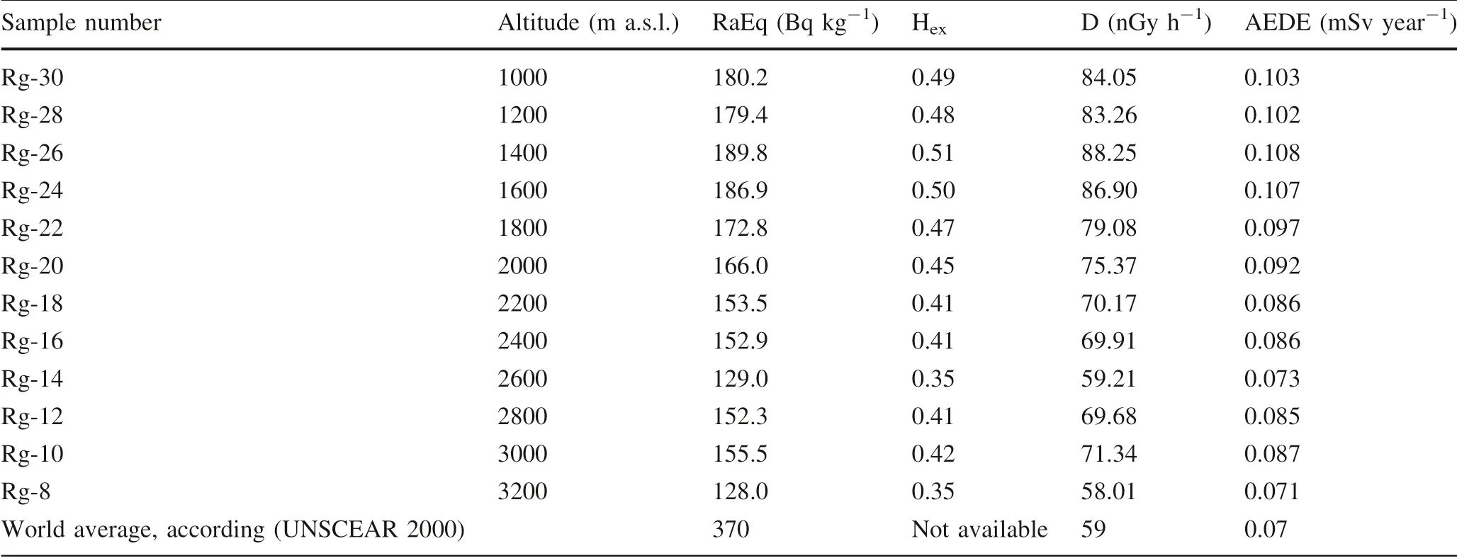
Table 8 Radium equivalent activity,outdoor gamma dose rate in air and annual effective dose equivalent from naturally occurring radionuclides in soils of Aragats massif

Table 9 Specific activity of Cs-137 in dry atmospheric depositions
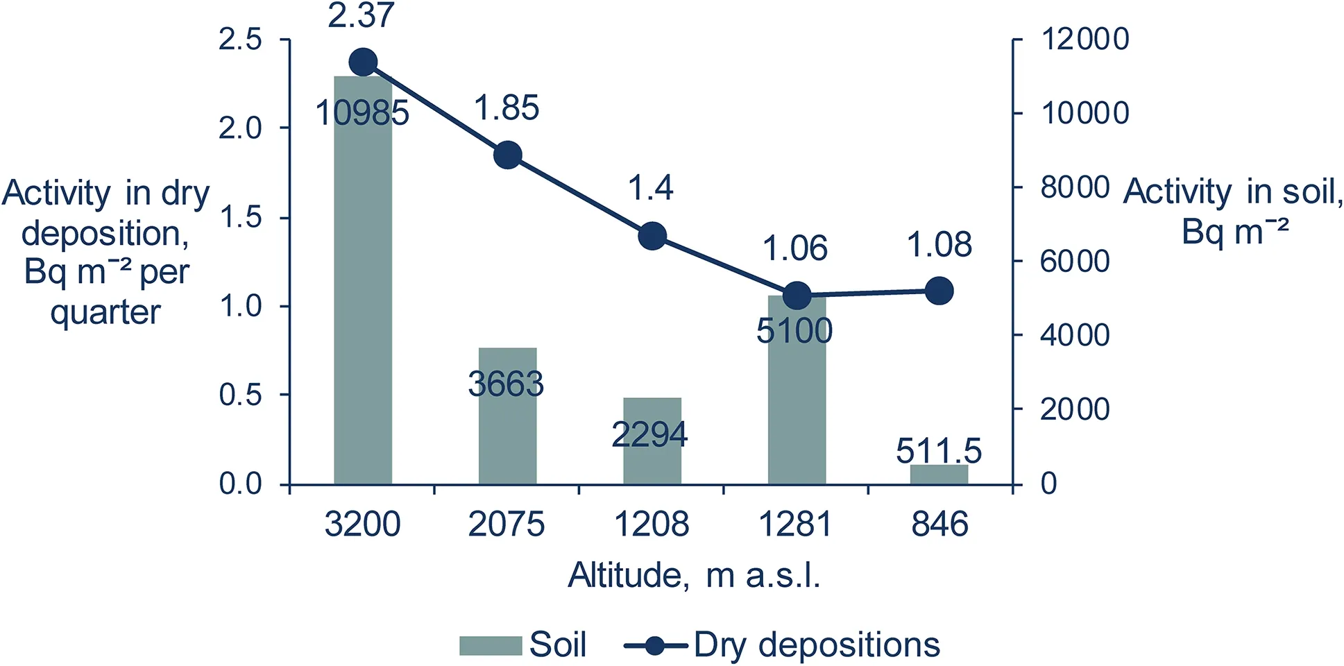
Fig. 5 Specific activity of 137Cs in dry atmospheric depositions(Bq m-2 per quarter) and soils (Bq m-2) from concurrent sampling locations and sampling stations
杂志排行
Acta Geochimica的其它文章
- Chemical structure of the Earth’s mantle defined by fast diffusion elements like helium
- A helium stratified and ingassed lower mantle: resolving the helium paradoxes
- Mechanism of accelerated dissolution of mineral crystals by cavitation erosion
- Zircon chemistry and new laser ablation U-Pb ages for uraniferous granitoids in SW Cameroon
- Zircon U-Pb age and geochemical constraints on the origin and tectonic implication of the Tuotuohe Cenozoic alkaline magmatism in Qinghai-Tibet Plateau
- Evaluation of the potential risks of heavy metal contamination in rice paddy soils around an abandoned Hg mine area in Southwest China
