环境基础设施城市化初探
2019-05-18刘志强朱文一
刘志强 朱文一
环境(Environment)与人类生存关系密切,包括自然环境与社会环境。环境基础设施(Environment Infrastructure)是指为城市环境保护与生态建设提供服务而建设的设施。环境基础设施城市化(Environment Infrastructure Urbanism)是指随着城市发展,环境基础设施的使用现状况发生改变,包括环境基础设施形式的变化和使用功能的转变。环境基础设施包括园林、绿化地与环卫设施3个子类(图1),其中,园林主要是指各类公园,包括植物园、动物园、郊野公园以及雕塑公园等;绿化地主要是指城市中的绿色空间,包括由草坪、林带、行道树、防护绿地、苗圃等组成的城市绿带系统与各种公共绿地;环卫设施是指为提升城市环境卫生服务的基础设施,包括垃圾处理设施、公共厕所与其他市容与环境卫生设施。
与交通基础设施、水利基础设施、能源基础设施相比,环境基础设施的城市化与城市生态建设的关系更加密切,可以说,环境基础设施城市化的过程就是一个城市生态化的过程。因而,与交通基础设施、水利基础设施、能源基础设施相比,设计师在介入环境基础设施城市化的过程中,应当从自然环境切入,其设计过程是对于自然资源的整合与优化。从这个角度来讲,环境基础设施城市化的理想状态是实现“原生态”。随着环境基础设施城市化进程的推进,环境基础设施的“设施”属性将越来越弱,因而,我们又可以说,环境基础设施城市化的过程就是一个去“设施”属性的过程,或者说是一个“自然”化过程。在这个过程中,传统意义上的绿化将逐步走向“荒野”(图2)。“简而言之,荒野和城镇是共生关系,城镇依赖于荒野提供的原材料,而荒野依赖于城镇提供的消费[1]。”这段话揭示了环境基础设施城市化过程中其与自然间的关系,而最终,随着技术与意识的进步与统一,这样的共生关系将走向共融。本文基于此构想,依托传统环境基础设施的分类,结合环境基础设施的发展情况,讨论了目前环境基础设施城市化的情况,探索环境基础设施城市化的可能性。
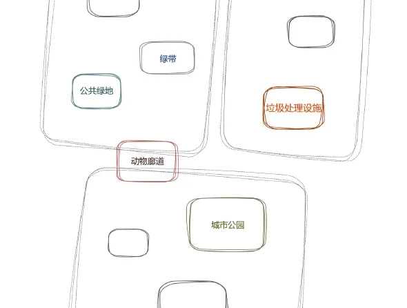
图1 / Figure 1Category of Infrastructural Urbanism of Environment Infrastructure环境基础设施城市化类别来源/Source:作者自绘
城市公园(City Garden)是指将城市基础设施转变功能用作公园,成为城市公园体系的一部分。随着基础设施城市化的进行,基础设施将成为城市公园体系构成的重要来源之一。在此背景下,城市公园的功能定位也将发生变化,在未来很长一段时间内,城市公园与社区的关系将变得更加密切,中心城区的基础设施用地为实现城市公园与社区的整合提供了可能性。这样的城市公园将成为社区活动的场所,提升社区的活力。相较于传统城市公园而言,环境基础设施城市化背景下的城市公园设计在功能上将呈现两个极端,对于特殊群体的设计将趋向高度对象化,即根据某类群体的特点进行定制化设计,这也使得空间将呈现很高的识别性;另一个极端是在进行场地设计时,将最大限度地保留场地的适应性,这样的适应性设计将丰富公园的活动类型,有利于提升城市公园辐射范围内社区的活力。
克莱德沃伦公园(Klyde Warren Park)位于美国达拉斯,建立在得克萨斯州最繁忙的Woodall Rodgers高速路之上,面积为20,000平方米。Woodall Rodgers高速路是横亘在达拉斯市中心、艺术区和北部居民区之间的屏障,它割裂了人口密集的北部社区与达拉斯市中心和北部居民区之间在空间上的联系,而克莱德沃伦公园的建设解决了这个问题,重新恢复了这一地区的连接(图3上)。公园的建设资金来自于联邦、州、市与个人4个不同群体范围,它不仅重新整合了城市面貌,还为周边的博物馆和商业设施提供了一处综合型户外活动场地。克莱德沃伦公园落成后深受周边社区居民的欢迎,它能够获得成功的重要原因之一在于其丰富的活动类型能够满足不同群体的需求。在施工过程中,公园的一侧设置了“食物卡车”来代替正在建设的餐厅为人群提供服务,由于“食物卡车”十分受欢迎,在餐厅落成后,它们得到了保留,并根据卡车的位置重新调整了铺地,使得这里成为一个独立而完整的永久性设施,这方便了通勤的人群,使得公园与周边社区产生联系。公园内还设置有宠物狗公园,这个由土坡结合植物构成的供遛狗者专用的公园同样深受社区居民欢迎,因而管理者将其扩张提上了日程。此外,公园内还设计了儿童活动区,活动区的设计以营造探索感为核心,设置了大大小小符合儿童活动尺寸的土坡和可以钻行的设施(图3下),圆润的造型在最大限度保证儿童安全的同时也使得空间十分具有识别性,活动区还设置有一条毛毛虫式的喷泉,通过喷气装置模拟了一条毛毛虫,作为蝴蝶喷泉的组成部分,它具有“化茧成蝶”的寓意,这个充满趣味性的互动式空间成为公园中人气最高的场所之一。此外,公园中还有一处可同时容纳5,000人的大草坪,草坪具有相当的适应性,它可以成为小型音乐会的举办场地,也可以作为居民周末野餐的场所。公园的一侧通过结合种植的橡树林和树枝形灯架,两侧布置座椅,提供报刊亭和各类棋盘游戏,形成一条休闲内街。克莱德沃伦公园的建设也促进了周边地区的经济发展,使得周边房屋的租金收益得以上涨,不同地区的租金上涨从30%~60%不等,而其旁边的一处未开发土地的价值也在公园建成后上涨到原来的3倍。

图2 / Figure 2荒野Wilderness来源/Source:http://blog.hankchristensen.com/wp-content/uploads/2016/08/gem-lake-emigrantwilderness-124171.jpg
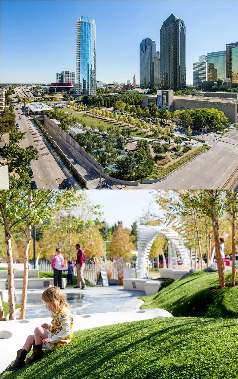
图3 / Figure 3克莱德沃伦公园上:公园与周边环境 / 下:公园儿童活动设施Klyde Warren ParkTop: Contaxt of Klyde Warren Park / Bottom: KlydeWarren Park Children's Activity Facilities来源/Source:(上/Top)https://www.ojb.com/project/klyde-warren-park(下/bottom)https://www.ojb.com/project/klyde-warren-park
动物廊道(Animal Corridor)是指为保护动物迁徙所设计的路上通道。动物廊道可以是动物园的组成部分,也可以是为恢复自然状态下被人工设施割裂而设计的迁徙廊道。之所以将动物廊道作为环境基础设施城市化中重要的一种类型,一方面是因为动物廊道在很多情况下是野生动物园中的重要组成部分,另一方面则是因为其形式与内容上呈现出自然原生态,符合环境基础设施城市化的定义。
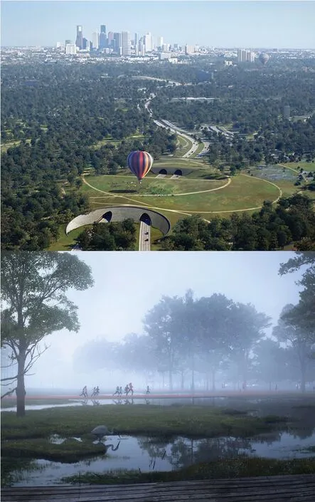
图4 / Figure 4休斯顿纪念公园上:公园的连接 / 下:公园跑步中心与雨水滞留区Houston's Memorial ParkTop: Connetcion of Houston's Memorial Park /Bottom: Running Center and Rainwater Retention Area of Houston's Memorial Park来源/Source:http://www.nbwla.com/projects/park/memorial-park
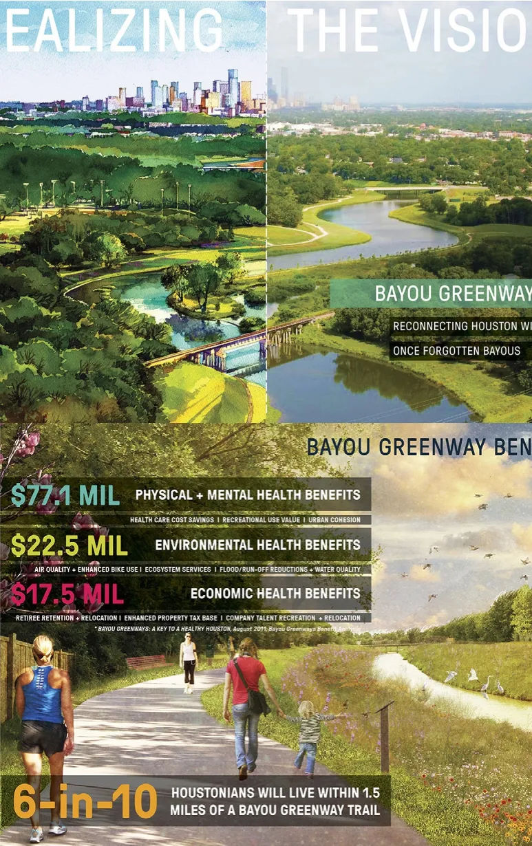
图5 / Figure 5休斯顿河湾绿道系统规划上:愿景与现实 / 下:规划的经济价值Bayou Greenways Master PlanTop: Realizing and Vision of Bayou Greenways/Bottom: The Value of Bayou Greenways Master Plan来源/Source:http://www.swagroup.com/projects/bayou_greenways/
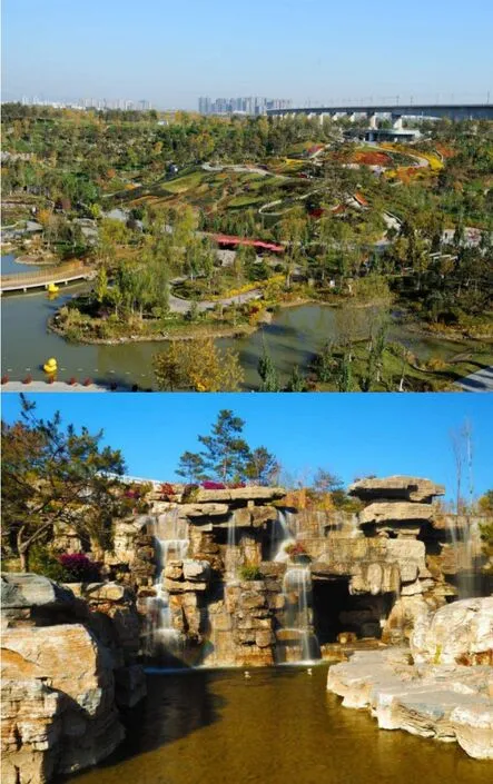
图6 / Figure 6北京园博园公园上:公园与周边环境 / 下:公园深坑景观Beijing Garden Expo ParkTop: Contaxt of Beijing Garden Expo Park / Bottom:Beijing Garden Expo Park Deep Pit来源/Source:http://www.huitu.com/photo/show/20131125/221646546200.html
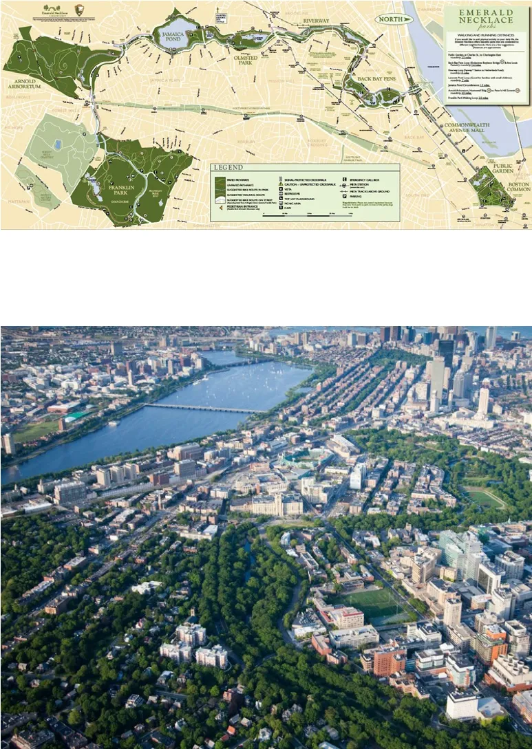
图7 / Figure 7波士顿翡翠项链公园上:公园平面图 / 下:公园与城市关系Emerald NecklaceTop: Master Plan / Bottom: Necklace in the City来源/Source:(上/top)http://www.greeningthegray.org/wp-content/uploads/2013/04/emerald-necklace.jpg(下/bottom)http://www.touristsbook.com/boston/fi les/2014/11/Emerald-Necklace-Boston-1000x600.jpg
休斯顿纪念公园位于610环路内侧,南侧以布法罗河为边界,向东距离休斯顿市中心6.5km。这里曾经是一战时期士兵的训练场,战后为了纪念因战争而战死的士兵建立此公园。然而,由于道路和分布在自然保护区中的休闲活动空间长期割裂纪念公园,使得公园的生态系统与空间质量每况愈下。为了改善这样的情况,Nelson Byrd Woltz Landscape Architects事务所对公园进行了重新规划,新规划中的一个重点便是规划了多条重新连接被道路分割的公园的动物廊道(图4上)。公园的新规划在对该地深入调研的基础上,确立了通过进行多样化植物种植恢复场地原生生态的设计理念。这与人们普遍希望恢复之前松林密布的想法不同,因为经过调研证实,松树作为外来物种,并不适合在此进行种植,相较于单一树种组成的松林,多样化的生物组成将更有助于抵御未来的水旱灾害,保持场地的生态稳定性。设计人员将公园空间分为3种类型,一部分通过具体实施和管理实现生态的多样性,另一部分通过维持与保护,最后一部分则通过新建与从地区迁出实现。动物廊道的建立对于生态多样性的实现至关重要,空间上的联通使得自然状态下物种的传播具有了可能性,从而助力恢复原生生态目标的实现。而相关科学数据与资料研究表明,在过去的数百年间,南侧公园自然与人类占领的空间此消彼长,两者你退我进、你进我退,相互影响,始终未达到稳定的状态,而这意味着动物廊道的建设与生态多样性的实现潜力极大。作为动物廊道的延续,沿布法罗河形成了休斯顿公园跑步中心与雨水滞留区(图4下),这为人们日常与公园发生关系提供了空间上的支撑,也可以看出设计者对于人与自然关系的思考。
绿带(Greenbelt)是指一个带形或线性的绿色开敞空间,绿带不仅作为一种应对城市无限蔓延的手段,同时为居民提供活动和游憩的生态圈,在保持城市与乡村可持续发展方面起到重要作用[2]。本文的绿带对应基础设施中的林带、防护绿地、行道树等类型,绿带可以由这些元素构成,但单一的元素未必一定会形成绿带。与霍华德的绿带概念相比,基础设施对应的绿带现阶段更加关注其连接性,如何将现有的线性环境基础设施片段连接成为绿带,连接绿地空间,构建城市绿地系统并提升沿线社区的生态性是现阶段环境基础设施城市化关注的重点。
休斯顿河湾绿道系统规划是建立在Arthur Comey1931年的报告《休斯顿,实验性城市发展计划》的基础上于近年形成的一条长度近500km的线性公园系统(图5上)。新的公园系统将该地区范围内10条水道重新连接,惠及的人口数量达到近200万人。根据德克萨斯大学John Crompton教授的研究估算,休斯顿河湾绿道系统绿道规划每年将带来的包括经济、环境与身体及精神健康方面的多项收益超过1.17亿美元(图5下)。休斯顿虽然具有公园空间与步行系统,但由于市内缺乏明确分区,导致了未能在这些节点空间之间形成连接空间,因而使得这些公园与步行系统十分分散,这也直接导致了全美第四大城市的休斯顿城市公园系统面积常年位于全国城市的下游水平。河湾绿道项目是改善此种状况的一个契机,它将使得休斯顿城市公园间得以建立连接并为城市提供数量可观的休闲空间,整合现有公共资源,为周边社区居民提供宝贵的生态化公共活动空间。
垃圾处理设施(Garbage Disposal Facilities)是指将工业、生活生产、医疗卫生等产生的垃圾集中进行回收处理的场所及其设施。垃圾处理设施中最为重要的一种类型是城市垃圾处理场,常见的垃圾处理方式包括卫生填埋法、堆肥法和直接焚烧法等。填埋区易产生沼气、含毒污水, 对空气、土壤和地下、地表水产生污染[3]。城市垃圾处理设施中填埋场占据了重要的地位,数量众多。所以,在环境基础设施城市化过程中,如何对待这些垃圾处理场成为设计师面临的重要课题。由于这些垃圾场本身面临严重的土壤污染,因而,在对其进行城市化设计的过程中应当更多地考虑其土壤自身的净化。就目前来看,采用相关生态技术,将其用作城市生态公园,通过土壤中微生物的降解作用,恢复被污染的土壤是普遍采用的方式。
北京园博园公园(图6上)是由原本被称为“永定河大沙坑”的北京著名建筑垃圾场改造而成,园博园陆地面积267公顷,加上246公顷的园博湖,总面积513公顷[4]。原本臭名昭著的垃圾场,因为常年填埋建筑垃圾,形成了30米的深坑(图6下),通过巧妙的景观设计,利用此高差建成了下沉式花木景区锦绣谷,形成瀑布跌水景观[5]。另外,采用水源净化工程,引入生物浮床、表流湿地、替流湿地等,建设生态湿地,净化了永定河的水质,也使得土壤环境得以改善[5]。园内的5个展园:传统展园、现代展园、创意展园、湿地展园和国际展园经过精心的景观与建筑设计,这样的设计极大提升了原本地处城乡交界带位置的景观水平。北京园博园的建设改善了生态环境,将原本无人问津的垃圾场变成了城市绿肺[5]。
公共绿地(Green Area)是指城市中适用于居民游憩休闲的成片绿色空间,如果说绿带最大的形态特征是其线性空间形态,那么,公共绿地则呈现面状形态,它与绿带共同构成城市公共绿色空间系统。
作为景观设计的奠基人之一奥姆斯特德的代表作品,波士顿翡翠项链公园体系形成了园中有城、城中有园的效果(图7上),这座城市公园使得波士顿成为了一座公园城市(图7下)。公园利用河流等自然要素作为其边界,加上16km长的绿道系统,形成了450公顷的城市公共绿地,绿地系统由9个城市公园组成,每个公园的主题各异,包括城市公园、公共花园、沼泽地等不同形式,公园与城市生活相融,为居民提供连续的健身和休闲娱乐场所。公园因地制宜,利用地形的起伏形成具有适应性的层次丰富的开敞城市绿地,结合天鹅湖等水面,开发水上活动,形成丰富的城市活动。
环境基础设施的城市化过程就是城市的生态化过程,这个过程要求我们从根本上改变过去对环境基础设施的认识。环境基础设施设计与建设的出发点与落脚点要始终以自然作为参考,最大限度地恢复自然的原生生态,同时,作为基础设施,它又要为满足人们的基本需求服务,而这实际上反映了“天人合一”的思想。环境基础设施的城市化将成为城市与自然相结合的切入点,优秀的环境基础设施设计将为提升社区活力与增强社区生态性作出贡献。
A Study on the Infrastructural Urbanism of Environment Infrastructure
LIU Zhiqiang
Environment is closely related to human existence,including the natural environment and the social environment. Environment infrastructure refers to facilities built to provide services for urban environmental protection and ecological construction.Environment infrastructural urbanism refers to changes in the use of environment infrastructure as the city develops, including changes in the form of environment infrastructure and changes in the use of functions. The environment infrastructure is consisted of three sub-categories, including gardens, green areas and sanitation facilities. Among them, gardens mainly refer to various types of parks, including botanical gardens, zoos, country parks and sculpture parks. Green areas mainly refer to green spaces in cities, including urban green belt system consisting of lawns, forest belts, street trees, protective green spaces, nurseries, etc. and various public green spaces. Sanitation facilities refer to the infrastructure for improving urban environmental sanitation services,including garbage disposal facilities, toilets and other cityscapes and environments health facilities.
Compared with transportation infrastructure, water infrastructure and energy infrastructure, the urbanization of environment infrastructure is more closely related to urban ecological construction. It can be said that the process of urbanization of environment infrastructure is a process of urban ecologicalization.Therefore, compared with transportation infrastructure, water infrastructure and energy infrastructure,designers should start from the natural environment in the process of intervening in the urbanization of environment infrastructure. The design process is the integration and optimization of natural resources. From this perspective, the ideal state of urbanization of environment infrastructure is to achieve “original ecology”. With the advancement of environment infrastructure urbanization, the characteristics of facilities of environment infrastructure will be reduced. Therefore, we can say that the process of urbanization of environment infrastructure is a process of “de-facilities”, or It is said to be a“natural” process. In this process, the greening in the traditional sense will gradually move toward the“wilderness” (Figure 2). “In short, wilderness and towns are symbiotic relationships, towns depend on the raw materials provided by the wilderness and wilderness depends on the consumption provided by the towns.” This passage reveals the relationship between environment infrastructure and nature in the process of environment infrastructural urbanism. In the end, with the advancement and unity of technology and consciousness, such symbiotic relationship will move toward communion. Based on the concept above and the classification of traditional environment infrastructure, combined with the development of environment infrastructure, this paper discusses the current urbanization of environment infrastructure and explores the possibility of environment infrastructural urbanism.
City Garden refers to the use of urban infrastructure transformation functions as a park and as part of the urban park system. As infrastructure urbanization progresses, infrastructure will become an important source of city garden systems. In this context,the functional orientation of city garden will also change. In the future, the relationship between city garden and communities will become closer. The infrastructure land in the central urban area will provide the integration of city garden and communities.Klyde Warren Park is a good example of this kind of infrastructural urbansim.The Woodall Rodgers Highway is a barrier between the heart of Dallas, the arts district and the northern neighborhood, which separates the spatial connection between the densely populated northern community, the downtown and northern residential areas of Dallas. The construction of the Clyde Warren Park solved this problem and restored the connection in this area (Figure 3).
Animal corridor refers to the roadway designed to protect animal migration. The animal corridor may be part of the zoo, or it may be a migration corridor designed to restore the natural state of being separated by artificial facilities. Houston's Memorial Park is an excellent example of this kind of infrastructural urbansim. It used to be a training ground for soldiers of World War I. After the war, it was built to commemorate the soldiers who died in war.However, due to the long-term separation of the roads and leisure activities in the nature reserve, the park's ecosystem and space quality are deteriorating. To improve this situation, Nelson Byrd Woltz Landscape Architects re-planned the park and one of the key points in the new plan was to plan a number of animal corridors that reconnected the parks that were segmented by the road (Figure 4).
Greenbelt refers to a strip-shaped or linear green open space. The green belt not only serves as a way to cope with the in fi nite spread of the city, but also provides residents with an ecological circle of activities, and maintaining the sustainable development of the city and the countryside. The green belt of this paper corresponds to the forest belt, protective green space and street tree. The green belt can be composed of these elements, but a single element does not necessarily form a green belt. Compared with Howard's green belt concept, the green belt corresponding to the infrastructure is more concerned about its connectivity and connection of the existing linear environment infrastructure segments.It also concerns about connecting the green space to build the urban green space system and enhance the community along the line. Ecology is the focus of urbanization of environment infrastructure. Bayou Greenways Master Plan is a good example of this kind of infrastructural urbanism. It allows the connection between Houston city garden and provides a significant amount of leisure space for the city,integrating existing public resources and providing valuable ecological public space for residents of the surrounding communities.
Garbage disposal facilities are places where facilities such as industrial, domestic production, medical care and the like are collected and disposed of. Beijing Garden Expo Park (Figure 6) was transformed from the famous Beijing construction waste dump,which was originally called “Yongding River Dasha Pit”. The park has improved the ecological environment and it is turned from a garbage dump that was originally unattended into a city green lung.
The green area refers to the green space in the city that is suitable for residents to enjoy leisure and recreation. As one of the founders of landscape design,Olmsted's representative work, the Emerald Necklace formed the effect of having a city in the park and a garden in the city (Figure 7). This green area made Boston a garden city. It consists of 9 urban parks with different themes, which use the ups and downs of the terrain to form an open urban green space with a rich and adaptable level to form a rich urban activity.
The urbanization process of environment infrastructure is the ecological process of the city, which requires us to fundamentally change the past understanding of environment infrastructure.
