基于无人机图像分析的树木胸径预测
2017-11-17刘文萍仲亭玉宋以宁
刘文萍,仲亭玉,宋以宁
基于无人机图像分析的树木胸径预测
刘文萍,仲亭玉,宋以宁
(北京林业大学信息学院,北京 100083)
树木胸径是林木资产评估中的重要参数,该文利用图像分析技术预测树木胸径可为资产评估提供参考。以银杏和法国梧桐为试验树种,通过拟合无人机正射图像中的单株树木树冠面积与胸径的关系预测树木胸径值。首先利用二型模糊聚类方法对无人机采集的纯林样地正射图像中的单株树冠进行分割,获取树冠像素面积,然后利用地面参照物计算出树冠的实际面积,并与测量的胸径值进行拟合,得出树冠面积与胸径的函数关系,林区中其他树木胸径值可基于该函数关系和其树冠面积计算得出。试验结果显示无人机正射图像中的银杏及法桐树冠面积与胸径均呈对数关系,且该文计算所得的银杏1.2 m处的胸径与实际胸径之间的平均误差约为0.31 cm,法桐1 m处的胸径与实际胸径之间的平均误差为0.27 cm,均在行业允许的1 cm误差范围内,该文提出的基于无人机正射图像分析技术预测树木胸径较为准确,可为中小尺度林地资产评估提供参考。
无人机;图像分析;预测;Type-2 FCM;单株树冠提取;胸径预测;林地资产评估
0 引 言
中国国土资源丰富林地广袤,对林地资源进行合理估价有助于摸清家底,实现林地资源的资产化管理[1-2],同时对提高林地资源综合利用效率,保护和合理利用林地资源也将起到积极的推动作用。林地资产评估的研究重点主要是成熟林木或人工种植林木的资产评估,林木的树冠和胸径是重要的测量因子[3]。现阶段对于成熟林木或人工种植林木的评估还主要依赖于实地考察测量和工作人员的估测,因天气或环境恶劣使得测量工作遇到很多困难,且若测量出现误差还可能造成评估结果出现偏差,此外,人工评估林地资源消耗大量的人力物力,因此迫切需要探索新技术进行林地资产评估工作。无人机(unmanned aerial vehicle,UAV)近年来逐渐在各行业得到了广泛应用[4-7],通过无人机搭载数码相机航拍的影像具有高清晰、大比例尺、小面幅、实时性强的优点,能快速获取多空间的尺度的地面观测数据。张园等证明了无人机遥感在森林资源调查中是可行的[8],无人机航片分辨率高,有利于监测森林蓄积量[9]。随着无人机应用的推广,许多遥感应用都涉及到树冠面积的评估[10],Kang等[11]使用J阈值分割方法识别无人机近红外图像中的树冠区域;Díazvarela等[12]研究证明遥感估算与实地测量的树冠参数有较高的一致性。
林业专家的前期研究表明:在胸径的建模中冠径、树冠面积和树高是最常用的变量[13-17],且胸径与冠径具有最佳的对应关系,胸径越大,冠径越大[18-21]。戴福等[22]认为林木的冠径与胸径呈明显的直线关系。许道林[23]拟合了林木冠径与胸径的回归关系,并将林分平均胸径代入模型估算出了林分单位面积理论密度。胡云云等[24]以天然云冷杉针阔混交林为研究对象,建立了7个主要树种的胸径与树龄的方程,可以提高当地的生长与收获模型的精度。
本文以山东省临沂市郯城地区人工林为试验样地,选取可根据胸径(diameter of tree at breast height,DTBH)评估树木价值的银杏()和法国梧桐()作为研究树种,提出了一种利用无人机图像分析技术的树木胸径预测方法。该方法首先利用无人机采集大面积纯林林地正射图像,然后基于二型模糊聚类算法提取图像中的树冠,并根据参照物计算树冠面积,同时结合地面实测的小面积样地中拟合样本树胸径值,得到树冠面积与胸径的相关函数,林地中其他树木的胸径值可基于该相关函数和其树冠面积计算得出。
1 基于图像分析的胸径预测流程
本文旨在探索由无人机正射可见光图像获得的树冠面积与树木胸径之间的相关性。首先利用无人机搭载的摄像机拍摄林地的正射图像并进行预处理,然后基于二型模糊聚类算法(type-2 fuzzy c-means,Type-2 FCM)对图像中的单株树冠进行分割获得树冠像素面积(pixel area of tree crown,PATC),并结合参照物实际面积与其在图像中的像素面积之比,可求取树冠面积(actual area of tree crown,AATC)。试验选取样地中70%有效样本树作为拟合样本树,可拟合出树冠面积与地面测量胸径(measured diameter of tree at breast height,MDTBH)的相关函数曲线,基于该相关函数和其余30%样本树(验证样本树)的树冠面积计算胸径值(calculated diameter of tree at breast height,CDTBH),并与实际测量的胸径值进行比较,计算胸径误差以验证该方法的准确性。流程图如图1所示。
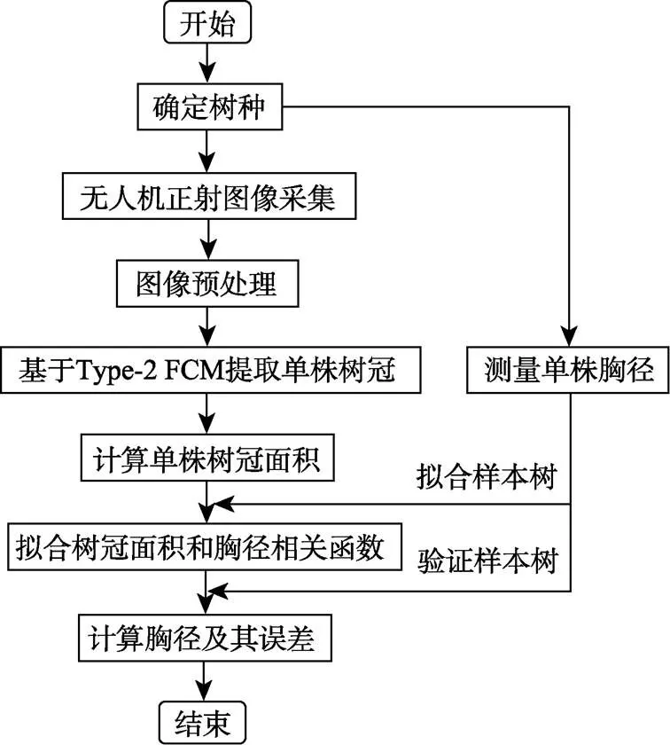
图1 基于无人机图像分析的树木胸径预测流程图
2 试验树种选择及无人机正射图像采集
银杏木材优质,极具药用、保健、生态和观赏价值[25],1.2 m处的胸径为其价值评估的重要参数。法桐树形雄伟端庄,是优良的行道树种,广泛应用于城市绿化[26],其1 m处的胸径为价值评估的重要参数。课题组在山东省临沂市郯城地区选取了树龄为5 a的银杏及2~3 a法桐作为试验树种,在林木叶片生长较为茂盛的5月和9月对分布在郯城不同地区的共6块银杏样地和2块法桐样地进行了无人机正射图像采集,无人机飞行高度为15~100 m,同时对样地中所有树木进行编号,并测量银杏1.2 m(法桐1.0 m)处的胸径值。
考虑到不同树种或相同树种不同树龄的单株树冠面积与其胸径的相关函数曲线是不同的,课题组采用分样地建模。因此从相同树龄及树种林区中选取20 m´20 m大小的样地,测量该样地中所有树木的胸径,拟合出树冠面积与胸径的相关关系函数,利用该相关函数即可计算林区其他树木的胸径值。
前期试验结果表明:当飞行高度高于60 m,图像分割准确性变差,而树冠像素面积提取不准确会影响后续的拟合关系;当飞行高度低于25 m时,图像不能显示整块样地,因此无人机最佳飞行高度范围为25~60 m,且对同一片纯林进行图像采集时保持固定的飞行高度。
多旋翼无人机相对固定翼无人机具有悬停能力,可使用GPS 导航,且起降条件要求较低[27],因此本文使用的无人机为8旋翼航拍机,详细参数如表1所示,无人机搭载相机型号为Sony A7RII,镜头规格为35 mm,图像分辨率为3 984´2 656像素,采集的银杏及法桐样地部分正射图像见图2。

表1 8旋翼航拍无人机参数

注:图a~c中白旗实际面积为2.88 m×1.92 m,图d中白旗实际面积为0.3 m× 0.4 m。
3 基于Type-2 FCM算法的树冠提取
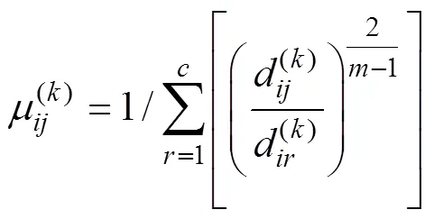
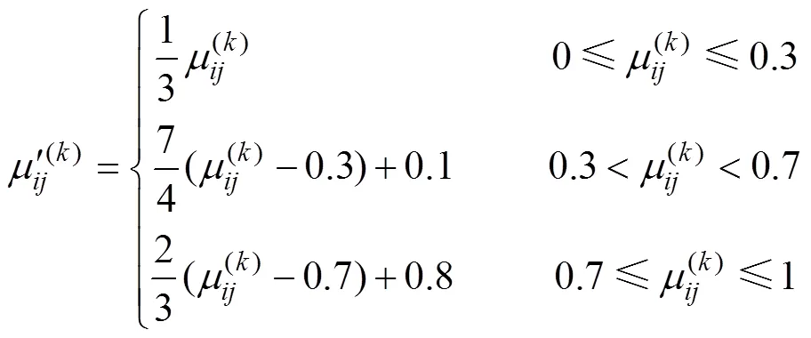
3.1 Type-2 FCM算法

2)求取隶属度矩阵[28]
3)迭代求取新的聚类中心[29]

4)判断聚类结束条件
3.2 树冠提取结果
基于该算法对银杏及法桐样地无人机正射图像进行分割,结果如图3所示,图4为提取出的树冠区域,便于后续的拟合过程描述,对各单株树进行编号。
3.3 算法分割评价与树冠面积计算
3.3.1 算法分割评价


3.3.2 树冠面积计算
图4提取的单株树冠区域的像素总数即为树冠像素面积PATC。考虑到无人机正射图像中的树冠像素面积与无人机飞行高度有关,因此课题组采用参照物计算出树冠的实际面积,用该面积拟合树冠面积与胸径的相关函数,避免不同飞行高度对拟合关系的影响。
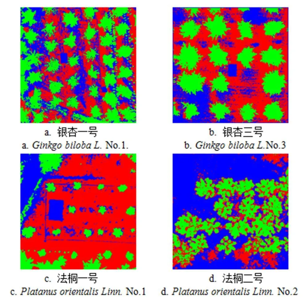
图3 基于2型模糊聚类的图像分割结果
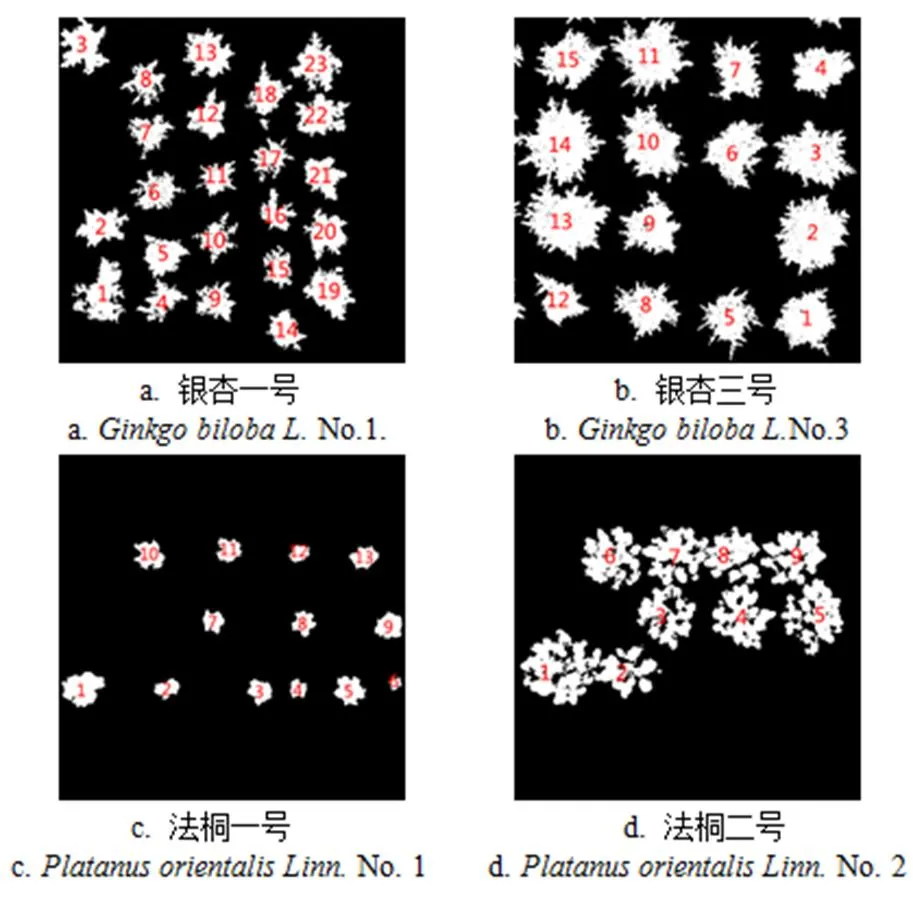
图4 树冠提取结果

表2 树冠图像错分率
试验采用2.88 m´1.92 m和0.3 m´0.4 m的白色旗子作为参照物,图2a~d中白旗像素面积分别为1 233、1 860、5 136和72,树冠面积AATC如下

4 树冠面积及胸径的相关函数拟合及验证
4.1 树冠面积及胸径相关函数拟合
课题组从各样地有效样本树(图像中树冠区域提取完整的树木)中选取70%做为拟合样本树,其余为验证样本树。银杏一号有效样本树23株(见图4a),No.1-No.17为拟合样本树;银杏三号有效样本树15株(见图4b),No.1-No.11为拟合样本;法桐一号有效样本树13株(见图4c),No. 1-No. 10为拟合样本;法桐二号有效样本树9株(见图4d),No.1-No.6为拟合样本。各样地树冠面积与胸径的拟合曲线如图5所示。

图5 各样地树冠面积与胸径拟合曲线
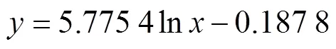
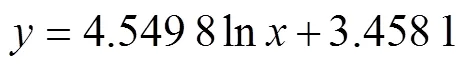
银杏一号、三号样地及法桐一号、二号样地拟合出的公式分别为式(7)~(10):


4.2 相关函数验证
利用图中参照物实际面积与其像素面积比值及各样地验证样本树的树冠像素面积可求出其树冠面积,并分别代入式(7)~(10)计算出胸径值,然后与实际测量的胸径值进行比较,结果如表3所示。试验结果表明:银杏一号、三号样地及法桐一号、二号样地验证样本树的计算胸径与测量胸径的平均误差分别为0.24、0.31、0.04和0.49 cm,且每株树木的计算胸径误差在林业允许的1 cm误差范围内。
课题组采用同样的方法对共8块银杏及法桐样地进行了试验,由于篇幅有限,本文仅选取银杏和法桐各2块样地进行详细介绍。对所有样地的试验进行统计,结果为6块银杏样地单株树木胸径平均误差为0.31 cm,2块法桐样地的树木胸径平均误差为0.27 cm。

表3 各样地测量胸径与计算胸径的比较
5 结 论
本文以银杏和法桐为试验树种,提出了基于无人机正射图像分析的胸径预测方法,该方法首先利用图像分割算法提取出无人机正射图像中单株树木的树冠区域,从而得到银杏和法桐的树冠像素面积,同时利用地面参照物得出图像像素面积和实际面积的比值,进而计算出树木的树冠面积,然后利用树冠面积及实际测量的胸径值,拟合出树冠面积与胸径的相关关系函数,利用该函数可根据无人机图像中的其他树冠像素面积计算出该树木的胸径值。试验结果表明:无人机正射图像中的银杏及法桐的树冠面积与胸径呈对数关系,且根据无人机图像分析技术计算所得的胸径与测量的实际胸径之间的误差在允许的1 cm误差范围内。
本文利用无人机对大面积林区进行航拍,仅测量 20 m´20 m样地内的树木胸径,即可较为准确地预测出林区其他树木的胸径值。由于无人机操控简单、系统维护便利、飞行范围广,可深入林区进行图像拍摄,避免了人工测量因天气或环境因素可能遇到的困难,同时为中小尺度林地资产评估提供了参考,也为资产评估的智能化提供了新的思路。
本文仅探索了利用无人机及图像分析技术对人工纯林林区中树木胸径测量的方法,对于有多种树种的林区,要先对树种进行图像识别,这将是下一步要研究的问题。
[1] 王强. 森林资源资产评估方法探讨[D]. 北京:对外经济贸易大学,2006.
Wang Qiang. Discussion on the Method of Forest Resource Assets Valuation[D]. Beijing: University of International Business and Economics, 2006. (in Chinese with English abstract)
[2] 胡瑶瑶. 帽儿山林场林地评估方法与应用研究[D]. 哈尔滨:东北林业大学,2010. Hu Yaoyao. Research on the Forest Land Evaluation Methods and Application of Maoershan Forest Farm[D]. Harbin: Northeast Forestry University, 2010. (in Chinese with English abstract)
[3] 吴明钦,孙玉军,郭孝玉,等. 长白落叶松树冠体积和表面积模型[J]. 东北林业大学学报,2014,42(5):1-5. Wu Mingqin, Sun Yujun, Guo Xiaoyu, et al. Predictive models of crown volume and crown surface area for korean larch[J]. Journal of Northeast Forestry University, 2014, 42(5): 1-5. (in Chinese with English abstract)
[4] 王利民,刘佳,杨玲波,等. 基于无人机影像的农情遥感监测应用[J]. 农业工程学报,2013,29(18):136-145. Wang Limin, Liu Jia, Yang Lingbo, et al. Applications of unmanned aerial vehicle images on agricultural remote sensing monitoring[J]. Transactions of the Chinese Society of Agricultural Engineering (Transactions of the CSAE), 2013, 29(18): 136-145. (in Chinese with English abstract)
[5] Pena J M, Torres Sanchez J, Serrano Perez A, et al. Quantifying efficacy and limits of unmanned aerial vehicle (UAV) technology for weed seedling detection as affected by sensor resolution[J]. Sensors, 2015, 15(3): 5609-5626.
[6] Hou Peng, Xu Jingwen, Zhao Junfang, et al. A novel model based on LBP and meanshift for UAV image segmentation [C]//Applied Mechanics and Materials, 2014, 701-702: 270-273.
[7] Pajares G. Overview and current status of remote sensing applications based on unmanned aerial vehicles (UAVs) [J]. Photogrammetric Engineering & Remote Sensing, 2015, 81(4): 281-329.
[8] 张园,陶萍,梁世祥,等. 无人机遥感在森林资源调查中的应用[J]. 西南林业大学学报,2011,31(3):49-53. Zhang Yuan, Tao Ping, Liang Shixiang, et al. Research on application of UAV RS techniques in forest inventories[J]. Journal of Southwest Forestry University, 2011, 31(3): 49-53. (in Chinese with English abstract)
[9] 付卓新,姚锐.浅谈森林资源调查中无人机遥感的应用[J]. 南方农业,2015,9(36):246-248. Fu Zhuoxin, Yao Rui. Introduction to the application of UAV remote sensing in forest resources inventory[J]. Source China Agriculture, 2015, 9(36): 246-248. (in Chinese with English abstract)
[10] Panagiotidis D, Abdollahnejad A, Chiteculo V. Determining tree height and crown diameter from high-resolution UAV imagery[J]. International Journal of Remote Sensing, 2017, 38(8/9/10): 2392-2410.
[11] Kang Jun, Wang Li, Chen Fang, et al. Identifying tree crown areas in undulating eucalyptus plantations using JSEG multi- scale segmentation and unmanned aerial vehicle near-infrared imagery[J]. International Journal of Remote Sensing, 2017, 38(8/9/10): 2296-2312.
[12] Díazvarela R, Raul D L R, Leon L, et al. High-resolution airborne uav imagery to assess olive tree crown parameters using 3D photo reconstruction: application in breeding trials [J]. Remote Sensing, 2015, 7(4): 4213-4232.
[13] 刘莉娟. 银杏人工林生长因子分析及经营密度研究[D]. 泰安:山东农业大学,2014. Liu Lijuan. Study on Influences on Ginkgo Biloba L Artificial Forest Growth Factor Analysis and the Management Density[D]. Taian: Shandong Agricultural University, 2014. (in Chinese with English abstract)
[14] Kalliovirta J, Tokola T. Functions for estimating stem diameter and tree age using tree height, crown width and existing stand database information[J]. Silva Fennica, 2005, 39(2): 227-248.
[15] Hall R J, Morton R T, Nesby R N. A comparison of existing models for DBH estimation from large-scale photos[J]. Forestry Chronicle, 1989, 65(2): 114-120.
[16] Gonzalez-Benecke C A , Gezan S A, Samuelson L J, et al. Estimating pinus palustris tree diameter and stem volume from tree height, crown area and stand-level parameters[J]. Journal of Forestry Research, 2014, 25(1): 43-52.
[17] Peper P J, Mcpherson E G, Mori S M. Equations for predicting diameter, height, crown width, and leaf area of San Joaquin Valley street trees[J]. Journal of Arboriculture, 2001, 27(6): 306-317.
[18] Sprinz P T, Burkhart H E. Relationships between tree crown, stem, and stand characteristics in unthinned loblolly pine plantations[J]. Canadian Journal of Forest Research, 2009, 17(6): 534-538.
[19] Smith W R, Jr R M F, Murphy P A, et al.Crown and basal area relationships of open-grown southern pines for modeling competition and growth[J]. Canadian Journal of Forest Research, 2011, 22(3): 341-347.
[20] Gill S J, Biging G S, Murphy E C. Modeling conifer tree crown radius and estimating canopy cover[J]. Forest Ecology & Management, 2000, 126(3): 405-416.
[21] Gering L R, May D M. The relationship of diameter at breast height and crown diameter for four species groups in Hardin County, Tennessee[J]. Southern Journal of Applied Forestry, 1995, 19(4): 177-181.
[22] 戴福,李凤日,贾炜玮,等. 帽儿山天然次生林10种主要阔叶树冠径与胸径关系研究[J]. 植物研究,2009,29(5):597-602. Dai Fu, Li Fengri, Jia Weiwei, et al. Research crown diameter and diameter at breast height relations of ten kinds of major natural secondary broad-leaved tree in Maoershan[J]. Bulletin of Botanical Research, 2009, 29(5): 597-602. (in Chinese with English abstract)
[23] 许道林. 杉木冠径与胸径关系模型及其应用研究[J]. 安徽林业科技,2013,39(3):27-28,34. Xu Daolin. Relational model of the crown diameter and DBH of Cunninghamia Lanceolata and its application[J]. Anhui Forestry Science and Technology, 2013, 39(3): 27-28, 34. (in Chinese with English abstract)
[24] 胡云云,亢新刚,赵俊卉. 长白山地区天然林林木年龄与胸径的变动关系[J]. 东北林业大学学报,2009,37(11):38-42. Hu Yunyun, Kang Xingang, Zhao Junhui. Variable relationship between tree age and diameter at breast height for natural forests in Changbai mountains[J]. Journal of Northeast Forestry University, 2009, 37(11): 38-42. (in Chinese with English abstract)
[25] 李佳毅,毛立宝,高英凯,等. 不同处理对银杏种子发芽率和成苗率的影响[J]. 吉林农业科技学院学报,2015,24(4):5-7. Li Jiayi, Mao Libao, Gao Yingkai, et al. Effects of different treatments on the germination rate and seedling rate of Ginkgo Biloba seeds[J]. Journal of Jilin Agriculture Science and Technology University. 2015, 24(4): 5-7. (in Chinese with English abstract)
[26] 雷威. 法桐常见问题的浅析[J]. 低碳世界,2015,5(1): 5-6.
[27] 刘建刚,赵春江,杨贵军,等. 无人机遥感解析田间作物表型信息研究进展[J]. 农业工程学报,2016,32(24): 98-106. Liu Jiangang, Zhao Chunjiang, Yang Guijun, et al. Review of field-based phenotyping by unmanned aerial vehicle remote sensing platform[J]. Transactions of the Chinese Society of Agricultural Engineering (Transactions of the CSAE), 2016, 32(24): 98-106. (in Chinese with English abstract)
[28] Bezdek J C, Ehrlich R, Full W. FCM: the fuzzy c-means clustering algorithm[J]. Computers & Geosciences, 1984, 10(2-3): 191-203.
[29] Zhou Wanhui, Liu Wenping. An adaptive type-2 Fuzzy
based algorithm for remotely-sensed image segmentation[J]. Information-An International Interdisciplinary Journal. 2010, 13(3): 551-556.
[30] 费运巧,刘文萍,骆有庆,等. 森林病虫害监测中的无人机图像分割算法比较[J]. 计算机工程与应用,2017,53(8):216-223. Fei Yunqiao, Liu Wenping, Luo Youqing, et al. Comparison of algorithms for unmanned aerial vehicle image segmentation in monitoring forest diseases and insect pests[J]. Computer Engineering and Applications, 2017, 53(8): 216-223. (in Chinese with English abstract)
刘文萍,仲亭玉,宋以宁. 基于无人机图像分析的树木胸径预测[J]. 农业工程学报,2017,33(21):99-104. doi:10.11975/j.issn.1002-6819.2017.21.012 http://www.tcsae.org
Liu Wenping, Zhong Tingyu, Song Yining. Prediction of trees diameter at breast height based on unmanned aerial vehicle image analysis[J]. Transactions of the Chinese Society of Agricultural Engineering (Transactions of the CSAE), 2017, 33(21): 99-104. (in Chinese with English abstract) doi:10.11975/j.issn.1002-6819.2017.21.012 http://www.tcsae.org
Prediction of trees diameter at breast height based on unmanned aerial vehicle image analysis
Liu Wenping, Zhong Tingyu, Song Yining
(100083,)
The diameter of tree at breast height (DTBH) is an important parameter in the evaluation of forestry assets. The traditional method of obtaining the DTBH requires the field survey by the forest workers. To explore the feasibility of the image analysis technique in the evaluation of forestry assets, this article proposes a new approach to predict the DTBH based on the remote sensing imaging technology of the unmanned aerial vehicle (UAV). Tree species used in our experiments include. and. which are from Tancheng District, Linyi City, Shandong Province, China. In the past few years, many studies have shown a high correlation between the DTBH and the crown diameter of tree. This paper explores the correlation between the tree crown region in the image and estimated DTBH. First, the tree crowns in the image are segmented using a Type-2 fuzzy c-means algorithm. Then, the actual area of tree crown (AATC) is calculated from the segmented image. Finally, the correlation between the AATC and measured DTBH can be established. The detail steps of this method are described as follows: 1) The individual tree crown is segmented from the ortho images taken by the UAV using a Type-2 fuzzy c-means algorithm in order to obtain the pixel area (pixel number) of tree crown (PATC) in the image. 2) A white flag with the size of 2.88 m × 1.92 m or 30 cm × 40 cm is used in our study. The ratio of the pixel area in ortho image to the actual area of the flag is calculated. Based on this ratio and the segmented PATC, the AATC is uniform for different flight height. 3) Multiple trees are chosen as training samples, and their measured DTBH is used to derive the correlation function between the AATC and DTBH. 4) The above correlation function is used to calculate the DTBH of the other trees for the validation, and the estimated DTBH and actually measured DTBH are compared to obtain the DTBH error. All of them are less than 1 cm which is the forestry standard. In this study, we model a small area of the forest. The reason to choose a small area is that a huge forest with different landscapes or tree ages will have an impact on deriving a precise correlation function. Hence, a small forest area of 20 m × 20 m is selected as a sample site to establish the correlation function between the tree crown area and the measured DTBH by using multiple tree samples. The DTBH in the other areas of the forest with the same tree species can then be predicted according to this correlation function. Experimental results demonstrate that the proposed method is feasible and effective. Based on our preliminary experiments, the average error between the actually measured and calculated DTBH of. with 1.2 m height is 0.31 cm, and 0.27 cm for. with 1 m height. Both errors are less than 1 cm which is acceptable by the forestry standard. This automatic measurement method has the advantages of simplicity, high efficiency, and low cost. The proposed method can be generalized to other species in the forestry. At the same time, this new method provides an intelligent exploration method and informative way for the forest asset evaluation.
unmanned aerial vehicles; image analysis; prediction; Type-2 FCM; crown area extraction; diameter of tree at breast height prediction; forestry assets evaluation
10.11975/j.issn.1002-6819.2017.21.012
TP391.41
A
1002-6819(2017)-21-0099-06
2017-04-11
2017-08-10
中央高校基本科研业务费专项资金(No.2015ZCQ—XX)
刘文萍,女,河北保定人,教授,博士,博士生导师,主要研究方向为数字图像处理与模式识别。Email:wendyl@vip.163.com