芝加哥滨河步道扩建
2017-05-12Sasaki事务所RossBarney建筑事务所
Sasaki 事务所Ross Barney 建筑事务所
Sasaki, Ross Barney Architects
作品
芝加哥滨河步道扩建
Chicago Riverwalk Expansion
Sasaki 事务所Ross Barney 建筑事务所
Sasaki, Ross Barney Architects

1 总平面图Site plan

2 六个街区与六个愿景Six blocks with six visions
芝加哥河主干河道有着悠久且丰富的历史,它在很多方面映射了芝加哥城市的发展。芝加哥河以前是一条蜿蜒的沼泽溪流,后来被硬化改造为工程河道以支持城市向工业型的转换。1900年,为了改善公共卫生状况,城市将河流主干与南侧分支水流方向倒转。在此之后,此条河道声名鹊起。建筑师、城市设计师丹尼尔·伯纳姆提出了滨河散步道和瓦克道高架桥的新愿景。近30年来,河道扮演的角色随着芝加哥滨河项目进行了又一次的转换——重拾芝加哥河的城市生态与休闲效益。
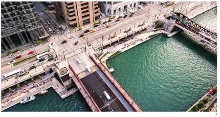
3 穿越城市的芝加哥河The Chicago River

4 滨水空间使得城市生活更加丰富多彩New connections enrich and diversify life along the river
十年前,由于河流的重度污染,进行垂钓、游泳等休闲活动几乎是遥不可及的愿望,但是这个愿景却在今天成为了现实。在水质方面的最新进展以及沿河公共空间使用的提升都体现了滨河生活的发展,与水岸建立了新的连接。
为了响应这些号召,芝加哥交通部开始实施滨河步道项目,用新空间充实系统各个部分,例如退伍军人纪念广场与沃巴什广场。随着户外活动的兴起以及水质的提升,滨水生活开始迅速繁荣起来。
2012年,Sasaki事务所与罗斯巴尼建筑事务所、阿尔弗雷德本纳什工程公司以及一个较大的技术顾问团队合作,任务是为芝加哥州街与湖街之间的六个街区创造新的景象。在先前河流研究的基础上,团队提出的芝加哥滨河概念规划为湖泊与城市步行系统,以及河流在城市中的支流之间提供了最关键的连接。但此任务在技术上面临极大挑战,设计团队需要在7.6m宽的建成区内扩展步行空间,同时与街区间一系列穿过桥下的区域协调。除此之外,设计还需要适应河流每年的洪水涨落,竖向高度差近2m。

5 干净的水质提升了滨河空间活力Improved water quality revitalized the riverfront
一个由设计师、工程师、建造人员与城市行政人员组成的团队在面临着的征求许可和施工建设的巨大挑战下,共同努力,将滨水步行体验带入人们的生活。Sasaki与芝加哥交通部、美国陆军工程兵团和美国河岸管理处合作,在7.6m宽现存的河岸创造绵延数里的连续的景观。
设计着重要求沿岸的步行结构足以承载大型的驳船所带来的压力,这为设计师带来巨大挑战。为了满足要求,团队设计制作了混凝土沉箱,放入河床,为可能的冲击提供了充分的加固。独特的场地同样也为施工团队带来了许多挑战。实际上,施工已经在芝加哥河的驳船上持续开展了。
设计团队为此线性公园提供了新的思路,将这些挑战转化为机遇。一改以建筑为导向的充满直角拐弯的步道,将步道视为一个相对独立的系统,通过自身形态的变化,促进一系列与河道相连的新功能之间的联系。
新的连接使得滨河生活更加丰富多彩,基于不同河道的类型,每个街区呈现了不同的形态,形成了不同的景观项目。他们通过扩大沿河岸的步行空间和为每个街区构建了明显的特征,创造了一种动态的活动体验,使滨河步道被称之为连续的“城市客厅”。Sasaki董事、项目首席设计师、美国风景园林师协会会员(ASLA)吉娜·福特(Gina Ford)谈及此项目时这样说到:“这里的每个空间都被滨河生活赋予了新的能量与活力,这对我们来说非常重要,同时这里有一连串的元素一起沿着这个连续的线性空间流动。”
6 个滨水步道空间
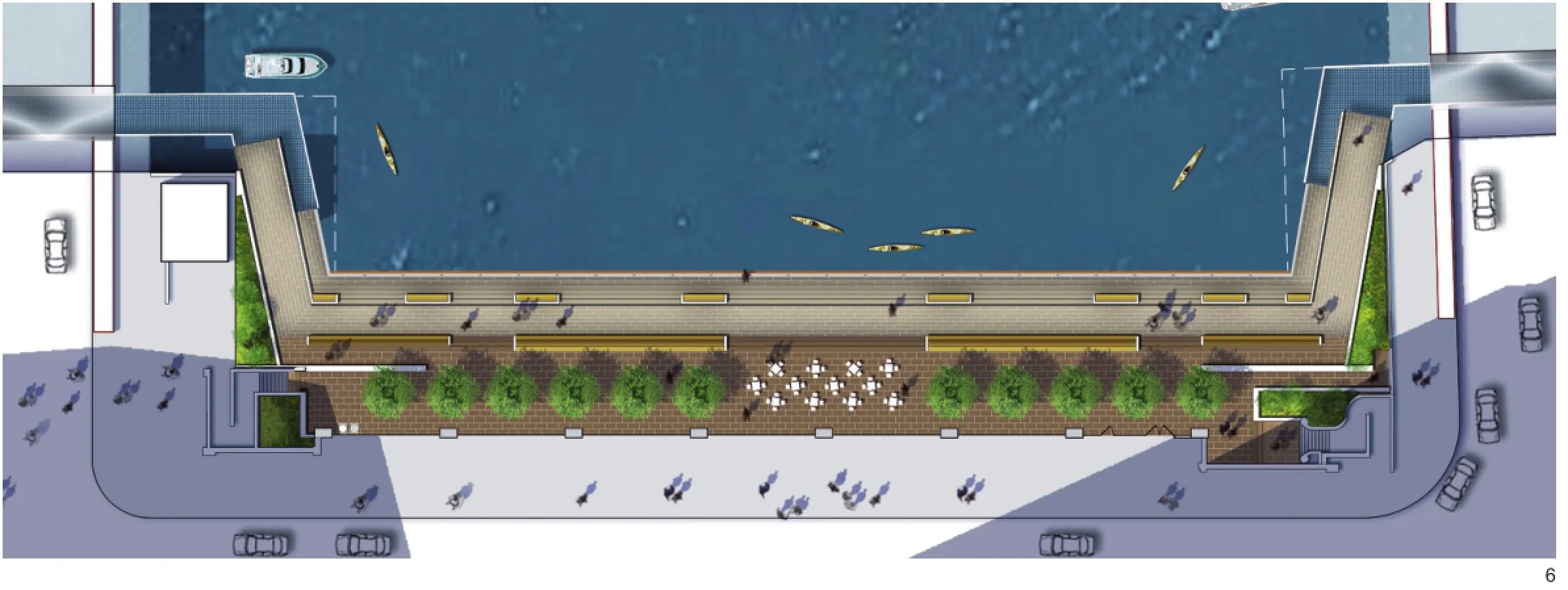
码头广场:餐厅与露天座椅使人们可以观赏河流上的动态场景,包括驳船航行、消防部门巡逻、水上巴士、观光船等。
小河湾:一个可作为零售的拱廊,拾级而下可以到达一个宽阔的城市广场,继续往下是一个低层码头。拱廊为码头创造了一个步行尺度的空间,为使用者提供了休憩场所与便利设施。小海湾通过创造娱乐活动的方式为水体排放提供了一种途径。
河滨剧场:雕塑般的阶梯连接了上瓦克和河滨,为人们到达河滨提供了步行的联系,周边的树木提供绿色与遮荫。
水广场:一个互动旱喷装置被周边的台阶所围绕,同时可作为停坐区域。新的连接空间位于上瓦克步行道之下,水广场为儿童和家庭提供一个参与滨水活动的良好契机。
6 码头广场The Marina Plaza

7 独立的滨河步道系统An independent path system

8 近两米的高差The design accommodates annual flood dynamics of seven vertical feet
码头:一系列的码头和浮岛湿地花园为人们了解河流生态提供了互动学习的环境,包括垂钓和本土植物认知。水下设施为繁殖的鱼群提供了重要的饱腹之物与栖身之所,以确保水下的生物多样性与水上相比并不逊色。
河堤:结合种植的缓坡坡道,将行人带到湖街上的上瓦克区域。
作为一个新的步行连接体系,概念性规划框架为公园游客提供了不间断的步行体验。每个类型的空间具有不同的功能与形态,可以提供滨河的多样体验,从餐饮、大规模公众活动到全新的划艇项目。同时,设计材料与细节在整个项目范围内形成视觉上的统一。例如,铺装与现存纹理形成鲜明对比;精致的琢石沿典雅而具艺术气息的瓦克高架道路与桥屋建筑铺展开,而低层空间与钢筋外露的桥梁下方则由表面粗糙的预制板环绕。
滨水步道同时在可达性上进行了创新设计,以此确保公共空间对每一个使用者都发挥最大的效应。“在滨水步道上,我们希望创造一个停留与眺望芝加哥美好景色的空间,”福特说,“同时我们追求可达性与陪伴休憩作为体验的一部分。”
例如,码头广场用长椅划分出多种空间,并增加了轮椅与婴儿车的可通行性。滨河步道上设计了许多小空间,展示当地文化与游览建议。Sasaki的设计师研究了轮椅与长椅使用者的最适空间深度,使他们可以面对面、肩并肩,同时也研究了小空间的宽度确保轮椅使用者可以坐在人群的中间,而非边缘。

9 小河湾The Cove

10 全新划艇项目场地New amenities for human-powered craft

11 精致的琢石与铺装The refined cut stone and pavement

12 水广场The Water Plaza

13 全新划艇项目场地New amenities for human-powered craft
另外,小河湾利用高高低低的地形来连接各种预制的座椅元素,被设计师和施工者称为“河岸石”、“豆子”或“枕头”。这种石材不规则的特性将4个场地(两上两下)的陪伴座椅相互统一——但是都位于中央,而非边缘。
公众对芝加哥滨河步道的评论与反响十分积极,同时这个城市已经开始将芝加哥河当作它的“第二个河滨”。在2015年建筑记录评论对于此项目描述的第二段中,建筑评论家布莱尔·卡明(Blair Kamin)称赞滨河步道是芝加哥作为“地位日益升高的景观设计师将旧时城市边缘地区成功转化为城市活动中心”的“迄今为止最杰出、最成功的案例”。他同时认为滨河步道将城市空间定义为“连续性与多样性的完美融合和现代与过去的交汇点”。
其中,位于州街与拉萨尔街之间的三个空间于2015年5月建成并开放。另外三个空间的施工于2015年夏季开始,于2016年10月完成。
(编辑/刘昱霏)

14 码头The Jetty

15 一系列的码头A series of piers

16 可供停坐的观景空间Visitors can sit and enjoy the amazing views
项目区位:芝加哥,伊利诺伊州
客户名称:芝加哥市交通部
完成日期:二期2015年5月开放;三期2016年10月开放
面积:二期,0.6hm2/3个街区
三期,0.8hm2/3个街区
领域:规划设计、城市设计、建筑、景观设计、土木工程、平面设计
团队:Sasaki 事务所,Ross Barney 建筑事务所
图片提供:图1、2、6、9、12、14、17©Sasaki ;图3~5、7、8、 10、11、13、15、16、20、22、24、25、26©Christian Philips;图18、19、21、23©Kate Joyce
翻译:李雯
校对:王晞月

17 河滨剧场The River Theater

18 可供停坐的观景空间The place to sit and enjoy the amazing views
The main branch of the Chicago River has a long and storied history that in many ways mirrors the development of Chicago itself. Once a meandering marshy stream, the river quickly became an engineered channel to support the industrial transformation of the city. Following the famed reversal of the river, in which the city reversed the flow of the Main Branch and South Branch to improve sanitation, architect and urban planner Daniel Burnham introduced a new civic vision of riverside promenades with the addition of the Wacker Drive Viaduct. For the last 30 years, the role of the river has evolved once again with the Chicago Riverwalk project—an initiative to reclaim the Chicago River for the ecological and recreational benefit of the city.
The goal of embracing the river as a fishable and swimmable recreational amenity seemed impossible even a decade ago, given the river's high levels of pollution. But today that vision is becoming a reality. Recent improvements in river water quality and the increased intensity of public recreational use signal growing life along the river, and demand new connections with the water's edge. Heeding this call, the Chicago Department of Transportation began implementing the Riverwalk, completing portions of the system that include very successful new spaces, like the Veteran's Memorial Plaza and Wabash Plaza. With the growth of outdoor activity and the improvement of water quality, life along the waterfront is beginning to flourish.
In 2012, Sasaki, Ross Barney Architects,Alfred Benesch Engineers, and a broader technical consultant team was tasked with creating a vision for the six blocks between State Street and Lake Street. Building off previous studies of the river, the team's Chicago Riverwalk Concept Plan provides the last critical link between the lake, the city's pedestrian circulation, and the river's urban branches. The task at hand was technically challenging. The design team, for instance, needed to work within a tight permitmandated 25-foot-wide build-out area to expand the pedestrian program spaces and negotiate a series of under-bridge connections between blocks. Further, the design had to account for the river's annual flood dynamics of nearly seven vertical feet.
A team of architects, engineers, builders, and city officials worked side by side to bring the Riverwalk to life, facing considerable permitting and construction challenges. Sasaki worked in conjunction with the Chicago Department of Transportation, the Army Corps of Engineers, and the U.S. Coast Guard to secure approval to build out 25 feet from the existing shoreline in order to create the Riverwalk's mile-long continuous walkway. In particular, the requirement that pedestrian structures along the river be able to withstand the impact of the largest barge that travels the Chicago River posed a challenge for designers. In response to this requirement, the team engineered concrete-topped cassions that,driven into the river bed, provide sufficient reinforcement against possible impacts. The unusual site also posed access challenges for construction teams. In fact, construction has continually been carried out from barges on the Chicago River.

20 统一的设计材料与细节表现出视觉上的连贯性Design materials, details, and repeated forms provide visual cohesion

21 可供轮椅使用的观景空间Wheelchair accessible space
Turning these challenges into opportunities, the team imagined new ways of thinking about this linear park. Rather than an architecturally-driven path comprosed of 90-degree turns, the team reconceived the path as a more independent system—one that, through changes in its shape and form, would drive a series of new programmatic connections to the river. Withnew connections that enrich and diversify life along the river, each block takes on the form and program of a different river-based typology. Dubbed rooms, they expand the walkable area along the river banks, and create a distinct identity for each block that, taken all together, creates a dynamic experience. Sasaki Principal, Gina Ford, ASLA, the lead designer for the Sasaki team, says of the project, "it was important to us that each space have an energy and excitement inspired by the life of the river, but also that there are elements of continuity as one moves along its edge.”

22 活力十足的滨河夜景Evening view
The following are the six rooms of the Riverwalk.
The Marina Plaza: Restaurants and outdoor seating provide views of vibrant life on the water, including passing barges, fire department patrols, water taxis, and sightseeing boats.
The Cove: A retail arcade steps down to a wide urban plaza and then down again to a low level dock, creating a space for humanpowered craft to dock—and for users to find places for rest and amenity. The Cove provides an outlet for physical connections to the water through recreation.
The River Theater: A sculptural staircase linking Upper Wacker and the Riverwalk offers pedestrian connectivity to the water's edge, while trees provide greenery and shade.
The Water Plaza: This block contains an interactive zero-depth fountain with surrounding stairways designed to double as seating areas and new concession space tucked below the sidewalk of Upper Wacker Drive.The Water Plaza offers an opportunity for children and families to engage with water at the river's edge.

23 嵌在台阶上的灯带Strip lights mounted with stairs
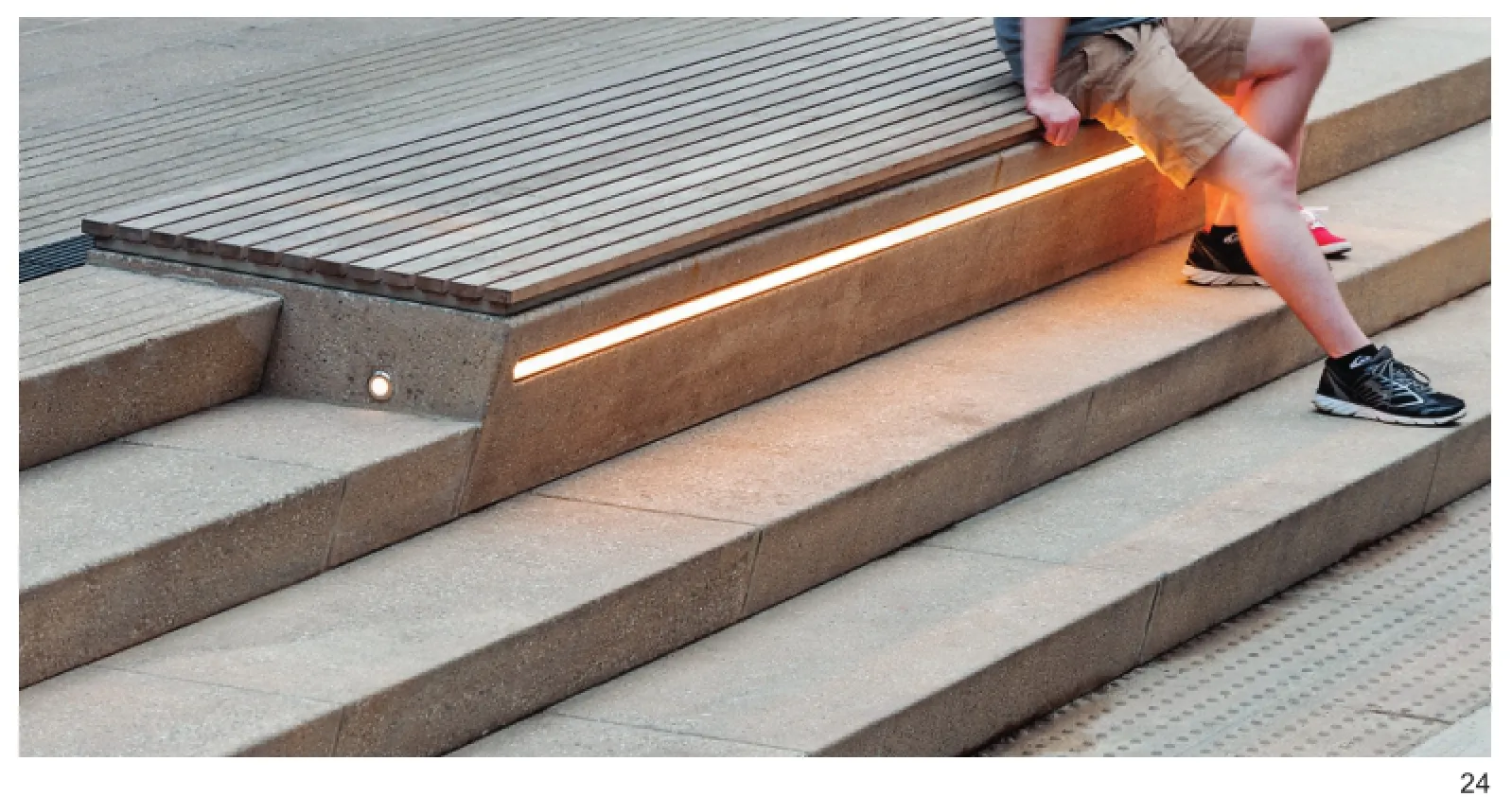
24 嵌在台阶上的灯带Strip lights mounted with stairs
The Jetty: A series of piers and floating wetland gardens offer an interactive learning environment about the ecology of the river, including opportunities for fishing and identifying native plants. Underwater amenities for a burgeoning fish population provide critical shelter, food, and cover, ensuring as much life below the water's surface as above.
The Boardwalk: A mildly sloping ramp,interspersed with plantings, brings pedestrians from the water level to the street level of Upper Wacker at Lake Street.
As a new connected path system, the concept plan's framework provides both continuity and variety for a park visitor. The distinct programs and forms of each typological space allow for diverse experiences on the river ranging from dining opportunities to expansive public event programming to new amenities for human-powered craft. At the same time, design materials and details provide visual cohesion along the entire length of the project. Paving, for instance, mirrors the contrasts of the existing context: a refined cut stone follows the elegant Beaux-Arts Wacker Viaduct and Bridgehouse architecture, while a more rugged precast plank flanks the lower elevations and underside of the exposed steel bridges.
The Riverwalk also features innovative designs in accessibility, which ensures public space is public for all of its users. “Along the Riverwalk, we imagined a place to sit and enjoy the amazing views of the amazing life on the Chicago River,” says Ford, “and we wanted accessibility and companion seating to be an integrated part of the experience.”

25 活力十足的滨河夜景Evening view
The Marina, for example, has pockets of space in multiple places along the length of the bench where wheelchairs and strollers can perch. As designed, the Riverwalk has more such spaces than required by local code and best practice suggestions. Designers at Sasaki studied the depth of the space needed to ensure a wheelchair user and bench user would be nicely aligned, eye-to-eye, shoulderto-shoulder, as well as the width of the pockets to ensure that a wheelchair user could sit in the middle of a group of people, rather than an edge.
Additionally, the Cove makes use of the grade change between upper and lower levels to incorporate custom precast seating elements, referred to by the design and construction team as "river stones," "beans," or "pillows". The irregular nature of the stones allowed designers to integrate four locations for companion seats, two at the upper level and two at the lower level—but all in the middle of the action, not off to the sides.
Critical and public reception of the Riverwalk has been very positive, and the city has begun to embrace the Chicago River as its second waterfront.In a 2015 ArchitecturalRecord review of the project's second phase, architecture critic Blair Kamin hailed the Riverwalk as Chicago's "most prominent—and, to date, most successful—example" of the "increasingly prominent role of landscape architects, who are turning once-marginal areas of cities and regions into new centers of life." He also notes that the Riverwalk's themed river rooms "achieve a compelling synthesis of consistency and variety and an equally effective counterpoint of tradition and modernity.”
The first three blocks, from State Street to LaSalle Street, were completed and opened to the public in May 2015. The construction of the next three blocks began in summer 2015 and was completed in October 2016.

26 活力十足的滨河夜景Evening view
Project name:Chicago Riverwalk Expansion
Project location:Chicago, IL
Client name:City of Chicago Department of Transportation
Completion time:Phase 2 opened May 2015,
Phase 3 opened October 2016
Size:Phase 2, 1.5 acres/3 blocks
Phase 3, 2.0 acres/3 blocks
Services:Planning/Urban Design/Architecture Landscape Architecture/Civil/ Engineering/Graphic Design
Project Team:Sasaki, Ross Barney Architects
Photography Credits:Figure1/2/6/9/12/14/17©Sasaki; Figure3-5/7/8/10/11/13/15/16/20/22/24-26©Christian Philips; Figure18/19/21/23©Kate Joyce
Translator:LI Wen
Proofreader:WANG Xi-yue