The accumulation characteristics and exploration potential of oil and gas in the back-arc basin of Japan under the background of high heat flow
2023-12-15JinqingWngJieLingJinwenChenQingfngZhoYinguoZhngJinweiZhngSenLiChngqingYngJinZhngJingSunChunshengYngYongYunLeeJelJing
Jin-qing Wng, Jie Ling,*, Jin-wen Chen,*, Qing-fng Zho, Yin-guo Zhng, Jin-wei Zhng,Sen Li, Chng-qing Yng, Jin Zhng, Jing Sun, Chun-sheng Yng, Yong Yun, Lee-Jel Jing
a Qingdao Institute of Marine Geology, China Geological Survey, Ministry of Natural Resources, Qingdao 266071, China
b Laboratory for Marine Mineral Resources, Laoshan Laboratory, Qingdao 266071, China
c Korea Institute of Ocean Science and Technology, Busan 49111, Korea
Keywords:Oil and gas Hydrocarbon generation capacity Back-arc basin Geothermal field Tectono-sedimentary evolution Hydrocarbon accumulation The Sea of Japan Western Pacific
ABSTRACT The Sea of Japan is located in the southeast margin of Eurasia, in the triangle area of the western Pacific Ocean.Due to the interaction of the Pacific plate, Eurasian plate and Philippine plate, its tectonic environment is complex, forming a typical trench-arc-basin system.At present, 148 oil and gas fields have been discovered in Japan, with an oil and gas resource of 255.78×10⁶ t, showing a good prospect for oil and gas exploration.Based on the previous research and the recently collected geological and geophysical data, the characteristics of tectonic-sedimentary evolution and geothermal field in the basins around the Sea of Japan are analyzed.The results show that the tectonic evolution of the basin is mainly controlled by plate subduction and back-arc oceanic crust expansion, and it mainly undergone four tectonic-sedimentary evolution stages: Subduction period, basin development period, subsidence period and compression deformation period.The overall heat flow value of Japan Sea is high, and it is distributed annularly along Yamato Ridge.The geothermal heat flow value is about 50-130 MW/m2, and the average heat flow is 75.9±19.8 MW/m2, which has a typical “hot basin”.The high heat flow background provides unique thermal evolution conditions for hydrocarbon generation, which leads to the high temperature and rapid evolution.The authors summarized as “early hydrocarbon generation, rapid maturity and shallow and narrow hydrocarbon generation window”.The type of oil and gas is mainly natural gas, and it mainly distributed in Neogene oil and gas reservoirs.The trap types are mainly structural traps, lithologic traps and composite traps.In addition, the pre-Neogene bedrock oil and gas reservoirs also show a good exploration prospect.The resource prospecting indicates that Niigata Basin, Ulleung Basin and kitakami Basin are the main target areas for future exploration and development.©2023 China Geology Editorial Office.
1.Introduction
The marginal sea is the product of the ocean-land crustupper mantle interaction and geological process in deep and shallow part of oceanic-continental transition region.The trench-arc-basin system constructed by the edge has become a unique tectonic unit on the earth and is the key area for studying the ocean-land transition zone.There develop a series of marginal sea basins in the western edge of the Pacific Ocean.More than 75% of the marginal sea basins in the world are distributed along the Bering Sea in the North Pacific Ocean, the Japanese Island and the Philippine Sea to the Tasman Sea in the South Pacific Ocean (Shang YN et al.,2011; Chen LB et al., 2015; Qin XW et al., 2021; Zhang TY et al., 2022).The western Pacific Ocean is influenced by many factors, such as the interaction of East Asian continental margin, India-Australia plate, Pacific plate and Philippine Sea plate, developing the largest subduction zone in the world.It is one of the most active regions in the world since Cenozoic,especially in Miocene.The neo-tectonic movement is very intensive, which makes it unique regional geological structure and oil and gas geological characteristics (Li RL et al., 2014;Jiang SH et al., 2017; Zhang GW and Li SZ, 2017).Among them, the Sea of Japan is an important component of the trench-arc composite system in the western Pacific Ocean, the most typical marginal sea basin and an important back-arc basin group (Martin AK, 2011; Wakita K, 2013; Li RL et al.,2014; Xu JY et al., 2014; Liu MX et al., 2017; Andreeva et al., 2018; Jiang SH et al., 2019).
The western marginal basin of the Pacific Ocean is located at the junction of the ocean and the continental crust, which is rich in oil, natural gas and various polymetallic minerals.According to previous statistics, about 80% of the world’s oil reserves and 70% of the world ’s natural gas reserves accumulate here (Paul M et al., 2003; Shang YN et al., 2011).At present, more than 35% of the world’s large oil and gas fields are distributed in the passive continental margins, while few large oil and gas fields are discovered in the active continental margin (Paul M et al., 2003; Zhang GY et al.,2015; Jin L et al., 2015).Since the unique tectonic background, the structure patterns of the forearc basin developed in the active continental margin is complex, and the sediments with a low maturity are mainly unstable pyroclastic products and metamorphic clastic products from magmatic.In additions, due to the extremely unstable construction, lack of good reservoirs, low geothermal gradient, and the low maturity of source rocks, the exploration effect is not good (Zhou SQ et al., 2006).Oil and gas exploration results show that there is large scale of oil and gas accumulation in the back-arc area of the western Pacific Ocean, and many scholars have studied the distribution characteristics of oil and gas from many aspects (Pitman GT and Andrews JA, 1985; Kang YZ, 2011; He JX et al., 2014;Zhang GC et al., 2013, 2022).According to IHS statistics, 25 oil and gas fields have been discovered in the Sea of Japan,with oil and gas resources reaching 144×106t, of oil equivalent, and cumulative output reaching 44×106t, (IHS,2020).At present, with the continuous exploitation of oil and gas fields, the distribution of oil and gas is seriously uneven,and it is urgent to further explore oil and gas resources.This paper intends to analyze the hydrocarbon generation and reservoir formation characteristics of the back-arc basin from the perspective of the tectonic-sedimentary evolution of the Sea of Japan and the oil and gas distribution in the ocean-land transition zone, which can be used as a reference to improve the resource exploration effect of the back-arc basin in the western Pacific Ocean under the background of high heat flow, and then analyze the oil and gas resource potential in this area, providing a basis for the future oil and gas exploration decision.
2.Geological background
2.1. Geological Characters
The Sea of Japan is a significant trench-arc composite system in the western Pacific Ocean, which is located between the active edge of the Asian continental plate and the marginal arc of Japan, and located in the triangle area of the western Pacific Ocean.Influenced by the convergence of the Pacific plate, Eurasian plate and Philippine plate, it forms a typical trench-arc-basin sedimentary system (Wang J et al.,1996; Zhang FM et al., 2007; Jiang GM et al., 2008; Freire AFM et al., 2011; Zhao DP et al., 2011).At present, Japan's sea side forms a trench under the stress of various plates, and a volcanic island arc is formed behind the trench.The basins on both sides of the island arc mainly formed in Cenozoic era.Among them, the basins located behind the volcanic island arc and far away from the ocean are back-arc basins,including Japan Sea Basin, Yamato Basin, Niigata Basin and Ulleung Basin.Between the trench and the volcanic arc, there are fore-arc basins, mainly including Kitakami Basin, Kanto Basin, Miyazaki Basin and Tuqi-Tuosa Basin.
The Sea of Japan is a semi-closed marginal sea with an area of about 1×10⁶km2, with an average water depth of about 1350 m.Seamounts, sandbanks, submarine plateaus and rift valleys are distributed alternately, and it is a unique geological and geomorphological structural unit in the northwest Pacific Ocean (Fig.1).There are three deep-water basins (Japan Basin, Yamato Basin and Ulleung Basin),which are separated by submarine highlands, such as Korean submarine plateau, Oki submarine dam and Yamato Ridge(Yoo DG et al., 2013; Gong JM et al., 2017).The Japan Basin is located in the northern part of the Sea of Japan, which is a NE-SW trending basin.The water depth of the basin is about 3500-3700 m, and the deepest area is located between Sikhote-Alin and the southwest of Hokkaido.Yamato Basin is located in the southeast of the Sea of Japan, with a NE-SW trend.The water depth of the basin is about 2500-2700 m,and the maximum depth is 2970 m.The basement of Japan Basin and Yamato Basin is gently distributed, and there are a few seamounts and submarine hills around the bottom of the basin.Located in the southwest of the Sea of Japan, Ulleung Basin is a bowl-shaped depression with a depth of 2000-2300 m, which is separated from the Japan Basin and Yamato Basin by the Korean submarine plateau and Oki submarine dam.The Ulleung basin gradually deepens to the north and connects with the sea of Japan Basin through Ulleung Interplain canyon between Oki submarine dam and Korean submarine plateau (Fu H et al., 2010).
Since Mesozoic, the East Asia continent has been influenced by the westward subduction of the Pacific plate and the southward movement of the Eurasian plate, which has formed a tectonic pattern of depression and uplift, showing the tectonic characteristics of northeast basin-mountain confrontation (Wang J et al., 1996).Among them, the strong tectonic movement from Oligocene to Miocene determined the basic tectonic framework in East Asia.The sea area of Japan belongs to the subduction marginal tectonic domain in East Asia, which is jointly influenced by the Pacific plate, the Philippine plate and the Eurasian plate.It is a Mesozoic-Cenozoic magmatic activity area, with many subductionrelated back-arc and front-arc basins (Shang YN et al., 2011).The comparative study of land and sea shows that the basin around the Sea of Japan has similar sedimentary characteristics with the island arc of Japan, and the Neogene coastal sedimentary system is mainly developed.Generally speaking, in the early sedimentary period of the fore-arc basin and the back-arc basin, the basement strata have the characteristics of fracture, dip and subsidence, which together with volcanic magmatism affect the sedimentary filling of the basin, and then affect the thermal maturity of the source rocks and the enrichment of oil and gas in the basin.
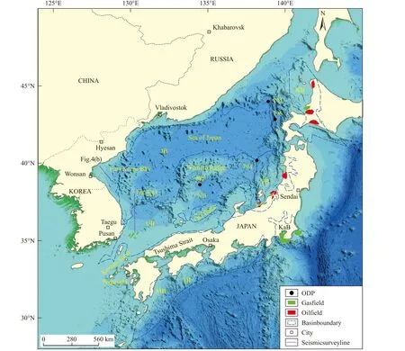
Fig.1.Basin distribution map of the Sea of Japan (modified from Koizumi I and Ikeda A, 1997).J B-Japan Basin; Y B-Yamato Basin; U B-Ulleung Basin; N B-Niigata Basin; K B-Kitakami Basin; Ka B-Kanto Basin; M B-Miyazakl Basin; T B-Toki-Tosa Basin.
2.2. Sedimentary Strata
The Sea of Japan is a Cenozoic basin developed on the basement of Paleozoic metamorphic rocks, non-metamorphic rocks and Cretaceous granite, which is mainly composed of shallow sea deposits of Neogene, with Neogene, Miocene,Pliocene and Quaternary mainly developed from bottom to top, and volcanic rocks are mostly associated with each basin(C&C Reservoirs, 2011).The Ocean Drilling Program (ODP)voyage 127 drilled four wells (stations 797, 794, 795 and 796)in the deep-sea basin of the Sea of Japan, obtained large amount of sediments in the sea area of Japan, and drilled into the basement, which completely revealed the sedimentary sequence and characteristics of each basin in the Sea of Japan(Fig.2).We subdivided the stratigraphic sequence into five sections.The first unit is Lower Miocene, which is mainly composed of basalt, rhyolite, pyroclastic sandstone and siltstone.The second sedimentary unit is Middle Miocene,mainly developed calcareous and phosphate mudstone, which is composed of dark mudstone.The C/S of mudstone is close to that of normal marine sediments, but its SiO2content is generally low, and dacite tuff is also developed.The third sedimentary unit is Upper Miocene, which is mainly composed of chert strips and siliceous shale.Black siliceous rocks and light siliceous shale alternate with each other, and slight biological disturbance can be seen in siliceous shale.The fourth sedimentary unit is Pliocene, which is mainly composed of variegated diatom mud and diatomaceous earth.Except for some scattered yellowish brown carbonate rocks and volcanic clastic sandbeds, there is almost no difference in lithology.Mudstone C/S shows that the sediments in this period belong to normal oxygen-enriched marine sediments.The fifth sedimentary unit is Quaternary, which is mainly clay layer.Dark silty mudstone (with biological disturbance) and light silty mudstone (containing a large number of thin volcanic ash interbeds) are interbedded.The dark layer is rich in organic matter and pyrite, and has a low C/S ratio.The periodic alternation of bright layer and dark layer reflects that the oxygen content of bottom water fluctuates between oxygen enrichment and oxygen deficiency (even in still water).Clay layer contains a small amount of biogenic silicon, and is rich in terrigenous components such as feldspar, illite, kaolinite and chlorite.

Fig.2.Core histogram of ODP voyage 127 (see Fig.1 for drilling location).
The middle-late Miocene siliceous mudstone and siltstone provide an excellent geological record of the Sea of Japan(Martizzi P, 2021; Fig.3).The strata of middle-late Miocene are composed of hard, siliceous mudstone, which show cyclic alternation of light and dark layers.Moreover, the thickness of the dark and light mudstone horizons varied from a few centimeters to a few meters, while the numbers of light and dark mudstone horizons are comparable.
3.Data sources and methods
The data used in this study are mainly based on peerreviewed papers and collected data.Including public data:Global geothermal flow database, Japan-Haiti heat flow data.Collected data of oil and gas fields and drilling from Ihs markit, Compagnie Générale de Géophysique and other companies.Multi-channel seismic profiles are from published literature (Chough SK and Lee KE 1992; Kim GB et al.,2011) and the seismic data collected by BGP in East Korea Bay.
The seismic data were interpreted using IHS Kingdom(ver.8.6; Seismic Micro-Technology).We performed the seismic stratigraphic interpretation based on Mitchum JR et al.(1977).The seismic interpretation procedures included six seismic boundaries, which were separated into five seismic units.
4.Results
4.1. Stratigraphic sequence
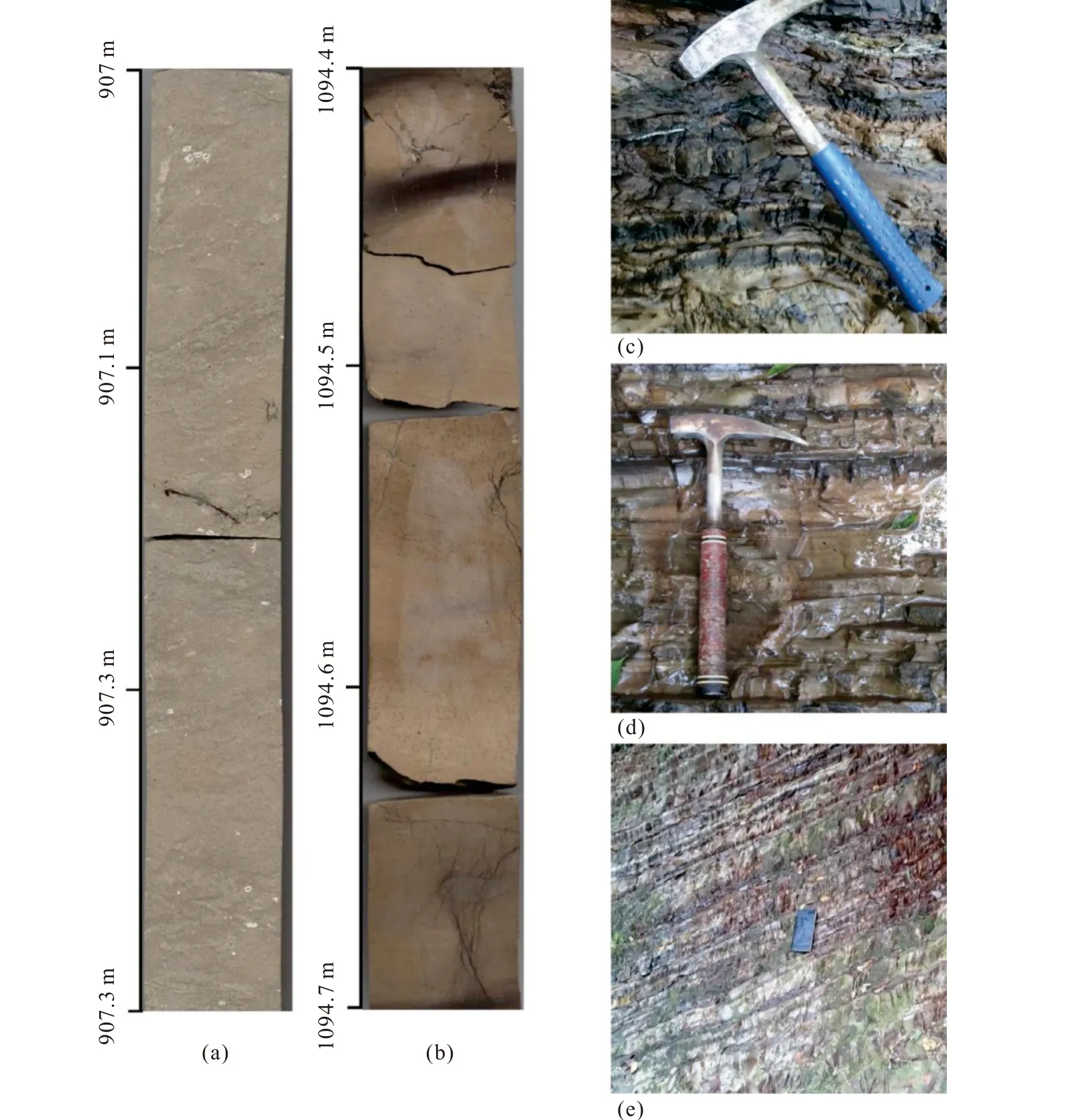
Fig.3.Photographs of core splits and the sampling outcrops of the middle-late Miocene.a-Massive bioturbated diatomaceous siltstone;b-massive siliceous mudstone; c-alternations of light and dark massive mudstone; d-alternations of light and dark laminated mudstone; e-laminated mudstone.
In this study, we adopted the interpretation scheme of Lee GH et al.(2001).According to the wave impedance characteristics of reflection interface of typical through seismic profiles, combined with regional geological data, the reflection characteristics of seismic profiles in the study area are analogously analyzed, and six sequence interfaces with obvious characteristics, including T1, T2, T3, T4, T5and T6,are identified in Japan Sea Basin, and SU1, SU2, SU3, SU4 and SU5 stratigraphic sequences are divided (Fig.4).
SU1 is characterized by low frequency, low to high amplitude reflection, with weak internal reflection energy and poor continuity, indicating volcanic rock deposition and sandstone deposition, which is presumed to be from the early Miocene to the middle and late Miocene.
SU2 is characterized by low frequency, low to high amplitude reflection, with weak internal reflection energy and good continuity, which indicates marine deposition, which is presumed to be from Late Miocene to early Late Miocene.
SU3 is characterized by medium-to-high-frequency, highamplitude reflection, strong internal reflection energy, sheet reflection, and good continuity, indicating deep-sea deposition, which is presumed to be early late Miocene to middle late Miocene.
SU4 is characterized by medium to high frequency, low to high amplitude reflection, with strong internal reflection energy and good continuity, which indicates deep-sea deposition, which is presumed to be the middle of Late Miocene to the late of late Miocene.
SU5 is characterized by low to medium frequency and low to high amplitude reflection, with weak internal reflection energy and good continuity, indicating shallow sea facies deposition, which is presumed to be from the late Late Miocene to the present.
4.2. Geothermal field characteristics
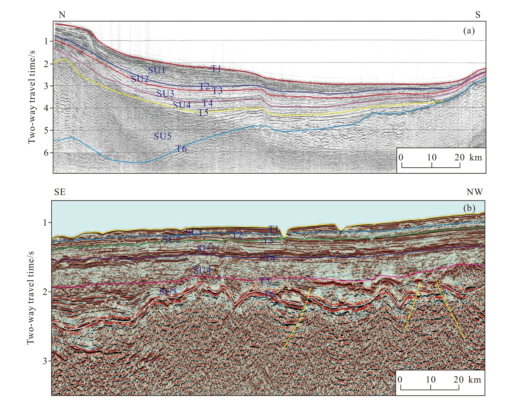
Fig.4.Seismic data interpretation profile (see Fig.1 for profile location).T1, T2, T3, T4, T5,T6 indicate seismic reflection horizon; SU1, SU2,SU3, SU4, SU5 indicate stratigraphic sequences.
The back-arc basin is a deep-sea basin near the mainland side of the island arc belt, which is mainly developed under the subduction of oceanic plate to continental plate.This makes the asthenosphere heated and warmed up and induced a small-scale thermal convection in the back-arc area.Part of the upper mantle material diapir is caused to flow upward and the upper lithosphere generates tension, forming a back-arc basin group.Basins located in the transition zone from continental crust to oceanic crust gradually thinning, having shallower Moho buried depth and thinner continental crust from continental margin to deep sea.The crustal properties are transformed from continental crust Xiang Yang crust, and the heat flow field and terrestrial heat flow are increasing.The northwest Pacific Ocean-continental transition zone has complex structural characteristics, and the boundary of plate collision and some super-shell faults provide a better pathway for the upwelling of thermal matter in the deep earth.Based on previous studies (Xu X et al., 2011; Zhao FY et al., 2017),we collected a large amount of heat flow data, and compiled the superimposed map of heat flow value and basin (Fig.5).It can be seen from the figure 5 that the regional heat flow feature is the most important geophysical field feature in the Sea of Japan, and the heat flow value is abnormally high.The deep-water area of Japan Sea is characterized by high surface heat flow and in consistent with the thinning trend of crust and lithosphere.The strong back-arc expansion thins the crust in the deep-water area, the Moho surface rises rapidly, the corresponding mantle lithosphere also thins strongly, and the mantle asthenosphere obviously uplifts, resulting in the increase of surface heat flux.The Sea of Japan is generally characterized by high heat flow value, which is distributed annularly around Yamato Ridge.The heat flow values of Japan Basin, Yamato Basin, Niigata Basin and Ulleung Basin are 80-130 MW/m2, while the north basin in front of the arc has low heat flow value, which is between 50-90 MW/m2.The characteristics of total heat flow distribution are related to the main topographic changes, the depth of Japan Basin is deeper and the heat flow value is higher, while the depth of Yamato Basin is slightly shallower than that of Japan Basin,and its heat flow value is slightly lower, and the heat value in the eastern part of the basin is higher.The distribution range of heat flow is consistent with the deep-water area of marginal basin, and decreases with the increase of mantle top depth,which indicates that mantle material is the main source of high heat flow.The high heat flow generated by lithosphere stretching and thinning and mantle uplift ensures the mature evolution of organic matter.The geothermal flow distribution in the basins around the Sea of Japan is closely related to enrichment, accumulation, migration and accumulation laws of oil and gas, and the geothermal flow and geothermal field in the basin are distributed, which controlled and influenced the law of oil and gas migration, accumulation, distribution and enrichment in the basin.
4.3. Tectonic-sedimentary evolution characteristics
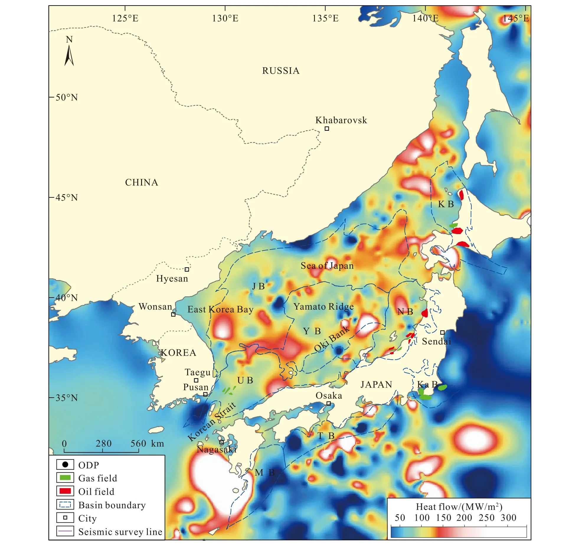
Fig.5.Distribution map of heat flow around the Sea of Japan.
Japan’s gully-arc-basin system is located between Pacific plate, Eurasian plate and Philippine plate.Before Miocene,tectonic magmatism was generally intense, which resulted in deformation and metamorphism of sedimentary bodies before Miocene.After Miocene, tectonic activities become weakened, and the area began to deposit stable sediments.Interaction between plates and complex regional tectonic background control and influence the development and evolution of basins.Generally speaking, the tectonicsedimentary evolution of petroliferous basins in Japan can be divided into four stages (Table 1; Figs.6, 7).
4.3.1.Pre-Neogene:subduction period
Pre-Neogene is majorly influenced by the subduction of Philippine plate and Pacific plate to Eurasian plate (Kang YS et al., 2012; He LY et al., 2016).The regional tectonic magmatic activity was generally intense, which was in accordance with the subduction period of various basins in this region, with volcanic rocks and metamorphic rock basement mostly developed.Neogene strata was only developed in Ulleung Basin, Japan Island Arc and local areas of the pre-arc basin.Ulleung Basin is deposited with pre-Neogene alluvial fan-fluvial facies, mainly composed of glutenite, mudstone and volcanic rocks.Miyazaki Basin is filled with littoral and neritic clastic rocks, showing a progradational sedimentary sequence with shale at the lower part and sandstone-conglomerate at the upper part.In Paleogene, the lower part of Kanto Basin is shallow marine shale, the middle part is littoral glutenite, and the upper part is shallow marine shale.
4.3.2.Early Miocene-Middle Miocene:development period
After the Late Oligocene, the Philippine microplate subducted northward, resulting in the rotation of the southwest end of the Japanese archipelago, and split of the Sea of Japan, and the appearance of oceanic crust.Japanese island arc islands entered the basin development period(Honza E, 1995).At this time, the typical characteristics of this area are as follows: in the back-arc, the Sea of JapanBasin is in its initial stage and receives sedimentation; The forearc area mainly receives the stable deposition of the marine-terrestrial transitional facies and marine facies.Among them, the Sea of Japan Basin, Ulleung Basin and Yamato Basin are mostly filled with mud shale of semi-deep sea-deep sea facies, glutenite of basin bottom fan facies and a small amount of volcanic rocks.Niigata Basin is filled with littoral-semi-deep sea facies sandstones, submarine fan facies sandstones and volcanic rocks.In the forearc area, fan delta conglomerate is developed in Miyazaki Basin; Kanto basin develops semi-abyssal-abyssal mudstone, submarine fan conglomerate and submarine volcanic rocks.
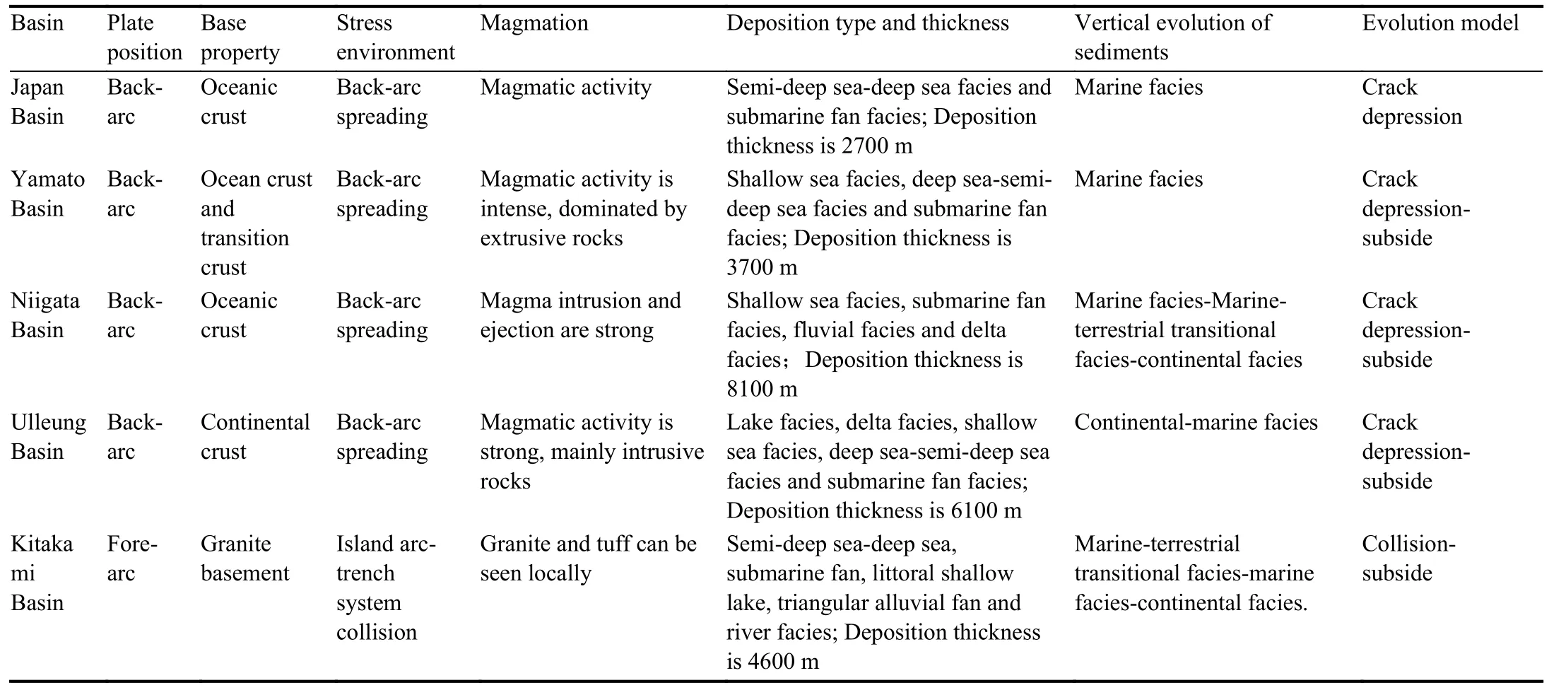
Table 1.Tectonic-sedimentary characteristics of basins around the Sea of Japan (modified from He LY et al., 2016).
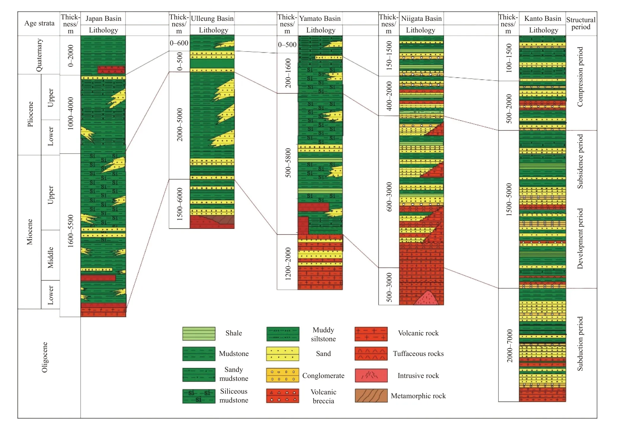
Fig.6.Division map of tectonic stages of basins around the Sea of Japan (modified from Mao SW et al., 2017).
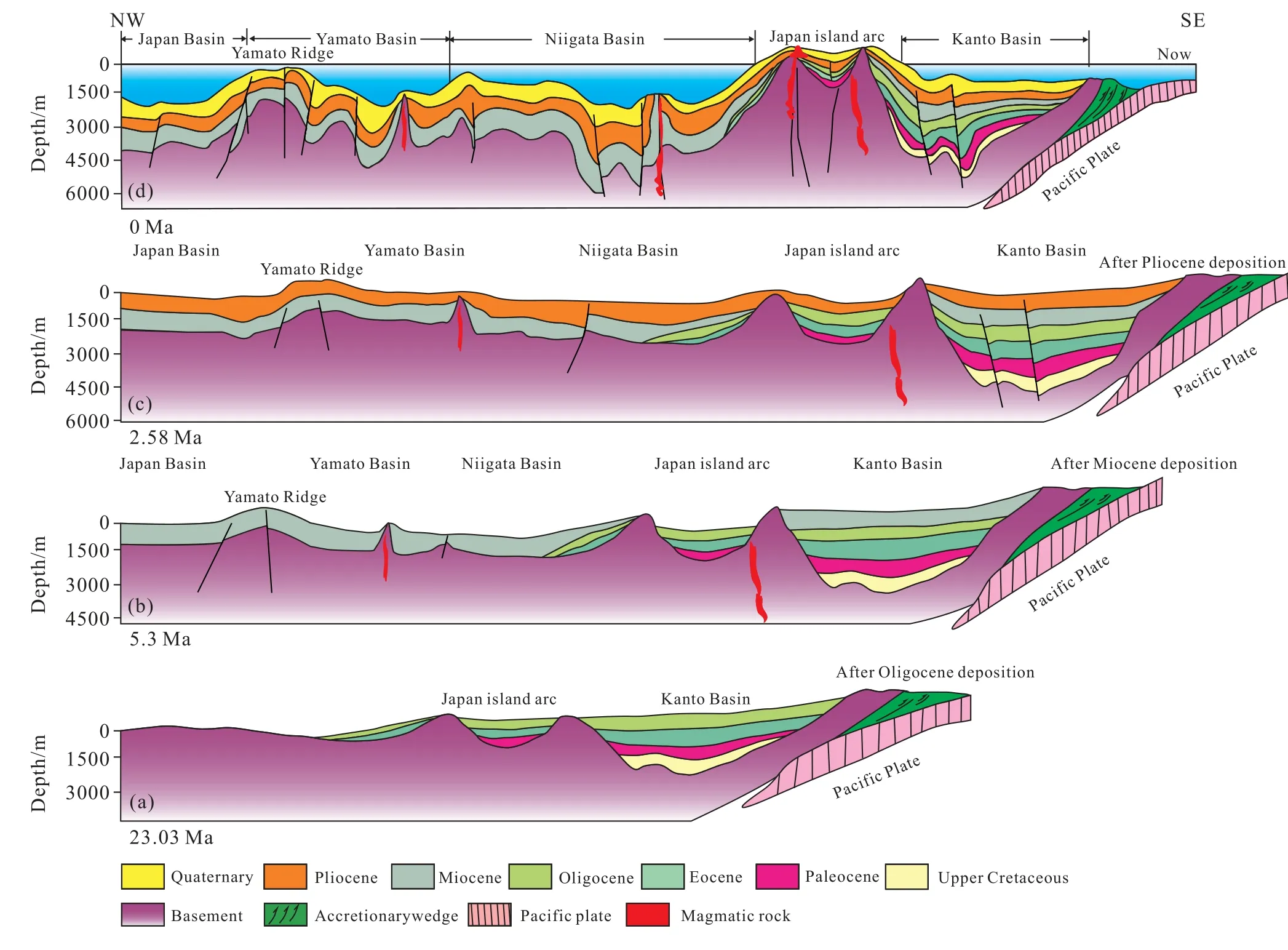
Fig.7.Tectonic evolution profile of the Sea of Japan.
4.3.3.Late Miocene:subsidence period
After Middle Miocene, the northward migration rate of the Indian Ocean plate further decreased, while the Philippine micro-plate and the Australian micro-plate continued to advance northward, resulting in left-handed compression and torsion in the Sea of Japan and the South China Sea.The basins of the Sea of Japan and the South China Sea were closed, and the Japanese island arc basins entered the subsidence period.In the Late Miocene, the volcanic quiet period occurred in the forearc area, during which marine transgression occurred, and ittoral shallow sea-semi-deep sea and deep-sea facies deposits were mainly developed l.Miyazaki basin is filled with shallow marine mudstone and siltstone, The Kanto Basin is filled with shallow marine mudstone and littoral glutenite.The Japan Basin, Ulleung Basin and Yamato Basin in the back-arc area are filled with semi-deep to deep sea facies shale and basin-bottom fan facies glutenite, and lack of volcanic rocks.Niigata Basin is filled with semi-abyssal to abyssal shale and basin bottom fan facies glutenite, with a small amount of volcanic rocks (Xu YD et al., 2014; Mao SW et al., 2017).
4.3.4.Pliocene to present:compression period
Since Pliocene, the regional tectonic stress has changed from tensile stress to compressive stress (Zhao JH, 2004; Li SZ et al., 2013; Li XJ et al., 2017).All basins in Japan have entered the compressive period as a whole, mainly developing river-delta-marine sedimentary system, while some deepwater basins were less affected by sea level change, and still developed deep-sea and semi-deep-sea mudstone and turbidite.In the back-arc area, Japan Sea Basin and Yamato Basin are still filled with semi-abyssal-abyssal shale, mixed with conglomerate at the bottom of the basin, while the Ulleung Basin is filled with coastal and shallow-sea sandstone and mudstone facies.The Niigata Basin is mainly filled with river-littoral shallow sea facies glutenite and mudstone.In the forearc area, Miyazaki Basin develops shallow sea-semideepsea, deepsea facies shale and submarine fan facies conglomerate with a small amount of fan delta facies glutenite.Kanto Basin is filled with river-delta-littoral shallow sea facies glutenite and mudstone.
5.Discussion
5.1. Tectonic-sedimentary characteristics of back-arc basin
The tectonic-sedimentary characteristics of the back-arc basin are as follows: (1) Due to the influence of plate subduction and retreat and the expansion of the back-arc oceanic crust, the back-arc area has strong tectonic activities and frequent volcanic activities; (2) large accommodation space and deep subsidence.The sedimentary thickness is between the continental shelf marginal basin and the fore-arc basin, with an average of 4800 m.From subduction to subsidence period, the sedimentary water becomes shallower and gradually changes from deep-sea to shallow-sea delta facies.Gravity flow sediments are well developed and riverlake sediments are locally developed.It has two-directional provenance of Eurasian plate and island arc; (3) the evolution is affected by the distance of provenance.Near the provenance, the land-sea transitional facies deposit is dominant, and the delta facies is relatively developed, while far away from the provenance, deep-sea and semi-deep-sea facies are dominant, and are less affected by tectonism (He LY et al, 2016; Jiang SH et al., 2019).
The sedimentary sequence of the back-arc basin is characterized by coarseness at the bottom and fineness at the top.In the initial development period of the basin, shallow water or continental sediments are the main ones, and in the stage of intense tension, the crust is rapidly thinned, the basement subsidence rate is fast, and deep-sea and semi-deepsea sediments are developed.Especially near the island arc,there are almost no continental deposits.The sediments have obvious double-layer structure, and shallow water sediments suddenly contact with the deep-water sediments.When that back-arc basin disappears and the forms back-arc foreland basin, the stratigraphic sedimentary sequence has the characteristic of molasse sediments covering deep-water sediments.The tectonic evolution of the basin and the change of sedimentary environment control the change of lithofacies.In the Early stage of synrift period, the developed graben is often filled with alluvial fan and lake-delta depositional system, in which alluvial fan glutenite is poorly sorted and reservoir quality is poor.In the late synrift period,transgression gradually increased.The sedimentary environment has changed to open sea, and marine shale is developed in the basin, but its reservoir performance is also poor, and it is only used as source rock and cap rock.In the early post rift period, extensive transgression occurred in the basin, open marine shale and carbonate rocks were developed widely, and the reservoir performance was medium to good.In the late rift period, affected by tectonic uplift and inversion,a wide range of delta depositional systems developed in the basin, which usually formed good reservoirs.
5.2. Hydrocarbon generation characteristics under high heat flow background
The geothermal characteristics of the basin are related to the geotectonic position of the basin, which is a comprehensive reflection of tectonic action.Geothermal energy restricts and influences the deformation and evolution of lithosphere by providing energy and changing the mechanical properties of rocks, and it is also the key factor controlling dispersed organic matter distributed in source rocks to generate oil and gas.When other geological conditions are the same, large oil and gas fields may form in areas with high heat flow (Xu X et al., 2011; Chen LB et al.,2015; Chen JP, 2021).Back-arc basins in the island zone belong to Cenozoic sedimentary basins with high geothermal gradient.These basins have high geothermal field and heat flow, which will enable shale organic matter to accelerate pyrolysis and generate hydrocarbon, and become an effective source rock, which is beneficial to oil and gas generation (Luo JL et al., 2019; Mi LJ et al., 2019).The geothermal gradient is generally higher in back-arc basin group of the Sea of Japan due to the thinning of crustal tension, the rising of deep magma and the influence of thermal convection.As a result,most of the source rocks in the study area are in the maturity and over-maturity stage, mainly in the stage of condensate and moisture window and gas window, and the hydrocarbon products mainly generate a large amount of natural gas,accompanied by a small amount of condensate and light oil(Table 2).
The high heat flow background can provide unique thermal evolution conditions for diagenesis and hydrocarbon generation, and lead to the particularity of oil and gas types and reservoirs.The current geothermal flow of Japan Sea is about 50-130 MW/m2, and the average heat flow is 75.9 19.8 MW/m2.This is a typical “hot basin”.The intense extension and detachment of the lithosphere, as well as the abnormalactivities of the deep mantle material and the deep geothermal fluids, led to the obvious increase of geothermal flows in the study area, and the geothermal flow and geothermal field are high, accompanied by complex multi-stage tectonic movements and thermodynamic processes.Tectonic thermal evolution events affect the strata.According to the theoretical simulation results of hydrocarbon generation history (Fig.8),when the local temperature gradient increases from 3°C/100 m to 5°C/100 m, the buried depth of the source rock entering the main oil generation window can be reduced from 4200-5700 m to 2600-3600 m, and the buried depth of the main gas generation window can be reduced from 5700-6800 m to 3600-4200 m.In addition, it is easier to generate liquid hydrocarbons under the background of high ground temperature (Pang X et al., 2018).With the increase of geothermal gradient, the favorable reservoir depth becomes shallower, and the hydrocarbon generation window (Rovalue is 0.7%-2.0%) becomes narrower.When the local temperature gradient is (3.0-4.0) (°C/100 m), it is in the early stage of oil and gas generation and hydrocarbon expulsion.The permeability of surrounding sandstone is generally good,and it can discharge oil and gas in the form of buoyancy, so it is easy to form conventional oil and gas reservoirs.When the local temperature gradient is greater than 5.0°C/100 m, the surrounding sandstone is already dense when a large amount of hydrocarbon is expelled from the source rock, and the capillary resistance is high, so it is difficult to transport oil and gas in the form of buoyancy.Therefore, hydrocarbon generation overpressure, phase potential driving and episodic hydrocarbon expulsion may be the main hydrocarbon accumulation modes.The geothermal gradient in the offshore basins of Japan is generally greater than 5.0°C/100 m.Under the condition of high geothermal field in hot basin-super-hot basin, the thermal maturation of source rocks is accelerated,thus promoting the hydrocarbon generation process of source rocks.The source rocks are characterized by high temperature and rapid evolution, such as early hydrocarbon generation,rapid maturation, shallow and narrow hydrocarbon generation window, as well as special hydrocarbon generation conditions and hydrocarbon generation evolution process, such as easy generation of overpressure.
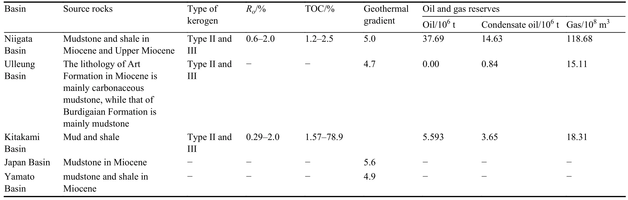
Table 2.Characteristics of source rocks and distribution of oil and gas reserves in basins around the Sea of Japan (modified from He LY et al., 2016; Mao SW et al., 2017).
5.3. Reservoir forming characteristics

Fig.8.Thermal evolution characteristics of source rocks under the background of high heat flow.
The Sea of Japan is an important part of the trench-arcbasin system in the western Pacific Ocean.It is located in the active continental margin background, and it is easily flexed due to regional compression.The formed basin has the characteristics of large subsidence thickness, deep subsidence and large accommodation space (Lee GH et al., 2004, 2011;Jiang H and Gao XL, 2012).The basins where oil and gas have been found are Niigata Basin, Ulleung Basin and Kitakami Basin, all of which have crust thickness of more than >18000 m, and the maximum sedimentary thickness of Niigata Basin exceeds 8000 m.The maximum sedimentary thickness of Ulleung Basin is 6100 m.The maximum sedimentary thickness of Kitakami Basin is 6100 m.The sedimentary environment of the basins around the Sea of Japan is dominated by littoral-shallow sea-delta transitional facies, with poor-moderate abundance of organic matter and II-III kerogen type.However, the shale in some continental lake basins is rich in organic matter, and the kerogen type is I-II.For example, the source rocks in Niigata Basin are mainly of type II-III.The maturityRoof source rocks in late Miocene Teradomari formation is 0.6%-2.0%, TOC is 1.2%-2.5%, which is favorable for oil and gas generation(Lee GH and Kim B ,2002; Mao SW et al.,2017).At the same time, the back-arc basins often develop sedimentary environment of marine-terrestrial transitional faciescontinental.The delta sand and conglomerate, underwater fan turbidite, clastic flow and silty turbidite are all developed,which can be considered as good reservoirs, among which sand layer and weathered layer have good porosity and permeability conditions and have good reservoir conditions.Volcanic rocks, tuff strata and basement fractured reservoirs are also good reservoirs.For example, marine sandstone developed in Middle-Upper Miocene is the main reservoir in Niigata Basin, with an average porosity of about 15% and a permeability of 10-100 mD.The fractured reservoirs in the basement of kitakami Basin have good physical properties,with porosity of 12%-25%, permeability of 15-120 mD, the local permeability can reach 500 mD (Mao SW et al., 2017).
In addition, the interbedding of mud (shale) and sandstone can be used as cap rock.Under the influence of compression and torsion,
many sets of anticline, faulted anticline and fault block traps controlled by reverse faults can be formed in the backarc basin.In addition, affected by plate subduction and mantle upwelling, the back-arc basin is vulnerable to magmatic intrusion locally, and a series of lithologic traps can be developed around it, which determines that there are many types of traps in the back-arc basin.In terms of migration and accumulation, the extensional faults in the back-arc basin are well developed and are the main pathways for oil and gas migration.After the formation of the basin, it often does not suffer from strong tectonic movement, and the internal sand body has relatively good continuity, which can be combined with tensile faults to form a stepped migration pathway.The back-arc basins in Japan experienced back arc expansion at the initial stage of formation, forming structural units similar to continental rift basins, which was conducive to the formation of subsidence centers and thicker source rocks.Under the influence of late tectonic compression, faults in the basin are relatively developed.After generation, oil and gas migrate upward or downward along the migration channel.In the vertical direction, it mainly shows the reservoir forming characteristics of lower generation and upper generation,forming a vertical migration-fault channel reservoir formation model.For example, in Niigata Basin, after the source rocks generate hydrocarbon, most of the oil and gas will enter overlying strata along the migration pathway (Fig.9a).In Kitakami Basin, some oil and gas will migrate along the fault to the underlying bedrock formation, forming basement fractured oil and gas reservoirs or volcanic oil and gas reservoirs (Fig.9b).
5.4. Oil and gas resources prospect
Regionally, Niigata Basin, Kitakami Basin, Ulleung Basin, Kanto Basin and Miyazaki Basin have good oil and gas display and are the main oil and gas producing basins.According to IHS data by 2020, 148 oil and gas fields have been discovered in Japan, and the geological reserves of oil and gas are 255.78×10⁶t, including 43.29×10⁶t of oil,19.59×106t of condensate and 226.31×10⁸m3of natural gas(IHS, 2020).The oil and gas exploration in Japan has proved that the vertical distribution of oil and gas has certain regularity, with natural gas mainly distributed in Pliocene and Pleistocene with buried depth less than 1000 m, and oil and condensate mainly distributed in Miocene with buried depth of 3000-4000 m (Mao SW et al., 2017).In the distribution of strata, the discovered and exploited oil and gas are mainly distributed in Neogene, while the distribution of oil and gas in other strata is relatively small.At present, there are 93 commercial oil and gas fields in Niigata Basin, of which more than 95% have found abundant oil and gas reservoirs in Miocene-Pliocene reservoir-forming structural-lithologic traps, and the oil and gas reserves are mainly concentrated in Miocene, with the geological reserves of 156.07×10⁶t.Among the 23 oil and gas fields under production in the Kitakami Basin, oil and gas discoveries are mainly distributed in the Lower Cretaceous-Lower Pleistocene reservoir-forming combination, which has a good source-reservoir allocation relationship and shows good oil and gas potential.The geological reserves of Neogene oil and gas are 12.67×10⁶t.The oil and gas in Ulleung Basin are mainly found in Neogene, and its geological reserves are 13.72×10⁶t (IHS,2020).

Fig.9.Hydrocarbon accumulation model of the Sea of Japan (modified from Mao SW et al., 2017).a-Reservoir formation model of vertical migration fault channel; b-reservoir formation model of basement fractures.
The tectonic movement at the end of Oligocene resulted in the thinning of the crust in the basins around the Sea of Japan,the increasing of heat flow in the crust and sedimentary rocks,and the strong expansion, which led to the development of marginal seas with ocean basin characteristics and corresponding trench arc systems in the Sea of Japan, such as the Yamato Basin (Wakita K, 2013).At the same time, due to the constant movement between plates, between plates and blocks or between blocks, the large strike-slip fault zone in the study area is well developed.The basins around the Sea of Japan were filled with dark marine shales which are rich in organic matter in the early rift stage.In the late stage of synrift development, turbidite system developed and many sets of sand reservoirs were formed.Since the end of Miocene, it has been the most active period of thermal subsidence in Cenozoic basins in the transitional zone between ocean and land, and with the reactivation of postcrack structures, various types of traps related to faults have developed in basins around the Sea of Japan, including anticline traps, fault blocks reformed by later structures and lithologic traps, resulting in the development of structural traps in different places in different periods, followed by lithologic traps and compound traps.Generally speaking, the basins around the Sea of Japan have high geothermal flow and geothermal gradient, and the source rocks are mainly of type II and III, with various types of reservoirs and traps, good conditions for hydrocarbon accumulation, multiple sets of favorable hydrocarbon accumulation combinations, and good oil and gas exploration potential (Table 2).
At present, the oil and gas fields in the sea of Japan are mainly located in Niigata Basin and Ulleung Basin.According to the burial history simulation results, Miocene source rocks have entered the hydrocarbon generation threshold since the middle Miocene, generating and discharging hydrocarbons, and the oil and gas migrate and accumulate to the adjacent traps (Lee GH and Kim B, 2002;Fig.10).The Miocene-Pliocene reservoir-forming combination is the most abundant reservoir found so far, with good source-reservoir configuration.At the same time, due to the influence of intermittent volcanism, faults are relatively developed and the geothermal gradient is relatively high,which accelerates the maturity of source rocks in the basin.After the generation of oil and gas, it migrates to tuff reservoirs and congolomerate reservoirs with good reservoir physical properties.It has good oil and gas potential and is the key direction of future exploration and development in the basin.At present, the trap types of oil and gas discovery are mainly concentrated in the exploration stage of structural traps, and the discovered oil and gas are mostly concentrated in structural traps, with a large proportion of structural oil and gas reservoirs, while lithologic reservoirs and stratigraphic reservoirs are relatively few.With the increasing of exploration activities and the improvement of various exploration technologies, lithologic reservoirs, stratigraphic reservoirs and pre-Neogene bedrock reservoirs will gradually increase, which is an important field for increasing reserves and increasing production in the Sea of Japan, and will also become an important target for oil and gas exploration in the future.
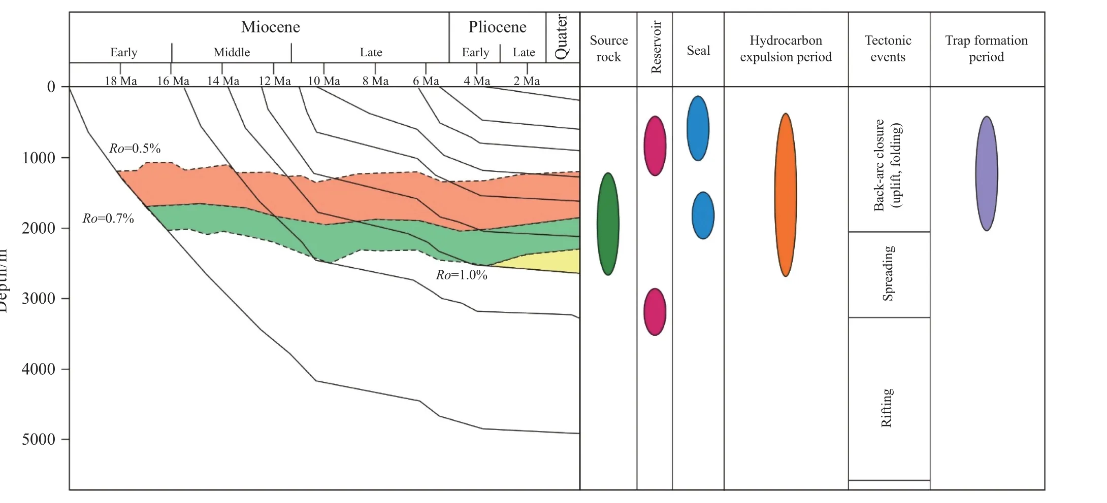
Fig.10.Matching diagram of reservoir forming event map of Niigata basin.
6.Conclusions
(i) The Sea of Japan is located in a special structural position of complex transitional crust or locally thin crust, and the geothermal flow and geothermal gradient are generally high.The main hydrocarbon resource is natural gas, and a large number of natural gas fields and oil and gas fields are distributed in this area.Therefore, regional geological background and the differences of geothermal flow distribution directly control the distribution, migration,accumulation and enrichment of oil and gas in sedimentary basins.
(ii) The Sea of Japan is an important part of the trencharc-basin system in the western Pacific Ocean, and it has experienced complex tectonic evolution periods.It has mainly experienced four tectonic-sedimentary evolution stages,among which the subsidence period is Miocene, which is the key period for oil and gas generation.Hydrocarbon migration and accumulation are mainly characterized by lower generation and upper storage and upper generation and lower storage, forming a vertical migration-fault channel reservoirforming model.
(iii) The oil and gas of the Sea of Japan are mainly concentrated in Neogene and Pre-Neogene oil-bearing strata,mainly forming structural traps, lithologic traps and compound traps and a small amount of stratigraphic traps.Niigata Basin, Ulleung Basin Basin and Kitakami Basin have good oil and gas resources potential and are the main targeting areas for future exploration and development.
CRediT authorship contribution statement
Jian-qiang Wang, Jie Liang and Jian-wen Chen prepared the manuscript.Qing-fang Zhao, Yin-guo Zhang, Jian-wei Zhang, Lee-Jel Jiang, Sen Li and Chang-qing Yang drew all the figures.Jian Zhang, Jing Sun, Chuan-sheng Yang and Yong Yuan supervised the findings of this work.All authors discussed the results and contributed to the final manuscript.
Declaration of competing interest
The authors declare no conflicts of interest.
Acknowledgment
This research was jointly supported by the Major Project of National Laboratory for Marine Science and Technology(Qingdao) (2021QNLM020001-1, 2021QNLM020001-4), the Project of China Geology Survey (DD20221723,DD20230317), the National Natural Science Foundation of China (41776075, 42076220 and 42206234), the Natural Science Foundation of Shandong Province (ZR2020QD038);the Major Basic Research Projects of Shandong Province(ZR2021ZD09).The APC was funded by the Qingdao Institute of Marine Geology, China Geological Survey.The reviewers have given valuable opinions and suggestions, and I would like to express my heartfelt thanks.
杂志排行
China Geology的其它文章
- A three-dimensional Moho depth model beneath the Yemeni highlands and rifted volcanic margins of the Red Sea and Gulf of Aden, Southwest Arabia
- Discovery of bauxite-type helium source rock in Jinzhong basin, central North China and its resource potential evaluation
- Reply: Comment on “Geological mapping and mining prospecting in the Aouli inlier(Eastern Meseta, Morocco) based on remote sensing and geographic information systems (GIS)” by Benaissi et al.(China Geology, 5 (2022))
- Heavy metal pollution assessment in marine sediments in the Northwest coast of Sabah,Malaysia
- Health risk assessment of heavy metals in soils and crops in a mining area (Au-Ag-Cutrona-oil et al.) of the Nanyang Basin, Henan Province, China
- Melt extraction and mineralization: A case study from the Shuangjianzishan supergiant Ag-Pb-Zn deposit (208 Mt), Inner Mongolia, NE China