Reply: Comment on “Geological mapping and mining prospecting in the Aouli inlier(Eastern Meseta, Morocco) based on remote sensing and geographic information systems (GIS)” by Benaissi et al.(China Geology, 5 (2022))
2023-12-15LkhlifBenissiAdnneToiKhlidElAmriMohmedHiti
Lkhlif Benissi, Adnne Toi,*, Khlid El Amri, Mohmed Hiti
a Laboratory of Georesources, Department of Geosciences, Faculty of Sciences and Technics, Moulay Ismail University, Errachidia 52000, Morocco
b Laboratory of Georesources, Geoenvironment & Civil Engineering, Department of Earth Sciences, Faculty of Sciences and Technologies of Marrakesh, Cadi Ayyad University, Marrakesh 40000, Morocco
We have been pleased that our paperGeological mapping and mining prospecting in the Aouli inlier(Eastern Meseta,Morocco)based on remote sensing and geographic information systems(GIS) was of interest to our colleagues who commented it in China Geology 5 (2022) 1-4; doi:10.31035/cg2022065.However, the use in the comment of expressions such as —bibliographic synthesis poorly constructed; missing points; the authors attempted to; works completely ignored by the authors; the authors did not succeed in, speculative interpretations—makes us believe that the commenters have misinterpreted our paper and might not have fully understood its objective and methods.
A humble, objective, and serious analysis of this comment, through the twenty-one-time auto-citation,highlights two points: (i) the authors’ comment misread our paper, and (ii) what they suggest does not contribute to our study given the objective of our paper and the used tools.
Hereafter, our responses point by point to their comments:
1.Paper objective
Remote sensing is nowadays an essential tool in any geological prospecting study.It allows to explore new territories, as well as others that have been explored traditionally.In the latter case, it enables improvements to be made to the results obtained by the technology of the time.
Most previous studies on the Aouli inlier (Morocco)focused on its cover, with limited exploration in the basement formations.That is why our paper aimed to: (1) use remote sensing as a tool in mining prospection to find potential deposits in the basement formations of the Aouli inlier.This is to reduce prospecting time, target promising areas and at the same time complete and improve the geological map of Emberger A, 1956b and Raddi YO et al., 2013, and (2) check,in the field, the obtained information, before proceeding to the classic development of the deposits.
The authors’ comment raised critics focused on aspects beyond the limits of the remote sensing method that we used:(1) The multispectral remote sensing mapping of geological units with similar mineralogical composition is limited(gabbro-diorites, quartz-diorites, granodiorites, quartzmonzodiorites, and quartz-monzonites) and (2) The 1/200000 map scale used in this work makes it difficult to map small outcrops.On another hand, our working base map is Emberger ’s map at 1/200000, on which the information obtained by remote sensing has been projected.As a result,any improvements made to this map could also be made to the Raddi’s map.
2.Geological and metallogenic setting
The authors’ comment mentioned the absence of a detailed literature review on (1) the Meso-Cenozoic cover of the Aouli inlier and (2) the hosted mineralization.
Our paper, in Fig.2 (named Fig.1 here), does illustrate that the mineralization of the Aouli inlier is hosted in the Paleozoic basement and the Meso-Cenozoic cover.Moreover,sedimentary evolution details and the mineralization of the cover have no interest in our study since we target the mineralized structures hosted in the Paleozoic basement of the Aouli inlier.

Fig.1.Geologic cross section NW-SE of Aouli inlier (Margoum DA, 2015.modified from Emberger A, 1965a, b).

Fig.2.ASTER spectral profiles of the sillimanite- and cordieriteandalusite-rich facies from the contact metamorphism aureole.
Remote sensing technology was applied here to the basement of the Aouli inlier for the following reasons: (1)This domain is generally the host to high-grade mineralization(Pb, Zn, Cu, and ± Ag) presented as the vein-type, hectometers to kilometric extension, are 1 to 8 m thick and well-marked in the field by hydrothermal alteration minerals.(2) But, the mineralization of the Meso-Cenozoic cover deposits, occurs(1) in disseminated form or small clusters impregnating the Triassic arkoses, classified as red beds, and (2) the stratoid clusters hosted in the Middle Liassic dolomitic outcrops(Margoum DA et al., 2015), they are qualified as the Mississippi Valley-type.
For the structural setting, we focused on the Variscan deformation which is responsible for the structuring of the base of the inlier which hosts the mineralization concerned by our study (Rhinane HA, 1990), including the dome of the Adrar-Akorar and most of the major faults corresponding to legacies of this deformation (Emberger A, 1965b).The posterior phases linked to the Atlasic rifting surely have an impact on the mineralization (Margoum DA et al., 2015), but this would not be without the presence of faults inherited from the Hercynian deformation which played major roles in the drainage of hydrothermal fluids source of the mineralization.
3.The updated geological map of the Aouli Inlier
(i) El Hassir granodiorite was considered as a single unit because the spectral signatures of its facies are very similar.Therefore, mapping these different facies cannot be achievable in our case by remote sensing.
For the contact metamorphism, the authors’ comment stipulate that it was not mentioned in our work, while it is well illustrated on the geological map of Aouli inlier and its periphery (Emberger A, 1965b) by the hornfels facies which punctuate the granite facies over the extent of the map.However, it is not possible to make a distinction, by remote sensing, between contact metamorphism mineral zoning(sillimanite, cordierite and andalusite) in the study zone because they have similar reflectance profiles (Fig.2), which express similar chemical compositions Al-rich phyllosilicates(Pour AB et al., 2021).
(ii) For the contradictions between the geological maps of Emberger A, 1965b and Raddi YO et al., 2013, we would like to point out that our main objective is to target potentially mineralized areas in the basement of Aouli Inlier using a remote sensing tool.The basic reference of the work is the Emberger A map, which could also have been the Raddi map.Consequently, our results, after the main objective, enabled us to update the Emberger map, and if these improvements do not meet the authors' comment expectations about the contradictory information on the Raddi map, it could be because the remote sensing used in our work cannot resolve this issue.We would also point out that structures of a very small extent cannot be presented on a map of this scale.Also,formations with similar mineralogy cannot be distinguished by the method.Finally, we have restricted the field checks to areas of interest to our study.
(iii) For the comment regarding the elimination of the“two biotite schist massifs” according to their point locations,we have not eliminated any facies presented in the geological map at 1/50000 of Raddi YO et al., 2013.However, if one looks for these localities on our working base map(Emberger), the first point (X/32.58°W, Y/32.82°N !!) is out of the map zone, and the second (X/4.58°W, Y/32.8°N)corresponds to Triassic cover outcrops with no metamorphic facies.
(iv) Field information given by the authors’ comment about the cover, are surely important for studies such as stratigraphic evolution and correlation between different basins, but not useful in our paper in which we target the potentially mineralized structures in the basement of Aouli inlier.Moreover, many formations or structures are too small to map in a 1:200,000 map scale.
The authors’ comment refers to bibliographical references to say that the upper part of the Triassic series is not represented by micro-conglomerate, red clay with sandstone and dolomite.In this study, we refer to Margoum DA, 2015 to establish figure 5 in Benaissi LA et al., 2022, where the upper part of the Triassic series is represented by microconglomerate, red clay, red sandstone, bedded argillite, and the last Triassic term in the Aouli inlier is represented by tholeiitic basalts-dolerite.
4.The mapping of lineaments and hydrothermal alteration minerals in the Aouli inlier
The authors’ comment contest the validity of the lineament map that we produced following a recognized scientific methodology, which is well illustrated in the flowchart of figure 3 in Benaissi LA et al., 2022.They are convinced that there is no topographic map of the study area just because “to their knowledge as they say”, it does not exist.The map presented in Emberger A, 1965b is surely a geologic map of Aouli, but we used it simultaneously as a topographic map to eliminate the lineaments that coincide with the rivers and the roads.If one disregards the colors representing the formations in this figure, he will see the topographic map.
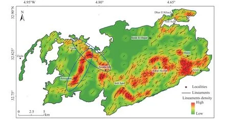
Among the new potential mining exploration areas, we proposed in our article, are the NNE-SSW corridor of Ansgmir and the NW-SE corridor of Assaka Ijdi-Tijouit (Fig.8 in our paper) named (Fig.3) here.There has been confusion among the authors’ comment between these corridors “zones”and “veins”.In this study, the Pb-Zn ± F ± Ba vein system of these two corridors, is characterized by mineralized veins trending ENE-WSW to E-W (Emberger A, 1965b, Raddi YO et al., 2013, Margoum DA, 2015).
5.Structural control of hydrothermal mineralization in the Aouli Inlier
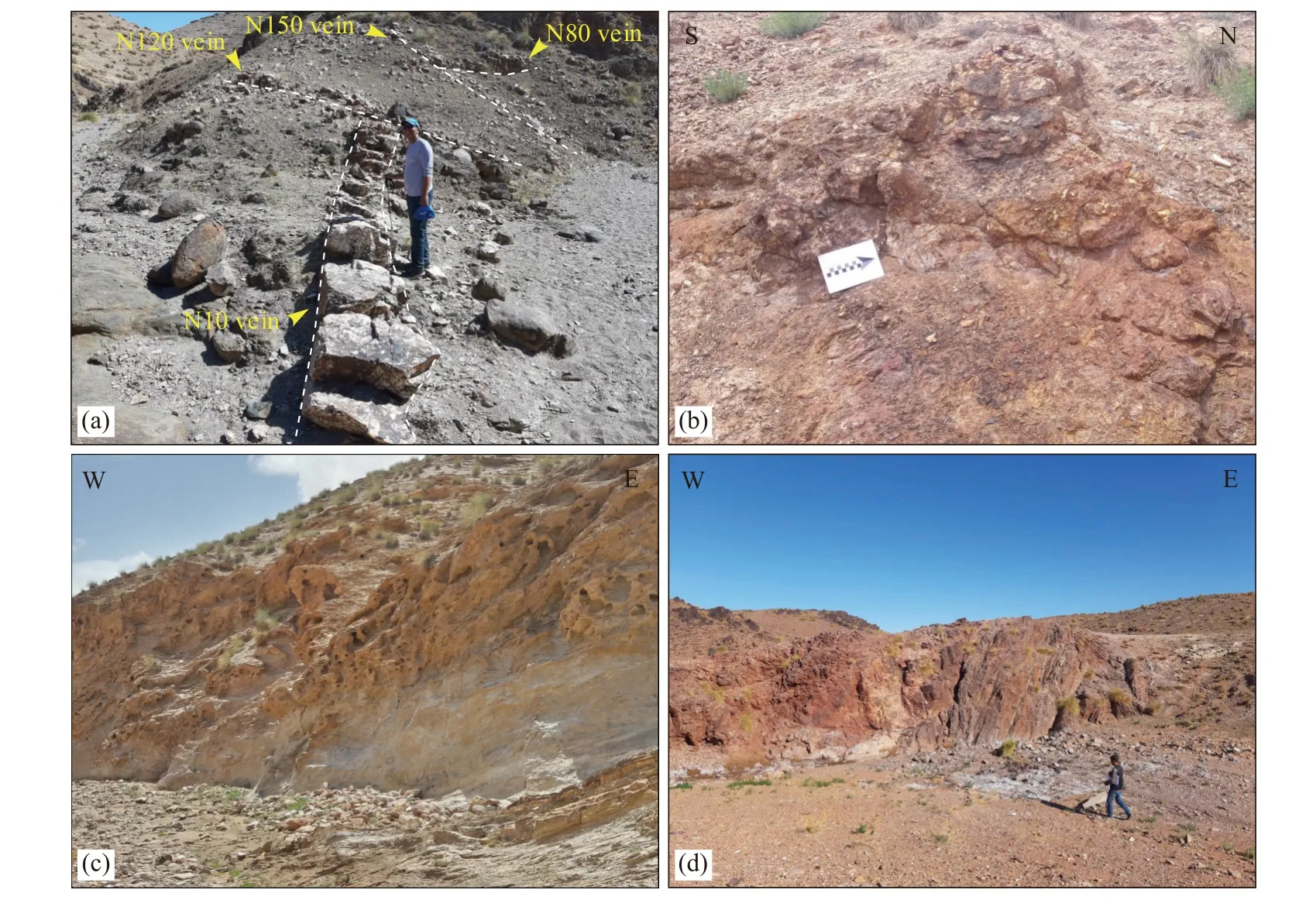
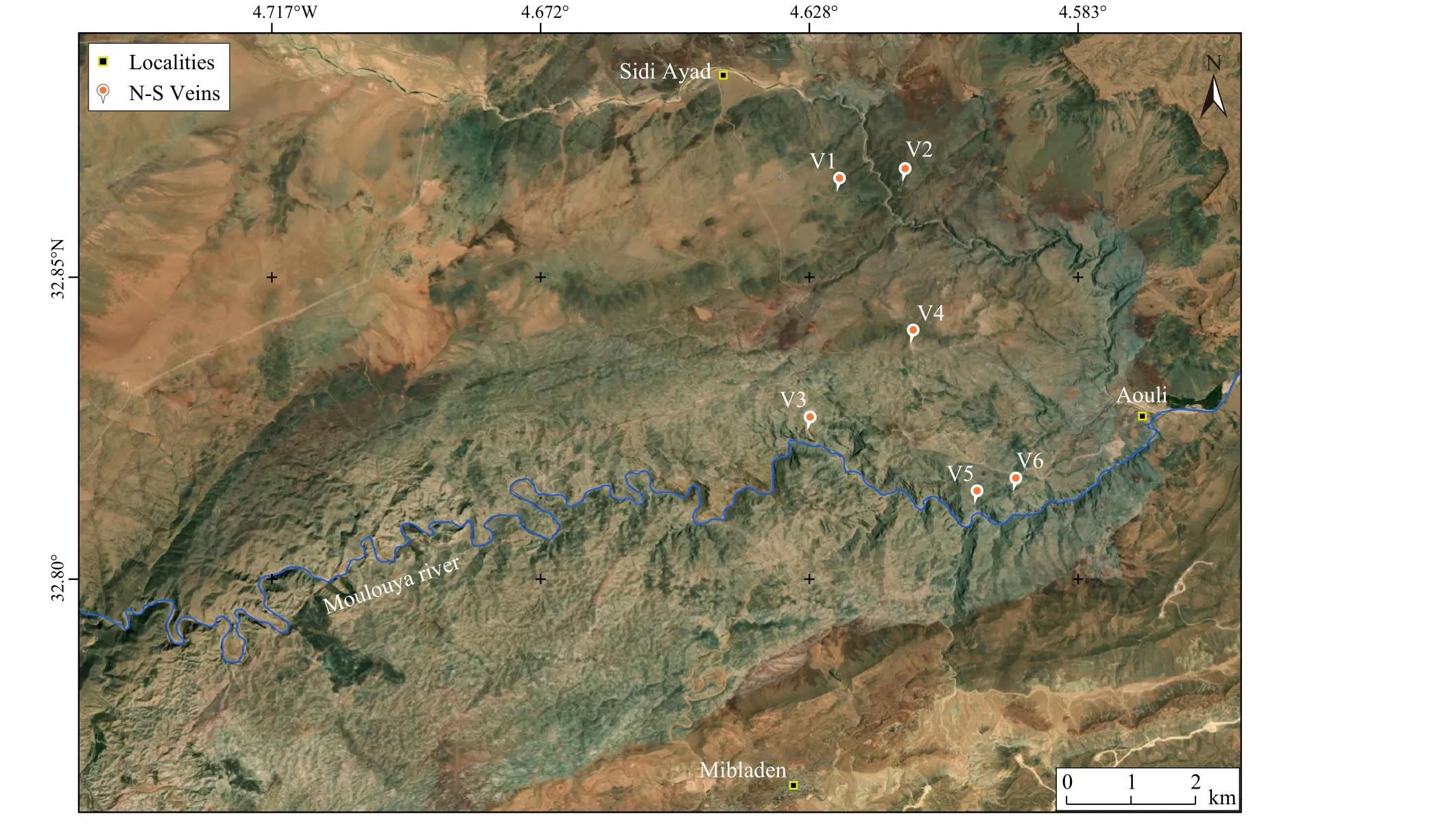
According to the authors’ comment, N-S mineralized veins have never been mentioned in the Aouli inlier.These veins, from which we identified some in our field survey (Fig.4 and Fig.5), do exist, and they are also mentioned in the map of Emberger A, 1965b (Fig.4).Authors’ comment can easily find these structures (not roads, streams or cliffs) at coordinates given in Table 1.Moreover, in their recent paper(Yaagoub DR et al., 2023), the authors’ comment themselves state that the structural analysis allowed them to distinguish the main faults affecting the Paleozoic basement and its Meso-Cenozoic cover.From these faults, they mention the N-S system.

Fig.3.NNE-SSW corridor of Ansgmir and the NW-SE corridor of Assaka Ijdi-Tijouit (circled in blue), correspond to strongly fractured areas (after Benaissi LA et al., 2022).

Fig.4.(a)-Multi-direction of mineralized veins hosted in the Paleozoic basement of the Aouli inlier; (b)-N-S mineralized veins; (c)-E-W shear zones associated with the clay hydrothermal alteration in wadis; (d)-E-W shear zones associated of the ferromagnesian hydrothermal alteration in wadis.

Fig.5.Satellite map showing the location of some N-S veins identified in the field.
6.Conclusion
The comments’ authors have focused their discussion on (1) The geological and metallogenic setting of the Aouli inlier, (2) The updated geological map, (3) The mapping of lineaments and hydrothermal alteration minerals, and (4) Thestructural control of hydrothermal mineralization.However,some proposed amendments are about information that should be included in our paper when they could not be identified by the used remote sensing tool.Others are on the findings in the field which seem irrelevant to us, given the objective of our paper.

Table 1.N-S mineralized veins coordinates in the Paleozoic basement of the Aouli inlier.
So, suggested discussion points by the authors’ comment to help the reader better constrain the complexity of the geology and the mineralization of the Aouli inlier are very interesting but do not bring any insight that adds value to our study.They gave no evidence on the ground nor relevance of the ideas that we would have omitted.
杂志排行
China Geology的其它文章
- Melt extraction and mineralization: A case study from the Shuangjianzishan supergiant Ag-Pb-Zn deposit (208 Mt), Inner Mongolia, NE China
- Health risk assessment of heavy metals in soils and crops in a mining area (Au-Ag-Cutrona-oil et al.) of the Nanyang Basin, Henan Province, China
- Classification and mineralization of global lithium deposits and lithium extraction technologies for exogenetic lithium deposits
- A three-dimensional Moho depth model beneath the Yemeni highlands and rifted volcanic margins of the Red Sea and Gulf of Aden, Southwest Arabia
- Heavy metal pollution assessment in marine sediments in the Northwest coast of Sabah,Malaysia
- Discovery of bauxite-type helium source rock in Jinzhong basin, central North China and its resource potential evaluation
