Tracing runoff components in the headwater area of Heihe River by isotopes and hydrochemistry
2022-12-21HanZhangZongyuChenChangyuanTang
Han Zhang,Zong-yu Chen,Chang-yuan Tang
1 Key Laboratory of Groundwater Sciences and Engineering,Ministry of Natural Resources.Zhengding 050803,Hebei,China.
2 Institute of Hydrogeology and Environmental Geology,Chinese Academy of Geological Sciences,Shijiazhuang 050061,China.
3 Comprehensive Survey and Management Center for Natural Resources,China Geological Survey,Beijing 100055,China.
4 Chiba University,Matsudo 648,2718510,Chiba,Japan.
Abstract: Since water resources of the Heihe River Basin are primarily in the form of surface runoff in the Qilian Mountains,identifying its sources and components is essential for researchers to understand water cycling and transformation in the basin.It will help to properly exploit water resources,and contribute to ecological environment construction.The paper uses the isotope data of hydrogen and oxygen in water and hydrochemistry data collected at a high altitude to trace the sources of surface runoff in Heihe River in rainy season and uses the three-component mixing model to estimate the contribution of each component to runoff.Results indicate that surface water consists of precipitation,melt water and groundwater,with precipitation being the primary component and contributing to 59%-64% of runoff.Melt water and groundwater account for 15%-25% and 12%-22%,respectively.Precipitation accounts for 60%,groundwater for 22% and glacial melt water for 18% of the outflow in the main stream of the Heihe River.The composition is of great significance for water cycling and conversion research as well as water resource evaluation and management.
Keywords: Qilian Mountains;Components of surface runoff;Isotope;Mixing model
Introduction
The Heihe River Basin is one of the largest inland river basins in northwest China and one of the two ecologically critical areas in the country.Heihe River,which originates in the Qilian Mountains,and its tributaries are the main source of water that maintains the basin’s ecological environment.With growing population and economic development,the irrigated area has expanded,leading to a significant increase in water consumption in agriculture and other sectors.However,the downstream natural oasis has shrunk,and the ecological environment has deteriorated.Water has become a major constraint to the sustainable development of the region.Atmospheric precipitation,snow and ice melt water,surface water and groundwater are important components of the water cycle.Groundwater and surface water are interdependent under the influence of climatic,geographical and surface conditions.Traditional water resource management often regards groundwater and surface water as separate parts.With the rapid development of soil and water resources,surface water and groundwater play an increasingly important role.This requires a thorough understanding of the conversion between the sub-systems of the water cycle.The middle segment of the Qilian Mountains is an important source area of water,which is critical to oasis and sustainable socio-economic development.It is also an area where surface runoff is generated.Previous research mostly focused on the conversion and proper exploitation of water resources in the middle and lower reaches of the basin(Gao et al.1991,Wang et al.1998,Ding et al.2000,Lan et al.2002),while few studies have dealt with water formation and conversion in the source of the basin (Fan et al.1991,Wang et al.1999,Nie et al.2005,Zhao et al.2011,Pan et al.2018).As a matter of fact,the low precipitation in the middle and lower reaches has made it necessary to understand the relationships between precipitation,melt water,surface water and groundwater in the source area,which will help researchers to understand the conversion patterns,to develop the methodology of proper exploitation of water resources,and the construction of ecological environment.All of the above needs a full understanding of the source and composition of water in the basin,and in the source area of Heihe River.
Hydraulics methods and numerical simulations are often used in studies on the interaction between groundwater and surface water (Sophocleous,2002;Wu et al.2019).However,numerical methods are limited in their application due to the complexity of water resource systems in basins,especially when some parameters are not representative enough and it is difficult to obtain them.Environmental isotopes are the optimal choice for tracing water cycles because isotopes participate in the entire water cycling (Kendall and Mcdonnell,1998,Clark and Fritz,1997).Recently,the stable isotopes (δ18O and δD) of water were employed to trace the runoff generation and determine the contribution of glacier meltwater to runoff in the alpine catchment in Qinghai-Tibet Plateau (Chang et al.2018;Gui et al.2019;Herath et al.2019;Li et al.2020;Shi et al.2021;Fang et al.2022;Pan Z et al.2022).In the Heihe River catchment,some works used isotope of waters to understand the interaction of surface water and groundwater (Zhao et al.2011;Pan et al.2018;Zhao et al.2018;Zhang et al.2021;Li et al.2022).Zhao et al.(2011)provided reliable isotope evidence collected from moisture and surface runoff in the Heihe River,indicating that precipitation contributes to surface runoff from June to mid-September and baseflow to river water in winter.Pan et al.(2018) used stable isotopes to calculate the contribution of two typical rainfall events to runoff in Heihe River.The paper attempts to understand the complex conversions between the elements in the water cycle and the components of surface runoff through the isotopic signature of precipitation,melt water,surface runoff,and groundwater in the Qilian Mountains.This provides valuable information for the development of water resource in the river basin.
1 Study area
Located in the middle part of the Qilian Mountains,the source area of the Heihe River Basin consists of parallel north-west and south-east mountain ranges and valleys.The central and eastern parts,despite being lower than average,still have an altitude of over 4 000 meters.Most areas are contemporary glaciers-developed tectonic mountains with snowy peaks and glaciers at an altitude of 4 200 meters.Inter-mountain depressions and fractured basins have developed between mountain ranges.Two types of plant communities,alpine meadows and alpine scrub,can be found in the basin.Meadows are primarily located in areas with high soil moisture and low elevation (2 900-3 100 meters),with a vegetation coverage of about 59%.The scrub grows at higher elevations (3 250-3 600 meters) on shady,semi-shady and semi-sunny slopes,with a vegetation coverage of about 41% (Liu et al.2014).
Precipitation in the area increases from west to east,with an annual precipitation of 230-380 mm in the west,270-360 mm in the central gorges,240-400 mm in the east,and up to 600 mm and above in the mountainous areas of over 4 000 m.a.s.l.26 rivers in the basin have an outflow rate greater than 0.1×10⁸m3/a and an average annual runoff of 35.74×10⁸m3/a.The two main rivers in the basin,Heihe and Beidahe River,originate in the source area.The former enters Zhangye after escaping the mountains,crosses the Zhengyi Gorge,and flows northwards into the Juyan Lake in Ejin Basin.The latter passes through Jiayuguan and Jiuquan,flows into Yuanyang Reservoir at Jinta,and merges into the Heihe River.The Heihe River and its tributaries are important water resource for the ecological environment and sustainable socio-economic development of the whole basin.
Groundwater in the area includes bedrock fissure water,pore-fissure water of clastic rocks and pore water of loose deposits.Bedrock fissure water is found in middle and high mountain areas below 3 800 m,super-permafrost water in frozen rocks in the high mountain areas above 3 800 m,and Cretaceous-Tertiary pore-fissure water in the Qilian Mountains frontal belt,where the values of hydraulic properties are minimal.Pore water in loose deposits mostly exists in mountain faulted basins such as Taolai River Basin,Yema Daquan Basin,and Heihe Upper Basin.Recharged by snow and ice melt water and atmospheric precipitation,groundwater in the Qilian Mountains runs into rivers through short underground runoff.Generally,most of the underground runoff in mountainous areas has gone into rivers before they flow out of the mountains.The amount of runoff entering rivers is very limited despite the favorable geological structure of foothills (Fan et al.1991).
2 Data
Data on precipitation,melt water,surface runoff and groundwater in the source area used in this paper were obtained from previous work (Chen et al.2010).Melt water samples were taken from the area where Beidahe River and Heihe River diverge,at an altitude of 4 000 m.Surface runoff samples were collected from the streams at an altitude of above 2 000 m.Groundwater samples were sampled from river terraces and bedrock fissure seepage zones in mountainous areas,and springs were collected from the upper reaches of the transition zone between mountains and plains.The precipitation samples were obtained from a mixture of monthly precipitation for one hydrological year at the monitoring stations in Sunan and Qilian.These samples sites are shown in Fig.1,and the data used in the study is listed in Table 1.
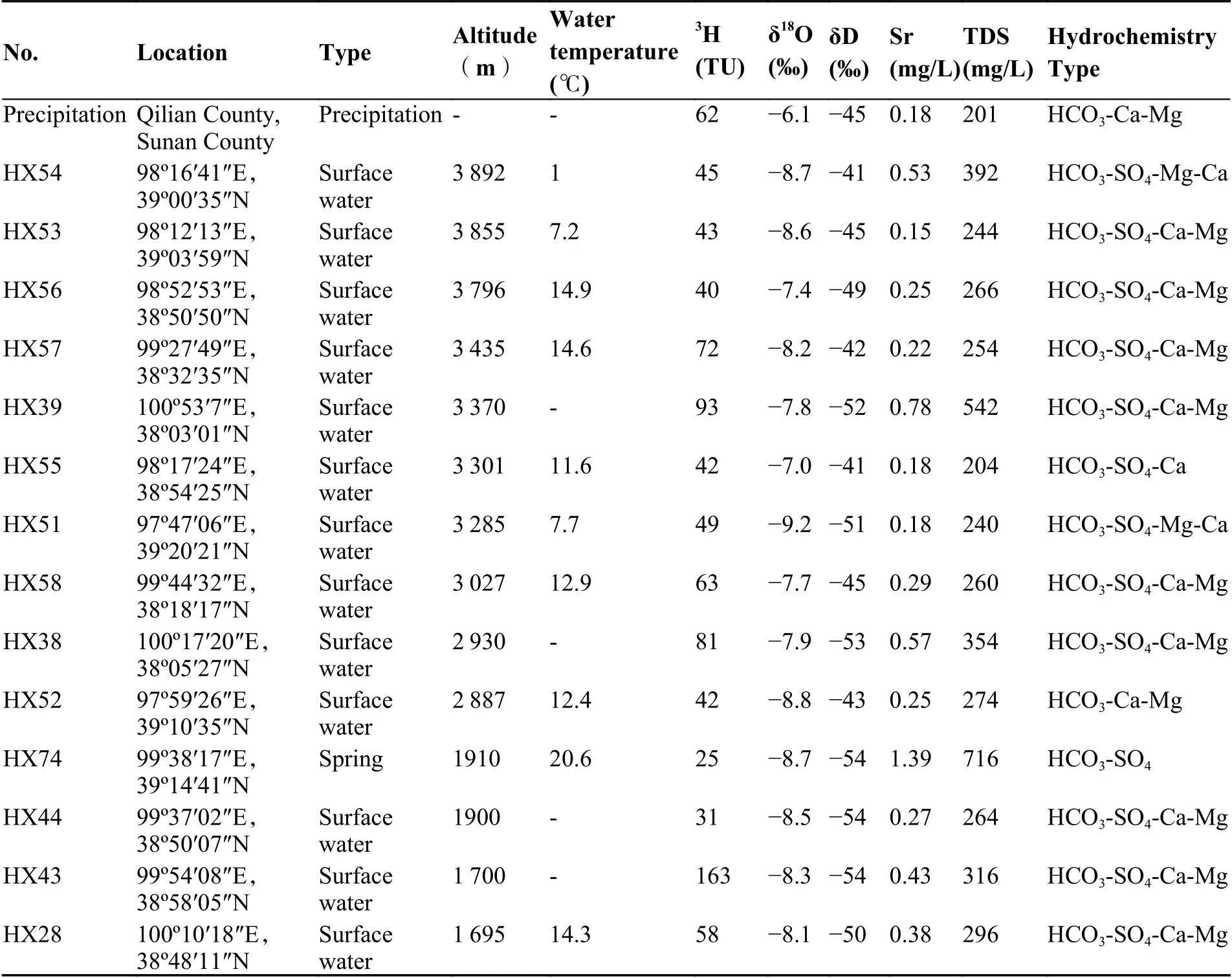
Table 1 Isotope data for water samples in the Qilian Mountains
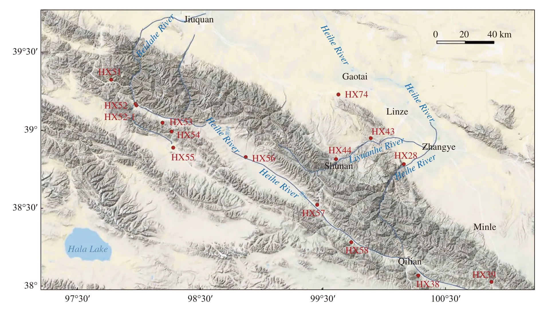
Fig.1 Location of sampling sites in the source area of the Heihe River
3 Results and discussions
3.1 Hydrochemical indications
Due to the relatively weak evaporation in the mountainous area,the TDS of surface water is less than 1 g/L and ranges between 0.3-0.7 g/L.pH value ranges from 7.7-8.1,Sr concentration is in the range of 0.11-0.78 mg/L.The hydrochemistry of surface water is HCO3-SO4-Ca-Mg type.The relative concentration of calcium ions and bicarbonate ions decreases and that of magnesium ions and sulfate ions increase from upstream to downstream,forming HCO3-SO4-Ca-Mg water with a TDS of 0.4 g/L at the outlet of the mountain.The melt water is HCO3-SO4-Ca-Mg type with the TDS of 392 mg/L and Sr concentration of 0.27 mg/L.The atmospheric precipitation is HCO3-Ca-Mg type with the TDS of 163 mg/L and Sr concentration of 0.11 mg/L.Springs emerge from riverbeds and depression springs emerge from the mountain are both HCO3-SO4-Ca-Mg type with the Sr concentration of 1.39 mg/L and TDS of 716 mg/L.
Surface runoff is the mixture of waters from different sources.It can be inferred from the samples collected from the western tributary of Heihe River that TDS increases along the flow path from 254-266 mg/L (HX56,HX57,HX58) to about 296 mg/L (HX28),and Sr concentration elevates from 0.22-0.29 mg/L to about 0.38 mg/L at the outlet of the mountain.As evaporation is weak and runoff is fast in mountainous areas,the impact of evaporation and dissolution of minerals on hydrochemistry is minimal.Therefore,the changes in hydrochemistry mainly reflect the mixing effect of groundwater and melt water.
3.2 Isotopic indications
Despite limited tritium data for precipitation in the Qilian Mountains,available data from two isotope monitoring stations in Qilian and Sunan suggest that tritium contents of precipitation vary seasonally,higher in late spring and early summer and lower in winter and autumn.The highest tritium levels reached 125-167 TU in 2001 in Sunan and Qilian and the weighted average was 62 TU in precipitation.Tritium contents in melt water,surface runoff,and springs are 46 TU (Nie et al.2005),40-93TU,and 25TU,respectively.Overall,the order of Tritium contents in different sources of water is as follows,precipitation > surface runoff >melt water > groundwater.Surface runoff samples were collected in the west tributary of the Heihe River (HX53,HX54,HX56) at an elevation of above 3 800 m,containing 40-45TU of tritium,which was close to that of melt water,indicating a significant proportion of melt water.Surface runoff samples collected below the elevation of 3 400 m (HX57,HX55,HX51,HX58,HX38,HX28) contained 42-81TU of tritium,reflecting the increased proportion of precipitation recharge.
Regarding the stable isotopic composition of precipitation in the Qilian Mountains,Zhao et al.(2011) collected precipitation samples of individual rainfall events at the meteorological stations in the upper reaches of the Heihe River at Yeniugou (June 2008 to February 2009 and June to September 2009) and at the Dayekou (September to November 2008) and obtained the stable isotopic composition of precipitation in the source area,Y = 7.16 X + 5.39 at Dayekou and Y = 7.64 X + 12.396 at Yeniugou.The δ18O and δD values of surface runoff of this study range from -9.2‰to -7‰ and -54‰ to -41‰,respectively,while the δ18O and δD values of melt water have lower variability,with mean values of -14.1‰ and-87‰,respectively (Nie et al.2005).The δ18O and δD values for groundwater vary by -8.7‰and -54‰,respectively.Overall,isotopes of precipitation,melt water and groundwater vary significantly,with the ranking of δ18O and δD being in the order of precipitation > surface runoff> groundwater > melt water.
The relationship between δ18O and δD for surface runoff (Fig.2) shows that most samples fall near the GMWL line,indicating the isotopic composition of recharged water.Samples from the western areas with high altitude (HX51,HX52,HX53,HX54,HX57) fall above the isotopic composition of precipitation due to the isotopic fractionation effect of ice and snow sublimation.In these samples,the proportion of melt water is higher than that others.
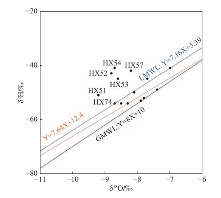
Fig.2 δ18O and δD relationships for surface runoff in the Heihe River source area
In summary,the isotopes of precipitation,melt water and groundwater differ markedly,with δ18O values being in the order of precipitation > melt water > groundwater.The surface water in the Beidahe River is close to that of melt water,and the isotopic signature of surface water in the Heihe River is close to that of precipitation.
3.3 Contributions of runoff components
Surface runoff in the Heihe River source area is derived from precipitation,melt water and groundwater.In Fig.3 (δ18O-TDS or δ18O-Sr),the surface runoff samples all fall in the mixing zone of precipitation,melt water and groundwater,supporting the above inference of surface runoff components.and the contribution of these components can be estimated by the isotopic and hydrochemistry component relationships.
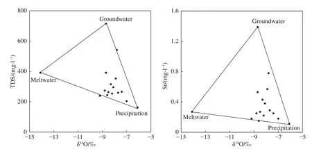
Fig.3 Three end-member mixing diagrams for Surface Runoff in the Qilian Mountains
Estimating the proportions of three-component mixing in a sample needs three mass balance equations (Clark and Fritz,1997),(1) the mass balance of the fractions of end-member waters;(2)the mass balance equation for δ18O and (3) for conservative solutes (Sr-concentration).

Where:fm,fg,andfpare the fraction of melt water,groundwater and precipitation in surface runoff samples,respectively.
The fraction contributions of each component can be quantified by solving these mass balance equations:


Using the above equations,the contributions of precipitation,melt water and groundwater in surface runoff samples were calculated (Table 2) based on the isotopic and chemical data of the different water sources (Table 3).Results show that melt water accounts for 10%-36% (25% on average),precipitation 41%-86% (63% on average) and groundwater 2%-39% (12% on average) of the runoff in the source area of Beidahe River.Melt water accounts for 4%-24% (15% on average),precipitation 44%-77% (64% on average) and groundwater 6%-52% (21% on average) of the runoff in the source area of Heihe River.
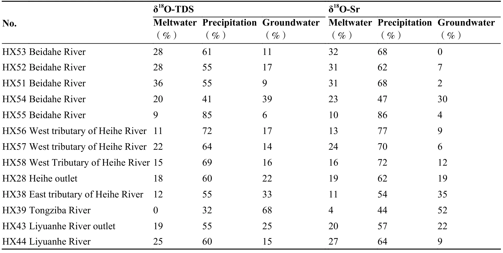
Table 2 Surface runoff composition in mountainous areas

Table 3 Hydrochemistry and isotopic characteristics of water sources in mountainous areas
In summary,melt water accounts for an average of 15%-25% of the runoff in the headwater area of the Heihe River basin,precipitation accounts for 59%-64% on average and groundwater accounts for an average of 12%-22%.Melt water accounts for 18% of the runoff at the outlet of Heihe River,precipitation 60%,and groundwater 22%.At the outlet of Liyuanhe River,melt water from the accounts for 19%,precipitation 55%,and groundwater 25% (Table 4).

Table 4 Characteristics of average surface runoff components
4 Conclusions
(1) The isotopic signature of water combined with hydrochemistry is one of the most effective methods to identify the sources and components of surface runoff and an important technical tool for assessing the water transformation in the basin,providing valuable information for water resource management in the basin.
(2) Isotopic studies of natural water bodies indicate that runoff from the source area of the Heihe River consists of mountain precipitation,melt water and groundwater.In the process of surface runoff generation in mountainous areas,meltwater contributes 15%-25%,precipitation contributes 59%-64%,and groundwater contributes 12%-22%.Atthe outlet of Heihe River,the meltwater accounts for 18%,the precipitation accounts for 60%,and the groundwater accounts for 22% of the runoff.
Acknowledgments
This research has been supported by the China National Key R&D Program (No.2017YFC04 06100).
杂志排行
地下水科学与工程(英文版)的其它文章
- Stable chlorine isotopic signatures and fractionation mechanism of groundwater in Anyang,China
- Spatial distribution characteristics and main controlling factors of germanium in soil of northern Dabie Mountains,China
- Identification of groundwater potential in hard rock aquifer systems using Remote Sensing,GIS and Magnetic Survey in Veppanthattai,Perambalur,Tamilnadu
- Effect of groundwater on the ecological water environment of typical inland lakes in the Inner Mongolian Plateau
- Geoelectrical survey over perched aquifers in the northern part of Upper Sakarya River Basin,Türkiye
- Evolution of the freeze-thaw cycles in the source region of the Yellow River under the influence of climate change and its hydrological effects
