Spatial distribution characteristics and main controlling factors of germanium in soil of northern Dabie Mountains,China
2022-12-21QiuyaoDongJiaoXiangChaoSongPanWangHaotianWenMingjiangYan
Qiu-yao Dong,Jiao Xiang,Chao Song*,Pan Wang,Hao-tian Wen,Ming-jiang Yan
1 Institute of Hydrogeological and Environmental Geology,Chinese Academy of Geosciences,Shijiazhuang 050061,China.
2 Key laboratory of Quaternary Chronology and Hydro-Environmental Evolution,China Geological Survey,Zhengding 050083,Hebei,China.
3 107 Geological Team,Chongqing Bureau of Geology and Minerals Exploration,Chongqing 401120,China.
4 School of Earth Science and Resources,China University of Geosciences,Beijing 100083,China.
Abstract: With the increasing application of germanium (Ge) elements in modern industry,military and medical health industries,especially with the growing demand for Ge-rich agricultural products,the study of Ge-rich soil has become particularly important,but the enrichment pattern and control factors of Ge-rich soil are still not well understood due to the high dispersion and high migration of Ge-rich soil.In this paper,495 surface soil (0-20 cm) and 149 deep soil (150-200 cm) samples were collected from the northern foothills of Dabie Mountain using a double-layer grid layout,and the spatial distribution and enrichment characteristics of Ge were studied by high-resolution method,and the controlling factors affecting the distribution of Ge-rich soil was analyzed by geo-statistics and spatial analogy.The results show an average Ge content of 1.34 mg/kg for the surface and 1.36 mg/kg for the deep soil.In the assessment grade classification of surface and deep soil for Ge,the abundant and sub-abundant grades account for 37.97%and 31.70%,respectively,covering 752 km2 and 634 km2.Surface Ge-rich regions are distributed in concentrated strips in the north-central part of the studied region,and there is no clear pattern in the spatial distribution of deep soils.In the areas under study,such as Fenlukou,Dingji,and Jiangjiadian,the surface soil is very rich in Ge and has a high enrichment factor,which is valuable for agricultural development.In surface soils,river deposits and shallow metamorphic rock parent materials have the highest content of Ge,while in deep soils,the highest content has been found in the parent material of moderately acidic rock.Both surface and deep soils have the highest Ge content in purple paddy soils and plain areas.The source of Ge in the soils of the study area is most influenced by the lithology of the soil-forming parent material,while the distribution of Ge in the surface soils is jointly influenced by pH,SiO2,TFe2O3,and Al2O3 in the soil.This study has implications for understanding the enrichment pattern of Ge in soil and its controlling factors as well as for the development of Ge-rich agricultural products.
Keywords: Germanium;Soil;Enrichment feature;Distribution characteristics;Influencing factors
Introduction
Recently,with the application of germanium (Ge)in high-tech (Liu,1984;HöLL and Kling,2007),industrial (Tao et al.1997;Wolf et al.1978),military (Taylor and Mclennan,1985;Haller EE,2006;Rosenberg,2009) and medical (Zhu and Lin,2000) fields,the development of Ge in soil has become a trend for industrial and agricultural development.However,the extremely high dispersion and high migration capacity of Ge in soil make its spatial distribution vary greatly,and the controlling factors are complex and diverse,so its enrichment pattern and controlling factors are still not very clear (Wich and Heilmeier,2016).Therefore,it is important to study the spatial distribution characteristics of Ge in soil.In addition,the medical and health functions of Ge-rich agricultural products (Zhu and Lin,2000) have drawn attention to the related sectors .The amount of Ge in the soil affects the growth of crops and also the amount of Ge in fruits (Shen and Xia,1997;Sun et al.2020;Liu et al.2015).Therefore,the investigation and evaluation of germanium in arable land and the study of its spatial characteristics and its influencing factors will contribute to the development of Ge-rich agricultural products.
The distribution of Ge in soil is spatially variable in China,with higher concentration in the southwest (Hong and Kong,2021;You et al.2020;Mu,2001) and coastal areas (Liu,2020;Duan et al.2020),intermediate concentration in northern(Sun et al.2020),central (Dong et al.2022) and northeastern (Li and Wang,2021) areas,and lower concentration in the western area (Yuan et al.2019;Zeng et al.2017).The factors influencing the Ge content of soils in different regions also differ significantly.Wei (2021) found that 37.2%of the arable land was Ge-rich in Zunyi city of Guizhou,with the main reason being the unique local lithology and organic matter content.Hong Tao found in Guangnan of Yunnan Province that 60% of the arable land was Ge-rich,concentrated in karst areas,which included a combination of land use practices,soil parent rocks,and landform types (Hong et al.2021).Yu et al.(2021) had an estimate of 1 559.8 km2of Ge-rich soils in Nanchuan of Chongqing,which is highly correlated with the soil-forming parent material,organic matter and heavy metals.
At present,investigations on Ge-rich soil are mostly concentrated in southwestern China,while in Liuan of Anhui Province,which is located at the northern foot of Dabie Mountain,with a superior natural condition and served as an important grainproducing area in China,the distribution and the main controlling factors of the Ge-rich soil are still not very clear.This study takes full advantage of the topography,soil-forming matrix and soil type in the study area,and explores the distribution characteristics and main controlling factors of Ge in soil of the region.It is expected that the result of this study help to enhance the understanding of Ge and related geochemical laws,provide a reliable scientific basis for the local government to scientifically utilize Ge-rich arable land resources,develop special agricultural products and take targeted measures in poverty alleviation.
1 Study area
The study area is located in Yu’an District,west of Lu’an City,which is in the central and western part of Anhui Province,at the northern foot of Dabie Mountain.The geographical coordinates are between 31.45°-32.07°N and 116.00°-116.54°E.The study site is 70 km from Hefei,the capital of AnHui province,covering an area of 2 000 km2(Fig.1).The average annual rainfall is between 900-1400 mm,with large interannual variations and uneven rainfall seasons,which are more in spring and summer and less in autumn and winter.The area is rich in water resources.The upstream of Pihe River,a tributary of the Huaihe River,flows across the area and is home to Mozitan and Fuziling reservoirs,as well as part of the Xianghongdian reservoir.The terrain of the study area is low and gentle from southwest to northeast,with hills and woodlands at the foot of the northern Dabie Mountains in the southwest,and large plains and a few basins in the south (Fig.1).The parent material is mainly Quaternary sediments,and the soil type is mostly yellow-brown loam and rice soil.The major crop is rice,and corns are also planted in a few areas.

Fig.1 Location of the study area and distribution of sampling sites
2 Methodology
2.1 Sample collection and processing
Sample collection was carried out strictly in accordance with the working methods for soil geochemical sample collection and deployment in theMultipurpose Regional Geochemical Survey(1:250 000)(DZ/T0258-2014).In order to study the impact on soil geochemistry by human activities and natural conditions at the same time,this study used a two-layer grid layout to collect surface (0-20 cm,controlled by human activities,etc.) and deep soil (150-200 cm,controlled by natural background) samples respectively.For surface soil measurement,a 1:50 000 topographic map was used as a continuous numbering unit.Sampling density of 1 site/km2with a depth of 0-20 cm was adopted.Sampling grid was square with the size of 4 km2(2 km × 2 km).,Garbage piles,newly accumulated soil,obvious point contamination of land and ridge have been avoided,and the sampling site was over 100 m away from the main highway and railroad.Based on the above sampling rules,a total of 495 surface soil samples were collected.For deep soil measurement,a 1:100 000 topographic map was used as a continuous numbering unit.The same sampling density but a bigger sampling grid of size 16 km2(4 km × 4 km)with a depth of 150-200 cm was adopted.A total of 149 soil samples were collected.Each sampling grid is divided into four (1 km2for surface soil and 4 km2for deep soil) cells,numbered sequentially from west to east and from north to south (Fig.2).
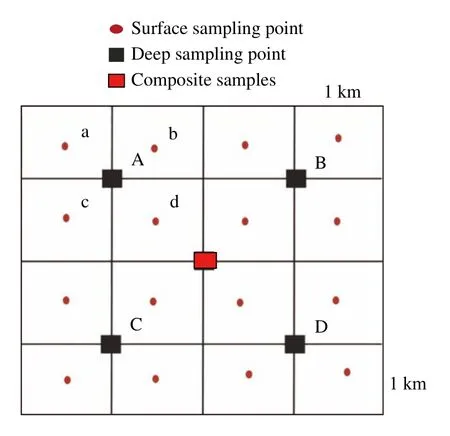
Fig.2 Location of sampling sites in the study area
Soil samples were naturally dried and all passed through a 20-mesh nylon sieve.
2.2 Analysis and testing
The measured index of soil samples included pH,Ge,SiO2,Al2O3,TFe2O3,and organic matter,and the testing equipment and detection limits of each index are shown in Table 1.The analysis and testing were carried out at the Hubei Provincial Geological Laboratory,and all the indexes met or were better than the technical standard of the China Geological Survey,which are required by Multipurpose Regional Geochemical Survey (1:250 000)(DZ/T0258-2014).

Table 1 The test results
2.3 Data processing
Descriptive statistical analysis,normal distribution test,and Pearson correlation analysis were done using SPSS 19.0 and Excel 2010.The germanium content distribution maps for soils at different depths as well as the enrichment maps were done in ArcGIS 10.6.
3 Results and discussion
3.1 Characterization of Ge in soils
The distribution of Ge content in soils in the study area is shown in Table 2.For the 495 surface soil samples,the Ge content varied from 1.01 mg/kg to 1.80 mg/kg,with a mean value of 1.34 mg/kg and a coefficient of variation of 10.40%.The histogram of the frequency distribution of Ge in soils basically follows a normal distribution (Fig.3),and Ge content in both surface and deep soil is of weak spatial variability.The content of Ge in surface soils(1.34 mg/kg) is lower than that in coastal area and southwestern karst regions,such as 1.648 mg/kg in Guangnan of Yunnan province,1.59 mg/kg in Changshan of Zhejiang province,and 1.60 mg/kg in Xingren of Guizhou province,but it is close to the background value of Ge content in Chinese Alayer soils (1.3 mg/kg) and higher than that in the western part of Ruoqiang region of Xinjiang (1.16 mg/kg),and Qushui of Tibet (1.27 mg/kg).The distribution of Ge in soils is spatially variable in China,and the study of this variability is of great practical importance for agricultural production.
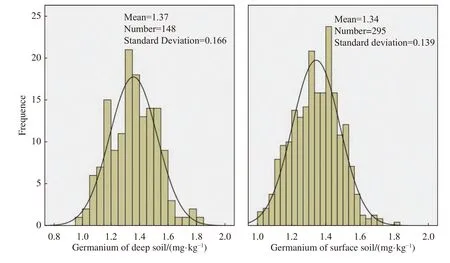
Fig.3 Frequency distribution of Ge content in soils at different depths in the study area
3.2 Spatial distribution characteristics of Ge in soils
According to the national-provincial/provincialdistrict land quality evaluation criteria for the classification of nutrients such as calcium,magnesium and sulfur were given in the Multipurpose Regional Geochemical Survey (1:250 000) (DZ/T 0258-2014) (Table 3),the Ge content in the surface layer (0-20 cm) of the study area was divided into five grades,i.e.abundant,sub-abundant,medium,sub-lack and lack,the percentage of each grade is shown in Table 3 as follows: 13.33%,24.64%,25.05%,20.20% and 16.69%.The spatial distribution of Ge concentration in the surface and deep soils was generated in ArcGIS (Fig.4),and the distribution patterns of Ge content in the surface and deep soils are very different.The distribution of Ge in the surface soil is geographically concentrated,with the abundant grade (>1.50 mg/kg)distributed in a stellar pattern in the northeastern part of Dingji Town,the junction of Fenlukou Town and Shizigang Town.The sub-abundant grade (>1.40 mg/kg) was distributed in strips in the area of Shizigang town-Fenlukou town-Jiangjiadian town-Dingji town-Guzhen in Northwest Wanban district.Ge content in the low hills and hilly areas of the southeastern hills is significantly lower,and the sub-lack grade (<1.30 mg/kg) is mainly distributed in the south of the study area of Shipodian Town-Dushan Town-Xihekou-Qingshan Town-Subu Town-Hanbaidu Town and Shanwang Town-Xin’an Town in the northeast of the study area.The lack grade (≤1.20 mg/kg) was spora-dically distributed at the junction of Hanbaidu town and Subu town,as well as the south-central part of Xihekou town and the southern part of Qingshan town.

Table 2 Statistical analysis of soil Ge content in the study area

Table 3 The national-provincial/provincial-district land quality evaluation criteria for the classification of nutrients such as calcium,magnesium and sulfur and the Ge concentration percentage in the study area
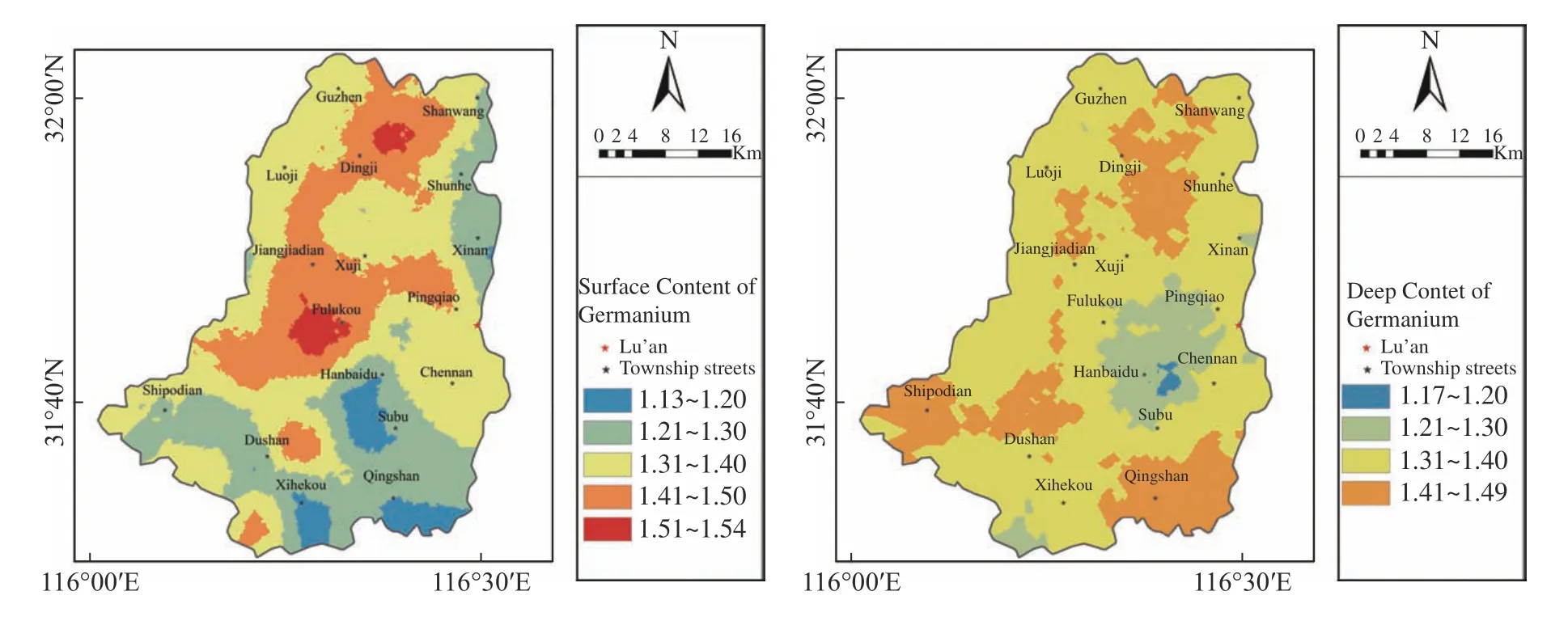
Fig.4 Spatial distribution of Ge content in surface (left) and deep (right) soils in the study area
The distribution of the five grades of Ge in the deep soil were as follows,15.70% for abundant,16.00% for sub-abundant,22.40% for medium,19.70% for sub-lack and 26.10% for lack,respectively.The spatial distribution of Ge in deep soils had no obvious strip pattern and was concentrated in scattered blocks in the study area.The subabundant grade is sporadically distributed at the junction of Shipodian town,Shizigang town and Dushan town,Qingshan town,Dingji town and Shunhe town.The sub-lack grade is mainly concentrated at the junction of Hanbaidu town,Fenlukou town and Chengnan town,where a small part of the eastern Hanbaidu town falls in the class of lack grade.
3.3 Enrichment characteristics of germanium in soils
The ratio of element content in the surface soil to that in the deeper parent soil is called the enrichment coefficient (Liao et al.2005),and the combination of “two-layer soil” analysis can evaluate the enrichment of such elements in a certain thickness of soil and characterize the change or modification of the secondary environment (anthropogenic influence) relative to the primary environment (deeper natural environment).In this study,one combination sample from the 4 km2grid of surface soil corresponds to one combination sample from the 16 km2grid of deep soil,and a total of 495 surfaceto-deep ratios were obtained.Statistical analysis showed that the enrichment coefficient of germanium (surface soil Ge content/deep soil Ge content)in the soils of the study area ranged from 0.66 to 1.53,with a mean value of 1.01.Based on previous studies (Duan et al.2020) and considering the actual situation in this study area,the enrichment coefficients were classified into <0.85,0.85-1.05,and >1.05 corresponding to three grades of lack,background,and enrichment,respectively (Table 4).

Table 4 Enrichment classification of germanium in soils of the study area
Interpolation analysis in ArcGIS shows that there is no obvious zonal distribution of germanium enrichment (Fig.5).The northwestern part of the study area has more plains and a few basins with thick soil layers,while the southeastern part of the study area has low mountains and hills with thin soil layers.37.90% of the soil in the study area falls in the enrichment grade,mainly distributed in the middle of the study area.Sub-abundant grade mainly concentrated in the middle area of Chengnan Town,Fenlukou Town and Xuji Town,the west part of Shizigang,and the Northern half of Dingji Town,which has a high prospect of development.46.97% of the soil in the study area falls in the background grade,where the surface content of germanium was medium or below,distributed in blocks to the north and south,indicating that the germanium content is weakly affected by anthropogenic activities.15.12% of the soil in the study area falls in lack grade and distributed in a southeast-north-west direction in Qingshan Town,Shibanqiao Town,Dushan Town,and Shibadian Town.
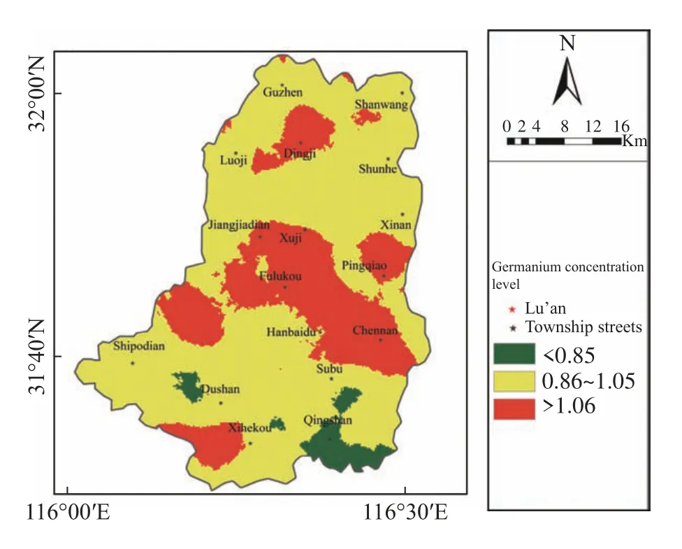
Fig.5 Spatial distribution of germanium enrichment in soils of the study area
3.4 Factors influencing germanium content in soils
Soil type,soil-forming parent material,and topography are the main factors affecting germanium content in soil (Mu,2001;He et al.2016;Xu,2006).Since Ge is easily associated with metals in soils and the organic matter content also affects the distribution of organic Ge,the physicochemical properties are also important factors affecting the Ge content in soils.
3.4.1 Soil-forming parent material
The parent material is the basis of soil formation.The concentration of trace elements in the soil is related to the parent material (Loell et al.2011),and the difference in the parent material will lead to large variations in soil properties (Xu,2006;Dong et al.2020).The lithologies exposed in the study area are diversified and complex,mainly Quaternary alluvium from Fenglezhen Formation and Qizui Formation.The main lithologies are Fe-Mn-bearing structural silt-clay,sub-clay,sandy clay,fine sand,silt,gravel,and a small amount of shale,gneiss,purple sandstone weathering material,and flooding material.
Five major parental sources were identified according to the lithological grouping (Table 5,Fig.6).The river alluvial accounts for 74.9% of the total area and is distributed in continuous blocks in the northern part of the study area,followed by the red clastic weathering material accounting for 17.5% and distributed in the southwestern part.
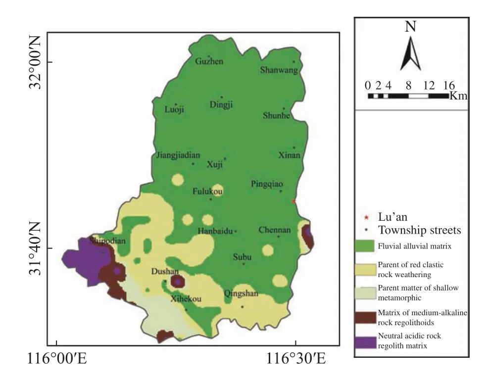
Fig.6 Distribution of soil parent material in the study area
The results of analyzing the distribution of surface and deep content of Ge in different parent materials (Table 5) show that the distribution of mean Ge content in the surface layer follows the order of river impact parent material = shallow metamorphic > red clastic rock > medium acidic rock > medium alkaline rock.While the deep soil Ge content follows the order of medium acidic rock > red clastic rock > river impact parent material > medium alkaline rock > shallow metamorphic rock.The distribution of Ge content in deep and surface soil varies widely among parent materials,and the largest difference in mean value is found between acidic rocks and clastic rocks,mainly due to fertilization and farming practices.As for the deep soil,the highest content of Ge in the medium acidic rocks and clastic rocks were distributed in the mountainous areas in the southwestern part of the study area,with mean values of 1.50 mg/kg and 1.45 mg/kg,respectively,and the lithological development of these two parent materials was dominated by shale and sandy mudstone.Studies have shown that soils with a high percentage of mudstone tend to have a high germanium content (Mu,2001) and that the mud,carbonaceous,and organic matter rich in shale enhances the adsorption of germanium,resulting in germanium enrichment in shale (Onishi and Hiroshi,2006;Burton et al.1959).The content of Ge in deep soils is the least in shallow metarmorphic rocks and medium alkaline rocks.In Anhui Province,shallow metamorphic rocks are divided into two types of volcanic rocks and sedimentary rocks.Medium alkaline rocks are mostly igneous,and volcanoes consume a lot of Ge during burning (Wolf et al.1978;Franco and Marcantonio,1998;Murnane and Stallard,1990),which is the reason for its low content.In conclusion,the correlation between the soil parent material distribution and the enrichment coefficient shows that the average content of germanium in the deep soil of the study area is highly correlated with the parent material lithology.

Table 5 Distribution of soil germanium in different parent material types,soil types and topographic features in the study area
3.4.2 Soil type and Topography
The soil in the study area is mainly developed from the alluvium of Pi River and Xiashu loess.The river bend area in the northwestern part was formed from the weathering of rocks in the Dabie Mountains and deposited by the long-term scouring of water from the Pi River,which has become hydragric paddy soils and fluvo-aquic soil through long-term cultivation.The soil cover is thick,can be characterized as deeply cultivated,highly fertile,light to medium loam,and neutral to acidic.The southeastern part is mainly composed of hills,intertwined with humps and clos,formed by ancient geological processes of flooding and alluvium.The surface has been eroded and denudated over a long period of time,forming yellow brown soil,purple paddy soil and paddy soil that has been nutritionally modified by long-term cultivation.(Fig.7).The spatial distribution maps of germanium in different soil types at surface and deep layers were overlaid and analyzed,and the results showed that the spatial distribution of germanium in surface soils had high correlation with soil types,while the distribution of germanium in deep soils was not significantly correlated with soil types.The germanium content in both deep and surface purple paddy soils was significantly higher than that in other soil types,the second highest was found in paddy soils.The parent rocks of purple paddy and paddy soils are medium-acidic rocky weathering material,and the lithology is dominated by shale ahnd sandy mudstone,which is responsible for its highest Ge content.Areas covered with yellow brown soil and fluvo-aquic soil have low germanium content.Yellow brown soil is mainly developed in granite and granite gneiss,which has a large degree of soil leaching,causing the loss of Ge.In contrast,fluvo-aquic soil is generally influenced by groundwater and has low organic matter content resulting in a low Ge content.

Fig.7 Distribution of soil types in the study area (left) and topographic map of the study area (right)
The study area is located in the central part of Lu’an City,Anhui Province,and is divided into four topographic landform types: Mountains,hills,plains and basins (Fig.7).The topography is dominated by plain,accounting for 71.0% of the total area,followed by hills accounting for 15.4%.The major local agricultural production is rice.Except for the hilly areas,average Ge contents are similar in surface and deep soils in most landscape types.The maximum difference in germanium content between surface and deep soils in hilly landscapes was 0.13 g/kg (Table 5).For the past two decades vegetation in the hilly areas has been severely damaged by crop planting,causing serious soil erosion in the surface layer (Liu,1984),which is the reason why the Ge content of surface soils is significantly lower than that of deep layer.The combined Ge content in both surface and deep soil in the plain area is higher than in the basin area,which is due to the loss of Ge4+from the basin soils caused by the action of running water and scouring.
In conclusion,both soil type and topographic features have some influence on the distribution of Ge in soils.However,in terms of enrichment coefficients,the effects of soil type and topographic features on the distribution of germanium in soil are not significant compared with natural causes of Ge deposit.
3.4.3 Physicochemical property related analysis
According to previous studies,germanium exhibits pro-Fe,pro-rock,pro-Cu and pro-organic properties in the environment (Bernstein,1985;HöLL et al.2007),and germanium in soils is mainly associated with minerals or ores containing Si,C,Zn,Cu,Fe,Sn and Ag (Scribner et al.2006;Song et al.2022).From bedrock weathering to loam formation,germanium adsorbs to clay minerals and precipitates with compounds such as Fe2+and Al3+,showing strong adsorption to organic matter(Kurtz et al.2002;Scribner et al.2006;Rosenberg,2009).In this study,pH,organic matter Corg,TFe2O3,Al2O3and SiO2were selected and analyzed as the indicators of physicochemical properties (Fig.8) and correlation analysis was done between these properties and Ge in the surface and deep soils.The results are shown in Table 6.Ge in the surface soil showed a weak positive correlation with TFe2O3,Corg,pH,and SiO2,and weak negative correlation with Al2O3(P< 0.01),implying that all indicators had an effect on the germanium content of the surface soil.In contrast,the deep content of germanium was moderately positively correlated with SiO2(P <0.05) and weakly negatively correlated with Al2O3(P < 0.01).The factors affecting the distribution of germanium content in deep surface soils were different.

Table 6 Correlation analysis of germanium in soil with other elements
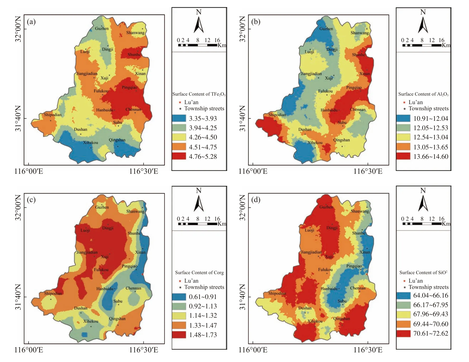
Fig.8 Distribution of single indicators of (a)TFe2O3、(b)Al2O3、(c)Corg、(d)SiO2
Germanium content is positively correlated with organic matter in soils,which is one of the main reservoirs of germanium,but the correlation coefficient is lower in the Dabie Mountain region compared to the southwestern region.Not like the case in the Dabie mountain region,Ge-rich soil in southwest China is mostly distributed in karst areas,and the difference in geomorphology and soil-forming parent material is the reason for their diverse correlation grades (Kurtz et al.2002;Wei et al.2000).The pH of soils is a combination of many chemical properties that determine,to some extent,the chemical forms and effectiveness of elements in soils.Soils with higher pH have a higher content of germanium in the water-soluble state.(Tyler and Olsson,2001).In addition,germanium can take the place of Fe in the octahedra containing Fe oxides,because Fe and Ge can form similar bond lengths with O (Bernstein and Waychunas,1987),so germanium can be immobilized into Fe oxides to get enriched.At the same time,during the leaching process of soil,Fe and Al oxides are continuously enriched,and the formation of chemisorbed surface sites will enhance the adsorption of Ge,which is the reason for the positive correlation between Ge and Fe-Al oxides.Since silicon and germanium have the same external electronic structure and very similar ionic radii,so silicate and germanate can form isostructural compounds(HöLL et al.2007),which results in a positive correlation between Ge and SiO2in soils.
In conclusion,all the five physicochemical indicators selected in this study,namely pH,organic matter Corg,TFe2O3,Al2O3,and SiO2,had mild effects on the distribution of Ge in the surface soil.Al2O3had a mild effect on the distribution of Ge in deep soil,and SiO2had a moderate effect on the distribution of Ge in deep soil.
4 Conclusion
The average Ge content in the surface soil of the Lu’an area at the northern foot of Dabie Mountain is 1.34 mg/kg,which is comparable to the background value (e) of Ge in the A layer in China,lower than that in the coastal and southwestern karst regions of China,and higher than that in the western region of China.The Ge-rich soils in the study area accounted for 37.97% of the total area,and 20.20% and 16.69% for the grade of sub-lack and lack,respectively.Among them,the abundant grade of enrichment is mainly concentrated in the towns of Lu’an City,such as Fenlukou,Dingji,and Jiangjiadian.These areas have high enrichment coefficients,which meet the requirements of green and sustainable agricultural development,and it is recommended to develop various types of Ge-rich agricultural products to increase agricultural output.
The Ge content of surface soils in the study area was the highest in the river alluvium and soils formed from shallow metamorphic rock.Ge content of deep soils was the highest in the soils formed from medium acidic rock.The spatial distribution of Ge in soils is generally less influenced by soil type and topography,and controlled by the lithology of the parent material of the soil.The distribution of surface soil is also influenced by pH,SiO2,TFe2O3,Al2O3and Corg,and the distribution of deep soil is influenced by SiO2and Al2O3.
Acknowledgements
This study was funded by the basic scientific research expense of the Institute of Hydrogeology and Environmental Geology,The Survey for Land and Resources (DD20221773-4).
杂志排行
地下水科学与工程(英文版)的其它文章
- Analytical solutions for constant-rate test in bounded confined aquifers with non-Darcian effect
- Evolution of the freeze-thaw cycles in the source region of the Yellow River under the influence of climate change and its hydrological effects
- Geoelectrical survey over perched aquifers in the northern part of Upper Sakarya River Basin,Türkiye
- Effect of groundwater on the ecological water environment of typical inland lakes in the Inner Mongolian Plateau
- Identification of groundwater potential in hard rock aquifer systems using Remote Sensing,GIS and Magnetic Survey in Veppanthattai,Perambalur,Tamilnadu
- Stable chlorine isotopic signatures and fractionation mechanism of groundwater in Anyang,China
