Structural characteristics and hydrocarbon accumulation in Bashituo area, Tarim Basin
2021-09-10GUOYiruYUMinghuiLIZongyuBAYANXianmutihanJIAYudongandWANGXinyu
GUO Yiru, YU Minghui, LI Zongyu, BAYAN Xianmutihan, JIA Yudong and WANG Xinyu
1. College of Earth Sciences, Jilin University, Changchun 130061, China;2. Institute of Geological Survey of Jilin University, Changchun 130061, China;3. Yakela Gas Production Plant, Sinopec Northwest Oilfield Company, Kuche 842017, Xinjiang, China
Abstract: According to well logs, core, seismic and other geological data, the authors studied the tectonic evolution stages, trap formation stages, fault and fracture development in the Bashituo area, and furthermore, analyzed the time of hydrocarbon accumulation, hydrocarbon migration pathways and related controversial issues in the study area. It is believed that the tectonic evolution in the study area can be divided into three stages, namely Late Hercynian, the Early Himalayan and the Late Himalayan. In the Late Hercynian, tectonic movement led to folding and faulting, resulting in the embryonic form of anticlinal traps. In the Early Himalayan, affected by both tectonic movement and transformation, deep faults reactivated and cut through the Lower Tertiary strata. After the Early Himalayan tectonic movement, faulting stopped and no vertical migration pathway was available. Then hydrocarbon migrated laterally along the sand bodies in the Bachu Formation and accumulated in the Carboniferous reservoirs. However, the Carboniferous accumulation was formed late, and the tectonic movement was weak at the Late Himalayan, and faults were underdeveloped, so the reservoirs in the deep Bachu Formation were not disturbed.
Keywords: Tarim Basin; Bashituo; hydrocarbon accumulation; structural characteristics; tectonic evolution
0 Introduction
The Bashituo area is one of the regions that had been targeted foroil and gas exploration in the earlier stage in the Tarim Basin, and is considered with great exploration potential and prospects. In recent years, some scholars have studied the sedimentary system, paleogeographic characteristics, hydrocarbon accumulation and reservoir prediction in this area (Tanetal., 2007; Wangetal., 2019; Liuetal., 2004). How-ever, a great controversy has been long surrounding the formation of paleo-reservoirs in the study area. Meanwhile, with the continuous progressin the exploration in the Bashituo Oilfield, disputes have arisen, concerning the migration direction and pathway and hydrocarbon accumulation period in the study area. This paper studies the structural characteristics and hydrocarbon accumulation in the Bashituo area, which is of great significance for further understanding the hydrocarbon-bearing system in this area and promoting hydrocarbon exploration and development.
1 Geological setting
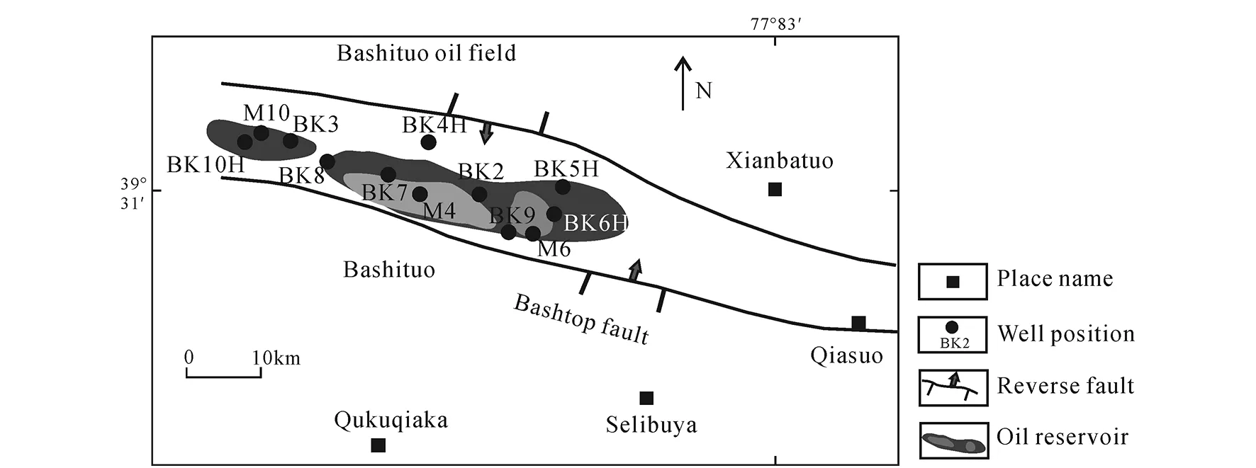
Bashituo oil and gas field is located in the Bashituo structure in the west of Bashituo--Xianbazha structural belt in the northwest of the Maigaiti slope in the Tarim Basin (Hu, 2015). The Bashituo structure is mainly controlled by the Bashituo fault, which is a NNE-dipping thrust fault of nearly EW-trending and north-to-south nappe (Mengetal., 2008). The structure, located in the hanging wall of the fault, is a long-axis anticline. The long-axis direction of the structure is consistent with the fault strike, and it is extending in the NWW-SEE direction. The structure is steep in the south wing but gentle in the north wing.

Fig.1 Geography and structural location of Bashituo area (modified from Wang et al., 2019)
2 Structural characteristics
2.1 Tectonic evolution
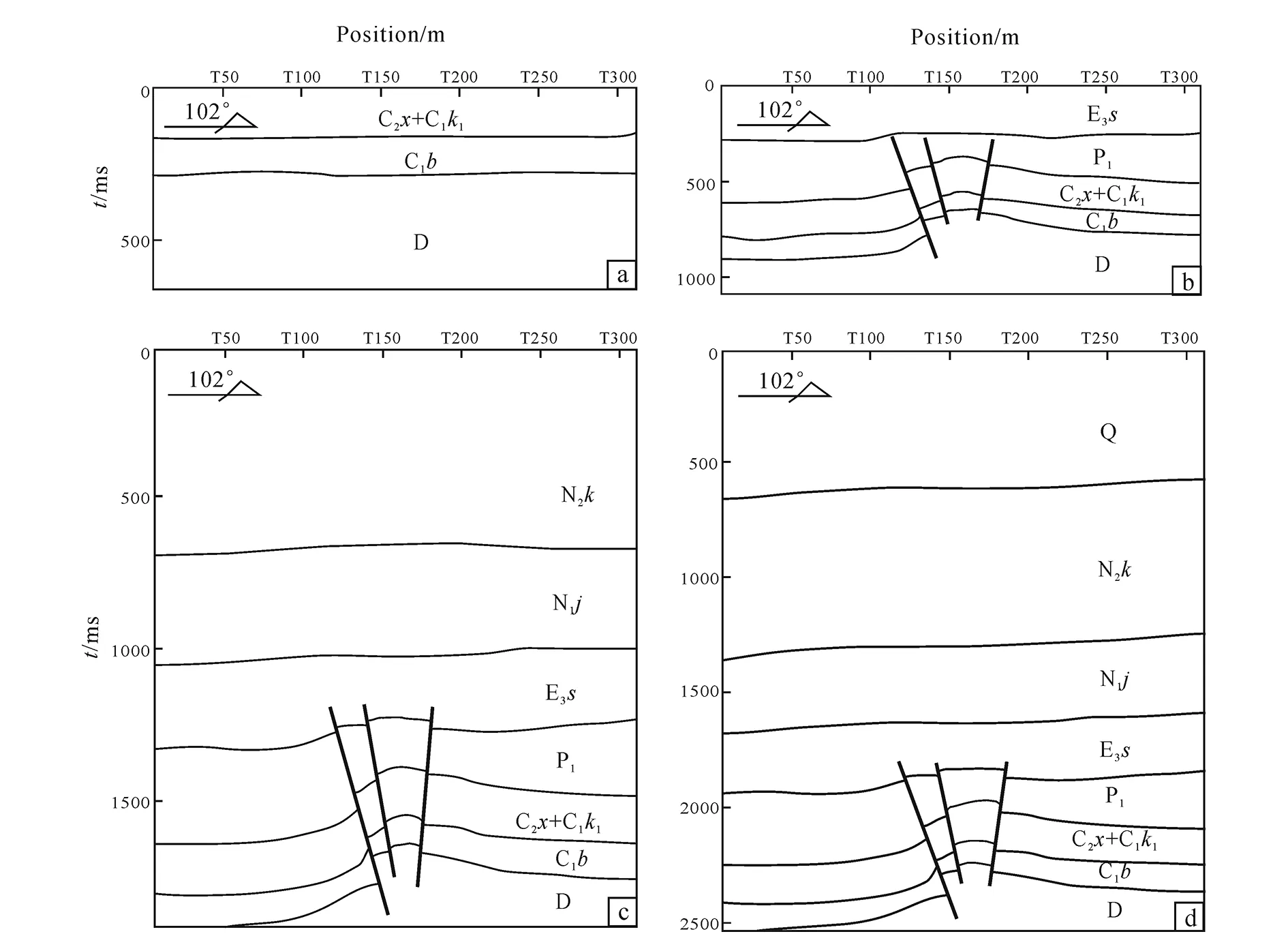
According to regional tectonic evolution and the seismic interpretation, the Bashituo structure has experienced truncation, overlapping and migration of structural high from the Carboniferous to the Tertiary. Tectonic evolutioncan be divided into three stages: the Late Hercynian, the Early Himalayan and the Late Himalayan. The three-stage tectonic movement are closely related to the reservoir development, hydrocarbon migration and accumulation, and abnormal high pressure in the Bachu Formation. The analysis based on the seismic profile of survey line L473 in the Bashituo area is presented in the following.
(1) Late Hercynian tectonic movement
The tectonic movement in the Late Hercynian lasted for a long time. The Permian strata at the axial part of the structure were heavily eroded, with Triassic (T), Jurassic (J) and Cretaceous (K) strata missing (Fig. 2a). During this period, the embryonic form of the Bashituo structure was formed, which was a long-axis anticline in the near EW-trending. Tectonic movement led to many folds, and the Bashituo fault was mainly formed in this period. To be specific, the thrust fault parallel to the Bashituo structural axis was developed during this time (Fig. 2b).
(2) Early Himalayan tectonic movement
The tectonic movement in the Early Himalayan induced numerous folds, and denuded strata were observed at the main survey line (L473). Besides, it resulted in the changes in the structural shape of the top of the Bachu Formation and in the location of structural high. This tectonic movement slightly changed the EW-trending Bashituo structure which basically kept high in the west and low in the east. During this period, the thrust fault revived, affecting the base of Tertiary strata. The faults formed in the structural plane showed small fault displacement, with few into the base of the Tertiary (Fig. 2c). The scale and shape of faults were dominated by the Early Himalayan tectonic movement.
(3) Late Himalayan tectonic movement
The tectonic movement in the Late Himalayan initially shaped the Bashituo structure, causing few faults. The late faults were underdeveloped (faulting downwards from top), and the deep faults were not activated (inactive faults in this period). Near NNE-trending shallow folds developed, which had little influence on the deep traps. The uplift in the east Bashituo structure changed the high point of Bashituo structural trap into the present pattern (Fig.2d). Then the Bashituo structural trap was generally shaped.
Overall, the Bachu Formation was deposited in the environment of an evaporation platform and a restricted platform. The early structures had been filled and flattened, and structural traps were not deve-loped. At the end of Permian, faults and folds were developed, leading to an embryonic form of structural traps, and multiple structural highs were observed. In the Early Himalayan period, the thrust fault reactivated, affecting little on the shape of the Bashituo trap. In the Late Himalayan period, all faults were inactive, and the structural highs were changed by the tectonic movement in the east.

(a) Xiaohaizi Formation at end of Permian; (b) deposition at end of Oligocene; (c) deposition at end of Cenozoic; (d) current state. Fig.2 Tectonic evolution indicated from NS L473 profile in Bashtuo area
2.2 Fault development characteristics
The Bashituo structure is located at the northwest of Maigaiti slope in the southwest depression of Tarim Basin, which is mainly composed of Selibuya-, Qunkuqiake- (Bashituo--Xianbazha-) and Yudailike faults (Mengetal., 2008).
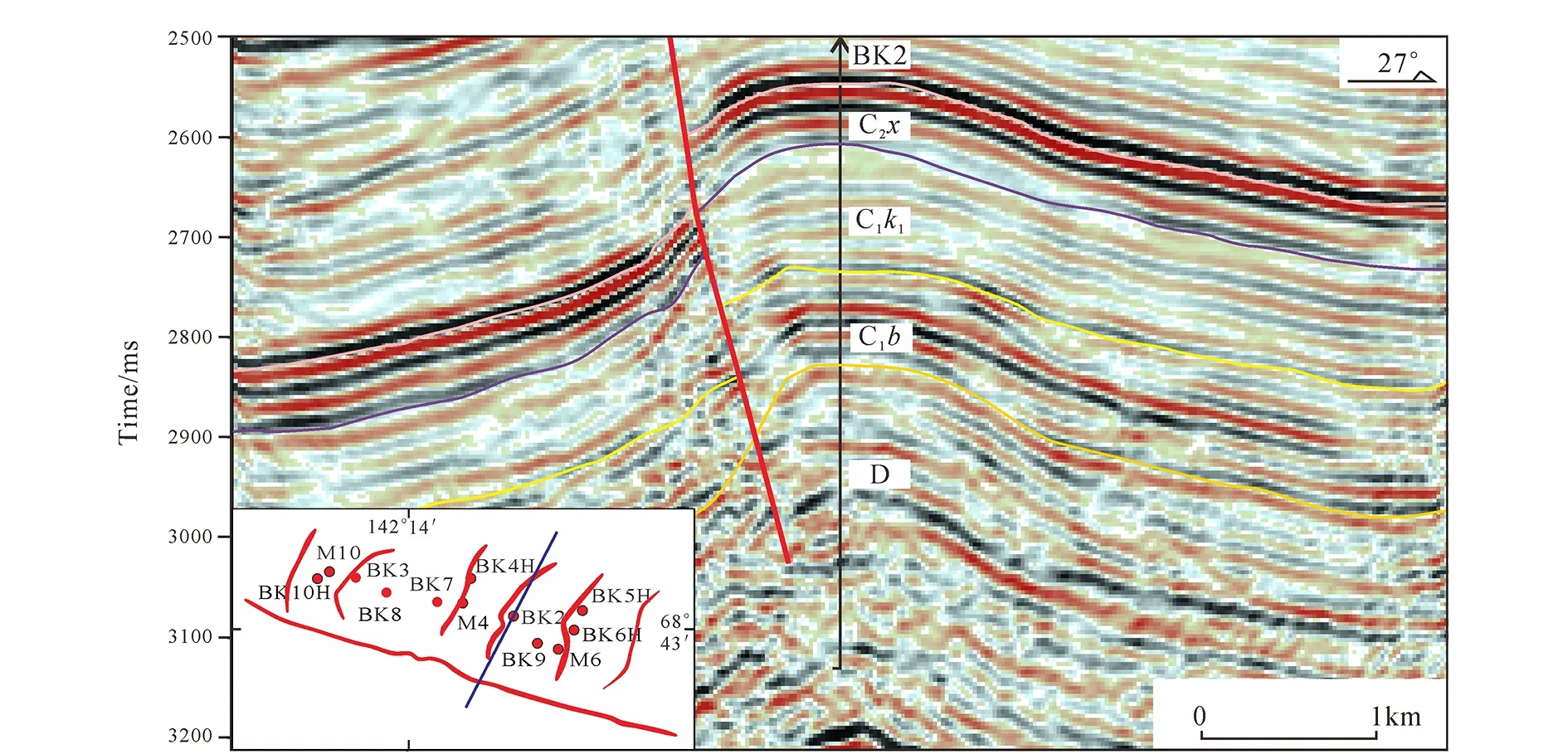
Bashituopu thrust fault is located on the south wing of the Bashituopu structure, which was formed by the NS compression in the Hercynian period. As indicated at Well BK2 in the study area, Bashituopu fault is nearly EW-trending and inclines to the north (Fig.3).
2.3 Fracture development characteristics
The original formation pressure of the Carboni-ferous Bachu reservoir in the Bashituo area was 92.05 MPa/4 700 m, and the pressure coefficient was 1.97,indicating a hydrocarbon reservoir of high-ultra-high pressure (Liu, 2014). The analysis revealed that its genesis was mainly influenced by multi-stage tectonic movement. The main development period of fractures in the study area also depended on the stages of tectonic evolution. To be specific, the tectonic movement at the end of Permian sedimentation induced the thrust fault of the Bashituo structure, the fractures and micro-fractures in the Bachu Formation. The early Tertiary tectonic movement led to revived thrust faults and the secondary development of fractures and micro-fractures, whereas the Late Himalayan tectonic movement shaped the Bashituo structure, with underdeve-loped faults and undisturbed deep faults. Fractures were not observed in the Bachu Formation during this tectonic movement.

Fig.3 Seismic profile of Well BK2 in Bashituo area
3 Analysis of hydrocarbon accumulation
3.1 Stages of accumulation
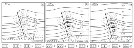
At the end of Permian, the thrust fault was active, and the Bachu Formation (C1b) was stretched to produce meshed or banded extensional fractures. At the same time, dissolution by primary hydrothermal in the karst enlarged pores and extended the extensional fractures, producing dissolved pores to form effective reservoir pore space (Fig. 4a). During the tectonic movement, Bashituo structural folds were uplifted, associated with erosion and faulting, resulting in the missing of Triassic, Jurassic and Cretaceous strata sedimentation. Hydrocarbon accumulation did not occur prior to Tertiary, otherwise, the activation of faults would cause oxidation damage to oil reservoirs, leaking of oil and gas along faults to the Permian. Oil and gas shows were not observed in the Permian, and heavy oil or asphalt was not identified in the Carboni-ferous core either, proving the late hydrocarbon accumulation and the absence of Permian paleo-reservoirs.
At the end of Oligocene sedimentation, driven by the Himalayan movement, the thrust fault continued to develop upward, together with sedimentary burial, Bachu Formation (C1b) gradually moved down to the middle of the second stage of fracture development. The second stage of fractures was generally stable, therefore, the effect of tectonic movement on extensional fractures was weak. After this tectonic movement, all faults stopped their activities, and hydrocarbon began to migrate laterally and accumulated into reservoirs (Fig. 4b).
At the end of Pliocene sedimentation, thrust faults were continuously affected by the tectonic movement during the Himalayan period and continued to move upwards. As a result, the Bachu Formation gradually moved to the bottom of the draping structure, becoming an extrusion zone. Subject to both compressive stress and overburden, light components, especially dissolved gas, overflowed into the Xiaohaizi Formation (C2x) of the overlying effective reservoir, while heavy components were reformed by catalytic cracking (Fig. 4c).

1. Stage Ⅰ extensional fracture; 2. stage Ⅱ extensional fracture 3; stage Ⅲ extensional fracture; 4. stage Ⅰ transpressional fracture; 5. stage Ⅱ transpressional fracture; 6. stage Ⅲ transpressional fracture; 7. stage Ⅰ meshed fracture; 8. stage Ⅱ meshed fracture; 9. stage Ⅲ meshed fracture; 10. fault; 11. gas pay; 12. oil pay.(a) Xiaohaizi Formation at end of Permian; (2) sedimentation at end of Oligocene; (3) sedimentation at end of Pliocene.Fig.4 Development history of hydrocarbon accumulation for Bachu Formation in Bashituo area
3.2 Mechanism of hydrocarbon accumulation
At the at the end of Oligocene, Bashituopu thrust fault revived during the Early Himalayan tectonic movement, cutting through the Lower Tertiary strata, and the structure was basically shaped. After this tectonic movement, hydrocarbon began to migrate laterally to accumulate into reservoirs. As indicated from the accumulation profile across Well BK2, after the Ter-tiary strata began to deposit, the Bashituopu fault and Babei fault stopped moving, failing to serve as the longitudinal hydrocarbon migration pathways. After the tectonic movement in the Tertiary sedimentary period, Bachu Formation (C1b) was shaped into an anticline with large dip angle, facilitating to capture hydrocarbon. As such, hydrocarbon migrated laterally along the sand bodies in the Bachu Formation and accumulated in the traps at the structural high forming early primary reservoirs (Fig. 5).

Fig.5 Reservoir model of Bachu Formation in Bashituo area
4 Conclusions
(1) During the structural evolution from the Carboniferous to the Tertiary in the Bashituo area, locations of structural highs changed in three stages, and truncation was identified in the Suweiyi Formation and at the top of Permian strata. The Bachu Formation mainly experienced three stages of evolution, namely the Late Hercynian, the Early Himalayan and the Late Himalayan. In the Late Hercynian tectonic movement, folds and faults were developed. Oil and gas shows were not observed in the Permian strata, and heavy oil and asphalt were not found in the Carboniferous either. Therefore, Permian paleo-reservoirs were not developed in this area.
(2) During the Early Himalayan tectonic movement, the Bashituopu thrust fault was reactivated and cut through the Lower Tertiary strata. After this tectonic movement, the main controlling fault stopped its activity, failing to work as longitudinal hydrocarbon migration pathways. Then hydrocarbon migrated laterally along the sand bodies in the Bachu Formation to accumulate into reservoirs.
杂志排行
Global Geology的其它文章
- Super-resolution reconstruction based on CNN: A case study of Jilin-1 multispectral data
- A voxel-based fine-scale 3D landscape pattern analysis using laser scanner point clouds
- Application of topography fast marching method in landslide
- Subsurface target recognition in Utopia Planitia of Mars by Tianwen-1 FP-SPR simulation
- Characteristics and sources of ore-forming fluids of South Narimalahei copper polymetallic deposit in East Kunlun, Qinghai
- U-Pb-Hf isotopes and petrogenesis of Late Jurassic akakitic quartz monzodiorite in Xingcheng area, western Liaoning Province
