敦煌:丝绸之路重镇 文明永恒价值
2021-03-29徐艳文
徐艳文


金秋十月,乘大巴車从兰州出发,沿河西走廊一路西行,过武威、张掖、嘉峪关,到达敦煌,全程约1100公里。
敦煌位于甘肃省西北部,全境面积3.12万平方千米,东峙峰岩突兀的三危山,南枕气势雄伟的祁连山,西接浩瀚无垠的塔克拉玛干沙漠,北靠嶙峋蛇曲的北塞山。这里曾经是丝绸之路河西道、羌中道(青海道)、西域南北道交汇处的边关要塞,连接汉唐盛世与西域文明,手挽长安城与波斯湾,以石窟及壁画闻名天下,见证了历史的繁华与沧桑。
到达敦煌时,华灯初上。来不及洗去一路风尘,我们直奔著名的沙州夜市。这是敦煌最大的夜市,有着鲜明的地方特色和浓郁的民俗风情,被誉为敦煌“夜景图”。十月,正是敦煌的旅游旺季,沙州夜市游人如织。
品几种特色小吃,喝两杯冰镇啤酒,仰望星空,顿觉神清气爽。敦煌的夜空格外清朗,明月洒下一地清辉。久居城市的我,从未见过如此多星星,好像满天星辰都集中到这里来了。敦煌不大,没有高楼林立,也没有现代立交桥,但建筑有序、干净整洁。汉唐的建筑、街头的飞天雕塑、墙上的生动壁画,让人仿佛置身历史与梦幻之中。
第二天一早,来到鸣沙山。阳光下,沙浪如大海中的波涛,奔涌起伏,甚为壮观。登山而上,听到山与泉的同振共鸣,犹如钟鼓管弦齐奏,动人心魄。《后汉书·郡国志》引南朝《耆旧记》云:敦煌“山有鸣沙之异,水有悬泉之神”。《旧唐书·地理志》载,鸣沙山“天气晴朗时,沙鸣闻于城内”。相传,古时候有一位将军,在此打了败仗,全军覆没,积尸数万,忽狂风四起,飞沙走石,天昏地暗,伸手不见五指。一夜之间,吹沙覆盖成丘,后沙丘内时有鼓角声相闻,人们就称其为鸣沙山。鸣沙山的沙粒有红、黄、绿、黑、白五色,当地人称“五色神沙山”。
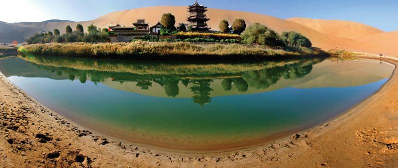
被誉为“沙漠第一泉”的月牙泉,千百年来不为流沙所淹没,不因干旱而枯竭。茫茫大漠中有此一泉,是大自然造化的神奇,令人心醉神迷。导游介绍,月光下的月牙泉更加美丽,最好在农历十五月圆之夜时来,露宿鸣沙山可以见到梦幻般的仙境。
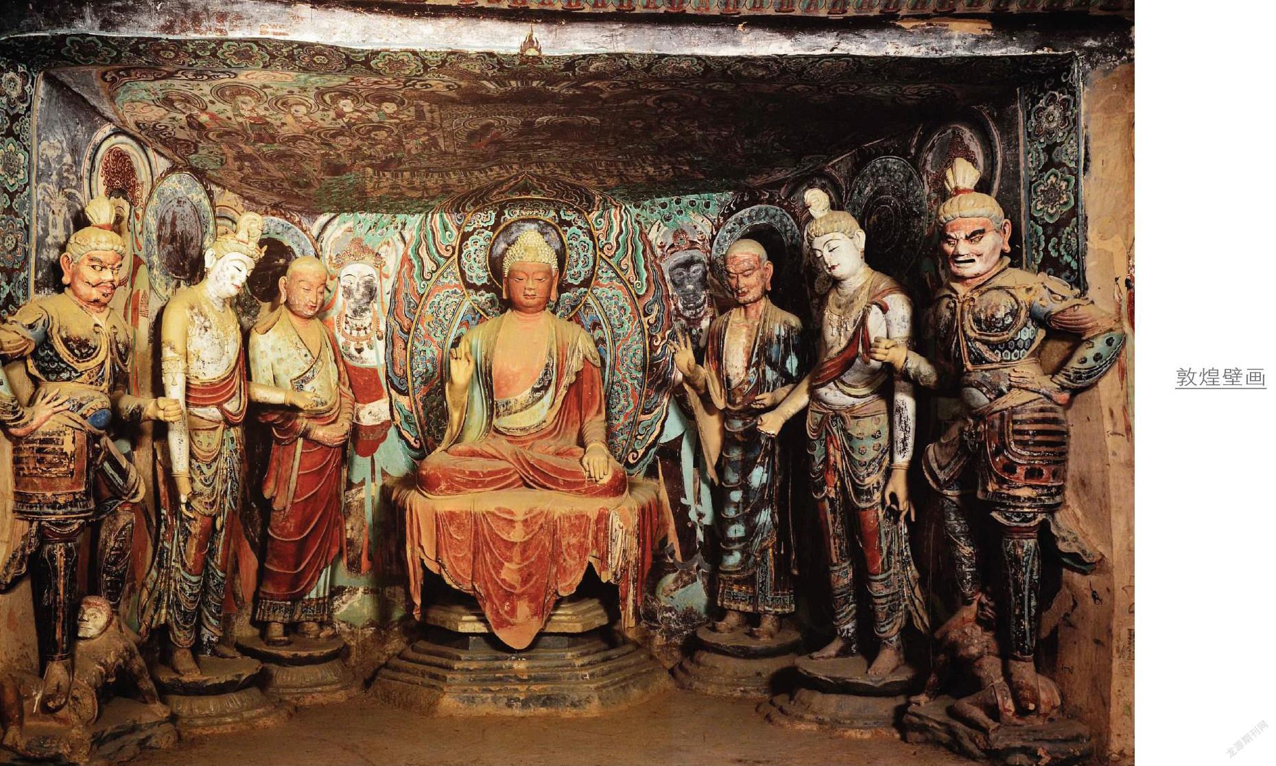
到敦煌不能不去莫高窟。莫高窟,也称千佛洞,坐落在敦煌城东南25公里处、鸣沙山东麓的崖壁上。进入莫高窟,犹如到了神圣殿堂。1600多年的开凿与修复,彩塑、壁画、飞天,集佛家思想和天马行空的艺术于一身,静下心来欣赏,仿佛能听到风中飘荡的斧凿声。
洞窟门一打开,历史的韵味扑面而来。这些栩栩如生的佛像用千年不变的平静面对游人,微微扬起的嘴角仿佛述说着乐观与豁达。
我们参观的洞窟中,最让人震撼的是莫高窟第一大佛,它凿建于唐朝,造型宏大、体态丰满、面容雕刻细致精巧,大佛的脚下有两个洞口,人们可以钻过佛像的两只脚,传言古人用钻佛脚的方式祈求平安。大佛完全是在石壁上凿出来的,使人不得不佩服古人的耐力和智慧。
敦煌文化源远流长。公元前111年,汉朝正式设立敦煌郡,为防御匈奴侵扰,汉朝廷从令居(今永登)经敦煌直至盐泽(今罗布泊)修筑了长城和烽燧,并设置了阳关、玉门关,敦煌成为中原通往西域的“咽喉”“锁钥”和边防军事重镇。
汉代丝绸之路自长安出发,经过河西走廊到达敦煌,继出玉门关和阳关,沿昆仑山北麓和天山南麓,分为南北两条道路。南线从敦煌出发,经楼兰,过葱岭到安息,西至大秦(古罗马);北线由敦煌经高昌、龟兹,越葱岭至大宛。敦煌成为丝绸之路上的重要商贸城市。
汉唐之际,又沿天山北麓另开一条新路,由敦煌经哈密、巴里坤湖,越伊犁河至拂林国(东罗马帝国)。沿着丝绸之路,中国的丝绸及先进技术不断向西传播到中亚、西亚甚至欧洲,来自西域的物产亦传播至中原地区。丝绸之路上,各国使臣、将士、商贾、僧侣络绎不绝。西域胡商与中原汉族商客在此云集,从事中原丝绸、瓷器,西域珍宝,北方驼马以及当地粮食交易。这些繁荣景象,莫高窟的壁画上都有描述。
敦煌莫高窟,始建于前秦建元二年(公元366年)。僧人乐尊路经敦煌附近的鸣沙山,忽见金光闪耀,如现万佛,于是便在岩壁上开凿了第一个洞窟。此后历经隋、唐、五代、元等朝代修凿造像,数量之多蔚为壮观。隋唐时期,随着丝绸之路的繁荣,莫高窟开窟数量多达1000余窟,保存至今的有232窟,壁画和塑像都达到非常高的艺术水准。
1900年6月,敦煌莫高窟下寺道士王圆箓在清理积沙时,发现藏经洞,并挖出公元4世纪至-11世纪的佛教经卷、社会文书、刺绣、绢画、法器等文物50000余件。从此敦煌不再平静,它在被掠夺中走向世界。面对敦煌遭遇的重重劫难,中国知识分子义无反顾地站了出来,段文杰、樊锦诗、王旭东……在保护敦煌的路上跋涉前行。
如今,莫高窟保护已从常规保护转为科学保护,数字技术被引入遗产保护,将洞窟、壁画、彩塑及与敦煌相关的一切文物加工成智能数字图像。同时将分散在世界各地的敦煌文献、研究成果等相关资料,通过数字化处理汇集成电子档案,向世界展现敦煌的永恒价值。
In October, we took a bus in Lanzhou and went westwards along the Hexi Corridor through Wuwei, Zhangye, and Jiayuguan, to Dunhuang, about 1,100 kilometers away.
Dunhuang, situated in northwestern Gansu Province, covers an area of 31,200 square kilometers. The towering Sanwei Mountain rises in the east, the magnificent Qilian Mountain stands in the south, the vast Taklamakan Desert lies in the west, and the jagged Beisai Mountain settles in the north. It was a stronghold connecting Hexi Corridor, Qiangzhong Route (Qinghai Route), Southern Route, and Northern Route of Xiyu (Western Regions), witnessed the exchanges between Han and Tang dynasties and Xiyu (Western Regions), and brought Chang’an, capital of Tang dynasty, and the Persian Gulf closer. It is renowned for grottoes and murals, which withstood the vicissitudes.
Night fell when we arrived in Dunhuang. The famous Shazhou Night Market was our first destination, even before we recovered from the tiring journey. As the largest night market in the city, it enjoys distinctive local features and rich folk customs and is reputed as the “night view photo” of Dunhuang. October was the peak season for tourism, and Shazhou Night Market was swarming with visitors.
Tasting local snacks, drinking iced beer, looking into the starry sky — how amazing! The night sky of Dunhuang was particularly clear, with the bright moon showering its silvery light on the ground. I have been living in cities for so long that I cannot remember if I’ve ever seen so many stars. Dunhuang was not large, without soaring skyscrapers and flyovers, but neatly-arranged buildings and clean streets. I felt like I had traveled back to ancient times, as being surrounded by constructions of Han and Tang dynasties, the statues of Flying Apsaras on streets, and vivid murals.
Early the next morning, we came to Mingsha Mountain (Singing Sand Dune). In the sunlight, the sands were like waves, rushing and undulating in a spectacular way. Climbing up the mountain, I heard sands and spring water echoed with each other, just like the orchestra played beside my ears. History of the Later Han-Administrative Geography, citing Xiangyang Qijiu Ji, said, “In Dunhuang, ‘it is strange that sands on the mountain can sing; it is amazing that there are waterfalls.’” According to the description of Mingsha Mountain in the Old book of Tang-Geography, “in sunny days, the sound of sand can be heard within the city.” It’s said that once upon a time, a general lost a battle here. The army, with tens of thousands of soldiers, was annihilated. Suddenly, fierce winds came, and flying sands and rocks blotted out the sky and covered the sun. Dunes sprout up overnight, and people heard the sound of drums and horns came from inside of such dunes. Hence the name Mingsha Mountain (Singing Sand Dune). Local people call it “Five-color Sacred Sand Mountain”, as the sands are in red, yellow, green, black, and white.
Crescent Spring, known admiringly as “First Spring in the Desert”, neither has been swallowed by quicksand nor dried up by drought for thousands of years. It’s a natural miracle to have such a spring in the desert. The guide told us Crescent Spring was even more appealing in the moonlight. Camping on Mingsha Mountain on full-moon nights, you might see dreamlike scenes.
Mogao Grottoes is a must-visit destination in Dunhuang. Also known as the Thousand Buddha Grottoes, it is located on the eastern foothills of the Mingsha Mountain, 25 kilometers southeast of Dunhuang. I felt like entering a hall of Buddhism when visiting the Mogao Grottoes. Over 1,600 years of discovery and repairing present colorful statues, murals, and flying apsaras, which embody Buddhist thoughts and art, to the world. Immersed in them, you seem to hear a chisel in the wind.
