The influence of climate and topography on chemical weathering of granitic regoliths in the monsoon region of China
2018-10-26···
···
Abstract Exploring the relationship between weathering and erosion is essential for understanding the evolution of landscapes and formation of soil under the influence of climate,tectonics,and topography.We measured the bulk chemistry of regoliths and calculated their weathering rates and intensity in three locations in China:Inner Mongolia in the mid-temperate semi-humid zone;Jiangxi Province,in the mid-subtropical humid zone;and Hainan Province,in the tropical humid zone.These profiles exhibited increased weathering with increasing temperature and precipitation.The low-gradient profile exhibited stronger weathering of saprolite than of soil,whereas the high-gradient profile showed a more constant weathering pattern.The regolith in the cold climate was the product of easily weatherable minerals,whereas weathering of K-feldspar and even secondary minerals occurred in hot and humid climates.The weathering of subtropical profiles was both supply-and kinetic-limited,controlled by weathering and erosion.The tropical profile experienced supply-limited weathering,indicating slow erosion and an intense weathering profile;the mid-temperate profile was not classifiable due to weak erosion and weathering.Long-term weathering fluxes of these profiles show that Si,Na,and K(or Mg)represent the bulk of the mass lost through weathering.This study underscores that weathering of granitic regolith is controlled by both climatic conditions and landscape.
Keywords Granitic regolith⋅Chemical weathering⋅Supply-limited weathering⋅Kinetic-limited weathering
1 Introduction
The critical zone is the near-surface layer of Earth where interactions between rock,water,biota,and air sustain life(National Research Council 2001;Brantley et al.2007;Riebe et al.2017).Regolith chemistry can provide longterm records of changes in the critical zone(Brantley and Lebedeva 2011).The formation and development of regolith are generally driven by chemical weathering and physical erosion,which also influence each other(Riebe et al.2004a,b).Understanding the relationship between chemical weathering and physical erosion is important due to the processes’roles in driving evolution of landscapes under the influence of climate,tectonics,and lithology(Dixon and von Blanckenburg 2012;Ferrier et al.2016;Schoonejans et al.2016;Buss et al.2017;Ferrier and West 2017).A comparison of granitic regolith geochemistry across different climatic zones can help illuminate the effects of climate and tectonics on chemical weathering coupled with physical erosion.
Cosmogenic radionuclides and geochemical mass balance of weathered soil and parent rock can help determine weathering and erosion rates (Riebe et al.2001,2003,2004a).Many studies have applied this method to study weathering-erosion relationships and weathering rate limitations(climate,tectonics,and lithology)(Riebe et al.2003,2004a;Buss et al.2008;Dixon et al.2009a,2012,2016;Norton and von Blanckenburg 2010;Hewawasam et al.2013;Ferrier et al.2016).The physical erosion of bedrock enhances chemical weathering by increasing the supply of primary minerals and increasing specific area of rock fragments(White et al.1996;Hodson and Langan 1999;Riggins et al.2011;Dixon et al.2012).However,sufficiently high erosion rates also limit chemical weathering since rapid erosion leads to decreased soil residence time,resulting in insufficient time for complete weathering of minerals(Riebe et al.2004b;West et al.2005;Ferrier and Kirchner 2008;Gabet and Mudd 2009).The positive correlation between weathering and erosion rates would suggest tectonic uplift enhances chemical weathering(e.g.Stallard and Edmond 1983;Riebe et al.2004a;Hilley et al.2010;Larsen et al.2014).Conversely,a weak or negative correlation between weathering and erosion would suggest chemical weathering is mainly influenced by climatic factors(e.g.West et al.2005;Dixon et al.2009b,2016;Dere et al.2013).This study was designed to investigate the weathering of minerals, fluxes of solutes from granite weathering,and the weathering erosion relationship of regoliths.Coupling mineral and elemental variation with links between weathering and erosion advances our understanding of how climate and tectonics regulate regolith geochemistry.
2 Materials and methods
2.1 Study area
Profile NMG-3-1 is developed on monzonitic granites covered by fine black soil in Inner Mongolia,northeastern China(124°14′93′′E,49°53′03′′N).The slope is about 10°and the elevation of the profile is 400 m.The upper 20 cm of the profile is homogeneous black soil;the 20 to 60 cm layer of the profile turns to fine brown soil.It is in the midtemperate semi-humid monsoon zone.The mean annual temperature(MAT)is-0.4°C and annual temperatures vary between-7 and 7.3°C.Mean annual precipitation(MAP)is 558 mm and annual precipitation ranges from 353 to 866 mm(data from China Meteorological Data Service Center,http://data.cma.cn/site/index.html).NMG-3-1 is exposed by a road-cut at the bottom of a hill covered by well-developed plants(mainly Quercus mongolica).
The four profiles JLN-S1 to-S4 are from a hill in Longnan,Jiangxi Province,South China(114°46′45′′E,24°58′22′′N),with a slope of about 25°and approximate elevation of 200 m.The profiles are underlain by the Yanshanian granite complex(Fan and Chen 2000).This area is in the subtropical humid zone within the influence of the East Asian monsoon.MAT is about 19°C,with a high monthly mean maximum temperature of 27.7°C in July.MAP is about 1600 mm;over 50%of precipitation occurs during April and July(Zhang et al.2015).The hillslope is covered by well-developed plants within the subtropical evergreen broad-leaved forest.The deepest profile(JLN-S1)is at the bottom of the hill,exposed by a road cut;the other profiles(JLN-S2,-S3,and-S4)are along the ridgeline hillslope.For more geologic and pedological information see Zhang et al.(2015)and Liu et al.(2016).
The profile HN-2 is developed on monzonitic granites covered by laterite in Ledong County,Hainan Province,South China(109°07′15′′E,18°37′52′′N).The profile is in a gentle hillslope(slope of 3°)with an approximate elevation of 200 m.This region is in the tropical humid zone,controlled by the East Asian monsoon.MAT is 24°C,with annual temperatures varying from 20.5 to 28.6°C.Annual precipitation varies from 1200 to 2400 mm,and averages around 1800 mm(China Meteorological Data Service Center),with most precipitation occurring in the warm season.The bottom of the profile(a depth of about 7 m)is above fresh bedrock.This profile is covered by evergreen broad-leaved shrubs and artificial rubber forest,500 m northeast of Leguang Farm.
All the hillslopes are underlain by granites with similar major minerals.Major minerals of the bedrock at JLN are quartz,K-feldspar,plagioclase,and biotite;and minor minerals hornblende and chlorite(Zhang et al.2015;Liu et al.2016).Similarly,bedrock at NMG-3-1 and HN-2 is mainly composed of K-feldspar,plagioclase,quartz,and small amounts of biotite and hornblende.The similar mineralogy of bedrock in the different profiles facilitates comparison of weathering conditions and regimes.Based on field observations,all regoliths are in situ granite weathering profiles,but are potentially influenced by atmospheric dust and rainfall.The exposure times of NMG-3-1,JLN-S1,and HN-2 are 0.3,0.3,and 0.5 Ma,respectively(Cui 2015).Thus,the influence of residence time and sources of soil and saprolite are not considered as major factors in this paper.
2.2 Analytical methods
Soil samples were air-dried and passed through a 2-mm sieve.Bulk soils(<2 mm),saprolite,and fresh bedrock were then ground to pass through a 75-μm sieve prior to major element analysis.The concentrations of major elements for bulk samples were measured using X-ray fluorescence spectrometry(Axios XRF).The elements were expressed as SiO2,Al2O3,TFe2O3(including Fe(II)and Fe(III)),Na2O,K2O,MgO,CaO,P2O5,MnO,and TiO2,for which relative uncertainties were±0.20%,±0.10%,± 0.05%,± 0.03%,± 0.02%,± 0.03%,± 0.03%,±0.005%,±0.005%, and±0.005%, respectively.Detection limits were around 100 μg/g.Chinese national standard samples were used to monitor data quality.Loss on ignition(LOI)data were calculated from the mass difference between a 1-g soil sample before and after combusted at 950°C for 1 h.Most of the major element concentrations of regolith samples were measured within the optimal analysis range for the Axios XRF.Some upper profile samples,which had slightly lower values of Na,Ca,Mg,and Mn,were measured by inductively coupled plasma–optical emission spectrometry(ICP-OES)by aciddigestion,with detection limits of several μg/g and analytical uncertainty better than 5%.
2.3 Calculation of chemical weathering,denudation,and weathering index
Changes in elemental concentrations that occur during weathering can be expressed by mass-transfer coefficient for element X(τX)(Brimhall and Dietrich 1987;Anderson et al.2002).These tau values(τX)indicate elemental loss(τX<0)or gain(τX>0)relative to the composition of the parent rock and are calculated as:

where[X]and[I]are the concentrations of the given element X and an immobile element(usually Ti and Zr),respectively;and the subscripts ‘‘weathered’’and ‘‘parent’’refer to elements in weathered material and parent rock,respectively.Ti was used as the immobile element for calculation of tau values and chemical depletion fraction(CDF)in this study,based on earlier studies about mobility during weathering(Zhang et al.2015;Liu et al.2016).
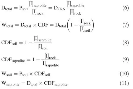
The total fractional mass loss in regolith caused by chemical weathering can be expressed as(Riebe et al.2003):

where[I]rockand[I]soilare the concentrations of the immobile element in bedrock and soil,respectively.Chemical weathering intensity is commonly evaluated by CDF(Riebe et al.2003;Dixon et al.2009a).
Considering the thick soil profiles,denudation rate can be expressed as(Dixon et al.2009a,b;Riebe and Granger 2013):

where Dtotalis total denudation rate,E is physical erosion rate,and Wtotalis the total weathering rate that can be separated into soil(Wsoil)and saprolite(Wsaprolite).The soil production rate can be expressed as:

The denudation rate determined by cosmogenic radionuclide(CRN)is equal to soil production rate(Psoil),assuming soil is at steady state(Heimsath et al.1997;Dixon et al.2009a):

Dtotaland Wtotal,CDF caused by soil weathering(CDFsoil)and by saprolite weathering(CDFsaprolite),and Wsoiland Wsaproliteare calculated as follows(Dixon et al.2009a;Hewawasam et al.2013)
To investigate element behavior during chemical weathering,the weathering extent of profiles was evaluated by a weathering index.Chemical index of alteration(CIA)was selected to quantify the degree of weathering,de fined as:

with all content in molar ratios,where CaO*refers to content of CaO in the silicate fraction(Nesbitt and Young 1982)and is corrected by the method of McLennan(1993).
3 Results
The concentrations of major elements from the samples are listed in Table S.1.Profiles NMG-3-1,JLN-S1,and HN-2 returned average CIA values of 63,80,and 84,respectively.With depth,CIA values of the thick profiles showed slight decrease in NMG-3-1(Figs.1,2a),significant decrease in JLN-S1(Fig.3a),and nearly constant values in HN-2(Fig.4a).Profiles NMG-3-1 and JLN-S1 exhibit transitions in CIA values at 80 and 350 cm,respectively(Zhang et al.2015;Liu et al.2016).Based on field observations and on the transitions in CIA values,the soilsaprolite boundaries are assumed to be at depths of 350 and 80 cm for profiles JLN-S1 and NGM-3-1,respectively.
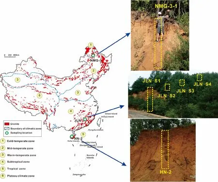
Fig.1 Sites location map,photographs of the profile NMG-3-1,JLN-S1,and HN-2
CDF calculated from mean Ti concentrations of soil and bedrock varied between 0.20 and 0.69(Table 1)for all profiles.Because of soil and saprolite heterogeneity,the mean concentrations of Ti may lead to deviation in CDF.The influence of quartz veins in JLN-S1 should be excluded,thus the mean concentration of Ti topsoil(above 100 cm)was used to calculate the CDF of 0.38 for profile JLN-S1.Regarding the three thick regoliths,CDFs increased in the order NMG-3-1<JLN-S1<HN-2.In HN-2 and NMG-3-1,CDFssoilwas much lower than CDFsaprolite;however,CDFsoilwas higher than CDFsaprolitein JLN-S1.Dtotalranged from 37 to 279 t/km2/yr and Wtotalfrom 12 to 192 t/km2/yr across all profiles.Wsoilvaried between 4 and 7 t/km2/yr and Wsaprolitebetween 7 and 184 t/km2/yr(Table 1).
Na and Ca were considerably depleted to similar extents across the majority of the regolith in JLN-S1 and HN-2(Figs.3,4);however,Na and Ca were increasingly depleted toward the surface in the soil layer of NMG-3-1(Fig.2).The depletion of K and Mg were similar to Na and Ca in HN-2(Fig.4).K was enriched in the section below 30 cm in NMG-3-1 and gradually decreased from bottom to top in JLN-S1.Mg exhibited a similar pattern to Na and Ca in NMG-3-1(Fig.2)and steady but less depletion(τMgaround 0.6)in JLN-S1.Depletion of Si was observed in the thick profiles and increased with the sequence:NMG-3-1≤JLN-S1<HN-2.In NMG-3-1,Al and Fe were increasingly enriched with depth in the soils and less changed in saprolites.Aluminum was more severely depleted in HN-2 than in JLN-S1,but less variable in saprolites of both profiles.Fe was slightly enriched in the soil,but slightly depleted in saprolite of JLN-S1.In HN-2,except for the topsoil,τFevalues decreased from 150 to 45 cm and remained nearly constant below 150 cm.In addition to Fe,other elements showed slightly decreasing trends of tau values from 150 to 45 cm.
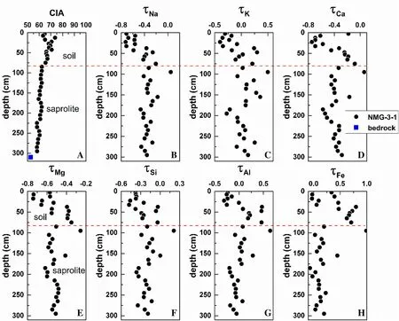
Fig.2 CIA and tau values of major elements of the profile NMG-3-1.The red dash line is the boundary between soil and saprolite
4 Discussion
4.1 Chemical weathering intensity and elemental behavior of the regolith
Chemical weathering indices are used to characterize weathering profiles and allow comparison between profiles in different locations(Price and Velbel 2003).CIA values of the thick profiles in this study indicate weak chemical weathering in NMG-3-1 and intense chemical weathering in JLN-S1 and HN-2.However,mean CDFs suggest greater weathering intensity in profile HN-2 than in profile JLN-S1.Saprolite weathering rates exceeded soil weathering rates in HN-2 and NMG-3-1,consistent with more a slowly eroding regolith(Dixon et al.2009a,b,2012),which is likely due to more weather able minerals remaining in saprolite than soil,and to a low erosion rate(Table 1).However,similar Wsaproliteto Wsoiland lower CDFsaprolitethan CDFsoilwere observed in JLN-S1(Table 1),suggesting that soil weathering is likely enhanced by increasing soil production rates and mineral supply rates since the slope at JLN-S1 is higher than at HN-2 and NMG-3-1(< 10°)(Dixon et al.2012).A high-gradient hillslope increases soil production rate and erosion rate,which results in increased weathering rates until the slope exceeds the threshold of 30°(DiBiase et al.2010;Dixon et al.2012;Heimsath et al.2012).The difference between soil and saprolite weathering suggests that the gradient also influences erosion and weathering at a hillslope scale.NMG-3-1 and JLN-S1 returned intermediate Wtotalrates,whereas Wtotalof HN-2(192 t/km2/yr)is higher than the weathering rate speed limit of 150 t/km2/yr(Dixon and von Blanckenburg 2012),suggesting this profile has experienced highly intense weathering.
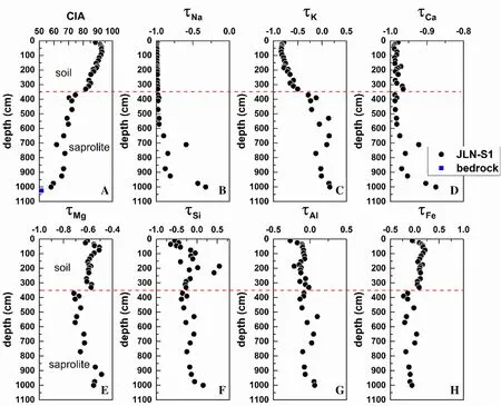
Fig.3 CIA and tau values of major elements of the profile JLN-S1.The red dash line is the boundary between soil and saprolite
Depletion of Na(τNa)can be a proxy for weathering plagioclase(Brantley and White 2009;Rasmussen et al.2011).The significant correlation between τNa, τCa,and plagioclase content in JLN-S1 suggests that depletions of Na and Ca derived from plagioclase weathering(Fig.S.1)(Liu et al.2016).However,in NMG-3-1,the poor correlation between Na and Ca and high positive correlation between Ca and Mg suggest that the depletion of Ca can be partially attributed to other minerals’weathering,such as hornblende or(secondary)carbonate.HN-2 exhibited a similar pattern among Ca,Na,and Mg,suggesting significant weathering of primary minerals.Biotite can release K during early weathering(Buss et al.2008)and subsequently release Mg during formation of kaolinite(Murphy et al.1998).Furthermore,kaolinite would adsorb Mg(Huang et al.2012).Thus,the increasing depletion of Mg from 1000 to 350 cm is attributed to biotite weathering,and less depletion of Mg in soil suggests adsorption of Mg on kaolinites in JLN-S1(Fig.3e).The loss of K is dominated by oxidation of biotite at deeper depths and K-feldspar weathering at shallower depths,which is consistent with K-feldspar contents(Buss et al.2008;Liu et al.2016).The weak correlation between Mg and K and stronger depletion of Mg than K suggest hornblende has also weathered in NMG-3-1.The significant depletion of K and Mg across the entirety of HN-2 suggests biotite,hornblende,and K-feldspar have been significantly weathered.Si is sharply depleted in the soil and slightly depleted in saprolite of NMG-3-1 and JLN-S1.Due to the lower mobility of trivalent Fe and Al,these elements often display redistributions within a profile rather than simple loss and gain patterns(Chadwick et al.1990;Dixon et al.2016).Aluminum was generally conserved in saprolite of NMG-3-1 and the entire profile JLN-S1.However,Al was enriched in deeper soil and depleted in topsoil(above 25 cm)for NMG-3-1,associated with the low pH(about 4.8)in topsoil(Fig.S.2),which is likely due to low pH or dissolved organic matter that enhance dissolution of Al oxides and clay minerals and re-precipitation of Al in deeper soil layers(Brantley and Lebedeva 2011;White and Buss 2014;Eriksson et al.2016).In HN-2,approximately 40%of Al was depleted below 30 cm,suggesting Al(hydr)oxides have been intensely weathered.Fe was mainly depleted in topsoil and enriched in the lower soil for the thick profiles(Figs.2h,3h,4h),suggesting downward mobilization of Fe(II),which likely results from reduction via soil organic carbon(Hall et al.2016),and subsequent reprecipitation as Fe(III)(hydr)oxides(White and Buss 2014;Zhang et al.2015).In summary,profile NMG-3-1 showed slight dissolution of biotite,hornblende,and plagioclase;profile JLN-S1 indicates weathering of K-feldspar and formation of secondary minerals;and profile HN-2 exhibited significant weathering of primary minerals and even some secondary minerals.
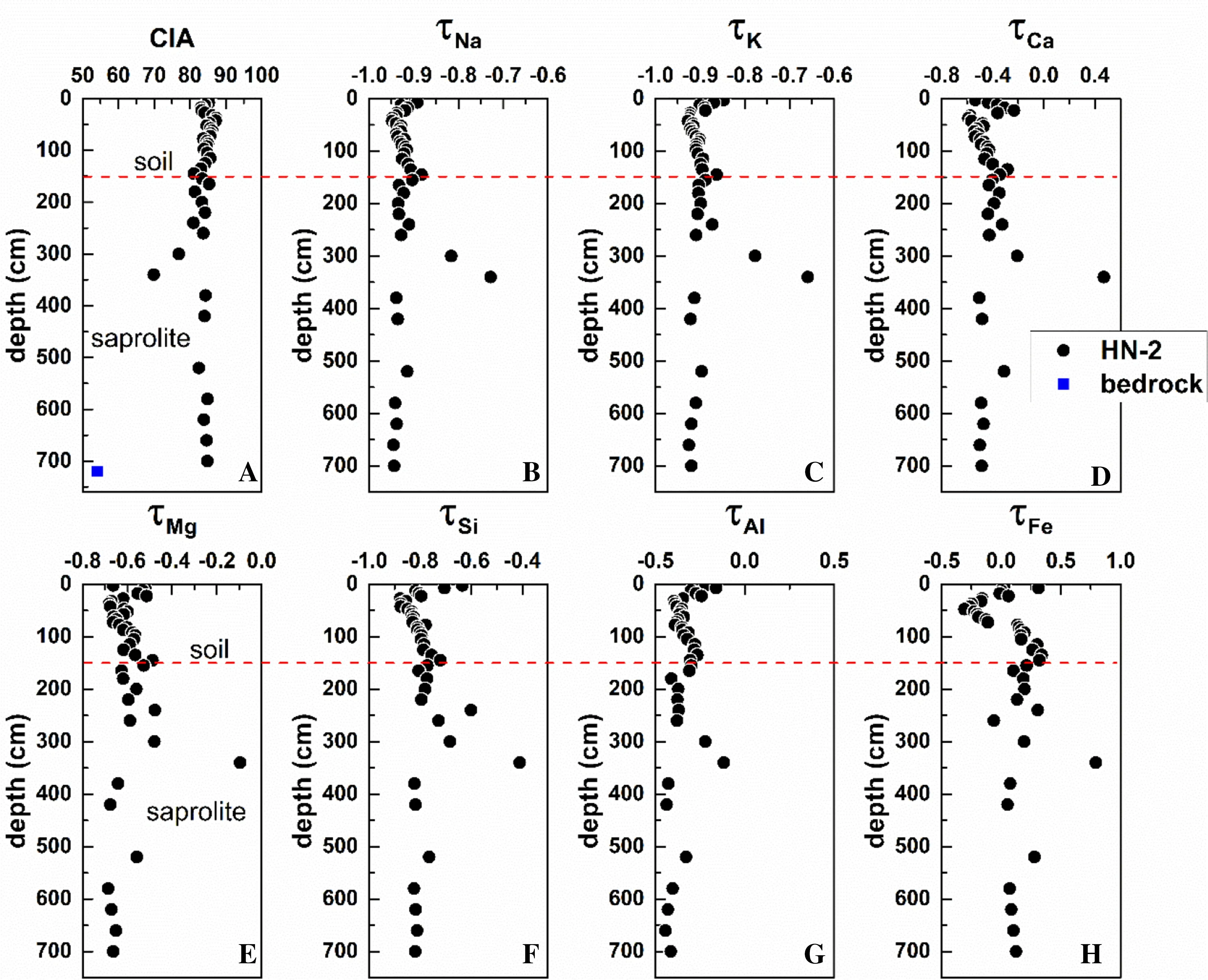
Fig.4 CIA and tau values of major elements of the profile HN-2.The red dash line is the boundary between soil and saprolite

Table 1 Denudation rates,weathering rates and CDFs of total,soil,and saprolite
4.2 Supply-limited and kinetic-limited weathering
A framework of rate limitations has commonly been used to interpret chemical weathering rates in regolith(Riebe et al.2017),consisting of two end-members:supply-limited and kinetic-limited chemical weathering(Riebe et al.2004a,2017;West et al.2005;Ferrier and Kirchner 2008;Dixon et al.2009a;Gabet and Mudd 2009;Hilley et al.2010;Lebedeva et al.2010;Ferrier et al.2016;Riebe et al.2017).According to the definition of the two end-members(West et al.2005;Riebe et al.2017),the relationship between CDF and mineral supply rate can be expressed as:

where S is mineral supply rate,a is an intercept,and b is the power law slope of the relationship between CDF and S.
In supply-limited weathering,b=0 because weathering rates are proportional to mineral supply rates(at steady state,S=DCRN)and CDF is invariant with mineral supply rates.In kinetic-limited weathering,b=-1 because weathering rates are invariant with mineral supply rates and CDF is inversely proportional to mineral supply rates(Ferrier et al.2016).Thus,this method can be used to assess whether chemical weathering is supply-or kineticlimited for a series of profiles on a hillslope.The b value of-0.41±0.13 for profiles JLN-S1 to-S4(Fig.5)suggests chemical weathering is influenced by both mineral supply rates and dissolution kinetics.The profiles exhibited some characteristics of supply-limited weathering,including complete weathering of active minerals(e.g.plagioclase)(Hilley et al.2010;Lebedeva et al.2010;Rasmussen et al.2011;Ferrier et al.2016)and relatively low denudation rates(<100 t/km2/year)(Gabet and Mudd 2009).However,the profiles also bore characteristics of kinetic-limited weathering,including relatively high gradient slope(25°)(Dixon et al.2012)and decreased CDF with increasing denudation(Norton and von Blanckenburg 2010;Larsen et al.2014;Ferrier et al.2016;Schoonejans et al.2016).Therefore,the regoliths in JLN are consistent with evaluation based on the slope of the power law relationship between CDF and S.Nevertheless,the approach of power law slope cannot be applied for a single profile.As shown in Fig.5,the regoliths were classified as supply-limited or kinetic-limited weathering.Profile HN-2 fell in the area of supply-limited weathering.Moreover,HN-2 presented a high degree of chemical weathering(CDF=0.7),with a very low gradient.This is consistent with the sufficient precipitation and high temperatures at the site.In contrast,profile NMG-3-1 is the outlier in Fig.5.This profile showed low CDF(0.2),low weathering rates(11.6 t/km2/yr),low gradient(10°),and low erosion rates(46.3 t/km2/year),reflecting weak weathering and erosion.The low weathering rate of NMG-3-1 might be limited either by low mineral supply rate due to low erosion rates and low gradient,or by low dissolution rates of minerals due to the cold climate and less precipitation.Thus,while the factors controlling the weathering of profile NMG-3-1 are uncertain,erosion is the main process.
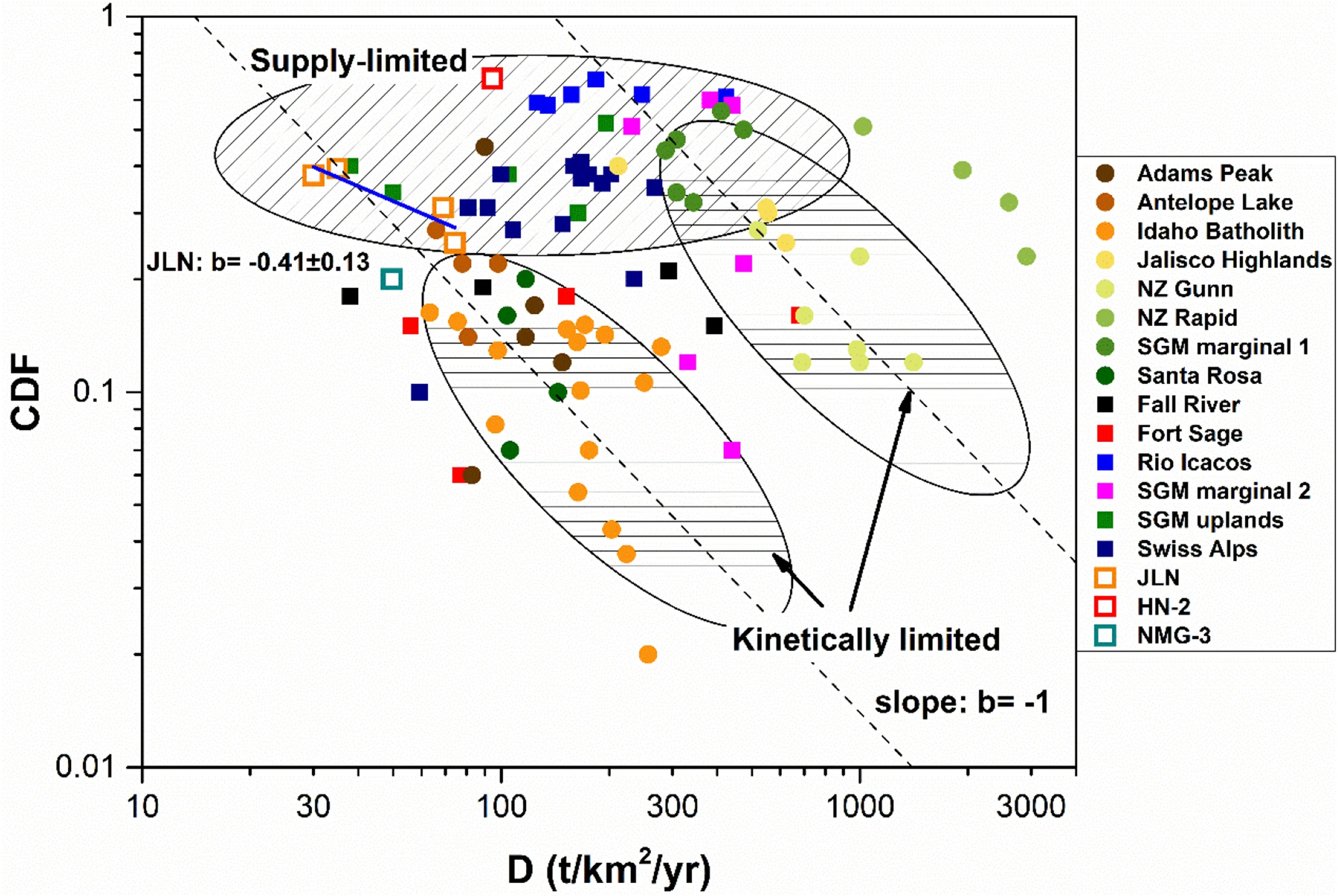
Fig.5 CDF versus D values of the profiles data.The solid circle represents the regolith is kinetic-limited weathering,and solid square represents the regolith is supply-limited weathering.The data of solid marks and the method of classification are derived from(Ferrier et al.2016).The open square represents regolith in this study.The profiles along the hill ridge in JLN exhibit the slope b=-0.41±0.13 using simple linear regression.The profile HN-2 is shown in the area marked on supply-limited.The profile NMG-3-1 is the outlier of two end-members

Table 2 The elemental flux of soil water released from granite weathering
In kinetic-limited weathering,weathering rates of regolith should depend on factors such as temperature, fluid chemistry,and fluid velocity,which are largely influenced by climate(Riebe et al.2001;Dixon et al.2009b;Norton and von Blanckenburg 2010;Schoonejans et al.2016).In supply-limited weathering,rates should be linearly coupled with mineral supply rates,which are mainly modulated by tectonic uplift(Riebe et al.2003,2004b;Dixon et al.2012;Hewawasam et al.2013;Larsen et al.2014).Therefore,the two weathering regimes represent the influence of climate and tectonics.Nonetheless,tectonic uplift may not only enhance chemical weathering rates by increasing mineral supply rates,but also reduce weathering rates due to higher erosion rates,decreasing soil residence time(West et al.2005;Dixon et al.2012).Temperature and precipitation may also influence regolith production rates by freeze–thaw and soil transport through overland flow(Hales and Roering 2007;Dixon et al.2009a,b).Therefore,most of the regolith is influenced by both tectonic and climatic forcing,suggesting the study of chemical weathering would benefit from a more comprehensive perspective.
4.3 Flux of pore water released from granite weathering
Assuming regolith is at steady state,the flux of the element X into soil water(FX)over long-term weathering is equal to the rate that X enters the soil from bedrock multiplied by the fraction of X lost during chemical weathering(-τX).The rate of X transferring from bedrock to soil can be calculated as total denudation rate(Dtotal;see Eq.(6))multiplied by the concentration of X in bedrock.Thus,the long-term weathering flux of X through soil water can be calculated as(Riebe et al.2003;Hewawasam et al.2013;Ackerer et al.2016):

where τXis calculated based on Eq.(1)and the mean concentration of weathered material refers to the soil.
The flux of X of soil water(Eq.14)entering the river is the average flux over the long-term,which in many cases is different from the instantaneous flux of solutes measured.However,measured instantaneous flux vacillates around the long-term mean flux(Hewawasam et al.2013).Changes in flux may indicate variation in contribution of granite weathering to rivers or even oceans over long periods.Profile fluxes are shown in Table 2.Calculated long-term weathering fluxes of profile HN-2 were much higher than those of NMG-3-1 and JLN-S1.The Si flux in JLN-S1 was lower than that of NMG-3-1,which we attribute to transfer of fine particle clay minerals rather than dissolved Si.The long-term weathering fluxes of the thick profiles suggest Si,Na,and K(or Mg)are the main sources of mass loss by weathering.
5 Conclusions
We studied the weathering processes of regoliths developed on granite in different climates.Thicker profiles exhibited greater degrees of weathering with higher temperature and precipitation.Low-gradient profiles exhibited stronger weathering of saprolite than of soil,whereas the high-gradient profile showed similar weathering patterns for the two.The cold climate regolith is the product of weathering of easily weatherable minerals;weathering of K-feldspar and even secondary minerals occurs in regolith in hot and humid climates.
The profiles in Jiangxi Province suggest chemical weathering is both supply-and kinetic-limited,influenced by both topography and climate forcing and by weathering and erosion.The profile in Hainan Province displayed characteristics of supply-limited weathering,indicating a slow eroding and intense weathering profile,and the profile in Inner Mongolia did not have enough data to judge the limitation of weathering.Si,Na,and K or Mg seem to be the main mass losses by weathering in the thick profiles.Chemical weathering of the regoliths is mainly controlled by climate,except that a high-gradient hillslope(> 25°)can increase erosion of soils and decrease the amount offine particles.
AcknowledgementsThis work was jointly supported by the National Natural Science Foundation of China(Grant Nos.41210004;41661144042;41603018)and National Basic Research Program(973 project)of China(2013CB956401).We sincerely thank two anonymous reviewers for their very constructive and thoughtful comments.
杂志排行
Acta Geochimica的其它文章
- Trace element composition of magnetite from the Xinqiao Fe-S(-Cu-Au)deposit,Tongling,Eastern China:constraints on fluid evolution and ore genesis
- Theoretical calculation of equilibrium Mg isotope fractionation between silicate melt and its vapor
- Zinc isotope fractionation under vaporization processes and in aqueous solutions
- The partitioning patterns of nutrients between pods and seeds of Zanthoxylum fruits impacted by environmental factors
- Geological significance of nickeliferous minerals in the Fule Pb-Zn deposit,Yunnan Province,China
- Iron isotopic analyses of geological reference materials on MCICP-MS with instrumental mass bias corrected by three independent methods
