Integrating BDS and GPS for precise relative orbit determination of LEO formation flying
2018-10-15BinYIDefengGUXiaoCHANGKaiSHAO
Bin YI,Defeng GU,Xiao CHANG,Kai SHAO
College of Liberal Arts and Sciences,National University of Defense Technology,Changsha 410073,China
KEYWORDS Ambiguity Dilution Of Precision;BeiDou Navigation Satellite System;Geostationary-Earth-Orbit;Global Positioning System;LEO formation flying;Precise Relative Orbit Determination
Abstract Low-Earth-Orbit(LEO)formation- flying satellites have been widely applied in many kinds of space geodesy.Precise Relative Orbit Determination(PROD)is an essential prerequisite for the LEO formation- flying satellites to complete their mission in space.The contribution of the BeiDou Navigation Satellite System(BDS)to the accuracy and reliability of PROD of LEO formation- flying satellites based on a Global Positioning System(GPS)is studied using a simulation method.Firstly,when BDS is added to GPS,the mean number of visible satellites increases from 9.71 to 21.58.Secondly,the results show that the 3-Dimensional(3D)accuracy of PROD,based on BDS-only,GPS-only and BDS+GPS,is 0.74 mm,0.66 mm and 0.52 mm,respectively.When BDS co-works with GPS,the accuracy increases by 29.73%.Geostationary-Earth-Orbit(GEO)satellites and Inclined Geosynchronous-Orbit(IGSO)satellites are only distributed over the Asia-Pacific region;however,they could provide a global improvement to PROD.The difference in PROD results between the Asia-Pacific region and the non-Asia-Pacific region is not apparent.Furthermore,the value of the Ambiguity Dilution Of Precision(ADOP),based on BDS+GPS,decreases by 7.50%and 8.26%,respectively,compared with BDS-only and GPS-only.Finally,if the relative position between satellites is only a few kilometres,the effect of ephemeris errors on PROD could be ignored.However,for a several-hundred-kilometre separation of the LEO satellites,the Single-Difference(SD)ephemeris errors of GEO satellites would be on the order of centimetres.The experimental results show that when IGSO satellites and Medium-Earth-Orbit(MEO)satellites co-work with GEO satellites,the accuracy decreases by 17.02%.
1.Introduction
With the development of small satellites,formation- flying satellites become a key technology for advanced space missions.Compared with large single satellite,formation- flying satellites offer more flexibility and redundancy,shorter time for mission completion,and the prospect of being more cost effective.They also provide advance science opportunities that cannot,or cannot easily,be realised with a single satellite.1At present,the Low-Earth-Orbit(LEO)formation- flying satellites are widely used in mapping,synthetic-aperture-radar imaging and meteorological reconnaissance.Examples include the Gravity Recovery And Climate Experiment(GRACE),2the TerraSAR-X add-on for Digital Elevation Measurement(TanDEM-X),3the Constellation Observing System for Meteorology,Ionosphere,and Climate(COSMIC),4the Prototype Research Instruments and Space Mission Technology Advancement(PRISMA)5and the Shi Jian-9 formation flight mission(SJ-9).6
Precise Relative Orbit Determination(PROD)is a necessary prerequisite for the LEO formation- flying satellites to complete their mission in space.For many years,the Global Navigation Satellite System(GNSS),with its advantages of all-time,all-weather,high-accuracy positioning and nearcontinuous availability,has been indispensable for PROD.7Installing dual-frequency GNSS receivers on satellites,through Double-Difference(DD)GNSS carrier-phase observations with fixed integer ambiguities,can achieve millimetre-level relative positioning accuracy.1For instance,PROD obtained a Root Mean Square(RMS)error of 0.88 mm for K-Band Ranging(KBR)validation using GRACE.8Internal comparison indicated that the relative orbit accuracy of TanDEM-X achieved a 1 mm level for each axis,9and PROD’s GPS-based accuracy using PRISMA reached a level of 1 dm.10A sequence of internal consistency checks confirmed the subcentimetre-level precision of the kinematic relative position using SJ-9.6For the baseline,a consistency of better than 0.7 mm with KBR observations is achieved using the GRACE satellite formation.11However,because of the high-speed movement of LEO satellites,unlike the receivers on the earth’s surface,the continuous tracking arcs are always restricted to less than one hour.Allende-Alba and Montenbruck pointed out that the unreliability of the PROD methods based on GPS was almost a result of the short continuous carrierphase tracking arcs,which increased the difficulty of fixing integer ambiguities.12In this study,the focus is on the contribution of the BeiDou Navigation Satellite System(BDS)to PROD’s accuracy and reliability for LEO formation- flying satellites.
BDS was independently constructed and operated by China and will provide navigation services for world-wide users by 2020.It is a mixed navigation constellation,consisting of five Geostationary-Earth-Orbit(GEO)satellites,three Inclined Geosynchronous-Orbit(IGSO)satellites and 27 Medium-Earth-Orbit(MEO)satellites.13Considering the country’s national security and technical independence,BDS will be China’s first choice for its own LEO satellites.In addition,BDS’s appearance provides a chance to enhance the accuracy and reliability of PROD based only on GPS.Multi-constellation and multi-frequency data-fusion GNSS have many advantages,for example,they can reduce hidden risks,e.g.inadequate satellite numbers and major service failures.The multiconstellation aspect will improve the geometric strength,and the integer ambiguity can be fixed more reliably.14Meanwhile,there are some problems,e.g.the ephemerides for BDS are far worse than those for GPS,and the observations of GEO satellites have obvious cyclical multipath errors.15
Since the first BDS navigation satellite was launched on 14 April 200716,researches on BDS satellites have never stopped.Yang et al.analysed the contribution of the BDS to global Position,Navigation and Timing(PNT)users using simulation data.The simulation showed that when BDS co-worked with GPS,GPS+Galileo,andGPS+Galileo+GLONASS,the global Geometric Dilution Of Precision(GDOP)was improved by 50%,29.5%,and 29.5%,respectively.14Verhagen et al.used simulation experiments to show that,compared with GPS-only or BDS-only,GPS+BDS could effectively reduce the time required for fixing the integer ambiguity,which was more advantageous for realising the PROD of LEO formation flying in real time.17
Liu et al.obtained simulated BDS observations using the broadcast ephemerides,clocks,and fitted orbits.The results showed that the 3-Dimensional(3D)accuracy over the eastern hemisphere was much better than that over the western hemisphere.The relative positioning accuracy was 3.4 mm over the service area,and it was still better than 1 cm over the nonservice area,which demonstrated that the BeiDou regional constellation could provide global service to LEO satellites for PROD.18Liu et al.proposed integrated GPS and BDS to correct the ambiguity of the Precise Point Positioning(PPP)based on GPS,GPS+IGSO+MEO,and GPS+GEO+IGSO+MEO.For kinematic PPP,the fixed ambiguity percentages within 10 min were 17.6%,42.8%,and 23.2%,respectively.BDS+GPS made many improvements compared with GPS-only.19Applying BDS to LEO formation flying may be a promising solution for improving the accuracy and reliability of the relative orbit determination.
This study uses the simulation method to analyse PROD’s performance based on BDS-only,GPS-only,and BDS+GPS of LEO formation flying.Firstly,the BDS ephemerides are from the BDS theoretical constellation and the GPS ephemerides are from the IGS final GPS orbits.These are used to simulate the space-borne observations,and then the relative orbit is determined based on GPS-only,BDS-only,and BDS+GPS.Secondly,the influence of observation noise and ephemeris errors on PROD is analysed.Furthermore,because of the BDS characteristic,the accuracy over the Asia-Pacific region and the non-Asia-Pacific region is analysed,and the contribution of GEO satellites and IGSO satellites to PROD is discussed.Finally,the influence of a multi-constellation on the ambiguity resolution is studied.
2.Simulation scenarios and PROD models
BDS is planned to reach full operational capability by 2020.At present,there is no LEO formation- flying satellite that has a BDS receiver installed.Therefore,simulation was adopted to analyse the effect of BDS+GPS on the PROD of LEO formation- flying satellites.The simulation time was chosen from 9 to 23 June 2014.
The simulation experiment includes three steps.Firstly,the BDS satellite ephemerides are obtained from the BDS orbit parameters(see Table 1.17).Fig.1 shows the BDS design constellation.The GPS satellite ephemerides are from the IGS final GPS orbits.The clock offsets are set to 0,because the clock offsets could be completely eliminated by the Double-Difference(DD)observations,which are formed by subtracting two Single-Difference(SD)observations of the same type and frequency,taken by the same two GNSS receivers at the same instant,but each relating to a different GNSS satellite.The reference orbits of the LEO satellites are integrated usingthe orbit parameters shown in Table 2,where S1,S2,and S3 denote different LEO satellites,the average altitude of which is about 500 km.The average distance between S1 and S2 is about 2 km,and that between S1 and S3 is about 200 km.Furthermore,the ephemerides,clocks and orbits are used to simulate the space-borne observations,including dual-frequency pseudo-range and carrier phase.

Table 1 Orbit parameters of BDS.

Fig.1 BDS design constellation consisting of 5 GEO,3 IGSO,and 27 MEO satellites.
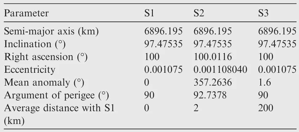
Table 2 Information of LEO satellite S1,S2 and S3.
Random Gaussian white noise is also added to the simulated observation with standard deviation values of σP=0.5 m,and σL=0.002 m.The pseudo-range and carrier-phase observations are denoted as P and L,respectively.The L1,L2,B1 and B3 frequencies are used.The sampling interval is set to 10 s,and the elevation cut-off angle is set to 5°.Finally,observations are used to determine the relative orbits of LEO satellites based on BDS-only,GPS-only,and BDS+GPS.PROD’s accuracy is defined as the RMS of the difference between the reference orbits and the determined relative orbits.PROD’s accuracy is based on the simulation scenarios.
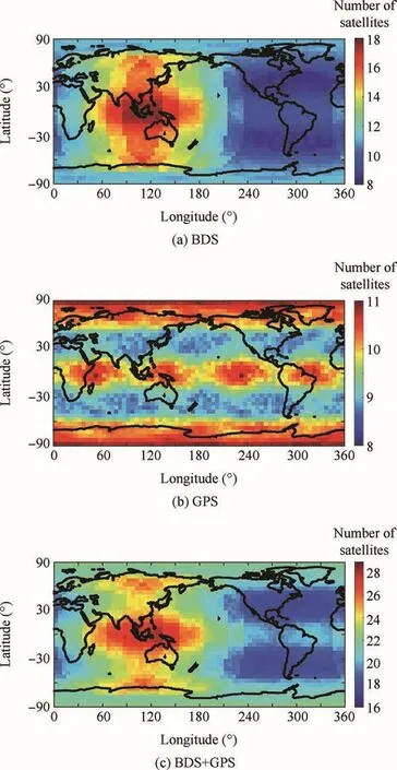
Fig.2 Average visible navigation satellites on altitude of 500 km over 5°.
The average visible navigation satellites at altitude of 500 km are placed on a global map over 15 days(see Fig.2).Fig.2(a)shows that the maximum number of visible BDS satellites reaches 18,the mean number of visible BDS satellites is more than 8 over America,and the number of visible BDS satellites has many improvements compared with that of BeiDou-2 system.18Because of the GEO satellites and IGSO satellites,the BDS coverage obviously differs from region to region,and the LEO satellites can observe more BDS satellites over the Asia-Pacific region.Therefore,the accuracy of PROD over the Asia-Pacific region and the non-Asia-Pacific region is analysed in this paper.
The Asia-Pacific region is defined as longitudes between 55°E and 180 °E and latitudes between 55 °S and 55 °N.Unlike BDS,the number of visible GPS satellites is from 8 to 11 globally,and the coverage is relatively uniformly distributed(see Fig.2(b)).Above all,the average numbers of visible navigation satellites based on BDS-only,GPS-only,and BDS+GPS are 11.87,9.71,and 21.58,respectively.Compared to BDS-only and GPS-only,the number of visible navigation satellites with integrated BDS and GPS improves by 81.80%and 122.25%,respectively.(see Fig.2(c)).
Fig.3 shows the percentage of time when the navigation satellites are visible from S1 and S2.The maximum number of observations from S1 and S2,based on BDS-only and GPS-only,are 19 and 15,respectively,whereas it is 30 for BDS+GPS.Moreover,combining BDS and GPS increases the average observations from S1 and S2 to 17.65(see Fig.3).It implies that integrating BDS and GPS increases the number of observations and enhances the geometric strength.Both are conducive to improving the accuracy of PROD.
Differenced GNSS data are used for PROD to eliminate or reduce the common data errors,e.g.navigation satellite clock errors and ephemeris errors.The DD-observation equations for one epoch t are given in Eqs.(1)and(2):

The DD parameters are between GNSS receivers l and k with respect to GNSS satellites i and j.,,,andis denote the DD pseudo-range observations,the DD carrier-phase observations,the DD geometric range,the DD ionospheric path delay and the DD integer carrier-phase ambiguity,respectively.uf= (λf/λ1)2,the subscripts 1 and f denote the different frequencies,f1and ff,λfand λ1denote the wavelength for frequency ffand f1,it can be seen that the ionospheric path delay on f1.ε is the remaining error including the observation noise and all other unmodelled errors.To eliminate the ionospheric path delay,the DD Ionosphere-Free(IF)combination observations in Eqs.(3)and(4)are adopted:
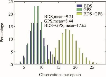
Fig.3 Visible navigation satellites from S1 and S2.
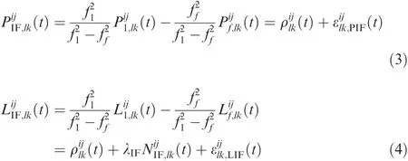

The IF combination observation can be written as Eq.(5)

where y is a vector with DD code and phase observations,b is a vector with unknown parameters of relative orbits,a represents ambiguities,e represents remaining error terms,A and B are the design matrices,and.Because the frequencies between BDS and GPS are different,the differential intersystem biases must be considered.Therefore,in this study,the double differences are formed with one reference satellite per system.The ambiguities of each system are solved individually.Firstly,the floating-point solution is obtained by Eqs.(6)and(7)


Finally,the improved relative orbit estimatorscan be obtained by

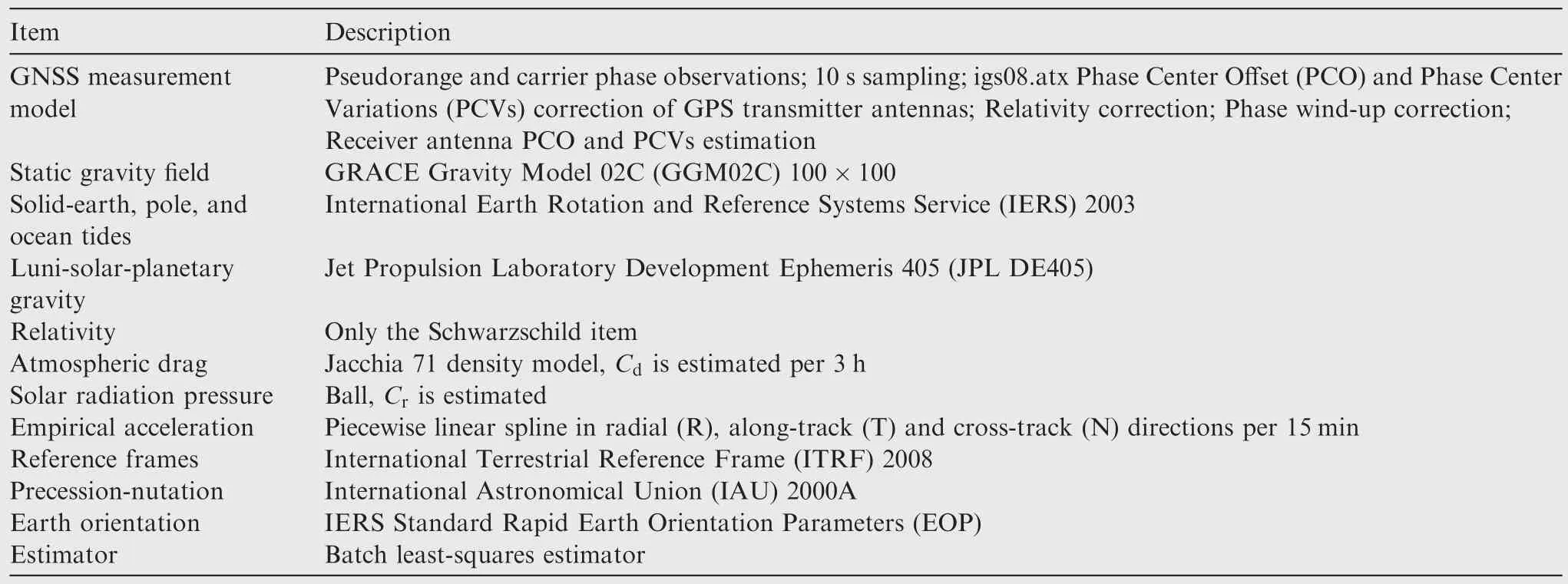
Table 3 Summary of dynamical and measurement models used for GNSS-based precise baseline determination in NUDDTK.
All of the experiments in this study were carried out using the National University of Defense Technology Orbit Determination Toolkit(NUDTTK)software,which has successfully processed dual-frequency GPS data from LEO satellites,e.g.GRACE and the Shiyan 3 satellite.21–24A summary of the dynamical and measurement models used for the GNNS-based precise baseline determination is given in Table 3.The parameters to be estimated are ambiguity parameters of the phase IF combination,initial satellite position and velocity vector,solar pressure coefficient Cr,piecewise constant atmospheric drag coefficients Cd,and the empirical acceleration vector.
3.Results and analysis
3.1.Influence of observation noise
PROD’s accuracy is highly affected by observation noise.Table 4 shows the PROD results of S1 and S2 over 15 days,considering only the observation noise.PROD’s results are the RMS of the difference between the reference orbits and the determined relative orbits.As described in Table 4,the average accuracies of PROD,based on BDS-only,GPS-only,and BDS+GPS,are 0.74 mm,0.66 mm,and 0.52 mm over 15 days,respectively.Compared to BDS-only and GPS-only,PROD’s accuracy increased by 29.73%and 21.21%,respectively,after BDS and GPS are combined.BDS provides an independent method for achieving PROD results,which corresponds to the results based on GPS,and will improve the reliability of PROD based on GPS-only.We can test the PROD results by comparing the relative orbit based on BDS-only and GPS-only,identifying the period in which the residual is larger than normal,and alerting users that the relative orbit may not be reliable during those periods.
Furthermore,to analyse the spatial distribution of the PROD accuracy based on BDS-only,GPS-only and BDS+GPS,the mean 3D accuracy of each 5°×5°zone is calculated(see Fig.4).A millimetre precision can be available based on BDS-only or GPS-only(see Fig.4(a)and(b)).Nevertheless,the accuracy of PROD based on GPS-only is slightly higher than that based on BDS-only,which probably results from the layout differences between BDS and GPS.BDS is a mixed navigation constellation with 35 navigation satellites,but it has only 27 MEO satellites distributed over three orbits.All 32 GPS satellites are MEO satellites,and they are evenly distributed over six orbits.In addition,Fig.4(a)shows that the differences of the PROD results based on BDS-only are not apparent between different regions,compared with the BeiDou-2 system.18It follows that BDS could provide precise global relative orbits for LEO formation- flying satellites.Obviously,the PROD results over the globe have greatly improvedby combining BDS and GPS(see Fig.4(c)).This implies that integrating BDS and GPS can effectively reduce the impact of random noise and improve the accuracy and reliability of PROD.

Table 4 PROD 3D results of S1 and S2 in 15 days.
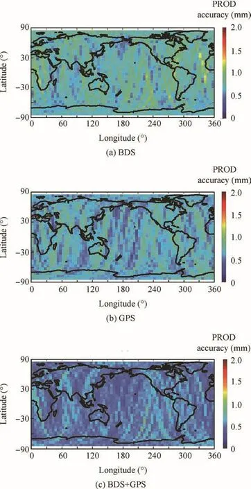
Fig.4 Global distribution of PROD 3D accuracy of S1 and S2.
3.2.Contribution of GEO and IGSO
The global visible BDS satellites over the Asia-Pacific region are obvious in the majority.Fig.5 shows that the PROD accuracy of the radial(R),along-track(T),and cross-track(N)components are 0.26 mm,0.51 mm and 0.43 mm,respectively,in the Asia-Pacific region,and they are 0.26 mm,0.55 mm,and 0.43 mm,respectively,in the non-Asia-Pacific region.As can be seen from Fig.5(a)and(b),the difference in accuracy over the two areas is quite small.GEO satellites and IGSO satellites are only distributed over the Asia-Pacific region;however,this does not cause PROD’s accuracy to differ from region to region.Therefore,the contributions of GEO satellites and IGSO satellites to PROD are discussed in this section.
Fig.6 shows the PROD accuracy of S1 and S2 based on MEO-only and GEO+IGSO+MEO over the Asia-Pacific region and the non-Asia-Pacific region.When MEO satellites co-worked with GEO satellites and IGSO satellites,PROD’s accuracy increased from 0.82 mm to 0.74 mm globally(see Fig.6(a)).In addition,the accuracy over the Asia-Pacific region and the non-Asia-Pacific region increased by 14.29%and 7.41%,respectively(see Fig.6(b)and(c)).This suggests that GEO satellites and IGSO satellites could positively affect the accuracy of PROD over the globe.Increasing the observations over the Asia-Pacific region could enhance the constraint of the batch least-squares,and the accuracy over the globe could improve.However,because the satellites are only distributed over the Asia-Pacific region,the improvement inside the Asia-Pacific region is slightly higher than that outside.
3.3.ADOP results and analysis
From Eq.(9),we know that PROD’s accuracy is directly related to the success rate of the integer ambiguity.However,the success of the ambiguity resolution depends on the quality of the float ambiguity estimates.The more precise the float ambiguity is,the higher the probability of estimating the correct integer ambiguities is.25The Ambiguity Dilution Of Precision(ADOP)(see Eq.(10))can be used to obtain insight into the quality of the ambiguities.It is defined such that it is invariant for the class of admissible ambiguity transformations,and it captures both the precision and correlation characteristics of the ambiguities.26

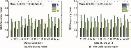
Fig.5 PROD accuracy of S1 and S2.
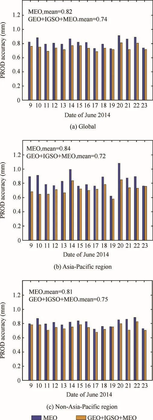
Fig.6 PROD results of LEO satellite S1 and S2 with and without GEO and IGSO.
The value of ADOP depends on the number of visible satellites and the quality of their observations,which is a constant when the ambiguity-resolution model remains unchanged,and ADOP gives the average accuracy of the ambiguity resolution.Thus,it can be used as a precision index to evaluate the success rate of the integer least-square ambiguity resolution.This section uses ADOP to analyse the improvement of the integer ambiguity resolution caused by integrating BDS and GPS.
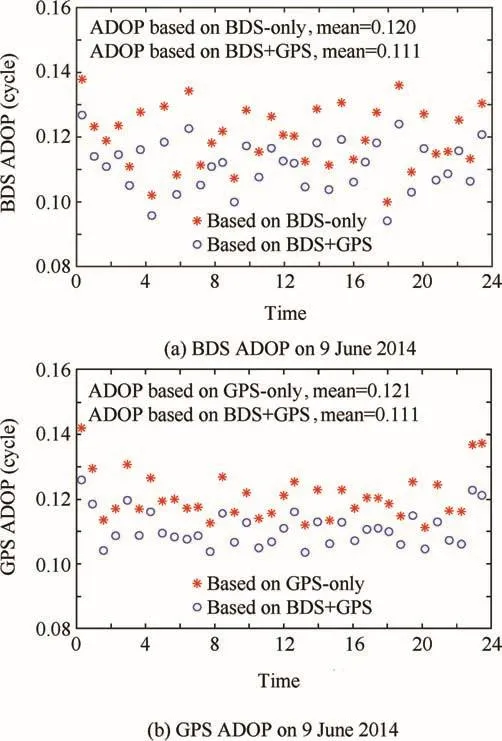
Fig.7 BDS and GPS ADOP on 9 June 2014.
Fig.7 show the value of ADOP on 9 June 2014.When BDS co-worked with GPS,the BDS ADOP decreased from 0.120 to 0.111,while the GPS ADOP decreased from 0.121 to 0.111,with a decrease of about 7.50%and 8.26%,respectively.This indicates that integrating BDS and GPS can effectively improve the quality of the float ambiguity.When BDS coworked with GPS,the type,number and precision of the GNSS observations were increased,and the number and selection of frequencies were improved,all of which contributed to the success of the ambiguity resolution.Although the ambiguity per system was solved separately,the orbital parameters are the same.Integrating BDS and GPS will largely increase the observations,which will improve the accuracy of^b,and thereby improve the quality of the float ambiguity.
3.4.Influence of navigation satellites’ephemeris precision
In the PROD process,the ephemeris error can be reduced by the double-difference observations.However,the BDS ephemeris error is greater than that of GPS;especially,the ephemeris error of GEO satellites can reach several meters.27Therefore,the influence of navigation satellites’ephemeris precision on PROD is analysed in this section.The ephemeris error has a certain periodicity,which is equal to the orbital period.Therefore,for navigation satellites j,the ephemeris errors djare obtained from Eq.(11),where the value of σjis shown in Table 5,27Tjis the orbital period,and φjis a random number ranging from 0 to 2π.

Table 6 shows that the results of PROD,with and without ephemeris errors,are almost identical.This implies that the influence of ephemeris errors on the PROD results of S1 and S2,based on BDS-only,GPS-only,and BDS+GPS,can be ignored.Furthermore,the upper limit for the SD ephemeris errors is determined with Eq.(12)1:
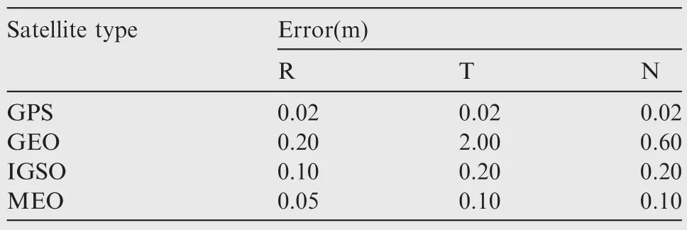
Table 5 Errors added to ephemeris.

where rland rkare the positions of GPS receivers l and k,respectively,rjis the position of navigation satellites j,and εrjis the ephemeris errors of navigation satellites j.The upper limit for the SD ephemeris errors is·.The average distance between S1 and S2 is about 2 km.The minimum distance between S1 and a GEO satellite is about 35,000 km,so the upper limit for the SD ephemeris errors of GEO satellites is only about 0.1 mm.Similarly,the values of the IGSO and MEO satellites are about 0.02 mm and 0.015 mm,respectively;the GPS satellite error is much smaller than either.Therefore,when the relative position between the LEO satellites is only a few kilometres,the effect of ephemeris errors on PROD can be ignored.
However,the values will change if the distance between the LEO satellites increases to 200 km while the altitude remains the same.According to Eq.(12),the upper limits for the SD ephemeris errors of GEO satellites,IGSO satellites and MEO satellites are approximately 10 mm,2 mm,and 1.5 mm,respectively.For example,the average distance between S1 and S3(see Table 2)is about 200 km.Fig.8(a)shows the results without the ephemeris error.The accuracy of PROD based on GEO+IGSO+MEO is slightly higher than that based on IGSO+MEO.However,when the ephemeris errors were considered,and IGSO+MEO co-worked with GEO,the accuracy of PROD decreased from 0.94 mm to 1.10 mm,with a decrease of about 17.02%(see Fig.8(b)).
In addition,Fig.9 shows the SD ephemeris error of GEO satellites,IGSO satellites,and MEO satellites on 9 June 2014.Because the SD ephemeris errors of the same kind of satellite are almost the same,each satellite type is only listed once.As can be seen in Fig.9,the maximum SD ephemeris errors of the MEO and IGSO satellites are about 2 mm,and the average is less than 1 mm.However,for GEO,the maximum is about10 mm,and the average is about 4 mm,which must be taken into consideration.As there are 27 MEO satellites and only 5 GEO satellites,the ephemeris errors of the GEO satellites do not result in centimetre-level errors.However,when using BDS to determine the relative orbit of LEO formation flying in the future,different weights should be established for the different satellites to reduce the influence of the ephemeris errors.
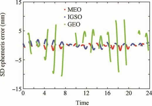
Fig.9 SD ephemeris error on 9 June 2014.

Table 6 PROD results of S1 and S2 with and without ephemeris error.
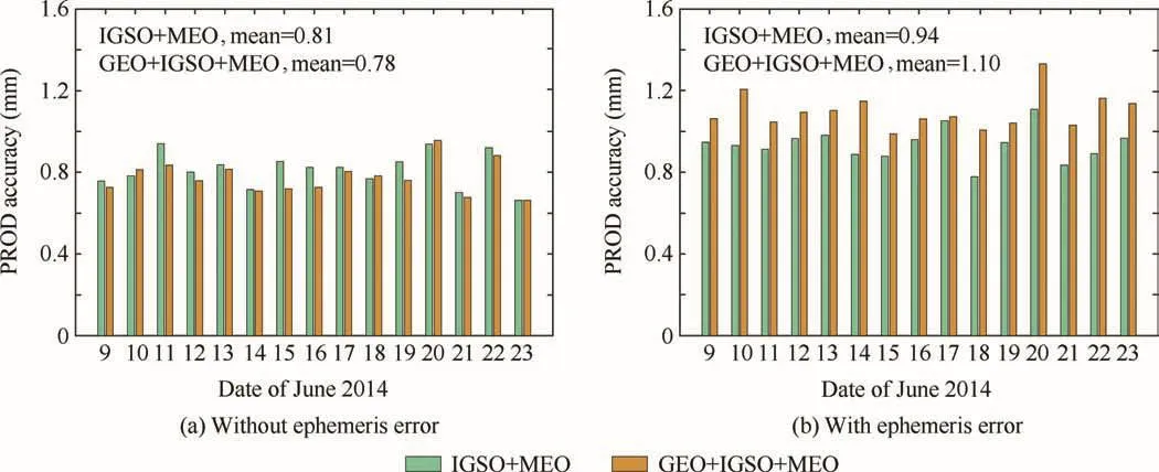
Fig.8 PROD results of S1 and S3.
4.Conclusions
(1)The high-speed movement of LEO satellites is mainly responsible for the unreliability of the PROD method based on GPS,and the development of BDS provides new opportunities to improve PROD’s accuracy and reliability for LEO formation flying.Therefore,the contribution of BDS to the accuracy and reliability of PROD for LEO formation- flying satellites was investigated in this study.
(2)Compared to BDS-only and GPS-only,the average number of visible navigation satellites at altitude of 500 km,based on BDS+GPS,improved by 81.80%and 122.25%,respectively.The average observations from LEO satellites S1 and S2 increased from 9.21 and 8.44 to 17.65.
(3)The accuracies of PROD,based on BDS-only,GPS-only,and BDS+GPS,were 0.78 mm,0.66 mm,and 0.54 mm,respectively.They increased by 29.73%and 21.21%,for BDS-only and GPS-only,respectively,after BDS and GPS were combined,if only the observations’noise was considered.
(4)In addition,when MEO satellites co-worked with GEO satellites and IGSO satellites,the accuracy over the Asia-Pacific region and the non-Asia-Pacific region increased by 14.29%and 7.41%,respectively.It follows that GEO satellites and IGSO satellites could have positive effects on improving the accuracy of PROD around the globe.
(5)The ADOP result indicates that integrating BDS and GPS can improve the quality of the float ambiguity.When BDS co-worked with GPS,the ADOPs of BDS and GPS decreased by about 7.50%and 8.26%,respectively.This indicates that integrating BDS and GPS can effectively improve the quality of the float ambiguity and PROD’s accuracy.
(6)If the distance between the LEO satellites increased to 200 km,and IGSO+MEO co-worked with GEO,the accuracy of PROD would decrease by~17.02%.The maximum SD ephemeris error of the GEO satellites was~10 mm.This suggests that when BDS is used for PROD,different weights should be established for different satellites to reduce the influence of the ephemeris error.This will be studied further in the future.
Acknowledgements
This study was supported by the National Natural Science Foundation of China(Nos.91438202,61370013).
杂志排行
CHINESE JOURNAL OF AERONAUTICS的其它文章
- Guide for Authors
- Electrochemical machining of a convex strips structure on a revolving part by using site directed power interruption
- Postcapture stabilization of space robots considering actuator failures with bounded torques
- A multi-index assessment method for evaluating coverage effectiveness of remote sensing satellite
- Training effectiveness evaluation of helicopter emergency relief based on virtual simulation
- Turbulent characteristics and rotation correction of wall function in rotating channel with high local rotation parameter
