Assessment of trace metals contamination in stream sediments and soils in Abuja leather mining,southwestern Nigeria
2018-08-30AbiolaOyebamijiAdegbolaOdebunmiHuRuizhongAttaRasool
Abiola Oyebamiji•Adegbola Odebunmi•Hu Ruizhong•Atta Rasool
Abstract This study is aimed at determining the level of environmental degradation as well as the concentration of trace elements in soil and stream sediments in order to evaluate the environmental impact of the mining operation.Twenty- five(25)soils and ten(10)stream sediment samples were collected from the study area.The physicochemical parameters were determined using appropriate instrumentation with the aid of a digital pH meter(Milwaukee meter)to measure the pH and electrical conductivity,total dissolved solids,moisture content and loss on ignition of the soil and stream sediment samples.The pH of the soil sample ranged from(6.10 to 7.19);Electrical conductivity ranged from(21.3 to 279.4 μS/cm),moisture content varied from(0.60%to 7.20%),and the LOI ranged from(2.03%to 18.62%).The results of the analysis showed that the concentrations of the trace elements in the soils and stream sediment samples were slightly higher than the background values.Plots of the trace elements in stream sediment samples show moderate,consistent decrease downstream except at points where there was mine water discharge into the main river.The pollution levels of heavy metals were examined in stream sediment and soil samples using different assessable indices,such as the enrichment factor,which showed significant-moderate enrichment for Cr,Th,Nb,Zn,Pb,Y and Zr and the geoaccumulation index,which showed practically moderate contamination with Cr,Ni and Sr based on regional background reference values.Geo-accumulation index and contamination index for soils and stream sediment revealed uncontaminated to moderate contamination.Likewise,elements with moderate contamination were Cr,Ni and Sr.The Pearson correlation showed that there were significant positive associations among selected metals in soil and stream sediment samples.
Keywords Trace metals·Stream sediments·Geoaccumulation index·PCA ·Soil·Southwestern Nigeria
1 Introduction
Mineral resources are an important source of wealth for many nations,including Nigeria,but before they are harnessed,they have to pass through the stages of exploration,mining,and processing(Adekoya 2003).In recent years,there have been concerns about significant environmental problems caused by the mining that domestic and foreign corporations are doing of rare and major metals and metallurgical activities in African countries(Oelofse 2008).Mining operations,which involve the extraction of minerals and ores beneath and at the surface of the earth,are considered to be accompanied by environmental degradation as well as environmental pollution and associated diseases as a result of some trace elements dispersed into the surrounding environment(Adriano 2001;Higueras et al.2004;Oelofse 2008;Lacatusu et al.2009;Kodom et al.2010;Sahoo et al.2014;Potra et al.2017).Although some of these trace elements are needed in minute amounts,they can have a severe environmental impact if found in high concentrations(elevated level)and can have adverse effects on all living things(Aigbedion 2005;Sheikh et al.2007;Zvinowanda et al.2009;Nakayama et al.2010).The overall variation in concentration of these trace elements can be attributed to the differential discharge of untreated effluents originating from industrial mining,increasing agriculture,and aquaculture sources(Chatterjee et al.2007;Binelli et al.2008;Achary et al.2016,2017).
The mobility and bioavailability of these trace elements in the environment greatly depend on some physical–chemical characteristics of the environment such as pH,textural characteristics,organic matter content,speciation or chemical form,and electrical conductivity(Teng et al.2008;Equeenuddin et al.2013).The overall variability of soil over the earth’s surfaces had been widely documented,and this occasionally leads to environmental and human problems when the abundance of some elements in soils is either too low or too high.Despite recognizing the variability and the geochemical importance of the chemical elements in soils,many countries(including Nigeria)still lack adequate geochemical information about their soils,stream sediments,and water,especially in the mining environment.
The overall impact of some trace elements in living organisms is directly related to their interactions with the soil and the geological,biological,and aquatic systems(Satpathy et al.2012;Ayari et al.2016;Kumar et al.2017).Sarkar et al.(2008),Chatterjee et al.(2009)and Jonathan et al.(2010)conducted biomonitoring of heavy metals in the aquatic system and assessment of trace elements contamination in intertidal sediments cores of Northern coast of Bay of Bengal,and they concluded that the concentration of all the metals in the aquatic system exceeded the safe levels according to the international standards for metals compiled by Food and Agricultural Organization of the United Nations.This water,therefore,would pose a significant risk should it be used for human consumption.Given the many sources,widespread distribution and multiple effects of heavy metals in the ecosystem,contamination of the environment by heavy metals has become not only a local phenomenon but also a global one as well(Neto et al.2000;Harikrishnan et al.2017).Hence,heavy metals have become significant variables within the framework of environmental pollution investigation.Therefore,geochemical studies of the mining site using sample media like soil,stream sediment,and water are fundamental in determining the distribution pattern of trace elements that are present and the level of the contamination effect on the immediate environment by the mining activities.Chemical partitioning should be adequately used in the assessment of environmental degradation caused by a significant amount of heavy metals and trace elements which may occur naturally as anthropogenic fractions within the soils and stream sediments(Sarkar et al.2014;Harikrishnan et al.2017).
Abuja Leather mining activities operation began over 15 years ago,and it is known for mining tantalite,tin,niobium,gemstones,from mineralized pegmatite veins.The district is located in the southwestern part of Nigeria and is one of the productive pegmatite field known to bear valuable economic minerals,which are associated with granite gneiss.Mineralization is limited to the pegmatites,which are moderately weathered in the prospect zones.These streams of pegmatitic veins are semi discordant,and they mainly contain quartz,muscovite,mica-plagioclase(albite),and microcline as the main minerals while tourmaline and beryl occur in minor amounts(Akintola et al.2012).The study is aimed at determining the trace elemental concentrations in soils and stream sediments of the study area in order to identify the level of metal pollution and the source of heavy metal contamination.To this end,there is the need for instituting a systematic and continuous monitoring of trace elements and other forms of pollutants to determine their spatial distribution and concentration in soils and other sample media.
2 Materials and methods
2.1 Study area description
The Abuja Leather mining site is situated in the Northwestern part of Komu town southwestern Nigeria,which lies within the coordinates longitude 08°15′to 08°18′N and latitude 002°58′to 003°03′E covering an area extent of 85 km2(Federal Survey of Nigeria 1964)(Fig.1).The study area is poorly accessible,but there is a minor road created by the miners during their quest to find their mineral of interest.The area is characterized by dense vegetation,and the ease of accessibility was achieved using cutlass to make footpaths.The study area is situated within the tropical rainforest belt with a climate characterized by an alternation of dry and wet seasons.The rainy season runs from April through October when the effect of the south-west monsoon wind overwhelms that of the northeast trade wind which usually causes dry seasons from November to April.The wet season is characterized by heavy rainfall with corresponding low temperatures while the dry season comes with high temperatures and little or no rain.Annual rainfall varies from 2000 mm in the southern areas to 1150 mm in the northern areas.The annual mean temperature ranges from 21 and 29°C while the relative humidity ranges from 27.5%and 98.2%(Olujumoke et al.2016).The elevation of the study area varies between 190 and 300 m above sea level.The area is drained by River Oyan,and virtually all tributaries dry up during the dry season.Moreover,the deforestation of fields during the mine development may have caused the elimination of some plants and the exodus of some animals that feed on such plants or depend on them for cover,from the affected area.Mining operations frequently upset the equilibrium in the geological environment,which may trigger certain geological hazards such as landslides,subsidence, flooding,erosion,and tremors,along with their secondary effects.Minor earth tremors are generated due to the blasting of rocks in various quarries.Eventually,mine abandonment is imposed by depletion of the available reserves,often leading to the migration of people from the mining areas to other places.
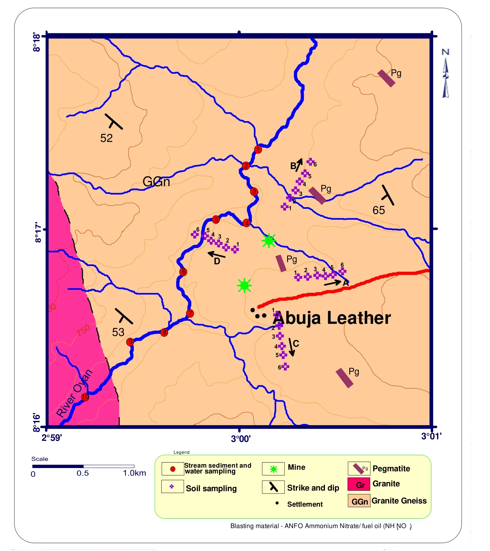
Fig.1 Location map showing sampling pattern superimposed on the geologic map
Nigeria is underlain by Precambrian basement complex rocks,younger granite of Jurassic age,and Cretaceous to Recent sediments(Rahaman 1988;Dada 1989).The basement rocks occupy about half of the land mass of the country and is a part of the Pan-African mobile belt lying between the West African and Congo cratons(Elueze 2000;Obaje 2009).The Abuja Leather mining district is located within the basement complex of southwestern Nigeria,and it began its operations for over 15 years ago.Rare minerals such as tantalite,tin,niobium,columbite,and gemstones are mined from mineralized pegmatite veins hosted within granite-gneiss(mesocratic and mediumgrained).These pegmatites occur as coarse-grained rocks and mainly trend in the NNW-SSE direction.The background site has the same geological features as that of the mining site,and soil samples were taken in an undisturbed area at a distance about 3 km west of the mining site.
2.2 Sampling pattern and analysis
Proper delineation of the mining sites was done during the reconnaissance survey,and a systematic sampling pattern was employed as shown in(Fig.1).Twenty- five(25)soil samples were carefully collected at depth 1–15 cm and an interval of 100 m along traverse lines in four cardinal directions with reference to the mining site.With this spread,a total of six(6)samples of appreciable weight were obtained in each direction and stored in clean polyethene bags.One control sample was taken almost 3 km west of the mining site.Ten(10)samples of stream sediments were collected along River Oyan.The stream sediments were taken at the precise points of collection by hand scooping and stored in clean,labeled polythene bags.Compass clinometer was used for direction on the field as well as in measuring orientations of various structural features of the outcrops.The GPS was used to locate exact positions and elevations of sampling points while a geological hammer was used in breaking and chipping fresh samples from the exposed rocks for closer observation.All information was recorded in a field notebook.A digital camera was used in taking the pictures of any salient and diagnostic features found on different lithology.The plastic sieve was used in sieving out the dirt and stones from the soil samples before sampling.A stainless-steel hand trowel was used in scooping out soils from the ground while plastic bucket was used to scoop sediments from the river base as well as take water from the middle course of the river.The already air-dried soil samples and stream sediment samples were sieved through a series of different mesh sizes to obtain<0.075 mm fraction to remove roots,coarse materials,stones,and other unwanted debris in order to obtain the clay-sized fraction for geochemical analysis.The choice of this clay fraction was because the f i ne sediment(clay/silt fractions),as a result of their net negative charges,do participate in cation exchange processes,so this serves as a good metal accumulator.In determining the pH of the samples,50 g of the air-dried samples were transferred into a 200 ml beaker,and 100 ml of distilled water was gradually added and left for 20 minutes to facilitate water movement through the soil.The mixture was later occasionally stirred with a glass rod and allowed to stand for 24 h.The pH meter was also standardized with a buffer solution of pH 7.0,after which the electrode was dipped into the prepared samples.This process was done for all the samples.The temperature at which the pH was measured was also recorded.The electrode was dipped into the sample solutions used for the determination of pH,the knob of the conductivity meter was turned,and the value was recorded in millisiemens cm-1(μS/cm).
All chemical analyses of the soils and stream sediments were carried out by a certified commercial laboratory in Canada(ACME Laboratories,Canada).Samples were dried in the open air for 5 days,crushed by hand in a porcelain mortar,and sieved through a 2 mm screen.Airdried<2 mm samples were stored in plastic bags for subsequent analysis.The samples were later placed in a container and properly labeled,then finally sent to laboratories for analysis.The method of digestion adopted was after a near total absorption by hydro fluoric-perchloric acid.The major,trace and rare earth elements in the stream sediments were analyzed using inductively coupled plasma-mass spectrophotometry(ICP-MS).The accuracy of the analytical methods was monitored by the repeated analysis of standard reference materials done together with a batch of sediment samples according to the technique of Dulski(2001).These data gave satisfactory results,with analytical values within± 1%–10%for different elements.
2.3 Pollution indices
World average concentration of metals reported by Benhaddya and Hadjel(2014)was used as background values for heavy metals(Cr,Co,Ni,Cu,Cd,Zn,Fe,Pb,and Li).This is an expression of the level of contamination of soil by metals is expressed by the formulae below;Contamination Index=Cm/Bm
where Cm and Bm are the concentration of the metal in the sample and background respectively.
Geo-accumulation index(Igeo)was developed by Muller(1981)and had widely been used in trace metal studies of sediments and soils as discussed in Sekabira et al.(2003),Gong et al.(2008),Rapant et al.(2008),Zoynab et al.(2008),Amin et al.(2009),Silva Filho et al.(2011),Bramha et al.(2014)and Odukoya and Akande(2015).To quantify the degree of heavy metal pollution in Lanmuchang Riversediments,Igeo was calculated according to Muller and is given in Eq.(2).The geo-accumulation index(Igeo)was originally defined by Muller(1981)to determine and define metal contamination in sediments(Banat et al.2005;Antunes et al.2017),by comparing current concentrations.It is expressed as;
Igeo=Log2{(Cm)/(1 .5*Bm)}
where Cm is the concentration of metals in the study area,Bm is the concentration of the same metal at the control site,and 1.5 is a factor for possible variation in the background concentration due to lithological variation.
2.4 Data treatment
The results of the chemical analyses were subjected to statistical analyses such as descriptive analysis,Pearson correlation,Coefficient of variation and R-mode factor analysis using Excel and SPSS Windows 15.0.Arc GIS and Arc-View were employed in the production of geologic mapping while some contamination indices such as Geoaccumulation index(Igeo)and contamination index were used in evaluating the environmental implications of the trace element contents in soils and stream sediments samples of the study area.In carrying out cluster analysis,the selected variables were analyzed,the distance measure was selected,and all variables to be analyzed were standardized.The hierarchical cluster analysis was represented as a dendrogram.These figures illustrate which groups joined at each stage of the analysis and the distance between clusters at the time of joining.The presence of a significant jump in the distance between the clusters from one stage to another suggests that at one stage,clusters that are relatively close together were joined whereas,at the following step,the clusters that were joined were fairly far apart.
3 Results and discussions
3.1 Physico-chemical properties of soil and stream sediment samples
The soil pH played a significant role in the mobility of metals and availability of metals to plants.Low soil pH values often significantly increased metal mobility while high soil pH values decreased the mobility of metals.The pH values for the soil ranged from 6.10 to 7.19,and this indicates that the soils were slightly acidic to slightly alkaline which can be attributed to the following factors:metal absorption properties,metal hydrolysis,and acid catalyzed dissolution of oxides.The pH values of the stream sediment ranged from 7.0 to 7.8 hence,slightly alkaline,and this may be caused by temperature variations and acid buffering effects with dissolved organic species.The electrical conductivity(EC)values for the soil samples ranged from 21.3 to 279.4 μS/cm,while the values of EC for the stream sediments ranged from 150.2 to 324.4 μS/cm,and this is an indication of the presence of dissolved ions in the stream water at points of collection,high concentration of dissolved solids and the effects of rainfall,runoff,and evapotranspiration.The measured data suggested that there was no uniform pattern of distribution in the values of electrical conductivity in soil and stream sediments.The values of total dissolved solids(TDS)fell between 16.0 and 209.6 mg/L in soil samples while the values in stream sediments ranged from 112.7 to 243.3 mg/L(Table 1).The primary elements included magnesium,sodium,potassium,aluminium,iron,calcium,titanium and phosphorus.In the soil samples,aluminium has the highest percentage concentration ranging from 2.06%to 9.51%,iron has the second highest percentage concentration ranging from 2.84%to 6.25%.The percentage concentrations of calcium ranged from 0.16%to 2.76%,phosphorus from 0.01%to 0.11%,sodium from 0.12%to 1.92%,potassium from 0.53%to 2.72%,magnesium from 0.10%to 1.31%and titanium from 0.57%to 2.62%.The observed order of increase in magnitude of the mean content of the major oxides concentrations in the study area is as follows;Al>Fe>K>Ti>Ca>Na>Mg>P.Oxygen and Silicon are the most abundant elements found in Earth’s crust followed by Aluminum and Iron in this order(O>Si>Al>Fe>Ca>Na>K>Mg).The mean percentage of aluminium was greater than that of iron from the result obtained.In the stream sediment samples,aluminium also had a higher concentration(5.62%–7.24%)compared to iron,whose concentration ranged from 4.43%to 6.54%.The percentage concentrations of calcium also ranged from 1.5%to 2.3%,phosphorus(0.055%–0.114%),sodium(1.15%–1.56%),potassium(1.49%–2.04%),magnesium(0.67%–0.96%)and titanium(1.21%–3.64%).The observed order of increase in magnitude of the mean content of the major oxides concentrations in the study area is as follows;Al>Fe>Ti>Ca>K>Na>Mg>P(Table 1).
3.2 Assessment of trace metals in soils and stream sediments
The geochemical result of the concentration of selected trace elements in the top soils and stream sediments around the Abuja Leather mining site are presented in Tables 2 and 3.A total of 25 samples of soils were analyzed for their metal contents(Table 2).These metals include Cu,Pb,Mo,Zn,Ag,Ni,Co,Mn,As,U,Au,Th,Sr,Cd,Sb,Bi,Zr,V,La,Cr,Ba,B,Y,Nb,Be,Fe,and W.The results of Mo,Ag,U,Au,Sb,Bi,S,Sn,and W were found to be below detection limits in most of the samples analyzed,and hence were screened out.Results for the metals were measured in ppm,and some were expressed in percentages,as presented.The concentration of the trace elements in the soils ranged from:Cu(13–93 ppm),Pb(5–33 ppm),Zn(22–75 ppm),Ni(11–101 ppm),Co(5–84 ppm),Mn(388–4647 ppm),Th(4–31 ppm),Sr(43–470 ppm),Cd(BDL—1.80 ppm),V(62–176 ppm),La(22–71 ppm),Zr(53–145 ppm),Cr(79–226 ppm),Ba(197–2100 ppm),Sc(7–30 ppm),Nb(10–53 ppm),Fe(2.84%–6.25%)and Y(10–66 ppm).The average results of the trace elements concentration observed showed a decreasing order of magnitude as in Fe>Mn>Ba>Sr>V>Cr>Zr>Ni>V>Zn>Cu>Y>Co>La>Nb>Th>Sc>Pb>Cd.The mean concentration of Cr,Cu,Mn,Co,Ni,Cd,Ba,Sr,Sc,V and Fe have their concentration exceed that in the control sample(sample collected where there were no mining activities taking place)while Pb,Zn,Th,Nb,Zr and Y have their concentration below that in the control sample.
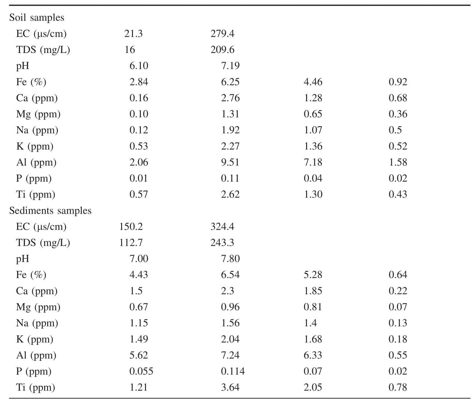
Table 1 The summary of physicochemical parameters Elements Minimum Maximum Average Standard deviation
A total of 10 samples were taken along River Oyan and analyzed for their metal contents(Table 3).Some of the elements(Cu,Pb,Zn,Ni,Co,Mn,Th,Sr,Cd,Zr,V,La,Cr,Ba,B,Y,Nb,Be,and Fe)detected in the soil samples listed in Table 2 were also present in the analyzed stream sediment samples(Table 3).The range of trace elements’concentration in the stream sediment samples are Cu(15–31 ppm),Pb (5–31 ppm),Zn (45–31 ppm),Ni(25–42 ppm),Co(23–35 ppm),Mn(1727–3730 ppm),Th(11–47 ppm),Sr(178–287 ppm),Cd(1–1.80 ppm),V(122–174 ppm),La(22–71 ppm),Cr(83–135 ppm),Ba(548–769 ppm),Sc(13–15 ppm),Zr(83–215 ppm),Nb(28–100 ppm),Fe(4.43%–6.54%)and Y(23–34 ppm).The average results of the trace elements concentration observed showed a decreasing order of magnitude as in Mn>Ba>Sr>Zr>V>Cr>Nb>La>Ni>Th>Zn>Cu>Y>Co>Pb>Sc>Cd.
The mean concentration of some trace elements was compared with the average shale,the calculated background for the elements in the study area,the average content of sediments around the Itakpe iron mining site(Okunlola and Ocan 2002,Okunlola and Olaperi 2006),the average content of Gomati River sediments(Singh et al.1997)and the average content of Neckar River sediments(a tributary of Rhine River in Germany)(Muller et al.1993).Since trace elements like Ba,Sr,Th,Nb,Zr,Y,V,and Sc do not really have any significant environmental impact,their values from the literature were not established.However,the values of toxic trace elements such as Cr,Pb,Zn,Cu,Mn,Co,Ni,Cd and Fe are well stated and were compared with the result obtained from the geochemical analysis of the study area.The concentration of the trace elements in the stream sediments within the study area was in agreement with the average shale values except for Zn(130.3 ppm),Mn(2484.1 ppm),Co(26.7 ppm)and Cd(1.5 ppm),which showed enriched values.The concentrations of Cr,Zn,Mn,Co,Ni,and Fe in the stream sediment of the study area were greater than the Iron ore mining site in Itakpe.Comparisons with other deposits show lower values in the concentration of trace elements in the study area except for Mn and Co.
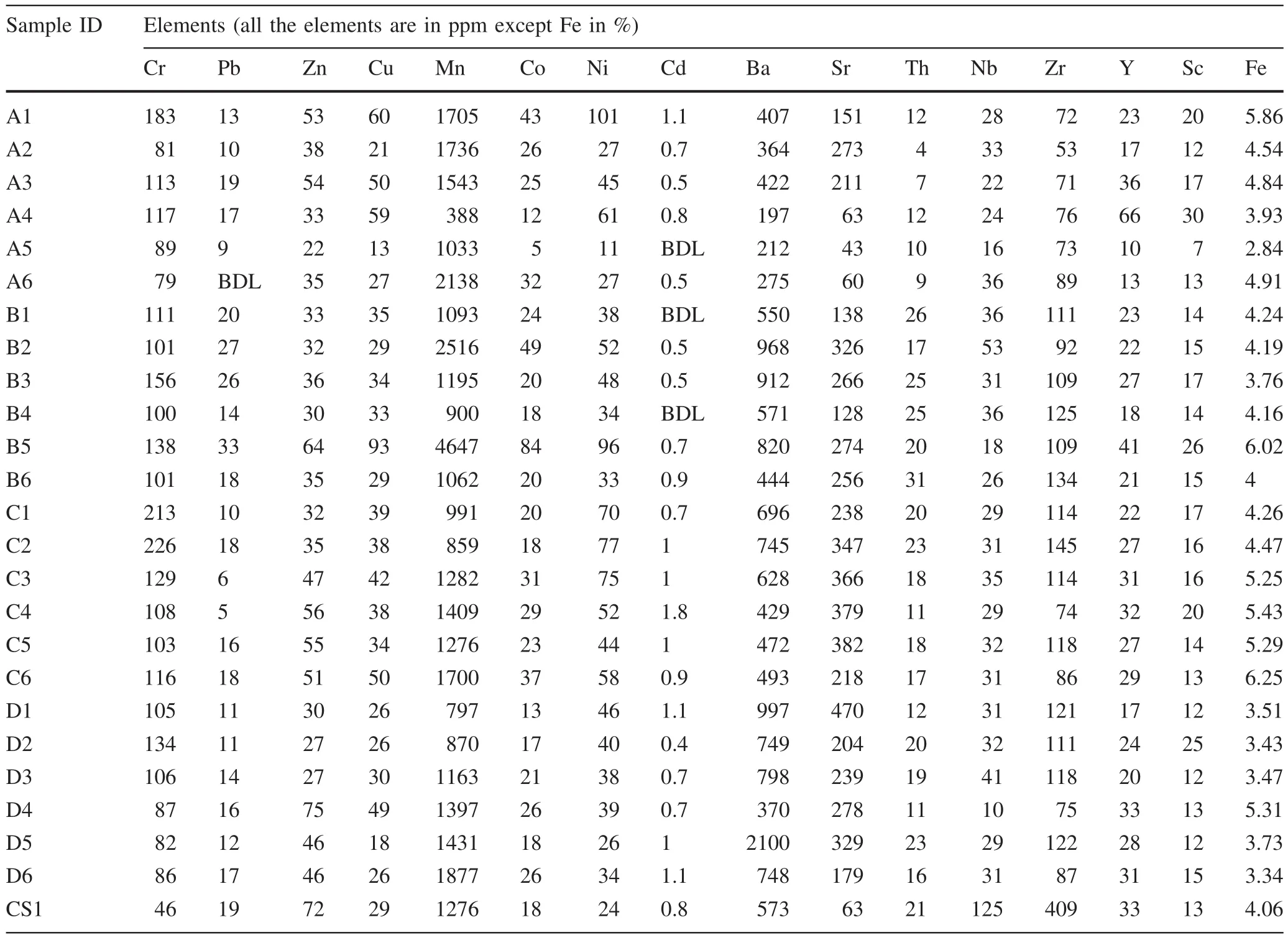
Table 2 Geochemical data of selected elements in soils of the study area
3.3 Variation plot for soils and stream sediments
Variation plot is the concentration-distance plot of elements obtained in the soils.It gives the dispersion pattern of each element as it moves through a particular distance along the sampling profile.Since the area is known for mineralization,the random variation in concentration of elements might be as a result of suspected local enrichment.The concentrations of trace metals in the variation plot for all the samples of soils and stream sediments were shown in Fig.2a–h.To evaluate the effect of the mining site on the environment,trace elements concentration ought to reduce away from the point source(the mining site).Some of the trace elements show this trend while some show haphazard concentration levels in different directions.In the eastern part of the mine,Cr,Ni,Zn,Cu,Ba,and Y show random signatures that have initial high concentrations but drop at 100 m away from the mine,then show a slight increase at 200 m but fall afterwards.The increase observed at 200 m was not as high as the one observed at the first sampling point,which still indicates that there is an effect of the mine in this direction.Sr shows initial low concentration,but the chemical signature follows the typical trend as it decreases from the second sampling point to the last(Fig.2).
Variation plot is the concentration-distance plot of elements obtained in the stream sediments of the study area.It gives the dispersion pattern of each element downstream.The general trend is that element concentration,as expected,decreases downstream.However,at various points along the stream course,there is an upsurge in the concentration of some elements.This is probably due to input from the tributaries adjoining the mainstream channels.Fluctuation in the content of metals from one sampling point to another is a result of many factors like absorption of elements,water velocity,and grain size fraction.
There was an upsurge of values in the concentration of trace elements between sample 5 and sample 8.This portion downstream was where water pumped out of the mine was discharged into River Oyan.As a result,sedimentstrapped within the mine water tended to settle when the condition was favorable and had an impact on the chemistry of the river sediment.In the northern part relative to the mine,Cr,Co,Ba,and Sr showed erratic variation in their concentrations while Pb,Ni,Zn,and V had their respective concentration highest at 400 m away from the mining site.The effect of this mining site was not apparent in this direction as a haphazard signature was observed.At the southern part,the dispersion of elements followed the average expected trend,i.e.decreased away from the point source(mining site)although there were minor variations along the sampling profile.Sr displayed slight deviation from the normal dispersion trend by slightly increasing from the first sampling site till 400 m and decreasing afterwards.The western part showed a similar pattern as observed in the south but elements like Zn,Cu,Co,and Ba had a concentration that was highest between 300 and 400 m away from the point source and that later showed a decrease at 500 m(Table 4).
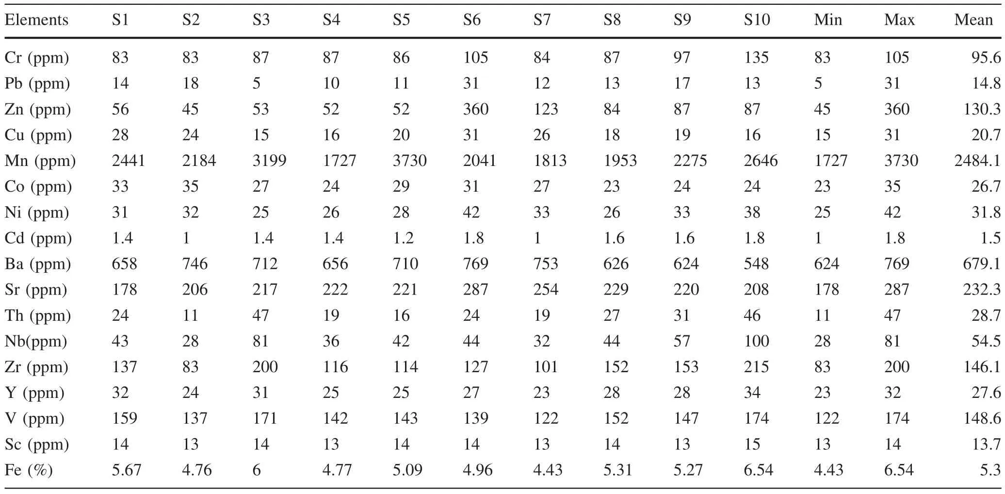
Table 3 Geochemical data for selected elements in stream sediment analysis
3.4 In dices of contamination and environmental effect
The contamination index of the study area was also undertaken to determine if there is an environmental effect of metals as a result of mining activities within the study area.The evaluation was done using the contamination index and geo-accumulation index.The contamination index was obtained by comparing the observed heavy metal concentration with the control values for soil and calculated background value for stream sediment.The control sample of soil was picked in an undisturbed location at about 3 km westward from the mining site which was analyzed,and the concentration of the elements therein was used as background values while the background values utilized for the stream sediment were calculated,which is the geometric mean of the concentration of the elements.Where the contamination factor CI values was less than 1.5,this indicates that the occurrence of metal was due to natural processes.However,where it was greater than 1.5 suggests that it was due to anthropogenic sources(Zhang and Lui 2002;Ljung et al.2006;Odewande and Abimbola 2008;Gopal et al.2017).
Tables 5,6 show the values for contamination index for soil and stream sediments,respectively.The values of the contamination index of various trace elements in soil is summarized in Table 5,such as:Cr(1.7–4.9),Pb(0–1.7),Zn(0.3–1.0),Cu(0.4–2.1),Mn(0.3–3.2),Co(0.3–4.7),Ni(0.5–4.4),Cd(0–2.3),Ba(0.3–3.7),Sr(0.7–7.5),Th(0.2–1.2),Nb(0.1–0.4),Zr(0.1–0.4),Y(0.3–1.2),Sc(0.5–2.3),V(0.7–2.0),and Fe(0.7–1.5).Values derived for Zn,Pb,Th,Nb,Zr,Y and Fe indicate that their mode of occurrence was due to natural processes,i.e.they are geogenic.Mn shows some degree of anthropogenic input at the northern part of the mining site.Cu has evidence of slight anthropogenic input at some points in the east,south,and north of the mining site but relatively free from such input at the south.Cr,Ni,and Sr have their contamination index values greater above 1.5,and this suggests they are anthropogenically contributed into the soil(Zhang and Lui 2002).Cr had its highest point of contamination at the second sampling point in the southern part of the mine.Sr had its highest contamination value to be 7.5 at the first sampling point to the east of the mine.
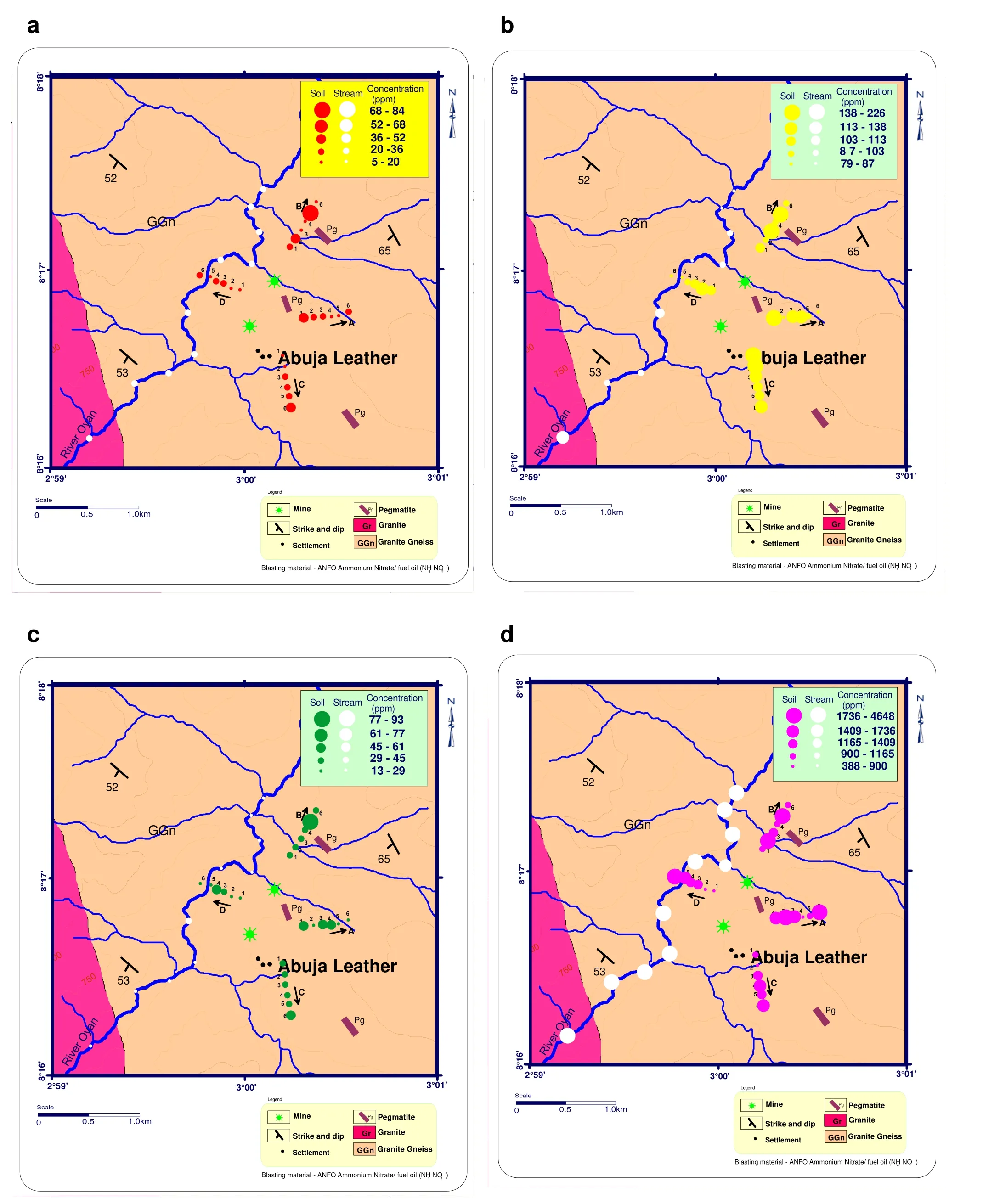
Fig.2 a–h Plots of cobalt,chromium,copper,manganese,nickel,lead,zinc and strontium concentrations in the study area
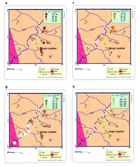
Fig.2 continued
The values of contamination index of various trace elements in stream sediments are summarized(Table 6)thus:Cr(1.0–1.6),Pb(0.4–2.4),Zn(0.5–4.3),Cu(0.8–1.6),Mn(0.9–1.6),Co(1.0–1.5),Ni(0.8–1.4),Cd(0.8–1.5),Ba(0.9–1.2),Sr(0.8–1.3),Th(0.5–2.0),Nb(0.8–2.4),Zr(0.7–1.9),Y(1.0–1.4),Sc(1.0–1.2),V(0.9–1.2),and Fe(1.0–1.4).Pb,Zn and Cu have their highest value 2.4,4.3 and 1.7 respectively at sampling point S6.This is the same sampling point where the water from the mine intercepts River Oyan.This suggests that the elements were introduced into the stream from the mining site.Cr,Th,Nb,and Zr have their peak contamination index values at the last sampling point,and this might have been contributed into the stream from adjoining tributary.
Interpretation with references to the seven-grade classification(Table 7)according to Muller(1969,1981)shows that the soils are unpolluted for most of the elements except for Cr,Ni and Sr with moderate enrichment(Fig.3).Cr have values that fall to moderately contaminated class at the first and second sampling points towards the south of the mining site;it also shows moderate contamination at the first sampling point in the eastern part of the mine.Ni shows moderate contamination at the first sampling point in the east part of the mine while Sr shows moderate contamination in the at the second and third sampling points in the east of the mining site while the north,south,and west of the mining site show moderate to heavy contamination in soil.The geo-accumulation index(Igeo)for the quantification of trace elements accumulation in the soils and stream sediments is listed in Tables 8 and 9 and shown uncontaminated with virtually all the sedimentexcept Zn.However,Zn at location S6 shows moderate contamination(Fig.4).
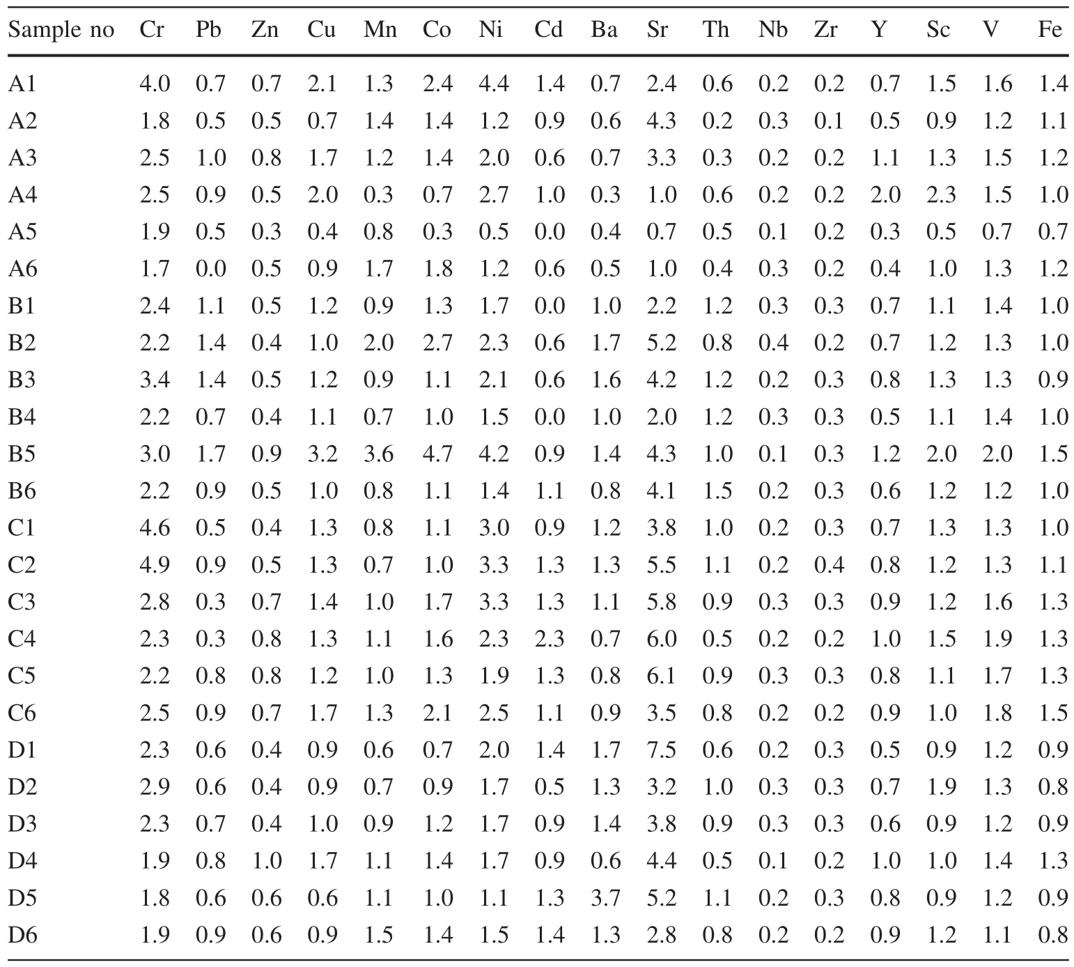
Table 5 Contamination index for metals in soils
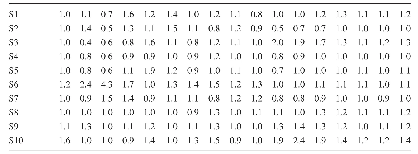
Table 6 Contamination index for metals in stream sediments Sample no Cr Pb Zn Cu Mn Co Ni Cd Ba Sr Th Nb Zr Y Sc V Fe
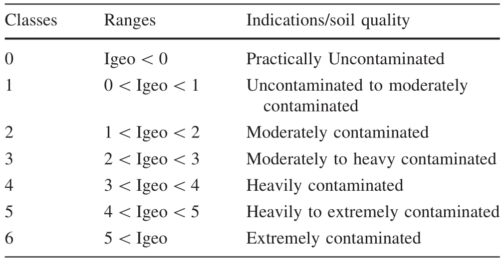
Table 7 Geo-accumulation index classes proposed by Muller(1981)
3.5 Statistical treatment of geochemical data
Statistical methods have been widely applied to interpret geochemical datasets and define geochemical associations.Such methods need to be used cautiously because of the particular characteristics of geochemical data which seldom represent a single population or distribution.The data are typically spatially dependent,and at each sample site a range of different processes have influenced the element abundances measured.Geochemical data are also imprecise due to unavoidable variability in sampling methods and media and the level of analytical precision;as a result,no single universally applicable statistical test has been developed for identifying anomalies.Therefore,a range of techniques is necessary to explore the nature of geochemical data before delineation of geochemical associations(Reimann and de Caritat 2005).Several elements were determined during geochemical exploration,and the concentrations and distributions were studied through maps,graphs,and statistics to identify anomalies in the environment.
Geochemical data sets are inherently multivariate,and multi-element analysis can determine the result of anthropogenic contamination if there are traces of it within the samples analyzed(Reimann and de Caritat 2005).A range of multivariate statistical methods can be used to assess the relationships within multi-element data sets.These methods commonly include Correlation matrices(using linear regression to test the correlation between pairs of elements)and Principal component analysis(useful for grouping elements into associations).
Correlation coefficients between 0.9 and 1 are deemed very high,Correlation coefficients between 0.7 and 0.9 are deemed high,between0.5and0.7are moderate,0.3–0.5low correlation,and<0.3 low correlation(Rollins on 1993).Correlation coefficients that are high indicate the occurrence of similar geochemical processes,factors,and reactions,which influence metal distribution(Li et al.2000,2001;Elueze et al.2001,2009;Zhai et al.2003,2008).The result obtained for correlation coefficients are presented in Tables 10 and 11).There are varying levels of correlation between the metals in the soil and stream sediments.Inter elemental relationship in the soils suggests different geochemical pathways are responsible for the metal content in both media.In the soil samples,a strong correlation exists between Mn–Co,Th–Zr,and Fe–V.This may indicate that elements have similar sources of input or are precipitated in the same media.Cr displays a high correlation with Ni and low concentration with other elements and negatively correlated with Zn,Mn,and Nb.Pb shows moderate correlation with Mn and Co and negatively with Cd and Sr.Zndisplaysa moderate correlation with Cu,Co,V,and Fe.Cu also shows moderate correlation with Mn,Co,Ni,Y,Sc,V,and Fe.Y and Sc show moderate correlation with Sc and V respectively.In stream sediments,a strong correlation that is close to unity exists between V and Y,Nb and Th,Zr,and Th;Fe also has a strong correlation with V,Y,Zr,and Nb at 0.01 confidence limit.Pb shows a high concentration of Zn,Cu,and Ni.Cd shows moderate correlation with other elementsbut shows a negative correlation with Ba and weakly correlated with Sr.Th shows high concentration with Nb,Zr,Y,Sc,V,and Fe.Cu shows positive and moderate correlation with Co and Ba while correlating negatively with other elements.
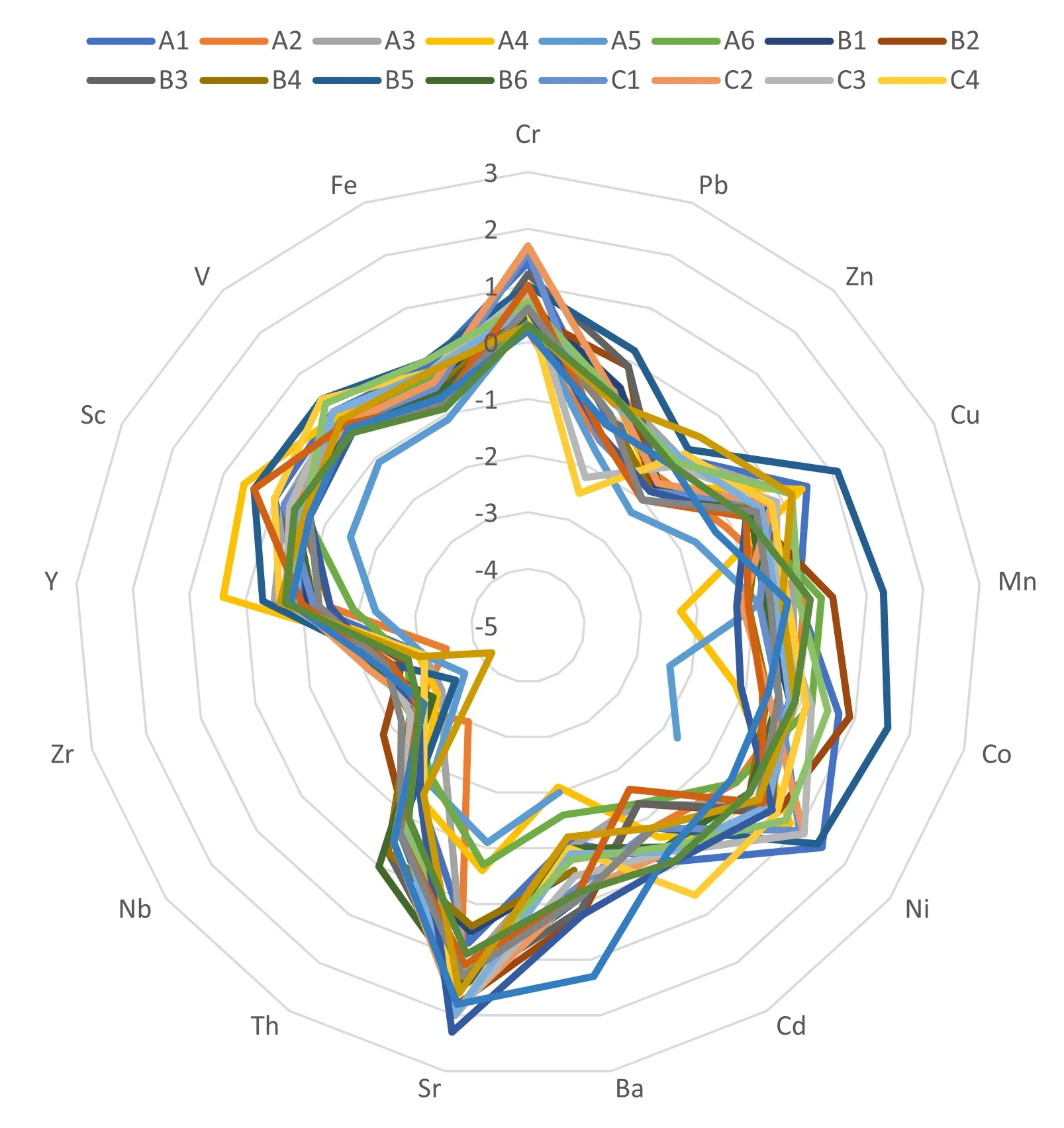
Fig.3 Geo-accumulation index(Igeo)of different metals in soils of the study area
The principal component analysis for soil revealed a five-component model as presented in Table 12 but the fifth component was not considered because of the values generated.The component factor one consisted of the following metals:Zn,Cu,Mn,Co,Ni,Y,Sc,V,Fe.It accounted for 33.68%of the variance.Zn,Co,Ni,V,and Fe are siderophilic(having a strong affinity for metallic phase and usually depleted in the silicate portion of the earth)and were well correlated with one another.The component factor two consists of the following metals Pb,Th,Zr and accounted for 16.08%of the total variance.Pb showed weak correlation with the other elements,so it can be inferred that they were anthropogenic influenced.In factor three,Sr accounted for 14.25%variance and Sr was poorly correlated with other elements.It may have been formed by adsorption of the metal by its oxide in the topsoil.Likewise,factor four contained Cr and Cd,accounting for 11.21%of the total variance.Although the statistical analysis may group them,they were anthropogenically introduced into the soil.This may be a result of weathering and erosion of rocks into the mining environment.Cd was poorly correlated with other elements.
The principal component analysis for stream sediments revealed a four-component model as shown in Table 13.Component factor one included Th,Nb,V,Fe,Y,and Zr.They accounted for 49.35%of the total variance.They showed high to moderate correlation with one another,and this indicates they were from the same source.Factor two contained Sc,Cr,Cd,and Mn.They accounted for 24.57%of the total variance.They were mostly chalcophile,and they had an affinity for sulphide phase,while factors three included Pb,Zn,and Ni.They accounted for 10.84%of the total variance,and the two elements showed weakcorrelation.They were of anthropogenic origin.However,factor four had Sr,accounted for 6.35%of the total variance,and Sr was poorly correlated with other elements but showed moderate correlation with Pb,Zn,and Ba.
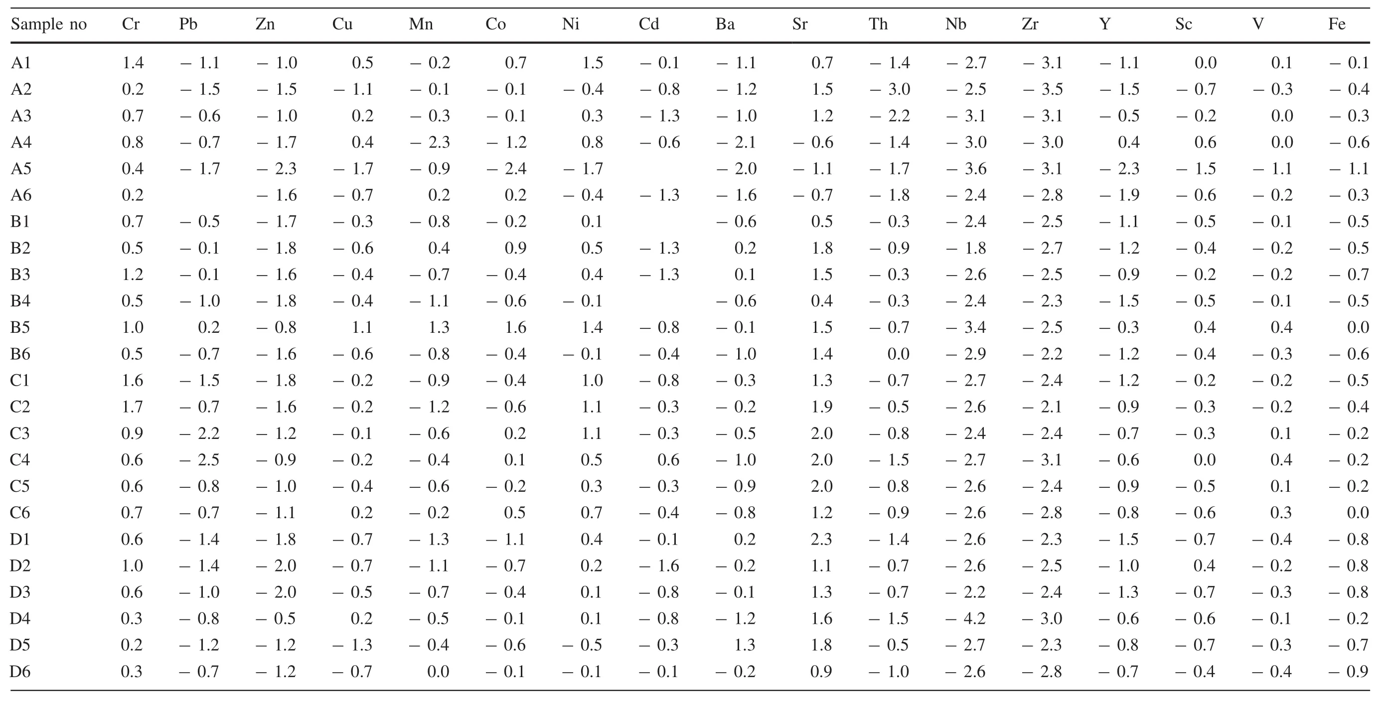
Table 8 Igeo index for metals in soils

Table 9 Igeo index for metals in stream sediments
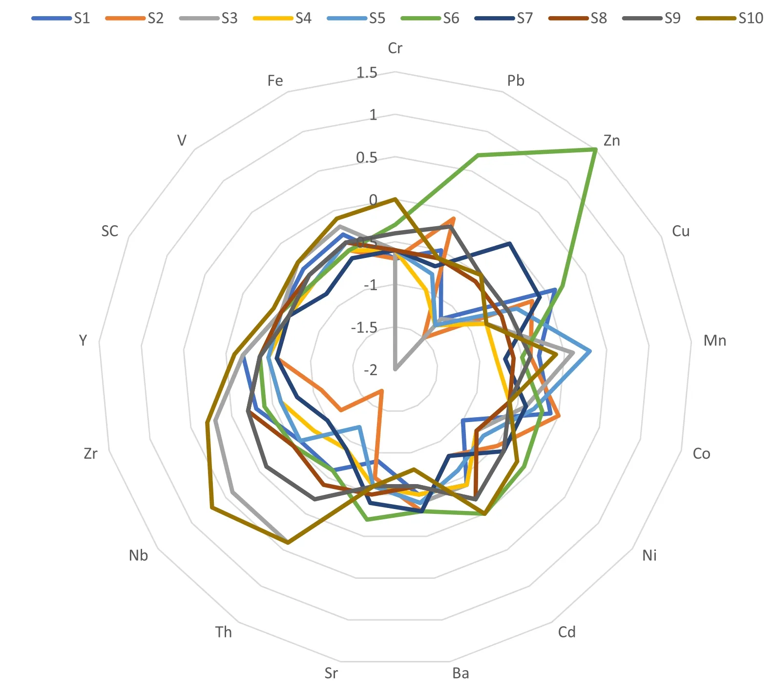
Fig.4 Geo-accumulation index(Igeo)of different metals in stream sediments of the study area
The results of the correlation coefficient and the PCA agreed well with the cluster analysis and hence helped to interpret the data.The linkage and clustering pattern of the trace elements in the two-media indicated four clusters(Fig.5a,b).The cluster analysis for the stream sediments showed that cluster one was made up of Th,Zr,and Nb,cluster two was made up of V,Fe,and Y,cluster three consisted of Sc,Cr,Cd,and Mn while cluster four was comprised of Pb,Zn,Sr,and Ni.Also,the cluster analysis for the soil samples in the sampling site also exhibited four clusters in this pattern;Mn and Co,Cu,Ni,Fe and Zn,Y,Sc,Pb,Cr,Cd,and Sr,Nb,Zr,Ba,and Th.This further confirmed the strong and existing relationship between the trace elements in the two media of the sampling sites as presented by both the factor analysis and the cluster analysis.
4 Conclusions and recommendations
The pH values for the soil were slightly acidic to slightly alkaline(6.10–7.19)while the stream sediments were neutral to slightly alkaline(7.0–7.8).Their EC and TDS values indicate its different distribution pattern from one sample point to another.Positive correlation coefficients were observed among some elements and grouped under similar factors using the factor analysis,indicating common sources of these trace elements in the soils and stream sediments from the study area.The study revealed that the soil is moderately contaminated with Cr,Ni,and Sr which may have been anthropogenically introduced into the soil.The variation plots of the concentration of elements in soils showed fairly consistent decrease away from the mining site in the East,West,and South while in the North,there was a random pattern.The stream sediments showed an elevated concentration of Zn when compared to the control background value and can be described as moderately contaminated.Plots of the trace elements in stream sediments samples showed moderate,consistent decrease upstream except at point 6–8 where there was mine water discharge into the main river.Geo-accumulation index(0<Igeo<1)and contamination index(CI<1.5)forsoils and stream sediment revealed uncontaminated to moderate contamination.The study has provided background information for a vulnerability assessment of the sampled area as well as for future impact assessment and proper planning of a mining site.Efforts should be made to curb the discharge of water from the mine into the river.Caution and restriction signs should be mounted around the mine environment to serve as a warning to people(strangers and cattle keepers)to prevent accidents.Finally,there is a need for implementation and enforcement of an environmental law,which may be a means of pollution control within mining districts.
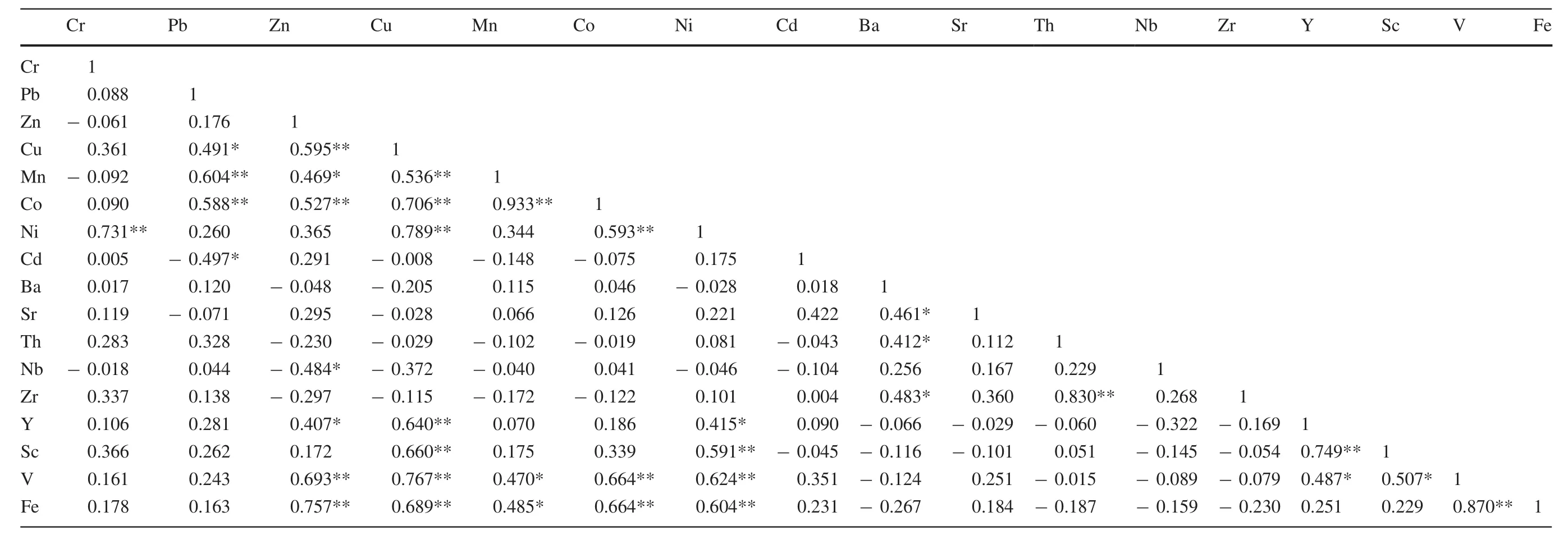
Table 10 Results of Pearson’s correlation matrix for soils in the study area
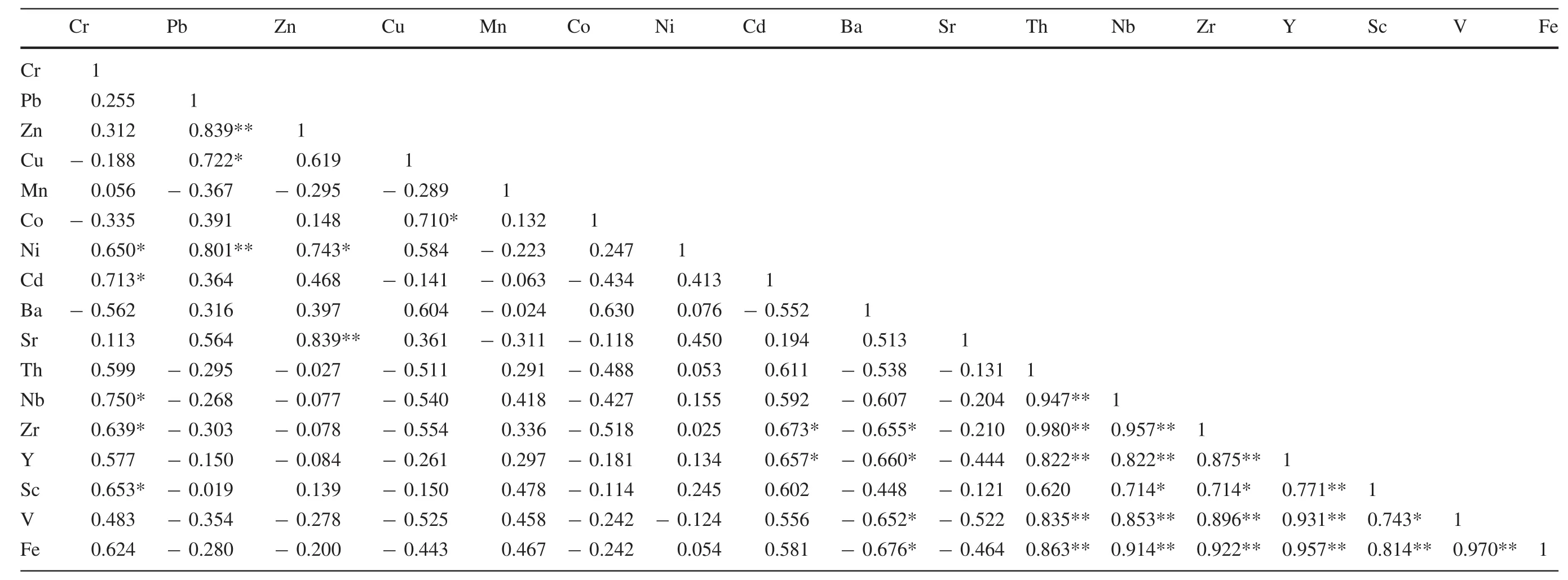
Table 11 Results of Pearson’s correlation matrix for stream sediments in the study area
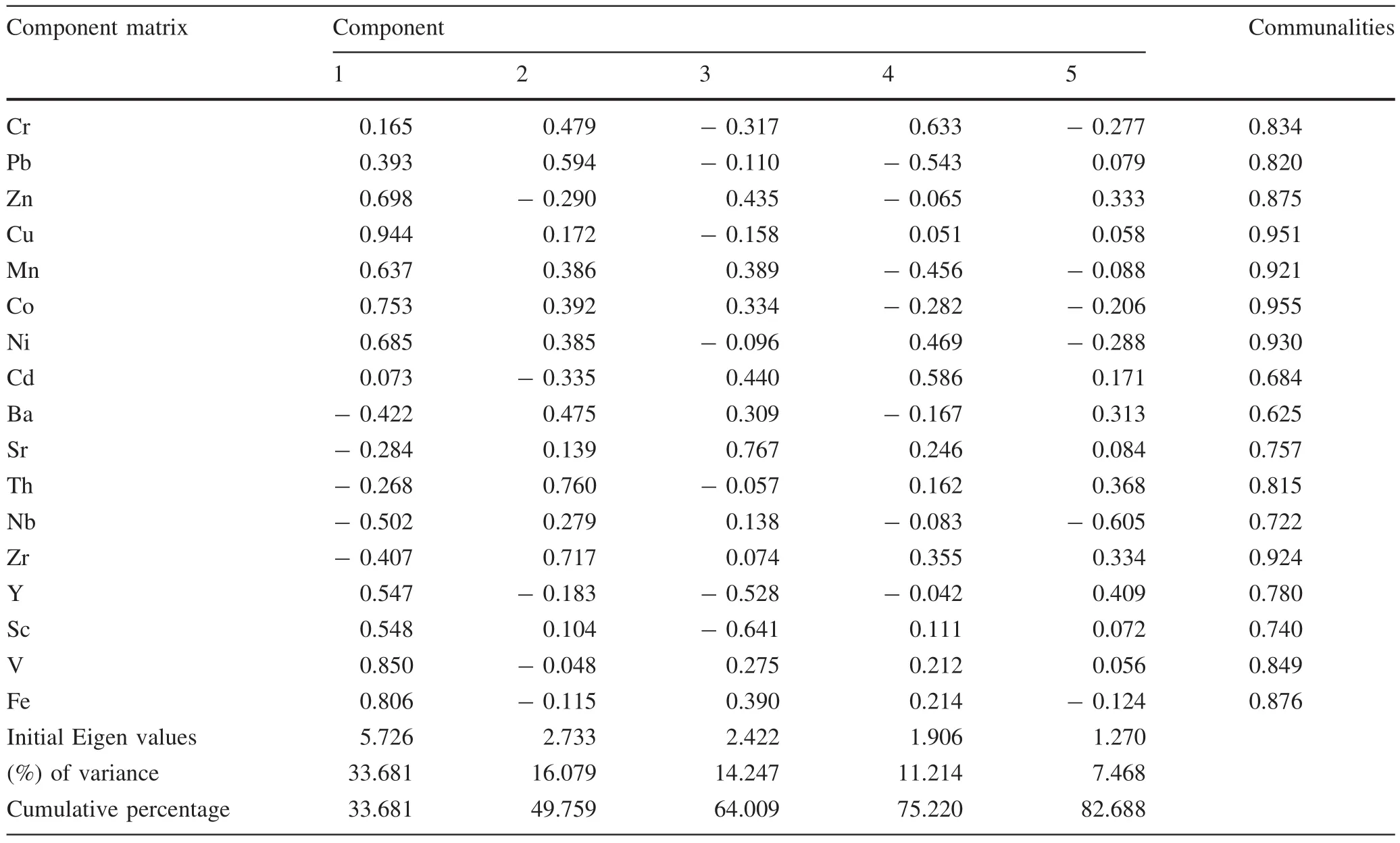
Table 12 The result of principal component analysis for soils in the study area
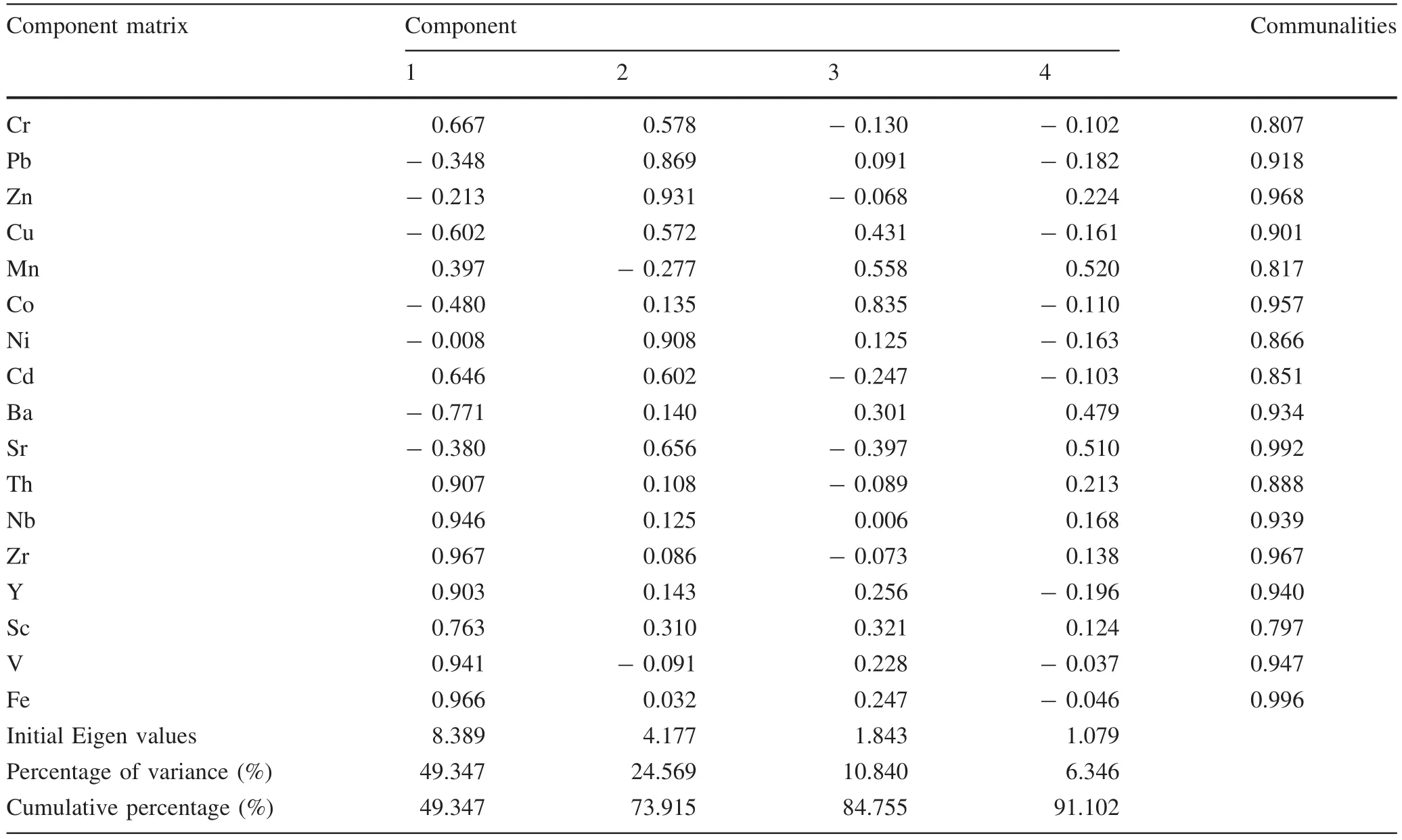
Table 13 The result of principal component analysis for stream sediments in the study area
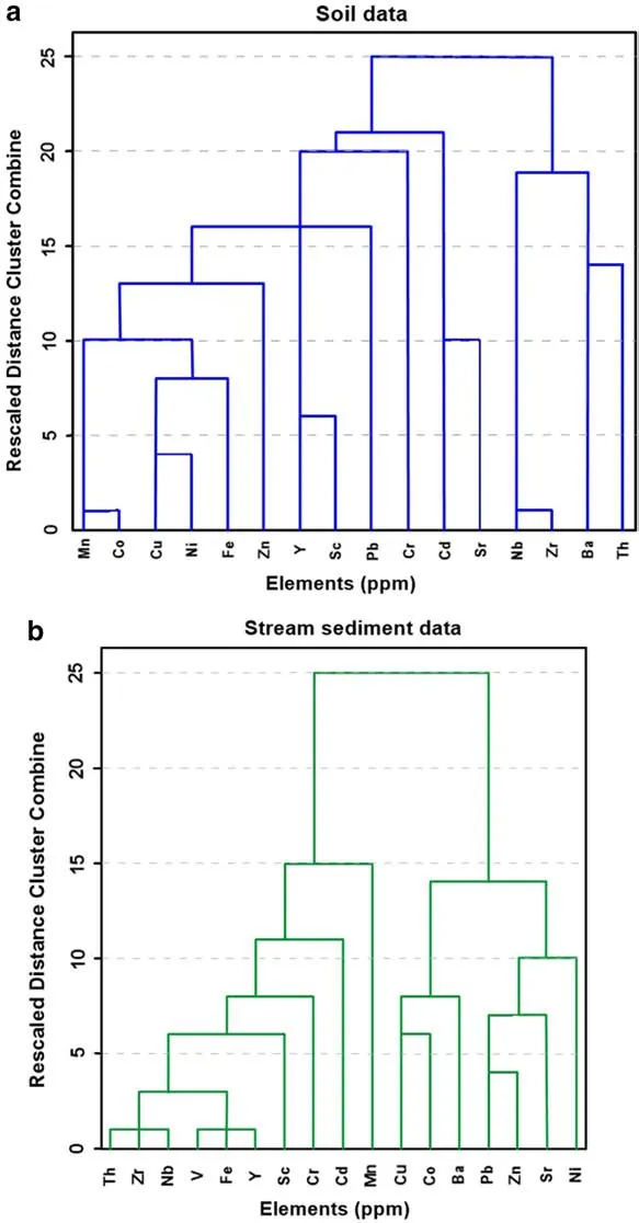
Fig.5 a,b Dendrogram using average linkage(between groups)for the analyzed data for soil and stream sediments and sample locations
AcknowledgementsThe first author is grateful to the Chinese Academy of Sciences and The World Academy of Sciences for sponsoring this research through the CAS-TWAS President’s Fellowship program.
Compliance with ethical standards
Conflict of interestAll authors declare that they have no conflict of interest.
杂志排行
Acta Geochimica的其它文章
- The vanadium isotopic composition of L ordinary chondrites
- Variations of tr ace elements under hydrological conditions in the Min River,Eastern Tibetan Plateau
- Effects of carbon anhydrase on utilization of bicarbonate in microalgae:a case study in Lake Hongfeng
- Enrichment characteristics and risk assessment of Hg in bird feathers from Caohai wetland in Guizhou Province,China
- Carbazoles and benzocarbazoles confirm migration of leaked petroleum through caprocks and overlaying formations of Valhall Well 2/8-8 in the North Sea
- Basic formation mechanisms of Lake Doroninskoye soda water,East Siberia,Russia
