空间句法的过去、现在和未来—凯文·林奇纪念演讲
2018-07-13比尔希利尔蒂姆斯通纳
比尔·希利尔(英) 蒂姆·斯通纳 (英)
秦潇雨 [译]杨 滔 [校]
“空间句法的核心是试图理解人的活动,然后为人们设计。如果我们关注那些超越智慧计算的事情,对我们产生真实的影响是繁荣的生活。”
—比尔·希利尔
比尔·希利尔非常荣幸被邀请参加今晚的凯文·林奇纪念演讲,而我也很荣幸宣读比尔·希利尔的演讲。首先,我无法在有限的时间内穷尽比尔才华的深度与广度。我对“天才”一词使用谨慎,而我和其他许多人都相信,他是一个天才(图1)。
我接下来的演讲可能会涉及一些概念,其中每个概念都值得深入解释和讨论,我也会提到在过去40年中比尔和空间句法帮助创造的数百个城市规划和建筑设计项目,但我希望我能描绘出比尔的个人成就。我想特别谈谈他所做工作的未来方向。未来很重要。比尔显然不是感性的,他更愿意谈论他目前正在工作的东西,或者是他还不甚了解的东西,而不是凝视过去。据我所知,他从不追求奖章。得之则幸,并不功利。而且我猜想,就像任何获得终身成就奖的人一样,他想知道为什么在他有生之年这么快就得奖了。我上周末与他谈话时,他解释说,他真正想谈论的是他目前正在研究的工作。但是,新兴理论通常如此,他还不确定他是否正确。换句话说,总是有更多的事情要做。
让我们以他的话作为开始,他说过:“我们如何设计城市正如我们如何理解城市。理解意味着通过某种思考模型(mental model),将构成城市的物理和空间模式与带给人们的体验和影响联系起来。这会涉及空间的思想,例如关于当地社区与整个城市之间的关系;也涉及功能性思想,例如关于活跃中心和次中心的选址方法和位置。无论来源如何,我们都可以将其视为一种“结构—功能”模型。它告诉我们,无论正误,如果我们用特定的方式来设计城市空间,它将改变城市的体验和运行方式。”
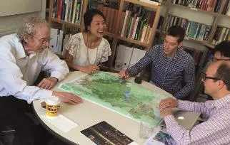
图1 / Figure 1比尔·希利尔 / Bill Hillier来源 / Source: Space Syntax
比尔·希利尔还说过:“凯文·林奇在科学的方向上对于这一模型问题进行了探讨,通过让人们描述他们所见的城市,揭示了5个空间和物理概念:道路(paths)、边界(edges)、区域(districts)、节点(nodes)和标志物(landmarks)。正如他所承认的,这些概念并非彼此独立。例如,边界通常是区域的边界,而节点是道路的交汇点。除了开发利用这些相互依存的关系,无人提出通用的原则来解释这些概念如何相互联系从而构造整个城市。”
“事实上,从整个城市的角度来看,城市意象中有一个妙趣横生的命题:‘道路,组成了城市综合体中最常见、最可能的活动线路网络,是城市整体赖以组织的最有效手段’[1]96。他补充说,与这个网络相比,‘边界、区域、节点和标志物’是‘其他元素的设计’[1]99。城市的形态以及5个元素的相互关联源于道路网络的结构。”
城市中道路网络的优先级与空间句法在将问题延伸至科学方向上的尝试,试图通过可观测功能而非人类的描述测度空间形式。空间句法理论认为,城市被理解为空间和功能系统的许多关键概念可以从街道网络的分析中推导出来。空间句法提出的“研究问题”是:是否有正式的方法来描述城市的空间结构,既能捕捉到其特有的空间形式,又能将它们描绘到可观测的功能模式上,并精确测度二者之间的联系。
事实证明,这一方法揭示了城市空间结构与其功能之间的基本关系:在其他条件都相同的情况下,构成城市的线呈现出的活动速率的关键因素即是空间结构本身,以及每条线与其他线之间如何关联。根据城市网络塑造活动的程度,我们称这种现象为自然活动的法则。它的普遍性成为许多结构现象的基础,而这些结构现象对于大多数城市而言都是共同的。通过这一基本法则,这一方法可以从科学的角度,从结构—功能模型引向城市的可测度结构—功能理论,从而帮助我们科学理解城市的经济和社会表现,并且可以用作城市设计的模型。
该方法产生了一系列值得铭记的概念,它们总结了城市的句法结构—功能理论,发展至今,可用以定义理论,正如林奇研究中产生的5个概念可用以定义城市一样。理解这些概念才能理解空间句法。空间句法中有如下5个核心概念。
第一,是空间本身的描述。可以将城市街道网络的混乱和复杂性打破为离散元素,然后将其作为计算分析的主题。在大多数空间句法分析中,离散元素是一条街道路口与下一个路口之间的道路中心线。它有一定长度,也有角度对准(从北到南,从西到东或之间的任何角度)。它的每一端都有许多连接,如果它是一个尽头路,它的一端可能连接为零, 另一端可能有两三个或更多连接。它有许多不同体量和用途的建筑物在侧。这些建筑物的数据可以游离于线,如同流于线上线下的服务数据一样。
第二,也是最重要的,正如比尔所解释的那样,自然运动理论表明,更多连接的街道能被更好地利用。连接度是使用计算机算法测量的,该算法测量人们从A到B移动时想要沿着单独街道移动的可能性。该算法计算所有可能的路线,不仅使用距离作为输入,还测度路线的复杂性。这是空间句法的独特卖点,大多数交通模型不包括其中的复杂性,因此,不能很好地描述真实的人类行为。那些可能会被利用得更好的街道会自动生成为红色,其次是橙色。较少使用的街道是绿色,然后是蓝色。数十年来,几千项研究已经证明了这一概念。对我而言,这是科学中最重要的发现之一。
第三个概念将城市描述为运动经济体。 换句话说,它解释了城市土地利用如何安排能够在自然运动模式中获利。 商店自然地移动到连接度更好的街道上,大多数房屋移动到小巷和后街上。
第四个概念,同步的多尺度城市为街道上的人类生活增加了基本的描述,这就是说,在任何街道上看到的活动都是人们在或长或短的距离上移动的组合。路线长短的比例可能会有所不同,但从某种程度上来说,这种比例往往与街道连接度的高低有关。
多尺度活动以及由此引发的人际互动对于交易至关重要,包括社会交易和经济交易。现代规划的一个缺点是过度分割了全球和地方活动。
第五,双重网络的概念提供了城市目的的定义。它允许我们区分主要路线的前景网络和次要路线的背景网络之间任何规模的活动。这是一个非常重要的概念,在此直接引用比尔的话:“城市空间的运行方式不止一种。前景网络的构建强化了活动,因为它是受微观经济因素驱动的,这些因素受益于高水平的活动。而背景网络限制和构造了活动,因为它是由社会和文化因素驱动的,其在住宅空间结构化方面得以体现。”因此,城市中的双重网络反映了功能和空间过程。
对于空间潜力的运作有两种途径。空间可以被有生产力地用于创造新的活动模式以及社会系统中的共存和潜在关系,亦可以被保守地表达和复制现有的社会模式和结构。前者与空间整合有关,后者与空间分离有关。前景网络和背景网络之间的差异是更形态成因的(morphogenetic)和更保守的(conservative)空间之间的差异。 前者关注活动创造的发展和变化,后者则弱化活动以保持其原有状态。
从某种意义上说,这种通用结构似乎成为了所有城市的基础,于是我们得出结论:在城市的个性化和文化类型之下,有一个通用的广普城市,它使城市成为它的本质。所有社会在某种意义上都必然是形态成因的,以应对不断变化的技术和社会环境,所有社会也必须以复制其结构的方式行事,因此空间被双重利用。城市是生产变化的庞大的空间形态制造机器,被设置为保守背景以稳定其结构,这即是广普城市(generic city)。我相信广普城市的发现使城市社会成为可能。
因此,空间句法方法的核心是一种愿望,旨在理解并设计出蓬勃生机的城市环境和稳定的社会环境。主要街道和城市中心的前景网络中已经产生了大量实践:社会和经济的互动、交易和创新。主要由住宅构造的街道安静地座落于背景网络中。如果我们能够超越聪明的计算,会意识到真正重要的是蓬勃生机。
然而,在诸多空间语法的呈现中,大量的技术分析有时会掩盖重要的文化信息,总是呈现出太多的图表以及太少的对于重要因果关系的基本陈述。我认为这对于一个年轻的学科而言是可以理解的,空间句法试图在怀有敌意的环境下找到自己的出路,面对每一个由建筑机构、内政部和交通规划师主导的转折点。在这种情况下,退出竞争抑或使用圈内行话要比使用大众通用语言容易得多。同样可以理解的是,在学术界,空间句法需要深奥严谨的科学辩论。然而,这门学科已不再处于青少年时代,而且城市的需求也不仅仅是学术。
空间句法如今已经成熟到需要发声。环境不再是怀有敌意的,讨论空间、连接度、场所、人民、步行以及积极的临街空间已经日趋普遍。20世纪80年代和90年代一去不返,在以汽车为中心的范式仍然占据主导地位的日益城市化的世界里,科学比以往任何时候都更需要理解全球城市化的变化步伐。
作为解释城市的为数不多的科学工作之一,空间句法有其特殊责任。空间句法已经参与了英国一些最为重要的项目,例如特拉法加广场的重新设计(图2)。在这个项目中我们解释了为什么旧的设计不起作用。首先进行观察,然后建立一个空间模型来说明人们为什么走在广场边缘,因为这些路线在空间上更为方便。这一诊断让比尔产生了一个创造性的想法:在广场中心建造一个新的阶梯。 我们的模型显示这将对行人流量产生重大的积极影响。 比尔与诺曼·福斯特(Norman Foster)分享了他的想法,从此便众所周知。
在我们合作过的所有建筑师中,诺曼·福斯特似乎最能理解空间句法:“我知道这些技术都是在艰苦的实践环境中创造的,我喜欢分析、观察、研究的工作,但也喜欢激情、不精确和直觉,空间句法是对这些对立世界相互作用的测试。”对于福斯特而言,空间句法并非是将先入为主的设计思想合理化的漂亮图谱,也并非愚弄外行的科技舞曲。相反,它是一种介于科学理性和艺术感性之间的设计工具。
我对此满怀信心,因为这是我自1992年加入比尔在伦敦大学学院咨询工作以来的亲眼所见。我们与诺曼·福斯特基金会合作开展了这个致力于提升伦敦自行车运力的项目,使伦敦每年增加了5亿次的自行车出行。我们并不愤世嫉俗地将它们从街道移除,而是增设通途(图3)。
在各项重大项目中,空间句法都毋庸置疑地被视作一种优化设计的工具。我们做了大量的幕后工作。比如为伦敦奥运会和残奥会创造伊丽莎白女王公园(Queen Elizabeth Park)(图4)。空间句法辅助了奥林匹克公园总体规划的设计,从而建立这些社区与西部和东部的联系。该公园至今仍是城市中的活跃地带(图5)。
在如今的伦敦,正如其他许多地方一样,空间句法的方法正在被潜移默化地用于各种各样的项目。在澳大利亚的达尔文,我们与市长和她的顾问团队一起工作,致力于制订一项规划,将城市中心的规模扩大一倍,从而创造出以街道为基础的、土地增值的新城市(图6)。城市总体规划通过设计工作室的方式开展工作。在工作进程中,空间句法模型被用于对新的想法进行“模拟测试”。最终的总体规划创造了与现有城市相结合的新的街道网络和空间网络(图7)。该规划使用空间句法模型进行了分析,以确保新的城市开发与一系列连接度较弱的街道建立强有力的联系(图8),通过这种方式建立了连接的等级结构,以适应不同土地用途的需求。繁忙的商业街和安静的住宅街道,以街道网络传统的连接方式相互隔离。前景网络和背景网络从理论延伸至设计实践(图9)。
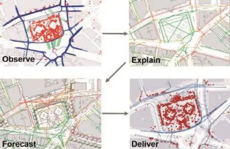
图2 / Figure 2伦敦特拉法加广场空间设计过程Spatial design process of Trafalgar Square, London
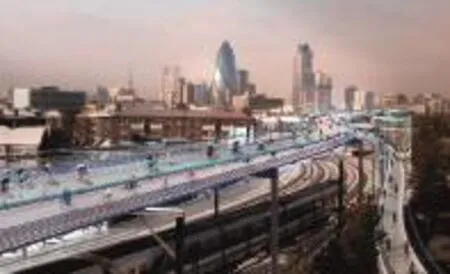
图3 / Figure 3SkyCycle影响城市可达性SkyCycle Impact on “urban accessibility”
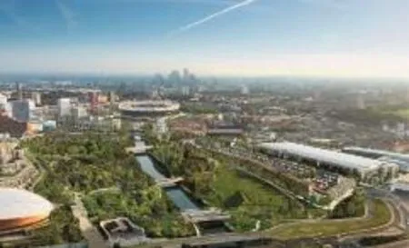
图4 / Figure 4伦敦伊丽莎白女王奥林匹克公园Queen Elizabeth Olympic Park, London
图5 / Figure 5伦敦2012概念性空间规划London 2012 Conceptual Spatial Masterplan
UrbanValue模型的构建使用空间句法分析作为关键输入(图10)。通过该模型确定土地增值至少可达37亿澳元。我们此前从未做过这样的模型。正如我们在特拉法加广场所做的那样,我们在那之前从来没有做过那么精细尺度的行人活动。 实践中的重要一课是它引发了研究。 如果得以有效地组织,工作室可以拥有像大学一般丰富的研究环境。传统学术界并非每个人都认同或者想认同这一点。但这是事实,这也是比尔与公司密切合作的原因之一。不是为了创收,是为了创造想法。
但这并不是说我们不与学术界密切合作,而是恰恰相反。例如,由伦敦大学学院发起的Urban Buzz项目大约十年前为我们提供了一个机会,比尔开展对入室盗窃问题的争议性研究,从而施展他对空间布局的重要性发现。这是一个复杂的研究,总而言之,连接度更好的街道(例如左边的街道)可以降低一个区域的财产成本,而连接较少的布局则会使之增加(图11)。
有了这些知识,我们就可以解决英国的住房建设挑战,设计与现状场所相结合的城市扩张方案。空间可达性模型提供了一个平台对方案进行测试。在这个规划中,空间句法帮助设计了一个创建双重网格的街道布局:一些以商铺为主的主要街道,以及一些用于非零售和住宅用途的连接度较差的其他等级街道(图12)。我们在主要街道上安排热闹的活动,并在小街上安排足够的活动以提供保证安全的“自然监视”。注意不要在无需活动的地方创造不想要的活动,比如这个安静的村庄。通过分析前后的对比,我们可以看出空间等级几乎没有改变,唯一真正的区别是有意地创造出了向北走出村庄的步行和自行车路线(图13)。
英国近期计划建设的一些由全国最优秀的设计师规划的新城,已经认识到其空间结构、土地使用状况以及由此产生的社会经济活动模式的局限性。在任何情况下,诊断都是相同的:前景网络和背景网络之间存在空间错位。不是历来持续连接的双重网络,而是完全不同的具有破坏性的网络。由于分割的城市肌理(将前景主街与背景住宅街道分隔开来的东西)不仅是以汽车为中心的高速公路网络,而且也是景观,因此更具挑战性。在某种程度上,绿地扼杀了人们的生活(图14)。
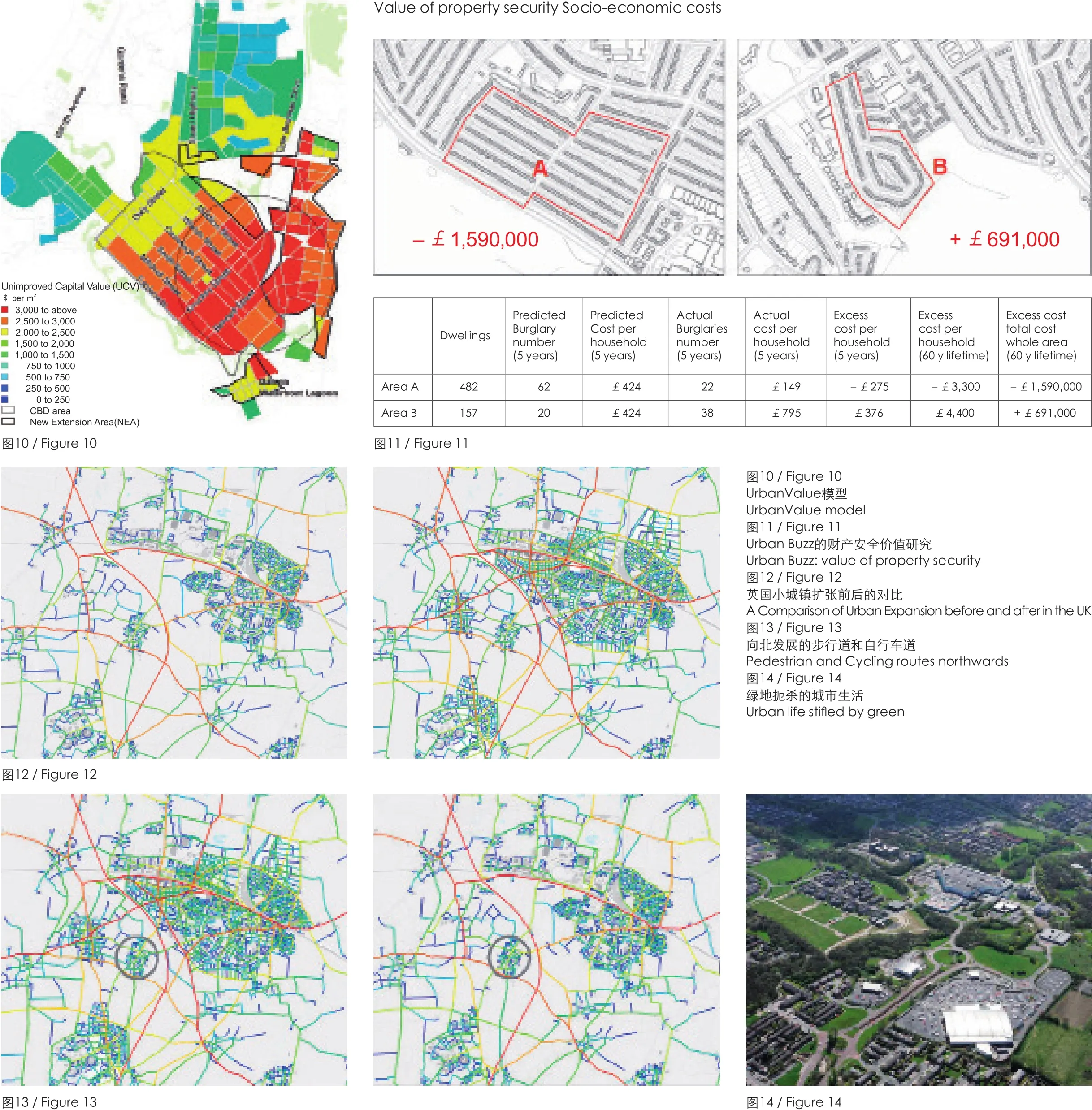
图15 / Figure 15间断开发造成的过度分散的城市The fragmented “city” of disconnected developments
我们最常见的一种空间状况是间断开发造成的过度分散的城市,或者说是间断的田园村庄造成的过于分散的走廊(图15)。历史呈现的是一种不同的模式:持续相连的社区构造出完整的城市(图16)。你可以从一个中心到另一个中心之间行走,而当你从一个社区走向另一个社区时,却从未意识到这一点。
社区的边缘不是由高速公路或过度宽阔的景观带划定的,而是由比尔所谓的住宅街道的“模糊边界”(fuzzy boundary)划定的,比如绿色的街道、树木、树篱和边缘,如此种种,但是街道本质上是一样的。这并非是对于环境的妥协,而是恰恰相反。生态学家告诉我们,由持续连接的绿色街道构成的城市在生态上比乡村更加多样化。所以我们需要大大小小的街道、绿色的街道、持续连接的街道网络以及偶尔出现的特别的公园和开放空间,而不是拼布一般拼凑而成的伪造城市或不相连的村庄系统。
城市设计的关键因素仍然是连续不断的街道网络。除了如上所述的支持规划和设计过程的传统用法,空间句法正在以多种创新方式被广泛使用。例如,我们使用空间布局模型来推测伦敦防洪的失败如何影响城市的大规模移动模式(图17)。我想我们都本能地认为,伦敦市中心的桥梁连接损失会破坏通信。 但究竟如何?新的路网等级结构会是怎样?
图16 / Figure 16持续相连的社区构造出完整的城市The integrated city of continuously connected neighbourhoods
空间可达性模型使我们首先能够确定人们可能集中的状况以及他们日常的主要移动轨迹。
由此产生了自相关,事实证明,空间分析本身就是整个人类密度和活动的有力预测指标。然后,我们可以移除水灾引发的那些连接。而后如你所见,伦敦的运动模式完全被改变(图18)。
这种分析可以用于应急措施和疏散控制。从长远来看,它可以帮助确定活动走廊的修复和重新开放的优先顺序。我们可以通过加载各地的精确土地利用组合、建筑物密度以及交通路线的位置和容量(公交车、地铁和火车)来进行更加复杂的分析。但是,首先了解单独的空间如何利用非常重要。毕竟,水灾来去,唯有空间永存。
类似的原则适用于任何重大的城市事件和事后疏散,正如2011年发生在新西兰克赖斯特彻奇(Christchurch)的事件一样。克赖斯特彻奇是一座建构在历史悠久的网络上的城市。从红色代表的高度可达的路线中可以看到,它扩散了南北、东西之间的城市运动。这些线路集中在城市的最中心,支持着克赖斯特彻奇的零售和商业中心,这是该地区最为集中的商业地产。地震摧毁了这个中心,导致中心商务区关闭约4年。克赖斯特彻奇不得不迅速适应并承受灾难性的经济危机。
图17 / Figure 17伦敦水灾地图,2008London fl ood map, 2008
有两件事值得一提。首先,城市的连续网络布局是城市生存的关键,它提供了路线选择,以便城市活动能够立即适应道路封闭。 相比之下,将交通逐渐集中到主要公路上的城市,当其中一条路崩溃的时候,整个交通系统可能会随之崩溃。其次,新的中心如斯坦莫尔路(Stanmore Road)的出现,既是新生的也是商业在既有的外围中心再生的体现。建模可以帮助城市规划其长期恢复及短期疏散和救援工作(图19)。
有些事件是短暂的,并且可能在当时显得随机而混乱,例如2011年的伦敦暴乱事件(图20)。我们研究了事件的时间、地点及发展态势,利用媒体数据来绘制暴乱的事例。然后,我们在这些地理位置上展开分析。首先,我们可以看到84%的事件发生在多重剥夺指数(Index of Multiple Deprivation,简称IMD)高于平均水平的地区。这只是一个开始,但是并不能解释为什么有些IMD评分高的地区出现了更严重的暴乱,而有些则完全没有出现暴乱。放大并以更精细的方式查看,我们发现大多数事件发生在更可达的街道上(图21)。这是有帮助的,但这些街道是商铺所在的地方,不是吗?而为什么一些主要街道没有发生暴乱?我们增加一个层次来解释,就会更清晰地呈现出结果(图22)。
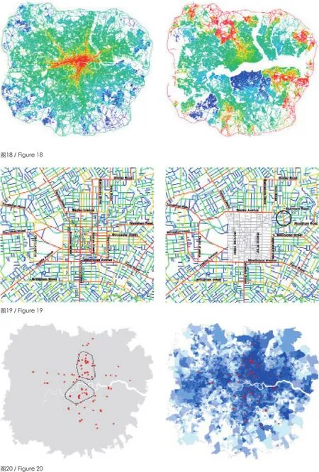
图18 / Figure 18伦敦水灾的前后对比Flooding London, before & after图19 / Figure 19克赖斯特彻奇地震和城市复苏前后对比Earthquake & urban recovery in Christchurch, before & after图20 / Figure 202011年伦敦暴乱London Riots 2011
我所展示的所有工作(水灾、地震、暴乱等工作)都是作为内部研究完成的。基于空间句法,我们花费了大量的时间来进行无偿的内部研究,开发软件、研究方法并开发适用于业界的应用。城市设计并非锦上添花,而是防患于未然。
此外,空间句法的工作越来越多地涉及到建筑物内部的人的运动和行为,空间分析软件已被开发用于理解及预测人们在精细尺度上的行为,比如在零售环境中、在办公室以及博物馆和画廊中。这里以英国泰特美术馆为例(图23)。左图为100个人在10分钟内创建的实际运动轨迹(我们通过跟随他们来得出运动轨迹)。右图为仅基于建筑平面图的空间可达性分析图,并再次展示了空间在塑造人类活动和相遇中的重要作用。
我试着总结一下我们在空间句法方面的所作所为(图24)。我们已经建立了一个旨在创造和培育蓬勃生机的组织。然而,我们的客户和合作伙伴与我们非常接近,这个理念与他们的利益相吻合。我们将这个想法融入具有两个关键特征的工作程序中:基于科学、以人为本。当我问比尔是否可以用一句话来描述空间句法时,他将其简化为2个词:基于科学、以人为本(science-based and human-focused)。
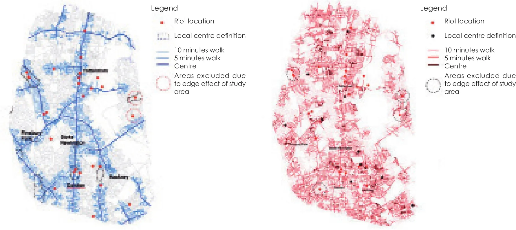
图21(左) / Figure 21 (left)大部分事件发生在更为可达的地方Most incidents occurred in more accessible streets图22(右) / Figure 22 (right)所有单一事件都出现在当地商业街或封闭下区800m以内的范围内every single incident occurred within 800 m of both a high street and an estate
我们主要从事3种工作:第一,在实践中应用这种方法;第二,持续迭代,与时俱进:新的数据来源,新的计算能力以及来自客户和合作伙伴的新问题;第三,广为传播,这可能是三者中最为重要的。
我们通过咨询和工作室的方式应用空间句法,从而运营公司。空间句法公司支持设计师创建并测试设计方案。例如最近在伦敦金融城开设的彭博新总部(图25),该总部在惠特灵大道(Watling Street)的古老街区中整合出一条街道(图26)。
再造这条街的想法已经酝酿了大约20年了。它来自对周围街道网络的分析。就像特拉法加广场的阶梯一样,这个想法跃然纸上,但是,在此之前无人绘制。空间建模帮助说服决策者这是一个值得拥有的想法。除了与个体开发商合作外,空间句法还为整个伦敦金融城构建了一个行人运动模型(Pedestrian Movement Model)。在几年之内,我希望任何重要的经济中心都能拥有它。
除了咨询部门以外,空间句法工作室还为公共部门和私营部门的客户做设计准备工作,担任多学科团队的首席设计师。这是空间句法的一个重要发展。我们通过另外两项活动来开发空间句法的方法。第一是研究实验室(research Laboratory),研究如前所述的关于水灾、地震等问题的工作。第二是数字工作营(DigitalWorks)开发技术,我们尝试将其运用在研究项目以及咨询和工作室工作中。
研究实验室和数字工作营目前正在参与我们与Future Cities Catapult合作开展的工作,致力于创建一个新的开源技术来连接数据集。为此,我们正在积极寻找健康不平等的现象。例如,包括与汽车依赖相关的孤独现象,而汽车依赖现象直接受到空间规划的影响。 我们联合了健康、交通和城市设计领域,以了解传统上并不相关的数据集之间的关联。
这对专业实践具有重要意义,并且我们相信,城市设计专业必须具有一种破坏性的潜力。城市设计师的决定对人们的生活产生着深远的影响。越来越多可用的数据集以及我们进行数据分析的计算能力,意味着只要我们掌握了着眼点和方法论,我们将超越古今。
例如,图中显示了城市形态、汽车依赖及其如何影响人们的求职能力(图27)。通过展示传统交通规划实践如何固化不平等,阻碍了社会和经济的流动,提出我们作为城市设计师可以为关于场所的讨论做出强有力的、有据可依的贡献。我们可以解释连接何以如此重要,多少连接度是足够的,即使太多也是有害的。我们为可步行性提供论据,论证这是城市设计所必须具备的(图28)。
我们可以参与关于医疗保健供给的讨论。首先就其位置而言,其次就其质量而言,通过可视化和感官分析,我们可以帮助患者发声。 我们将他们关联到空间中,将空间维度引入更为丰富的对话中,将空间分析嵌入政策辩论,将难以理解的社会和经济现象进行空间化(图29)。
我们并不自认为拥有所有答案,但是我们有一种可以帮助剖析复杂问题的方法,我们一直在寻找更多的挑战。但空间句法不能单独完成这一切,我们也不想如此。我们只想为我们所创造的一切提供广泛的实践—我们的理论,我们的软件,我们的方法,我们的数据。
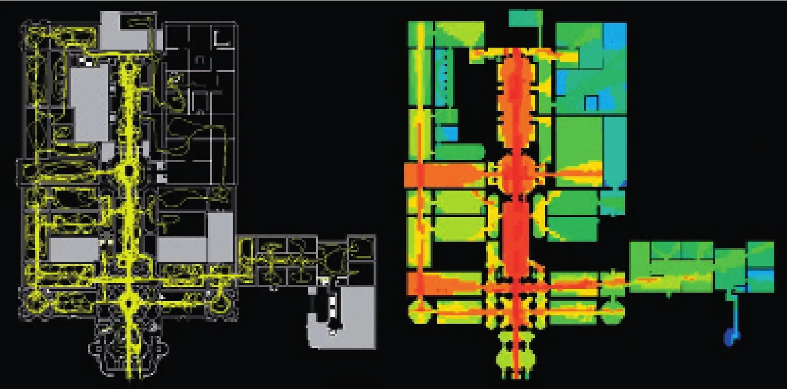
图23 / Figure 23泰特美术馆空间分析Spatial analysis of Old Tate Britain
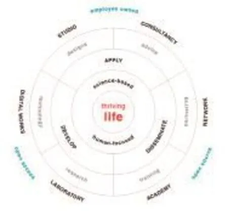
图25(右) / Figure 25 (right)彭博总部,伦敦城Bloomberg Headquarters, city of London
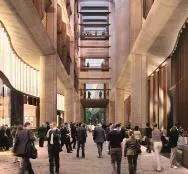
图24(左) / Figure 24 (left)我们在空间句法所做的事情A summary of what we’re doing at Space Syntax
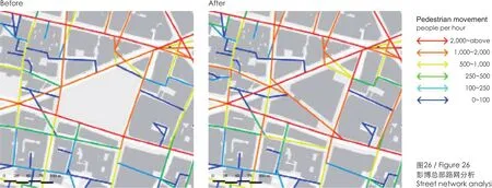
图26 / Figure 26彭博总部路网分析Street network analysis ofBloomberg Headquarters
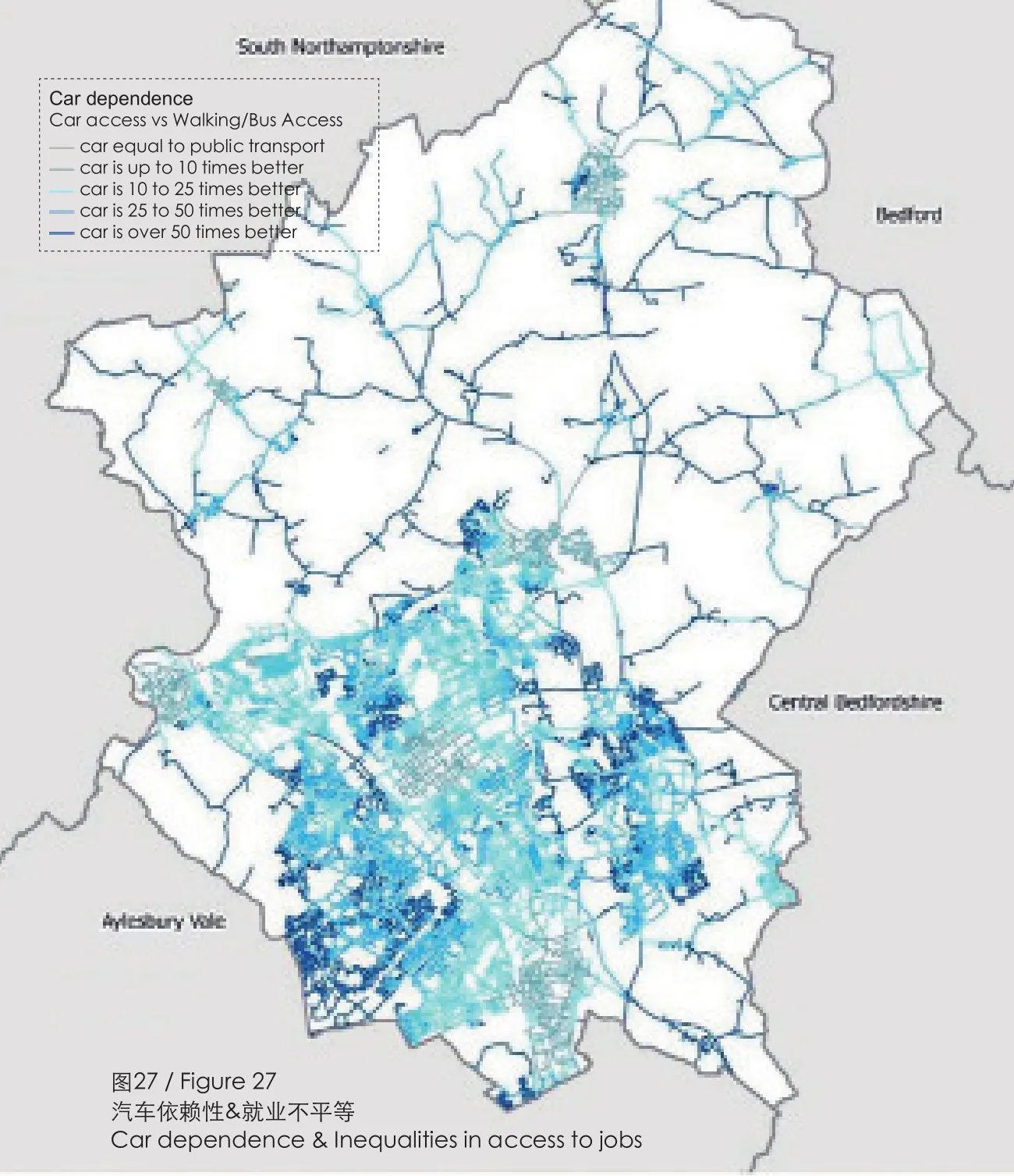
图27 / Figure 27汽车依赖性&就业不平等Car dependence & Inequalities in access to jobs
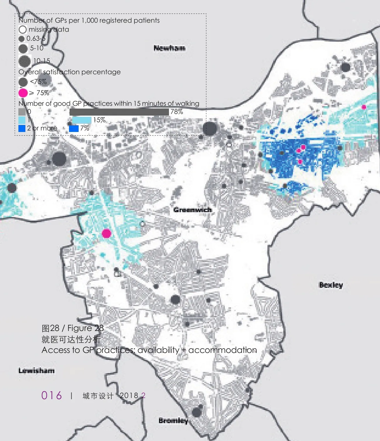
图28 / Figure 28就医可达性分析Access to GP practices: availability + accommodation
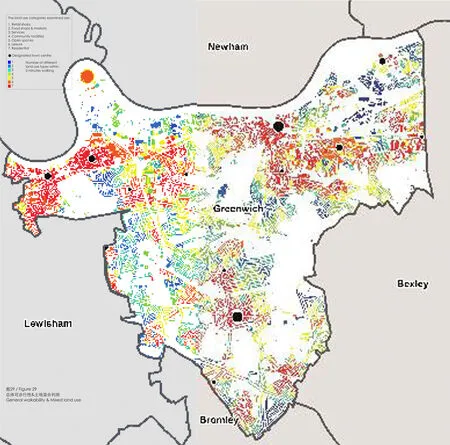
图29 / Figure 29总体可步行性&土地混合利用General walkability & Mixed land use
Space Syntax Past, Present & Future:Kevin Lynch Memorial Lecture
Bill Hillier, Tim Stonor
“At the heart of the Space Syntax approach is a desire to understand, and then design for, people.If we look beyond the clever computation, what it matters is thriving life.”
Bill Hillier
It’s a great honour to have been asked to give this evening’s Kevin Lynch Memorial Lecture, and a special honour to be doing so on behalf of Bill Hillier.
First, I can’t do justice in the time available to the breadth and depth of Bill’s genius. And I use the word genius carefully. I believe, as do many others, that he is a genius (Figure 1). I may only this evening touch on concepts that each deserves a more lengthy explanation and discussion. And,likewise, on the hundreds of urban planning and building design projects that Bill and Space Syntax have helped create over the past four decades.
I want to talk especially about the future directions that his work is taking. The future is important because Bill is not obviously sentimental. He is far more likely to want to talk about something he is currently working on, or something he doesn’t yet understand, than to dwell on the past. He hasn’t ever, to my knowledge, sought prizes. He’s enjoyed them when they’ve appeared, but he hasn’t gone after them.
And, I suspect like anyone receiving a Lifetime Achievement Award, he has wondered why it was being given so soon, before his lifetime is fully achieved. When I spoke with him last weekend he explained that what he’d really like to be talking about is what he’s currently working on. However,as is often the case with emerging theory, he’s not sure he’s right about it yet. In other words there’s always more to be done.
So let’s begin with some words from him. He says, “How we design cities is how we understand them. By understanding, we mean having some kinds of mental model linking the physical and spatial patterns that make up the city to how they are experienced by people and how they work for them.
This may involve spatial ideas, for example about the relation between local neighbourhoods and the city as a whole, and functional ideas, for example about how and where active centres and sub-centres can be located. Whatever its source, we can think of this as a “structure-function” model. It will tell us,rightly or wrongly, that if we design the space of the city in this way rather than that, it will change how the city is experienced and works.”
Bill goes on to say: “Kevin Lynch took the question of such a model in the direction of science by bringing to light fi ve spatial and physical concepts through which people described the cities they saw:paths, edges, districts, nodes and landmarks. As he acknowledged, these are not independent of each other, for example edges will normally be the edges of districts, and nodes the meeting of paths. Nor are there argued to be general principles of how the concepts relate to each other to form the city as a whole, other than to exploit these interdependencies.”
“In fact, from the point of view of the city as a whole, there is a remarkably interesting proposition in the Image of the City: ‘The paths, the network of habitual or potential lines of movement through the urban complex, are the most potent means by which the whole can be ordered’[1]96. Compared with this network, he adds, the ‘edges, districts, nodes and landmarks’ are the ‘design of other elements’[1]99.The form of the city, and the interrelating of the fi ve elements, arises from how the network of paths is structured.”
The priority of the path network in cities is shared by Space Syntax in its attempt to take the question further in the direction of science, by testing spatial forms against observable functions rather than human descriptions. Space Syntax argues that many of the key concepts for understanding the city as a spatial and functional system can be derived from the analysis of the street network. The “research question” posed by Space Syntax is: Is there is a formal procedure to describe the spatial structure of the city which both captures its characteristic spatial forms, and maps these onto observable functional patterns with enough rigor to test the link between the two?That this turns out to be the case which due to the fact that the procedure brings to light a fundamental relation between the spatial structure of the city and its functioning: that other thing being equal the key determinant of movement rates in the lines that make up the city is the spatial con fi guration itself,how each line relates to all the others. We call this phenomenon—of the degree to which movement is shaped by the urban grid—the law of natural movement. Its generality underlies many structural phenomena which are common to most, if not all,cities.
Through this fundamental law, the procedure can,in scientific terms, lead from a structure-function model to a testable structure-function theory of the city, one which could serve both our increasing need for scienti fi c understanding of the city in terms of its economic and social performance, and as a model for use in design. The procedure generates a set of memorable concepts which summarise the syntactic structure-function theory of the city as far as it has been so far developed, and can be used to define the theory, as Lynch’s five concepts define the view of the city that emerged from his research.“Understand these concepts and you understand Space Syntax.”
First, is the description of space itself. That it’s possible to break the apparent chaos and complexity of a city’s street network into discrete elements that can then be the subject of computational analysis.In most Space Syntax analysis, the discrete element is the road centre line between one street intersection and the next. This has a length. It has an angular alignment (north to south, west to east or any angle in between); it has a number of connections at each end of it. At one end it may have 0 if it’s a cul de sac. At the other it may have just two or three or more. It has a number of buildings along it, of dierent sizes and uses. Data on these buildings can be hung othe line. As can data on the services that fl ow above or below the line.
Second, and most importantly, is the theory of natural movement, which as Bill just explained,demonstrates that the more connected streets are better used. Connectivity is measured using a computer algorithm that measures how likely it is that people will want to fl ow down individual streets as they move from A to B. The algorithm calculates all possible journeys using not only the distance as an input but also the complexity of the journey. This
is the USP of Space Syntax - most traffic models don’t include complexity in them, and as a result,don’t work particularly well to describe real human behaviours. Streets that are likely to be well used are automatically coloured red, then orange.Less well used streets are coloured green then blue. The concept has been demonstrated now in thousands of studies over several decades. To me it’s one of the most important discoveries in science.
The third concept describes cities as movement economies. In other words, it explains how land uses in the city arrange themselves to take advantage of the natural movement pattern. The shops move to the more connected streets with more natural movement. The houses move, in the majority, to the side and back streets.
The fourth concept of the simultaneously multi-scale city adds a fundamental description of human life in streets, which is that the activity you see on any street is typically a mix of people moving across longer and shorter distances. The proportion of longer to shorter journeys may vary from the more connected to the less connected streets but it is always, to a degree, there. Multi-scale movement, and the human interactions that are induced by this, are fundamental to trade. To both social and economic transaction. One of the shortcomings of modern planning has been to overly separate global and local movement.
Fifth, and fi nally, the concept of the dual grid provides a de fi nition of the purpose of cities. It allows us to distinguish, for any scale of movement,between the foreground grid of main routes and the background grid of minor routes. This is so important a concept that I’m going to quote Bill directly again:
“Finally, (he says) space in cities works in more than one way. The foreground network is structured to maximise movement, and it is so because it is driven by micro-economic factors which benefit from high levels of movement, while the background network restricts and structures movement,and does so because it is driven by social and cultural factors which fi nd expression in the way residential space is structured.” So the dual network in cities re fl ects functional as well as spatial processes.This is an instance of the more general potential of space to operate in two ways. Space can be used generatively to create new patterns of movement and so co-presence and potential relations in the social system, or it can be used conservatively to express and so reproduce existing social patterns and structures. The former is associated with spatial integration, the latter with spatial segregation.
The difference between the foreground and background networks is the difference between more morphogenetic and more conservative space. The former focuses movement to create development and change, the latter diuses it to keep things as they are. This generic structure seems to underlie all cities in some sense, and we must conclude that beneath the individuality and cultural typing of cities, there is a universal generic city which makes the city what it essentially is. All societies must in some sense be morphogenetic in order to cope with changing technological and social circumstances,and all societies must also act in ways that reproduce their structures, hence the dual use of space.
Cities are spatially massive morphogenetic machines that produce change, set into a conservative background which stabilises their structure.This is the generic city. It was I believe the discovery of the generic city that first made urban societies possible.” At the heart of the Space Syntax approach therefore is a desire to understand and then design for both thriving life and societal stability. Plenty of actions on the foreground grid of main streets and in the centres: social and economic interaction, transaction and innovation. Quiet repose in the background grid of mainly residential streets. If we can look beyond the clever computation, what matters is thriving life.
However, in many Space Syntax presentations, a wash of technical analysis has sometimes obscured the key cultural messages; too many graphs and too few statements of fundamental “so therefore”importance. Now I think this is forgiveable in a young discipline trying to fi nd its way in a hostile context—confronted at every turn by the architectural establishment, by the Home Office, by the transport planners.
It’s far easier in such circumstances to withdraw and to talk the secret language of the clique than the common language of the crowd. And it’s also understandable that, in academic circles, Space Syntax needs the esoteric rigour of scienti fi c debate.But the discipline is no longer in its teenage years and the needs of cities are more than academic.
Space Syntax is mature now, and needs, I believe,to have its voice. The context is no longer hostile—to the discussion of space, connectivity, place,people, walking, active frontages. The 1980s and the 1990s are no more—and in an increasingly urbanising world in which car-centric paradigms still dominate, science is needed, more than ever, to make sense of the pace of change in global urbanism.
As one of the few scienti fi c eorts to explain cities,Space Syntax has a special responsibility. Space Syntax has been involved in some of the most important projects in the UK, such as the redesign of Trafalgar Square (Figure 2). We explained why the old design didn’t work—first through observations, then through the construction of a spatial model that showed why people walked around the edges of the square because the routes were more spatially convenient.
Of all the architects we’ve worked with, Norman Foster seems to understand Space Syntax best: “I know that these techniques work from the tough environment of practice. I love the work of analysis, observation, of research but also passion,imprecision, the hunch. Space Syntax is the testing of the interaction of these opposing worlds.” To Foster, Space Syntax is not a set of pretty—if complicated—pictures to post-rationalise preconceived design ideas: a techno-wash to bamboozle the uninitiated. Instead, it’s a design tool that mediates between rational science and artistic emotion.
I can say this with con fi dence because I’ve seen it fi rst hand since joining Bill’s consultancy work at UCL in 1992. And currently, working with the Norman Foster Foundation on this project to expand London’s cycling capacity with another 500 million cycle journeys a year. Not to remove it from street level—as was cynically assumed—but to add to it(Figure 3).
Space Syntax was conceived as a tool to facilitate design. To take the guesswork out of it. What we’ve done has been behind the scenes...as in the creation of the Queen Elizabeth Park for the London Olympic and Paralympic Games (Figure 4). Space Syntax helped to shape the design for the Olympic Park masterplan so that it made connections with those communities to the west and east. This means that the park remains an active part of the city today(Figure 5).
In London today, as in many other places, the Space Syntax approach is being quietly used on a wide range of projects. And sometimes more prominently, such as here in Darwin, Australia, where we worked with the Lord Mayor and her team of advisors, to create a plan that doubles the size of the city centre in a way that will create new, street-based urbanism with enhanced land values (Figure 6).
A masterplan was developed for the city through a process of design workshops. During these workshops, a Space Syntax model was run to “live test”emerging ideas. A final masterplan was produced,creating a new network of streets and spaces that integrates with the existing city (Figure 7). This plan has been analysed using the Space Syntax model to make sure that strong connections were made into, and through, the new developments and that a set of quieter, less well connected streets was created (Figure 8). In this way a hierarchy of connections was produced to accommodate the movement needs of dierent land uses: busier commercial streets and quieter residential streets, only a turn away from each other in the manner of traditionally connected street grids. The foreground grid and the background grid make it from theory into design practice (Figure 9).
An UrbanValue model was constructed, using Space Syntax analysis as a key input (Figure 10).This model identified land value increases of at least 3.7 billion Australian dollars. We’d never quite produced a model quite like this before. Just as we’d never quite produced a fine-scale pedestrian movement before as we did for Trafalgar Square.One key lesson from practice is that it provokes research. If you organise it correctly, the studio can be as fertile a research environment as the university.
Not everyone in traditional academia agrees with this—or wants to agree. But it’s true and it’s one of the reasons that Bill engages so closely with the company. It’s not to make money. It’s to make ideas. But that’s not to say we don’t work closely with academia. Far from it. For example, the UCL-led Urban Buzz project gave us an opportunity around ten years ago to develop Bill’s controversial research into burglary. To fi nesse his fi ndings about the importance of spatial layout.
It’s a complex explanation—not for today’s presentation - but, in summary, better connected streets,such as those on the left, can reduce the lifetime costs of an area whereas less connected layouts can increase them (Figure 11). Armed with this knowledge we can address the UK’s housebuilding challenge, designing urban extensions that integrate with existing places.
Spatial accessibility modelling provides an evidence platform to test proposals on. In this plan,Space Syntax has helped to design a street layout that creates a dual grid: a few main streets for the shops and a hierarchy of medium to less well connected other streets for non-retail and residential uses (Figure 12).
High movement on the main streets where we want it and sufficient movement on the side streets to provide “natural surveillance” that facilitates safety.And being careful not to create unwanted movement through places where it isn’t wanted such as this quiet village. By toggling between before and after analyses we can see that the spatial hierarchy is barely altered—the only real dierence being the creation—deliberately—of a walking and cycling route northwards out of the village (Figure 13).
Closer to home a number of recently planned New Towns – planned by the nation’s fi nest—have recognised limitations in their spatial structures, their land use dispositions and the resulting patterns of socio-economic activity. In every case the diagnosis is the same: a spatial dislocation between the foreground and the background grid. Not the continuously connected dual grids of history but something quite dierent – and damaging.
Made even more challenging by the fact that the disconnective tissue—the stuthat separates foreground main streets from background residential streets—is not only the car-centric highways network, but it’s landscape, too. People’s lives are sti fl ed by green (Figure 14). If there is one spatial condition we see most often—it is the overly fragmented city of disconnected developments (Figure 15). Or, we might soon need to say, the overly fragmented corridor of disconnected garden villages.
What history offers is a different model: the integrated city of continuously connected neighbourhoods (Figure 16). Where you can walk between one centre and another without ever realising when you’ve passed from one neighbourhood to the next.
Because the edges of neighbourhoods are not de fi ned by a highway or an overly wide landscape swathe, but by what Bill calls the “fuzzy boundary” of residential streets. Green streets, with trees,hedges and verges. But streets are all the same.
And this is not about environmental compromise.It’s the opposite. The ecologists tell us that cities of continuously connected green streets are ecologically more diverse than the countryside. So we need streets, large and small. Green streets. And continuously connected grids of streets with occasional,exceptional parks and open spaces. Not patchwork quilt-like pseudo-cities or disconnected village systems.
The key element of urban design is still the continuously connected network of streets. Aside from what we might call the conventional uses of the approach—to support the planning and design process—Space Syntax is being used in a number of innovative ways and I’d like to share a few. For example, we have used spatial layout modelling to speculate how a failure of London’s fl ood defences would impact on the large-scale movement patterns of the city (Figure 17).
I think we all know intuitively that the loss of bridge connections across central London would devastate communications. But how precisely?And what would the new route hierarchy look like?Spatial accessibility modelling allows us first to identify the likely concentrations of people and also the key movement channels they are used to taking day to day.
We can then remove those connections that are taken out by a flood. As you can see, London’s movement patterns change entirely (Figure 18).This analysis can inform emergency response planning as well as evacuation control. In the longer term it can help prioritise the repair and reopening of movement corridors.
We can of course make an even more sophisticated analysis by loading up each location with the precise land use mix and density of buildings as well as the location and capacity of transport routes: bus,tube and train. Which is in fact what we do.
But, first it’s important to understand what space alone would do. After all, come the flood, all we might be left with is the space. And similar principles apply to any major urban event and consequent evacuation. As happened in Christchurch in New Zealand following the earthquakes of 2011.
Christchurch is a city built on a historic grid that, as you can see from the pattern of red, highly accessible routes, diuses movement between north and south, west and east. The greatest concentration of these routes is at the very centre, supporting Christchurch’s retail and business centre, the greatest concentration of commercial property in the region.
The earthquakes devastated this very centre, resulting in the closure of the entire CBD for four years.Christchurch had to adapt quickly or suffer catastrophic economic failure. Two things are worth pointing out:
first, the continuously connected grid layout of the city was key to the city’s survival, providing as it does a choice of routes so that movement could immediately adapt to road closures. Contrast this with cities that have increasingly funneled their traffic onto a limited number of major highways.When one of those goes down the whole might easily go with it
second, the emergence of new centres such as that circled, Stanmore Road. It was to new as well as existing peripheral centres that businesses relocated.Modelling helps cities plan for their long-term recovery as well as their short-term evacuation and relief eforts (Figure 19).Some events are short-lived and can, at the time, appear random and chaotic. For example, the London Riots in 2011 (Figure 20).
We looked at the time—indeed while the events were unfolding—at what was happening where,using media sources to map the riot instances. We then ran analytics on these locations.
First, we can see that 84% of the incidents occurred in areas with higher than average Index of Multiple Deprivation.
This is a start but it doesn’t explain why certain areas with high IMD scores saw higher levels of rioting and some didn’t see any.
By zooming in and looking in a more granular way we then identified that most incidents occurred in more accessible streets (Figure 21).
This is helpful but of course that’s where the shops are, isn’t it?
And why didn’t some high streets suer?
Once we add a further layer of analysis, a clearer picture emerges (Figure 22).
We looked at the proximity of rioting incidents to clusters of densely connected but spatially inaccessible streets—these are typically post-war housing estates. And we saw that every single incident occurred within 800m of both a high street and an estate.
Now all the work I just showed—the flooding,earthquake, rioting work—was all done as in-house research. At Space Syntax we devote a considerable amount of time to unpaid in-house research.To develop our software, develop our methods and to develop the applicability of the approach to industry.
Urban design is not therefore just about the good days. It’s about protecting against the bad days, too.Our work at Space Syntax is increasingly about the movement and behaviour of people inside buildings, where spatial analysis software has been developed to understand, then to predict, the fi nescale behaviours of people in retail environments,in oces and in museums & galleries as here at the Old Tate Britain (Figure 23), where:
on the left you can see the actual pattern of movement created by 100 people in their fi rst ten minutes(we know this because we followed them)
and on the right you can see a spatial accessibility analysis based only on the fl oor plan of the building and demonstrating, once again, the fundamental role of space in shaping human movement and encounter.
So let me try and summarise what we’re doing at Space Syntax (Figure 24).
We’ve built an organisation around the central idea of creating and then nurturing thriving life. However our clients and partners approach us, this idea is common to their interests.
We wrap the idea in a process that has two key characteristics: it’s science-based and it’s human-focused. When I asked Bill if he could describe Space Syntax in one sentence he reduced it to these four words: science-based and human-focused.
Then, as you’ve seen, there are three principal kinds of activity that we undertake:
fi rst, we apply the approach in practice
second, we develop it continuously to keep pace of change: new data sources, new computing capabilities and, most of all, new kinds of questions from our clients and partners
third, we disseminate it. This is possibly the most important one of the three. And it’s where I’ll end in a few minutes.
The Company supports other designers in the creation and testing of design proposals, for example,the recently opened new headquarters of Bloomberg in the City of London(Figure 25), which incorporates a street on the ancient alignment of Watling Street (Figure 26).The idea of recreating this street has been around twenty years in gestation. it emerged from analysis of the surrounding street network. like the staircase at Trafalgar Square the idea is obvious once it’s drawn. But no one had drawn it until we did. And then spatial modelling has helped convince decision-takers that it is an idea worth having.
As well as working with individual developers,Space Syntax has also constructed a Pedestrian Movement Model for the whole of the City of London. In a few years I would expect any serious economic centre to have one of these. Alongside the Consultancy, the Space Syntax Studio prepares designs for public and private sector clients, acting as the lead designer in multi-disciplinary teams.This is an important development for Space Syntax.We develop the Space Syntax approach through two further streams of activity. First, the research laboratory—you’ve seen its work on flooding,earthquakes and other issues just now. Second, the Digital Works, that develops technology we try out on research projects and then implement in the Consultancy and Studio work. Both the Laboratory and Digital Works streams are currently engaged in work we’re undertaking with the Future Cities Catapult to create a new, open source piece of technology to connect datasets.
To do so we’re actively looking at health inequalities—including, for example, the phenomenon of loneliness that is associated with car-dependence,which in turn is directly affected by spatial planning. We’re bringing together the fields of health,transport and urban design to understand the associations between datasets that are traditionally held apart.
This has important implications for professional practice and, we believe, a disruptive potential that the urban design profession must learn to master if it is to remain relevant. The decisions taken by urban designers have profound impacts on people’s lives. The datasets that are becoming increasingly available—and the computing power that is now with us to drive the analysis of the datasets—means that, if we know where to look and how to look—we can say far more than we have ever been able to.For example, as in this slide, about urban morphology, car dependence and how this aects people’s ability to seek work. By showing how traditional transport planning practice is locking in inequalities(Figure 27)—is hampering social and economic mobility—we as urban designers can make a powerful, evidence-rich contribution to the debate about place. Why connectivity matters. How much connectivity is enough and even when too much is harmful.
We can argue for walkability. Not as a nice to have.But as a must (Figure 28). We can engage in the debate about healthcare provision. First, in terms of its location and second, in terms of its quality.We can help patients have a voice by visualising and analysing their feelings. Relating them to place. Bringing the spatial dimension into conversations that are ever the richer as a result. Inserting spatial analytics into policy debates. Spatialising social and economic phenomena that are otherwise impossible to understand. Or simply misunderstood(Figure 29).
We don’t claim to have all the answers. But we have an approach that helps unpack complex problems and we’re always looking for the next challenge. We want nothing less than for everything we have created to be available to general practice.
Our theories. Our software. Our methods. And our data.