云物理及人工影响天气研究进展
2017-07-19
1 人工影响天气重大工程进展
1.1 东北区域人影工程
2架新舟60增雨飞机通过系统验收。新舟60 增雨飞机具备冷暖云及多云型催化能力、云宏观实时探测能力、空地通信能力,可承担精准催化播撒、科学研究、人影作业效果评估等各项业务和科研任务;系统集成化、自动化程度高。
空中国王增雨飞机完成改装及定检后入关落地河北。在美国完成民用航空器改装设计批准(MDA)检查和补充型号适航证(STC)检查并获得美国STC证,12月初裸机及全部机载设备先后入关,获得中国民航总局颁发的国籍证。
成功举办3期培训班,150余名来自东北区域人影作业一线技术人员接受培训。“人影飞机作业及地面作业指挥培训班”重点面向省级人影飞机作业技术骨干,围绕机载探测仪器及操作、增雨催化作业技术、飞机资料质量控制及分析等内容培训。“人影飞机运行管理与机上观测及增雨作业技术培训班”重点面向地市(盟)、县级人影业务人员,结合人影5段式业务、1平台4系统进行实际操作培训。
成功举办“东北区域人工影响天气能力建设工程检查总结会”。向国家发改委领导和中国气象局领导汇报了项目的总体进展和东北区域人影基本能力的提升情况。
全面启动验收工作。印发了《东北区域人工影响天气能力建设项目验收工作方案》。先后完成新舟60增雨飞机系统验收,作业指挥应用系统的合同验收。(装备研发与保障室,作业指挥与运行中心)
1.2 西北区域人影工程
完成西北区域人影项目初步设计,已获国家发改委批复;启动西北区域人影项目建设,制定西北区域人影能力建设2017年度建设实施方案;完成西北区域人影项目管理办公室的组建和人员的落实,制定相关管理办法并开始执行。(区域中心管理办公室)
1.3 其他区域人影工程
完成中部区域人影项目可行性研究报告,上报国家发改委并由国家发改委组织完成了评估工作,目前正按照评估意见组织修改;积极推进华北、西南和东南区域人影可研报告的编制,完成1次技术审查,正在按审查意见组织修改。(区域中心管理办公室)
2 科学研究进展
2.1 云水资源评估与利用示范
提出和完善了云水资源概念及评估理论和方法,优化建立了中国不同区域三维云场、云水场诊断技术;完成2000年以来中国云水资源观测诊断评估,并利用卫星、飞机和地基观测资料对关键参量和评估结果进行检验。设计开发了云水资源评估及其开发效果预估数值模式,实现典型云降水过程的似真模拟和区域云水资源数值精细评估。提出了云水资源利用对区域水资源影响的定量评估模型,得到云水资源利用对区域水资源供需影响的初步模拟成果。开展了南水北调中线丹江口水源地示范区和超大城市供水北京两库水源地两类固定目标区人工增雨作业关键技术的研究和作业实施,获得大量观测和催化作业的科学数据,在固定目标区云水资源开发效果的数值模拟评估和多参量物理检验监测评估等方面取得进展。(作业指挥与运行中心)
2.2 FY-4静止卫星云产品的云物理开发及人影应用示范
开展了基于FY-4A卫星、地面和探空观测的云底高度等云宏观参量研发,并与地基激光雷达观测云底高度进行对比检验;开展了基于FY-4A卫星观测的云检测、过冷水和云相态识别算法研发,并与飞机直接观测以及与H8和MODIS卫星等同类产品进行对比检验;开展了基于FY-4A卫星多通道观测阈值法的人影作业目标云分类识别算法研发,探索作业条件监测方法;升级FY-4A卫星人影云结构宏、微观反演产品与云降水精细分析系统(CPAS);利用飞机、卫星和多种地基观测,初步开展了FY-4卫星云宏、微观物理参数产品空地联合观测检验,在天津全运会服务中得到初步应用;同时开展了FY-4A卫星产品在人影5段业务中的应用示范研究。(作业指挥与运行中心)
2.3 人工增雨随机化外场试验和效果检验技术
2017年在4个省试验区继续开展随机化人工增雨外场试验,共获取地面火箭增雨作业随机试验样本43个、飞机增雨作业随机试验样本2个。外场试验期间,及时收集相关的卫星、雷达、探空、地面雨滴谱和地面降雨量等云降水探测资料及人工增雨作业资料,补充完善了样本数据库。对2017年外场试验的一些个例进行了初步分析研究。山东、福建、吉林3省分别完善了适合本地的基于地面降水量的人工增雨作业效果统计检验技术方法及相应的软件;福建、海南两省分别完善了适合本地的基于雷达探测的人工增雨作业效果物理检验技术方法及相应的软件。(作业指挥与运行中心)
2.4 南方大范围云系人工增雨作业潜力与作业技术
结合微波辐射计建立了江西省秋冬季雷达回波与云雨滴有效直径统计反演关系,进一步完善了FY-2和葵花静止卫星云微物理反演系统,建立了过冷层状云人工增雨作业卫星指标,开展FY-4高分辨静止卫星云微物理反演系统的研发,在四川宜宾开展云物理外场探测试验。(区域中心管理办公室)
2.5 基于功效分析的非随机化人工增雨作业效果检验最优实用统计方案
2017年开展了江西省2008—2014年冬季飞机增雨作业对季节降水量的影响及其范围的研究。根据7年冬季71次飞机增雨作业期间的平均风向,选取目标区9个站点和下风方12个站点作为研究对象,并在上风方选取5个冬季历史平均降水量相关系数和这21个站点中最高的站点作为对比站点,分别建立目标区9个站点和下游区12个站点与5个对比站点之间的历史回归方程,利用区域历史回归技术方法分析研究目标区及其下游区的增雨效果。分析显示,目标区平均增雨17.30%(t检验的显著性水平p=0.25),下游区平均增雨21.67%(t检验的显著性水平p=0.0013),表明江西省冬季增雨作业的影响范围不仅仅局限于目标区,还影响到距离目标区126 km的下游地区。(作业指挥与运行中心)
2.6 2017年春季北京自然冰核观测及初步分析
2017年3月20日至4月19日利用5L毕格混合云室进行北京春季大气自然冰核观测,观测时间分别在09∶00和14∶00,每天观测2次,每次时长约2 h。观测的方法、时间以及位置与1963、1995、1996年的观测基本一致。观测的活化温度为-10 ℃、-15 ℃、 -20 ℃、 -25 ℃、 -30 ℃ 5个温度点。本次观测结果表明,不同活化温度点下的冰核粒子浓度逐日变化有着较好的一致性,这与1963、1995、1996年的观测结果一致。此次观测的冰核粒子浓度总体上比1963年的观测结果要高,但明显低于1995与1996年的观测结果,从此次试验结果来看,过去20年的自然变化和人为活动并没有使得冰核粒子浓度明显增加。观测期间于3月20—25日有间断性的弱降水,而冰核粒子浓度在降水过程中有明显减小的趋势,这表明降水对冰核有消除的作用。冰核观测过程中能见度仪也进行了同步观测,对比冰核粒子浓度和能见度的逐日变化可以看出二者呈明显的反相关,-25 ℃的冰核粒子浓度与能见度的相关系数为-0.51。观测期间发生过多次雾霾天气,而在无降水天气情况下,能见度受到雾霾严重程度的直接影响。同时将冰核粒子浓度与其他气象要素进行比较,可以看到冰核粒子浓度与风速呈反相关,而与相对湿度呈弱正相关,这表明扩散条件越好,冰核粒子越少。有人提出的冰核粒子浓度与气压呈明显反相关,在此次试验中并没有明显的体现。(装备研发与保障室)
2.7 青藏高原云降水物理过程研究
利用2014年7月1日至8月31日期间在西藏那曲的地面观测数据,结合FY-2E卫星的TBB资料,分析研究了青藏高原夏季(7—8月)对流云及其降水过程和雨滴谱分布特征。研究结果表明,观测试验期间青藏高原对流活动主要集中在高原东南部和中部地区,其降水过程存在准2周的周期性;由于高原的加热效应,对流云和降水过程有着显著的日变化特征,对流活动在11∶00(当地时间)由局地热对流发展,经合并增长在17∶00—18∶00达到最强,入夜后降水过程开始偏平流性并持续至06∶00,之后逐渐消散,上午对流活动较少。高原对流云平均云顶海拔高度为11.5 km左右,最大云顶高可超过19 km;平均云底高度6.88 km。降水过程主要表现为短时阵性降水,持续时间基本小于1 h,平均降水强度在1.2 mm/h左右。 另外,研究发现高原雨滴谱分布相对于同纬度和季节的平原地区较宽,导致高原对流易产生降水。Γ分布相对于M-P分布更适用于对高原上的雨滴谱分布进行拟合。
利用TRMM、CloudSat和Aqua多源卫星观测资料和地基垂直指向雷达资料,对第3次青藏高原试验期间2014年7月9日13∶00—16∶00 BST发生在那曲地区的一次深对流云的垂直结构特征进行了分析,发现深对流云在零度层以下雷达反射率因子递增非常快,表明对流云内固态降水粒子下落至零度层以下后融化过程有很重要的作用;在对流减弱阶段有明显的零度层亮带出现;深对流云主要为冰相云,云内10 km以上主要是丰富小冰粒子,而10 km以下是较少的大冰晶粒子;深对流云的微物理过程都主要包括混合相过程和冰化过程(图1)。(开放实验室)
2.8 北京持续性霾和雾霾混合天气PM2.5浓度、能见度与大气边界层高度相互作用关系
利用2014年1月至2015年3月期间气科院云雾物理环境开放实验室在北京获取的雾霾地面观测资料(包括颗粒物仪、能见度仪、激光雷达、云高仪和辐射计等观测资料),研究北京持续性霾和雾霾混合天气PM2.5浓度、能见度与大气边界层高度的相互作用关系,并通过典型霾和雾霾混合天气个例探讨了颗粒物浓度与大气边界层相互作用的物理机制。研究结果表明,在霾和雾霾混合过程中随着PM2.5浓度增加,能见度呈指数递减。由于雾滴的生成, 相同的PM2.5浓度,雾霾混合过程比霾过程中能见度更低;PM2.5浓度和大气边界层高度呈反相关关系;能见度和大气边界层高度呈正相关关系。通过持续性雾霾个例分析发现,边界层内双层逆温结构的出现和维持对持续性霾和雾霾混合天气的生成起了重要作用。由于西南暖湿气流的作用,上层逆温形成,使得地面PM2.5浓度不断累积增加;夜间地面辐射冷却形成下层逆温,大气中颗粒物存在使到达地面的太阳辐射减少,白天下层逆温得以维持。污染过程中双层逆温的变化与颗粒物和辐射相互作用过程密切相关。当污染物逐渐累加 (PM2.5>150~200µg/m3),近地面散射辐射加强,辐射冷却引起上面逆温层的下降导致下层逆温更加稳定,大气边界层高度下降,地面污染进一步加剧。上层逆温的形成以及随后的下降过程是形成北京持续性雾霾天气的重要因素。这种正反馈机制在雾霾混合天气条件下更强烈(图2)。(开放实验室)
2.9 云室研制和催化剂研发
完成修缮购置项目暖云室结构系统、性能参数监测系统的设计,开展初步原理测试试验。完成了主体云室部分、检测仪器和辅助系统、状态控制、电器控制机柜和显示控制部分的设计和搭建。完成行业专项课题检测云室的建设任务,目前已运送到北京并安装,准备综合调试。开展了暖云催化剂实验室播撒模拟试验,新型吸湿性催化剂初步试验表明,它有一定的影响暖性云雾的能力,配方在进一步改进中(图3)。(开放实验室,装备研发与保障室)
3 科研成果及其推广应用
3.1 云降水显式预报系统业务化运行
云降水显式预报系统(Cloud Precipitation Explicit Forecast System, CPEFS_V1.0)于2017年7月28日正式业务运行,该预报系统将全国(大陆)分为8个区域,1天2次实时发布预报产品31种,时间分辨率1 h,空间分辨率3 km。相比2013版人影模式预报系统,增加了5种预报产品(云底高度、云底温度、雷达回波、云量、相对湿度)。实现了可适应不同目标复杂云系的人影专项预报业务服务,通过对云结构和人影作业条件的预报,可有效提出作业潜力区和催化作业预案的建议,取得较好的服务效果。(作业指挥与运行中心)
3.2 催化模拟技术及作业效果数值模拟评估
在CAMS云物理方案的冷云催化模块中实现了实际飞行航线上的催化和火箭催化的似真模拟功能,探索开展了多机催化作业效果的模拟评估,以及夏季对流云火箭催化效果的模拟评估等。(作业指挥与运行中心)
3.3 过冷水的飞机和遥感观测识别方法和应用
利用DMT和PMS飞机云物理探测资料,提出了飞机探测粒子谱结合二维图像联合识别过冷水的方法;通过大量个例研究,给出了过冷水区和冰云区的卫星观测云特征,探索建立利用RGB 3色合成图像结合T-Re结构特征和云参数谱分布的过冷水的卫星监测识别方法;通过飞机资料与雷达观测的时空匹配,统计研究了过冷水雷达观测特征,提出了雷达回波顶温、回波强度和回波梯度联合识别过冷水区的方法,并形成分析软件,不仅为人影作业条件识别提供支撑,同时为开展飞机积冰监测预报服务提供技术支持(作业指挥与运行中心)
3.4 不同云系催化作业效果检验方法
根据业务需求,探索不同云系不同作业方式效果检验的合理方案,提出检验方法,建立业务流程。提出基于作业方式和剂量的作业合理性判别方法。综合选取对比单元或对比区,结合雷达、卫星和降水等观测资料,分析播云后的作业效果。提出针对均匀层状云的多参数区域动态对比检验方法和针对对流云的雷达回波单体追踪识别方法。上述2种方法已在多次重大活动人影服务中得到应用。(作业指挥与运行中心)
3.5 云降水精细分析系统(CPAS)的发展
云降水精细处理分析系统(CPAS)是基于云物理分析技术和AuroView地理信息及图形图像和计算机技术等研发的一套气象专业系统。系统具备多尺度云降水物理的精细监测和预报分析功能,围绕云降水生消演变精细结构特征,实现对多源、多类监测信息(卫星、雷达、探空、雨量、飞机微物理等)的加工处理、计算分析、反演融合等云结构实时综合分析及追踪识别等功能;具有对多尺度动力和云数值模式预报产品的处理分析功能。在此基础上,面向不同业务实现飞机和地面人工增雨、防雹等作业条件预报分析、监测识别、作业设计、跟踪指挥和效果分析等人影业务功能。系统还具有降水相态识别、飞机积冰分析以及暴雨冰雹等强对流识别等功能,可实现各类专题产品制作。为适应科研和业务不同需求,分科研版和业务版分类发展特色功能,目前已发展有CPAS2.0、CPAS-WMC和CPAS-NE等系列版本,2017年获得多项软件著作权。在人影3年行动计划的推动下,已在全国20多个省级单位400多个市县得到移植应用,基于多项科研项目及业务和工程项目的支撑,该系统核心技术不断发展,在我国人影日常和各类重大服务中发挥着重要作用(作业指挥与运行中心)。
3.6 东北区域人影综合业务
2017年完成东北区域人影综合业务系统的验收。由“1平台4系统”构成的系统使东北区域实现了3方面技术的进步:建立了适应区域、省、市、县业务需求功能匹配的一体化业务平台(CPAS-NE),完整支撑各级人影5段业务。各级人影数据实现规范化集中存储;区域、省、市县、直至作业点的各级信息(指令)传递通道实现,使得 “指令下得去,信息上得来,数据存得住”。“1平台4系统”为核心的东北区域人影业务系统构架具有功能高内聚和系统间低耦合特性,可以灵活拆卸拼装部署。软件及其结构作为业务系统范例,写入《人工影响天气综合业务系统建设指南》,向全国推广。(作业指挥与运行中心)
4 重大科学试验
4.1 基于高性能人影飞机的大型外场飞机试验
2017年3—4月,针对即将在湖北宜昌开展的飞机试验,提出湖北飞行区域建议,并完成了湖北西南低涡7架次的探测飞行。2017年8—10月,首次利用我国高性能飞机开展台风外围云系探测,并通过海事卫星实现了空地联合实时指挥。探测试验历时近1个月,期间共飞行6架次,获取了包括气溶胶、云微物理特征等探测资料,初步分析了气溶胶垂直特征及南方浅积云微物理特性。6个飞行个例获取了深圳上空低层的12条气溶胶垂直探测廓线。初步分析结果表明深圳地面气溶胶数浓度在不同天气条件下变化范围较大,为500~9000个/cm3,气溶胶谱在边界层以内垂直方向上变化不大,主要为双峰或3峰分布。穿云探测在6 km左右观测到冰相粒子,穿云最低温度为-6 ℃,有板状、针状冰晶出现(图4)。(开放实验室,飞机运行中心)
4.2 庐山云雾外场观测
2015年11月江西庐山云雾试验站恢复建设,架设了现代观测仪器的试验平台。利用庐山云雾试验站包括能见度仪、雨滴谱仪、云高仪、微雨雷达、雾滴谱仪以及自动气象站的云雾观测平台,开展了2017年云雾降水过程观测,并获取大量云雾观测资料和降水、冻雨、降雪、梅雨、暴雨等不同降水过程个例。通过对2015年秋冬季庐山云雾和云内降水的统计分析可知, 云雾滴谱呈双峰型,峰值粒径分别为6 µm和12~15 µm,2个粒径峰值浓度均达到了10 µm-1cm-3量级以上,最大可达到93 µm-1cm-3。庐山云雾滴谱较宽,粒径可达到毛毛雨级别。云内降水以小雨级别为主,随着降雨级别的增加,雨滴谱越宽,云雾滴谱越窄,云内存在明显的碰并过程。庐山海拔较高,降水云系被动接地是云雾降水长时间持续的主要原因,云内降水过后水汽条件丰富,盛行北风,平均风速在2.9~4.5 m/s,易形成蒸发雾(图5)。(开放实验室,装备研发与保障室)
5 业务与服务
5.1 人影作业指挥业务
面向全国每日发布7类卫星云特征参量监测反演产品和3个模式系统运行的20种模式预报产品,实时收集全国飞机和地面作业信息。每周制作《未来一周人影作业需求分析》和《全国人影作业信息报》;每月制作《全国人影作业信息上报质量报》;每季度编制完成《全国人工影响天气工作动态》。依托不断发展的云降水精细预报系统和监测识别分析、作业设计及指挥能力的提高,为华北、东北干旱,呼伦贝尔毕拉河、乌玛林火,建军90周年阅兵、内蒙古成立70周年大庆纪念活动保障,第13届天津全运会人影保障服务等,制作完成41期《人影作业条件潜势预报》,组织专题会商25次,制作6期《监测预警报》,5期《飞机作业方案指导报》,2期《全国飞机作业方案设计质量报》,外场共计飞行作业10架次,取得良好的服务效果。圆满完成内蒙古大兴安岭毕拉河“5·2”森林火灾和秦皇岛4月25日森林火区灭火等国家重大灾害应急任务。 CPEFS_V1.0业务模式,具有3 km水平分辨率,可提前24 h分析预报拟作业云系及其中对流单体的移向移速,云系的垂直结构特征及降水机制。如在内蒙古成立70周年大庆人影保障服务中,根据预报提前24 h在西北部防区增加移动火箭作业装备,为大庆活动消减雨作业发挥重要作用。在呼伦贝尔毕拉河森林灭火应急服务中,针对固定的林火目标区,根据新舟60飞机特性,设计充分播撒催化作业方案,确保催化作业后催化剂扩散影响范围长时段位于毕拉河林火区域,实现固定目标区最佳增雨作业。作业之后火场地区24 h累积降水达39.2 mm,而其余地区一般为小到中雨,增雨效果明显,受到国家森林防火指挥部、内蒙古区党委和政府的感谢和表扬(图6)。(作业指挥与运行中心,飞机运行中心)
5.2 人影飞机运行业务
(1)东北区域和其他抗旱省级抗旱服务。认真组织做好国家级增雨飞机在东北4省区重点作业区的抗旱减灾、河库增蓄、生态环境保护、森林草原防火等作业服务。春夏期间,根据抗旱增蓄及降低森林草原火险等级需要,2架增雨飞机B-3435和B-3726分别以长春龙嘉机场和沈阳桃仙机场为主降基地,适时转场黑龙江加格达奇地区和内蒙古呼伦贝尔市开展抗旱增蓄作业服务。根据中原地区春、秋、冬季及新疆和田地区冬季抗旱及常态化作业需求,B-3726增雨飞机分别以河南省新郑国际机场和新疆自治区和田机场为基地,联合河南省及新疆自治区人影部门开展辐射周边省市的飞机增雨作业服务。(飞机运行中心)
(2)科技成果转化及对外交流。联合中国华云气象科技集团公司在昌平中国气象科技园成立人影机载大气探测实验室,搭建开放式人影机载探测设备保障、科研开发与应用平台,开展仪器设备研发应用、技术创新、成果转化、技术咨询等,为人影飞机平台和机载云物理探测仪器的可靠运行提供有力保障。推进中国气象局小型业务项目“人工影响天气作业装备弹药全程监控应用示范”、中国气象科学研究院基本科研业务费专项“示踪法在人工增雨(雪)效果评估中的应用”等业务与科研项目的研究。组织气象行业标准项目《人工影响天气作业装备与弹药标识编码技术规范》编写和“人工影响天气装备弹药监控管理系统” 建设及全国范围推广建设工作。加强对外交流与协作,积极参加高校和科研院所专家关于气溶胶、云和降水物理讲座的学习与研讨,多人次赴美参加机载云粒子探测仪器和激光雷达等机载遥感设备的使用与维护培训,并联合美国DMT公司在国内开展机载探测设备应用联合培训和技术交流,加强青年科技人才培养和国家飞机运行管理专业队伍的建设。(飞机运行中心)
(3)探测设备维护及飞机运维。按照机载探测设备使用与标定要求,完成对DMT粒子测量系统定期检测与标定,组织实施2架新舟60增雨飞机12M(宜昌)、18M(洛阳)和24M(阎良)的定检维修,并开展了空中国王、新舟60增雨飞机托管招标工作。(飞机运行中心)
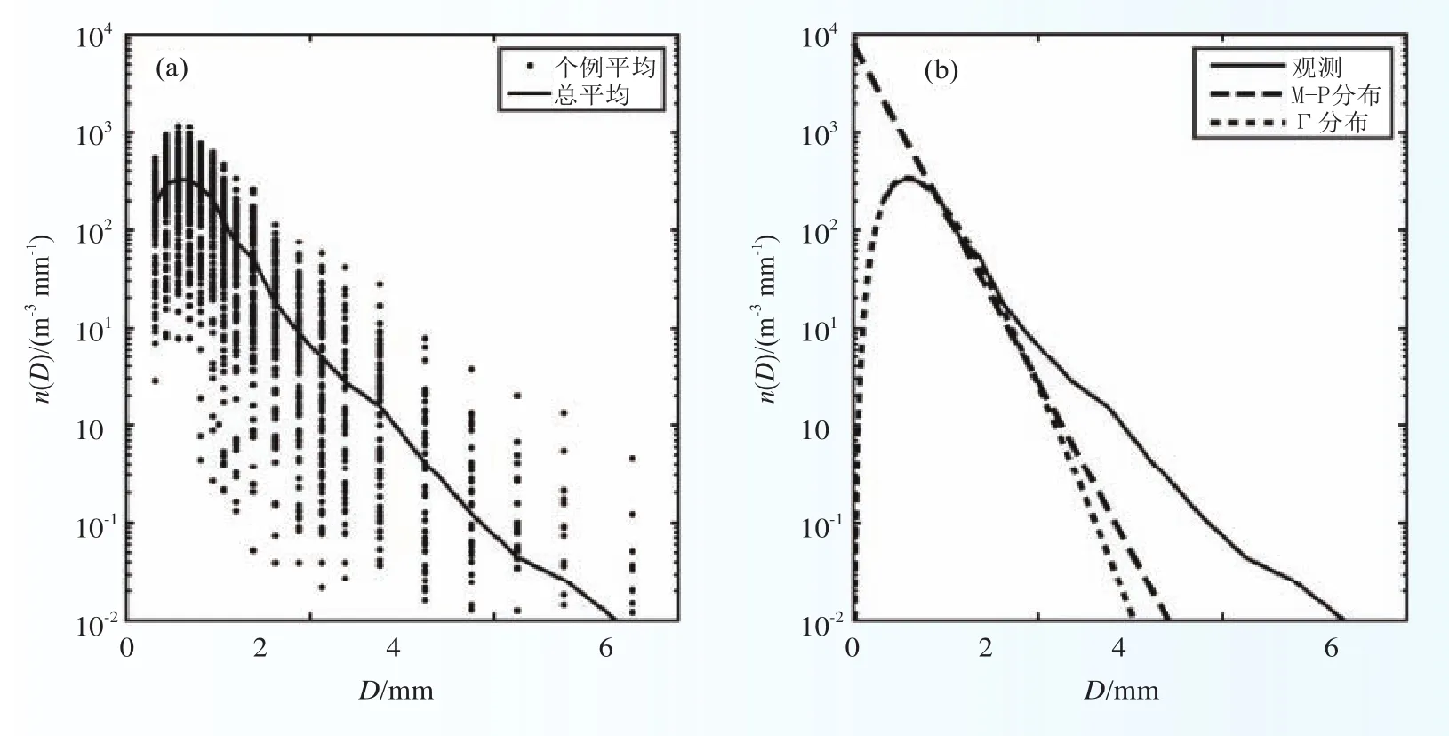
图1 112次降水的平均雨滴谱和总平均雨滴谱(a),平均雨滴谱、M-P分布雨滴谱以及拟合的Γ分布雨滴谱(b)Fig.1 Raindrop size distribution: (a) Mean raindrop size distribution of 112 rainfall events and totally mean raindrop size distribution; (b) Mean raindrop size distribution, M-P raindrop size distribution and Γ raindrop size distribution

图2 北京霾过程中云高仪CL31后向散射信号(a)、微脉冲激光雷达归一化相对后向散射信号的时间高度剖面(b),以及PM2.5浓度和微脉冲激光雷达反演的边界层高度随时间的演变(c)Fig.2 Time-height cross sections of (a) the backscatter density detected by the CL31, (b) the NRB detected by the MPL, and (c)the temporal evolution of PM2.5 mass concentration and PBL height retrieved by the NRB of MPL during the entire haze event in Beijing
图3 新建暖云室结构示意Fig.3 The structural diagram of our new warm-cloud chamber

图4 2017年9月飞机观测的深圳气溶胶垂直廓线Fig.4 Vertical profiles of aerosol observed over Shenzhen, Guangdong Province

图5 冬季庐山云雾个例的雾滴谱(散点)及平均滴谱(曲线)分布Fig.5 The size distribution of fog droplet number (scatter) and their mean distribution (curve) of cloud and fog cases during autumn and winter over the Lushan Mountains
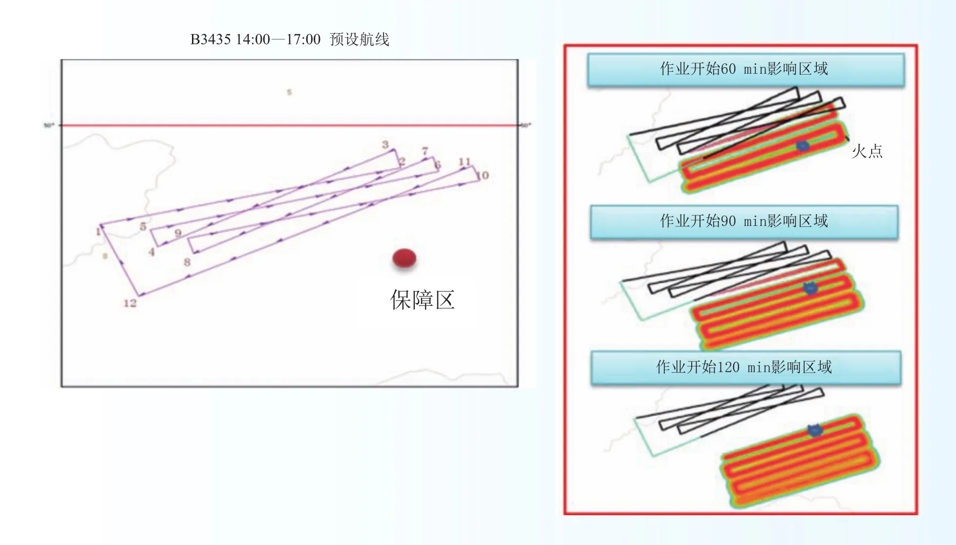
图6 2017年5月5日B-3435增雨作业飞机预设航线及扩散60、90、120 min的影响区域示意Fig.6 The B-3435 aircraft seeding fl ight plan (left), and the spread regions after 60, 90, and 120 minutes (right) on May 5, 2017
Progress in Cloud Physics and Weather Modification
1 Major weather modification projects
1.1 Weather modification project in Northeast China
Precipitation-Enhancement Systems on 2 Xinzhou 60 aircrafts passed inspection.The aircrafts are capable of catalyzing cold and warm clouds, real-time macroscopic cloud detection and ground-air communication;undertaking precise catalyzing and seeding operations, and scientific research; and evaluating weather modification operation, and the other related tasks, with high degree of system integration and automation.
The King Air aircraft has been re-f i tted, inspected and settled in Hebei. Completed the US’ inspections of MDA and STC, with an STC certificate.In early December, the empty aircraft and all the airborne equipment passed the custom’s inspection with a nationality certificate issued by CAAC.
Held 3 training sessions with more than 150 weather modification operational technicians from Northeast China.The “Weather Modification Aircraft Operations and Ground Operations Directing” session mainly aims to training the key weather modification aircraft operationists at the provincial level on the airborne detection instruments operations, rainfall enhancement seeding operations, aircraft data quality control and analysis,and etc.The “Weather Modification Aircraft Operations Management and Onboard Observation and Rainfall Enhancement Operations” session mainly aims to training the weather modification operation personals at the city (league) and county level on the real-time operations that integrate 5-step operations, a platform and 4 systems of weather modification.
Held a project-inspection summary workshop in order to build up the regional weather modification capability in Northeast China.The related project progress and the improved weather modification capability in Northeast China have been reported to the leaders of NDRC and CMA.
All inspection operations have started.The Proposed Weather Modification Project in Northeast China has been released.Both the Xinzhou 60 precipitation enhancement aircraft and the ground operation directing application system have passed inspections.(Equipment R&D and Support Division, Operation Commanding and Running Centre)
1.2 Development of weather modification projects in Northwest China
Completed preliminary design of a Weather Modification Project in Northwest China that was later approved by the NDRC, and activated in operation with the 2017 project implementation plan in place.Established a regional weather modification administrative office with appropriate personnel in Northwest China.Developed and then carried out the relevant administrative measures.(Regional Centre Administration Office)
1.3 Weather modification projects in other regions
Completed and submitted “the Feasibility Study Report (FSR) of Weather Modification Project in Central China” to the NDRC for evaluation.The FSR has now been modified in response to the evaluation comments.Similar FSRs for Weather Modification Projects in North, Southwest and Southeast China are in progress.One technical review has been carried out and the relevant updates are on going based on the review comments.(Regional Centre Administration Office)
2 Progress in scientific research
2.1 Assessing cloud-water resources and their utilizing demonstration
We have put forward and improved the concept of using cloud-water resources, and assessing theory and methodologies.Optimized the diagnosis of three-dimensional cloud and cloud-water field in different regions of China, and completed the diagnosis of cloud-water resources from observations obtained since 2000.Validated some key parameters and diagnosed results against satellite, aircraft and ground-based observations.Meanwhile, we designed and developed numerical models for cloud-water resource assessment and impact estimate, which are capable of simulating cloud precipitation process and evaluating regional cloud-water resources.Additionally, we proposed a quantitative evaluation model for the impact of cloud water resources on regional water resources, and obtained preliminary results of utilizing cloud-water resources on regional water resource supply and demand.In practical, we carried out the studies of key technologies and operations of conducting artificial rain enhancement in two types of fixed target areas: one at Danjiangkou that is a water source demonstration site at the middle portion of the South-to-North Water Diversion, and another in Beijing where two reservoirs are located.Therefore, abundant scientific data of observations and cloud catalytic operations were obtained, with significant progress made in both the numerical simulations of cloud-water resources over the fixed target areas and the evaluation of multi-parameter physical inspection and assessment.(Operation Commanding and Running Centre)
2.2 Analysis of cloud physics products and demonstration of weather modification application both with FY-4 stationary satellite
Macroscopic cloud parameters are retrieved from FY-4A satellite, ground and rawinsonde observations,with the cloud base height validated against ground-based lidar observations.Algorithms of detecting clouds and distinguishing supercooled water from cloud phase from FY-4A satellite are developed, and the products so retrieved are compared with the same products from H8 and MODIS satellites and in-situ aircraft observations.Based on FY-4A multi-channel observation thresholds, we developed an algorithm to classify target clouds of weather modification operation and explored the associated monitoring in an operational setting.Upgraded the FY-4A satellite retrieval products of both the macroscopic and microscopic cloud structures and Cloud Precipitation Analysis System (CPAS).Using aircraft, satellite and various ground-based observations, we carried out ground-space validation observations for macroscopic and micro cloud physical parameters retrieved by FY-4 satellite.The results have been used to serve for the Tianjin National Games.Meanwhile,we have demonstrated applying FY-4A products to the five-steps weather modification operation.(Operation Commanding and Running Centre)
2.3 Randomized rain enhancement experiment and impact evaluation
Randomized rain-enhancement experiments were continued in 2017 over the testing areas of four provinces.A total of 43 samples for rocket rain enhancement experiments and 2 samples for airplane rain enhancement experiments were conducted.During these experiments, all the relevant cloud and precipitation data from satellites, radars, upper-air soundings, surface raindrops, and ground rainfall, as well as rain enhancement data were collected timely to supplement and improve our sample database.A preliminary analysis of some examples of randomized rain enhancement experiment in 2017 has been carried out.
We have improved the impact evaluations of randomized rain enhancement experiments conducted over Shandong, Fujian, and Jilin provinces, and the corresponding software that are suitable for local ground rainfall, and also improved the evaluation method for their own radar-based and the corresponding software of rain enhancement experiment over Fujian and Hainan provinces.(Operation Commanding and Running Centre)
2.4 Rain enhancement potential and seeding technology in large cloud system over southern China
The project of “Rain Enhancement Potential and Seeding Technology in Large Cloud System over Southern China,” together with microwave radiometers, have established the statistical retrieval relationship between radar echoes and effective cloud droplet diameters in autumn and winter over Jiangxi Province,improved the cloud microphysical retrieval system with the FY-2 and the Sunflower stationary satellites,developed the satellite index of cold stratiform-cloud precipitation enhancement, conducted the development and improvement of the cloud microphysical retrieval system associated with the FY-4 high resolution stationary satellite, and carried out a cloud physical field detection experiment in Yibin of Sichuan Province.(Regional Centre Administration Office)
2.5 Optimizing a statistical effect analysis scheme for the non-randomized rain enhancement effectiveness evaluation
Studies were carried out in 2017 on the effects and scope of airplane rain enhancement experiment conducted in the winters of 2008 to 2014 on the seasonal rainfall over Jiangxi Province.Nine target stations and twelve downwind stations were selected as the studied objects according to the mean wind direction of 71 cloud-seeding operations in 7 years.A group of 5 control stations that provided the highest correlation of the mean seasonal precipitation with the selected 21 stations was determined.Linear regression equations between the control group and each downwind station were established.Key findings obtained from this study are summarized as follows.Average wintertime rainfall increased by 17.30% (p=0.25) and 21.67% (p=0.0013) for target and downwind regions, respectively.The results showed that the positive seeding effect can be detected as far as 126 km downwind of the target region.(Operation Commanding and Running Centre)
2.6 Results from the measurements of natural ice nuclear particles in Beijing during spring 2017
In these measurements, INPs concentrations were observed twice a day (09:00 am and 02:00 pm) in Beijing from Mar 20 to Apr 19, 2017 using the 5 Litters Bigg’s mixing cloud chamber.The methodology, time and sites of the observation are basically the same as those conducted in the years of 1963, 1995 and 1996.The observed activation temperatures were –10 °C, –15 °C, –20 °C, –25 °C, and –30 °C.Results show that INPs concentrations at the different activation temperatures have good consistency trend as diurnal variation.This is consistent with the observations obtained in 1963, 1995 and 1996.The INPs concentrations in the present observations are higher than those observed in 1963, but obviously lower than those observed in 1995 and 1996.This implies that natural changes and human activities in the past 20 years did not significantly increase the INPs concentration.During the observing period, because of weak precipitation occurring intermittently on Mar 20–25, the INPs concentrations decrease on these days.That is, precipitation has the effect of removing ice nuclei.The visibility sensor was also synchronized in this work.Results show that the trend of INPs concentrations and visibility is inversely correlated from day to day changes.The correlation coefficient between INPs concentrations at –25 °C and visibility is –0.51.Fog-haze weather occurred many times during the observing period, and in the absence of precipitation, visibility is directly affected by the severity of foghaze.The INPs concentrations have been compared to the other meteorological variables.Results show that the INPs concentrations have negative correlation with wind speeds but positive one with relative humidity,indicating that the better diffusion conditions, the less INPs.Inverse correlation between INPs and pressure was previously proposed, but found not obvious in the experiment.(Equipment R&D and Support Division)
2.7 Cloud and precipitation over the Tibetan Plateau
Using surface observations and FY-2E satellite TBB data from July 1 to August 31, 2014, we studied the characteristics of convective clouds and precipitation as well as raindrop size distribution over the Tibetan Plateau.Results show that convective activity appeared mainly in the central and southeastern part of the Tibetan Plateau and precipitation had a quasi-two-week cycle during the observational period.Because of solar heating, both convective clouds and precipitation had obvious diurnal variations.Few convective clouds occurred during the morning hours.Convective clouds first appeared at 11:00 BST, and then they merged,reaching to their maximum extent during 17:00–18:00 BST.At night precipitation tended to be advective and lasted until 6:00 BST when it began to dissipate.The mean cloud-top height was around 11.5 km ASL, and its maximum value exceeded 19 km ASL.The mean cloud-base height was 6.88 km ASL during the observing period.Precipitation was mainly short-lived, usually less than 1 h, in the form of shower with a mean intensity of 1.2 mm h–1.Results also show that the raindrop size distribution over the Tibetan Plateau was wider than that over the plain area at the same latitude and season, because rainfall could be more easily produced over the plateau than that over plain.Γ distribution was found to be more suitable for the raindrop size distribution than M-P distribution over the Tibetan Plateau.
In addition, multi-source satellite data from TRMM, CloudSat and Aqua and ground-based vertically pointing radar data are used to examine the vertical structure of a deep convective cell that occurred over Naqu during 13:00–16:00 BST on July 9, 2014 of the third Tibetan Plateau Atmospheric Science Experiment.Results show that (1) Radar reflectivity increased sharply across the 0 °C level, suggesting the important roles of melting solid precipitation particles in the deep convective cloud; (2) Bright bands appeared during its weakening period; (3) Deep convective clouds were composed mainly of ice particles, with considerable amount of small ice particles above 10 km and fewer large ones below 10 km; (4) Deep convective clouds contained mainly mixed-phase and glaciated processes (Fig.1) (Open Laboratory)
2.8 The relationship among PM2.5 concentration, visibility and PBL height during long-lived haze and fog-haze mixed events in Beijing
Using observations obtained by several state-of-art instruments, including Micro Pulse Lidar (model MPL-4B), particulate monitor (model TEOM 1405-DF), ceilometer (model CL31), visibility sensor (model PWD20) and profiling microwave radiometer (PMWR, model 3000A) as well as conventional meteorological instruments during the field campaign for haze and mixed fog-haze events in northern China, we investigated and quantified the relationship among PM2.5mass concentration, visibility and planetary boundary layer (PBL)height during four long-lived haze events and seven mixed fog-haze events from January 2014 to March 2015 in Beijing.Results show a negative exponential function between visibility and PM2.5mass concentration during both haze and mixed fog-haze events (with the sameR2of 0.80).However, the fog-haze events caused a more obvious decrease of visibility than that for haze events due to the formation of fog droplets that could induce higher light extinction.The PM2.5concentration had inversely linear correlation with the PBL height for haze events and negative exponential correlation for the mixed fog-haze events, indicating that the PM2.5concentration is more sensitive to the PBL height in the mixed fog-haze events.Visibility had positively linear correlation with the PBL height with theR2of 0.35 in the haze events and positive exponential correlation with theR2of 0.56 in the mixed fog-haze events.We also investigated the physical mechanism responsible for these relationships among visibility, PM2.5concentration and PBL height through the typical haze and mixed fog-haze event, and found that a double inversion layer formed in both typical events and played critical roles in maintaining and enhancing the long-lived polluted events.The variations of the double inversion layers were closely associated with the processes of long-wave radiative cooling during the nighttime and short-wave solar radiation reduction during the daytime.The upper-level inversion layer formed by the persistent southwest warm and humid airflow while the low-level inversion layer was initially produced by the surface long-wave radiative cooling during the night time and maintained by the reduction of surface solar radiation in the daytime.The obvious descending process of the upper-level inversion layer induced by the radiative process could be responsible for the enhancement of the low-level inversion layer and the lowering PBL height, as well as high aerosol loading for these polluted events.The reduction of surface solar radiation in the daytime could be about 35% for the haze events and 94% for the fog-haze mixed events.Therefore, the formation and subsequent descending of the upper-level inversion layer should be an important factor in maintaining and strengthening the long-lived severe pollution events, which has not been revealed by previous studies.The interactions between the PM2.5concentration and PBL height linked by radiative process caused a more significant and long-lasting deterioration of air quality and visibility in the mixed fog-haze events.The interactions of all these processes were particularly strong when the PM2.5mass concentration was larger than 150–200 μg m–3(Fig.2).(Open Laboratory)
2.9 Cloud chamber and seeding agents
We finished designing the structural and performance monitoring systems for a new warm-cloud chamber,and conducted some preliminary tests under an operational setting.Then, the main framework, the monitoring instrument selection, the mode and electric control and the display control cabinets of the chamber were designed and built.We set up a new IN-testing chamber, and transported and installed in Beijing.It is ready for various debugging.Some warm seeding agents experiments have been carried out in our Lab.Preliminary results show that the agents have some capability of influencing warm mist and fog.Some formula will be further improved(Fig.3).(Open Laboratory, Equipment R&D and Support Division)
3 Scientific achievements and applications
3.1 Operational running the Cloud Permitting Forecast System
The Cloud Permitting Forecast System (CPFS_V1.0) has been operationally running since July 28, 2017.The CPFS forecasts divide mainland China into 8 regions, with 31 forecast products released twice a day in real time at the temporal and spatial resolutions of 1 h and 3 km, respectively.As compared to the Weather Modification Forecast Model System (2013 Version), 5 additional forecast products, including cloud-base height and temperature, radar echo, cloud cover and relative humidity, are provided.With this model system,weather modification forecast service for different targets could be carried out.Based on the predicted cloud structures and evolution, potential seeding areas, timing and seeding plans can be executed with better service.(Operational Commanding and Running Centre)
3.2 Development of the seeding simulation technology and its operational effectiveness
We obtained simulations of flight and rocket seedings using CAMS cold-cloud seeding scheme.This allowed us to evaluate the effectiveness of multi-f l ight seeding to mixed-phase clouds, and rocket seeding to summer convective clouds.(Operation Commanding and Running Centre)
3.3 Supercooled water identification from airborne and remote sensing observations and their applications
A method to identify supercooled water from airborne particle spectrum and two-dimensional images was proposed based on DMT and PMS aircraft cloud physical detection.Through many case studies, we showed satellite-observed cloud characteristics in the super-cooled water and the ice cloud regions and developed a satellite-monitoring and identifying method for supercooled water regions by combining RGB composite images, T-Re relationship features and cloud parameter spectrum distribution.Through the space-time matching of aircraft detection and radar observations, the radar echo characteristics in the supercooled water area were statistically studied, and a method of synthetically identifying supercooled water areas using radar echo top temperature, echo intensity, and echo gradient was developed.Furthermore, an analysis software was designed to not only support the identification of weather modification conditions, but also assist in the aircraft icing monitoring and forecasting service.(Operation Commanding and Running Centre)
3.4 Impact evaluation of seeding different clouds
We have explored the development of reasonable impact evaluation methods for seeding different clouds with different operation modes in order to satisfy different business requirements, such as establishing a work flow and exploring new evaluation methods.The rationalities of these methods are consistent with operation modes and catalyst doses.That is, after selecting a contrast area, observation data from radar, satellite and surface rainfall are used to evaluate the impacts of cloud seeding.Two different methods are developed: (1)Regional Multi-Parameters Dynamic Evaluation for stratus clouds; (2) Echo Tracking Identification Evaluation for convective clouds.Both have been applied to the weather modification service in many important events.(Operation Commanding and Running Centre)
3.5 Development of the accurate processing analysis of cloud-precipitation system (APACS)
The accurate processing analysis of cloud-precipitation system (APACS) is a meteorological system that integrates cloud physics analysis technology, AuroView geographical information and image, and computing technology.The APACS has the function of accurate monitoring and predictive analysis of multi-scale cloudprecipitation physics variables.Aiming at the structural and evolution features of precipitation, this system can process observational data from multi-platforms (e.g., satellite, radar, sounding, rainfall, airborne microphysics measurements, and etc.).In addition, it can perform real-time comprehensive analyses of cloud structures and tracking recognition through integrated retrievals, and has the function of processing and analyzing multiscale dynamics and cloud physics products.On this basis, the APACS can have the operational functions of weather modification, such as the operating condition forecast analysis, monitoring and identification, seeding plan design, tracking control and seeding impact analysis, and can deal with different operational demands,such as precipitation enhancement by aircraft or rocket artillery and hail suppression.The APACS also has the functions of precipitation phase recognition, aircraft icing analysis and severe convection identification(rainstorm vs.hail) as well as producing many other special products.This system has been converted to scientific and operational versions (e.g., APACS 2.0, APACS -WMC, and APACS -NE series), respectively, in order to meet with different needs of scientific research and cloud seeding operation.We have obtained several software copyrights in 2017.Driven by the “Three-Year Weather Modification Project”, the APACS has been applied in more than 20 provinces and 400 cities.By supporting scientific research, weather modification operations and engineering projects, the core technology of this system has been continuously upgraded, which has plays an important role in conducting daily weather modification operations and in serving important events.(Operation Commanding and Running Centre)
3.6 A comprehensive weather modification system used in Northeast China
The National Weather Modification Center accepted a comprehensive weather modification system in Northeast China in 2017 after inspection.This system consists of “one platform and four systems”, which has enabled Northeast China to achieve technological progress in three areas as described below:
First, it has established an integrated operational platform (APACS-NE) that adapts to regional-provincial-city-county operational demands, fully supporting the five levels of weather modification operations.Second,all data at each level have been standardized and stored.Third, the information (instruction) transmission channels have built at all levels from the regions to provinces, cities, counties, and to the point of operation.Therefore, this system has the functions that “commands can go through, information can be collected from,and data can be stored” at all the levels.The core system architecture with “one platform and four systems”has been designed and realized with high interconnection in function and low coupling between systems,and can be flexibly disassembled and deployed.As an example of a typical weather modification operational system, the software and its structure are included in the Guide to the Construction of an Integrated Weather Modification Operation System and promoted to the whole country of China.(Operation Commanding and Running Centre)
4 Scientific field experiments
4.1 Aircraft observations during field experiments
From March to April 2017, seven airborne observation field experiments associated with Southwest vortices in Hubei were carried out in view of the to-be-tested fl ight plans in Yichang.From August to October 2017, a high-performance rain-enhancement aircraft was used for the first time in China to observe the peripheral clouds of a typhoon and test a joint real-time air-ground command system through a maritime satellite.This field experiment lasted for almost a month with six flights and collected aerosol and cloud microphysics data.We analyzed twelve aerosol vertical profiles obtained over Shenzhen, Guangdong Province and microphysical characteristics of shallow cumulus clouds in southern China.Results show that the aerosol number concentration near the ground varied greatly from 500 to 9000 cm–3under different weather conditions.Aerosol spectrum showed little variations in the daytime boundary layer, which were mainly bimodal or trimodal.On September 24’s flight ice particles in the forms of plate- and needle-shaped ice crystals were observed at 6 km altitude, where the minimum temperature was –6 °C as the aircraft was fl ying into the clouds(Fig.4).(Open Laboratory, Aircraft Operational Centre)
4.2 Cloud and fog observations over the Lushan Mountains
The Lushan cloud-fog field station resumed its operation after its re-construction in November 2015,and set up an observational platform equipped with modern instruments.Field experiments of cloud, fog and precipitation in Lushan were carried out in 2017, using the newly installed instruments, including fog-drop spectrometer, disdrometer, ceilometer, visibility sensor, micro-rain radar and automated meteorological station.A sizeable of observation data of cloud and fog and different precipitation cases have been obtained, such as freezing rain, snowfall, plume rain, rainstorm and etc.
The above observations taken during the autumn and winter of 2015 over the Lushan Mountains were analyzed.Results show that the cloud and fog droplet spectra have a bimodal pattern with double peak particle sizes at 6 μm and 12–15 μm, respectively, and the number concentration peaks of both particles reached the order of more than 10 μm–1cm–3with their maximum values as large as 93 μm–1cm–3.The cloud and fog droplet spectra were wide, with the particle size approaching drizzle drops.Precipitation was dominated by light rainfall.As the rainfall intensity increased, wider raindrop spectrum, and narrower cloud droplet spectrum could be seen, suggesting the presence of obvious in-cloud collision processes.Due to the high altitudes of the Lushan Mountains, the lower cloud base of precipitating clouds was the main reason for the presence of longlived cloud and fog.Abundant water vapor appeared after precipitation, prevailing in northerly winds with the average speed of 2.9–4.5 m s–1, which favors the formation of evaporation fog (Fig.5).(Open Laboratory,Equipment R&D and Support Division)
5 Weather modification operation and service
5.1 Weather modification commanding operation
We issue 7 types of satellite-retrieved cloud products, and 4 major categories with 20 sub-category model forecast products based on 3 modeling systems across China at a daily basis; collect real-time national fl ight and ground-based operational data; provide weekly weather modification requirements analysis, a weekly newsletter on “National Weather Modification in the Forthcoming Week”, a monthly newsletter on “National Weather Modification Qualify Report”, and a quarterly newsletter on “National Weather Modification Status”.
Relying on the continuous improvement of a fine cloud-precipitation forecast system and monitoringidentification techniques as well as operational design and command capability, we have provided cloud seeding service for North China, regional drought in Northeast China, the Bilahe and Wuma forest fire in Inner Mongolia, the 90th anniversary military parade, the Inner Mongolia 70th anniversary activity, the thirteenth National Sport Games in Tianjin and other service.In addition, we have published a total of 41 Cloud Seeding Potential Forecast Reports, 6 Early Warning Reports, and 5 Flight Plan Reports; organized 25 video conferences, released 2 quality reports on National Aircraft Operation Scheme Design, and 10 fl ight operations of weather modification all with satisfactory service to our customers.We have also accomplished several highimpact emergency disaster tasks, including the suppressing forest fire events in the Daxinganlin Mountains on 2 May 2017 and in Qinhuangdao on 25 April 2017.
The CPEFS_V1.0 operational model, with a 3 km horizontal resolution, has been used to predict the development of convective and stratiform clouds as well as their movement, vertical structures and precipitation.For example, its accurate 24 h forecasts played an important role in suppressing rainfall operations during a weather modification service to Inner Mongolia’s 70th anniversary activity, which was achieved by adding moveable rocket seeding equipment at its northwest defense areas.
During a suppressing forest-fire emergency service in Hulun Buir Bilahe, given the target forest-fire area and the performance of Xinzhou 60 aircraft, we designed a full seeding operation plan, in which a longduration seeding diffusion range was collocated with the Bilahe forest fire area, in order to achieve the best precipitation result at the target fire area.Results show that the 24 h cumulated rainfall in the fire area reached 39.2 mm after the seeding operation, while small to moderate rainfall occurred over the surrounding areas,indicating very obvious impact in rain enhancement.This work has been appreciated by the State Forestry Fire-Prevention Headquarter, and the Government of the Inner Mongolia Autonomous Region (Fig.6).(Operation Commanding and Running Centre, Aircraft Operational Centre)
5.2 Weather modification aircraft operation
(1) Drought resistance service in northeastern regions and other provinces.We have seriously provided services in drought-resistance, reservoir filling, environmental protection, and fire prevention over forest and grasslands using national weather modification aircrafts in the four northeastern provinces.To meet the needs of fire prevention over forest and grasslands during spring and summer, two weather modification aircrafts, i.e.,B-3435 and B-3726, based on Longjia airport in Changchun and Taoxian airport in Shenyang, respectively,were used to provide the services in drought resistance and reservoir filling over the Jiagedaqi region in Heilongjiang and Hulun Buir in Inner Mongolia.
To meet the requirements of drought-resistance and normal seeding over the Central Plains and Hetian,the weather modification aircraft B-3726, based on Xinzheng Airport in Henan and Hetian Airport in Xinjiang,provided aircraft seeding service over their regions and neighboring areas, in collaboration with the Weather Modification Departments of Henan Province and Xinjiang Autonomous Region.(Aircraft Operational Centre)
(2) Research to operation transformation and foreign exchange.A Weather Modification Airborne Observing Laboratory was set up in China Meteorological Science Park in Changping, jointly with the Huayun Meteorological Technology Group Corporation in order to provide an open platform for weather modification aircraft-observing equipment, conduct scientific research and application, improve equipment performance with technological innovation, and facilitate research-to-operation transformation, and technical consulting.Therefore, the laboratory is expected to provide a solid weather modification aircraft platform and strong support for reliable operation of on-board cloud physics detection equipment.
To conduct the operational mini-project of the CMA’s “The Full-Range Monitoring and Control of Operational Weather-Modification Seeding Ammunition Demonstration” and the CAMS’ special science project of “Application of Tracers to Evaluating Rain-Enhancement Effects” as well as the other scientific studies, we took charge of establishing “the Standardization of Coding Technological Criteria for Weather Modification Equipment and Seeding Ammunitions” and “How to Monitor and Manage Weather Modification Equipment and Seeding Ammunitions”.In addition to formulating the technology criteria, we promoted their applications nationwide.
We have actively participated in foreign exchange and collaborative activities by sending some staff to the United States to receive training on the use and maintenance of airborne remote sensing equipment such as airborne cloud particle detection equipment and laser radar; and actively attending seminars and lectures held by experts from domestic universities and research institutions on aerosol and cloud and precipitation physics.Moreover, the training and technical exchange of on-board detection equipment applications were carried out in collaboration with the USA’s DMT (Droplet Measurement Technologies) company, which strengthened the cultivation of young scientific and technologic talents and the construction of a professional team of national aircraft operation and management.(Aircraft Operational Centre)
(3) Detective equipment and aircraft maintenance.The regular inspection and calibration of the DMT particle measurement system were completed in accordance with the required procedures.The fixed inspection and maintenance of two Xinzhou 60 aircraft are organized and implemented, i.e., 12 months (Yichang), 18 months (Luoyang), and 24 months (Yanliang); and the trusteeship of Kingair and Xinzhou 60 aircraft was bided.(Aircraft Operational Centre)