Characteristics analysis and model prediction of sea-salt water intrusion in lower reaches of the Weihe River,Shandong Province, China
2016-12-12WANGJiningMENGYonghui
WANG Ji-ning, MENG Yong-hui
Geology and Environment Monitoring Station of Shandong Province, Jinan 20014, China.
Abstract: Marine sedimentary strata are widely distributed in the coastal zone of the study area, and are rich in brine resources. The exploitation of underground water resources often first caused the intrusion of salt water in the marine strata. Based on the analysis of sea-salt water intrusion feature, the sea-salt water intrusion is divided into four stages: The occurrence and development stage (1976-1985), the rapid development stage (1986-1990), the slow development stage (1990-2000) and the stable development stage (2000-2015). Based on the comparative analysis of the relationship between seawater intrusion and influencing factors,this paper presents that the groundwater exploitation and the brine resources mining are the main control factors of sea-salt water intrusion. On this basis, we have established a numerical model of the sea-salt water intrusion. Using this model, we predicted the development trend of the sea-salt water intrusion. The results show that if the current development of groundwater and brine is maintained, the sea-salt water intrusion will gradually withdraw; once development of brine stops, sea-salt water will invade again. This provides the scientific basis for the rational exploitation of groundwater and the prevention of sea-salt water intrusion.
Keywords: Sea-salt water intrusion; Marine sedimentary strata; Brine resources; Numerical simulation; Influencing factors
Introduction
Seawater intrusion is a common geological environment problem in coastal areas. It is the result that the factors of the natural and human activities affect a specific area. Seawater intrusion will lead to the groundwater quality deterioration and soil salinization, which brings many adverse effects and great harm to the ecological environment and social economic development.Seawater intrusion has caused the international community's common concern. Back in the nineteenth century, J Du Colnrnun (1828),Badon-Ghyben (1889) and Herzberg (1901) gave the depth expression on the salty fresh water interface (Jacob Bear, 1983). The seawater intrusion has become a hot issue of the coastal zone environmental geological study in the 1960s,Seawater intrusion problem has been found in Australia's Melbourne, Canberra, Sydney and Japan's Shizuoka Fuji City, west Osaka, then the monitoring work were carried out and to groundwater pumping plan was developed. By changing the flow field of groundwater, seawater intrusion hazard has been effectively controlled(YIN Ze-sheng, et al. 1991). Custodio (1985), at the 18thsession of the International Association of Hydrogeologists (IAH) meeting, comprehensively introduced the current situation of seawater intrusion, the basic principles, geological conditions, groundwater exploitation influence, calculation method, monitoring techniques, freshwater resource management and so on (Custodio E,1987).
Over half a century, the great progresses have been made in the investigation of the current situation of the sea water intrusion, the basic theoretical exploration, the development of the model, the prediction and prevention measures(Peter S Huyakorn et al. 1987; XUE Yu-qun et al.1993; CHENG Jian-mei et al. 2001). The direct driving force of seawater intrusion is the change of groundwater level in the coastal zone. The main causes of seawater intrusion are climate change,the sea level rise, the over exploitation of groundwater and other natural and anthropogenic factors (Ataie Ashtiani B et al. 1999; CAO Jian-rong. 2002; HUANG Lei and GUO Zhan-rong,2008; FENG Ai-ping et al. 2006). In different coastal zones, the geological and hydrogeological conditions are different, the characteristics of groundwater flow system are also different, and the factors that affect the migration of salty-fresh water interface are also different. According to the lower reaches of Weihe River with the specific hydrogeological conditions, this article analysed the sea-salt water intrusion characteristics,established the numerical model to predict, and provided the scientific basis for the rational exploitation of groundwater and the prevention of sea-salt water intrusion.
1 Geological background of study area
The study area is located in Changyi City,Shandong Province, China. From Changyi City to the coast, the sedimentary strata were alluvialpluvial strata, alluvial-marine sedimentary strata and marine sedimentary strata (Fig. 1).
The quality of the groundwater in the stratum is also basically compatible with the formation. The groundwater in alluvial-pluvial deposits is generally fresh water (the mineralized degree less than 2 g/L), and is also the main source of water supply in the area. The groundwater in marine sedimentary strata is generally salt water (the salinity is generally greater than 50 g/L, maximum up to over 100 g/L), and is a very good brine resource. The groundwater quality in alluvialmarine sedimentary strata is also adapted to the formation origin, the upper part is salt water, and the lower part is fresh water. Due to the sedimentation of the modern river, the groundwater quality in the local zone can be divided into three layers, the upper fresh water, the middle salt water and the deep fresh water.

Fig. 1 Stratigraphic sedimentary type distribution map
2 Analysis of evolutionary characteristics of salt-fresh water interface
Although the distribution of salt water and fresh water is influenced by the sedimentary background of the formation, the salt-fresh water interface will also be changed under the action of hydrodynamic conditions. Since the 1970s,influenced by the natural factors and human activities, the salt-fresh water interface appeared to advance inland (i.e. the beginning of the invasion of sea-salt water). From the 1970s to now, the process of sea-salt water intrusion can be divided into four stages:
The first stage is the occurrence and development stage (1976-1985). Because of the decrease of precipitation, the increase of evaporation, and the increase of water demand in industry and agriculture, the groundwater level was decreased,the sea-salt water intrusion began to occur. Sea-salt water intrusion occurred at the beginning, the invasion rate was slower, the invasion area was smaller, and mainly the local invasion. By 1985,the sea-salt invasion area was expanded, intrusion range was developed from local to regional, the largest distance of intrusion was about 6 km in the area north of Long-chi Town.
The second stage is the rapid development stage (1986-1990). Due to excessive exploitation of groundwater in Changyi City, the groundwater level declined drastically, groundwater funnel expanded continuously, sea-salt water intrusion rate reached at 1.44 km/a, the largest distance of intrusion was about 12 km in the area south of Qing township.
The third stage is the slow development stage(1990-2000). This stage, people gradually realized the harm of sea-salt water intrusion. The exploitation of groundwater was restricted appropriately, and exploitation of brine was increased year by year, the sea-salt water intrusion rate slowed down, even salt-fresh water interface flinched in some areas. The salt-fresh water interface flinched 8 km in Liutuan town-Qing township area.

Fig. 2 The sea-salt water intrusion front line change map
The fourth stage is a stable development stage(2000-2015). By the regulation of the exploitation of groundwater and brine, the salt-fresh water interface was well controlled within a certain range(Fig. 2). The contour of salinity 2.5 g/L was used as the sea-salt water intrusion front line, and the sea-salt water intrusion front line was basically in a hovering state during this stage.
3 Factors affecting the migration of salt-fresh water interface
Factors influencing the migration of salt and fresh water interface can be divided into natural and man-made factors, natural factors include mainly geological conditions, atmospheric precipitation and storm surges, man-made factors include mainly groundwater exploitation and brine exploitation. According to the change of salt water interface in the study area, the exploitation of groundwater resources and the exploitation of brine resources played a decisive role.
The study area is a typical silty mud coast, the Quaternary sedimentary thickness is larger,generally 200-300 m. The stratum sediments include mainly marine sediments, lacustrine sediments, and fluvial alluvium. The paleochannel formed by rivers, the permeability of which is high and it is the good channel of the sea-salt water intrusion.
Since the 1970s, along with the social and economic development, the demand of water resources is increasing, the intensity of groundwater exploitation is also increasing, so that the groundwater level in the area is decreased greatly(Fig. 3), the groundwater depression cones has formed, which provides the hydrodynamic conditions for sea-salt water intrusion.
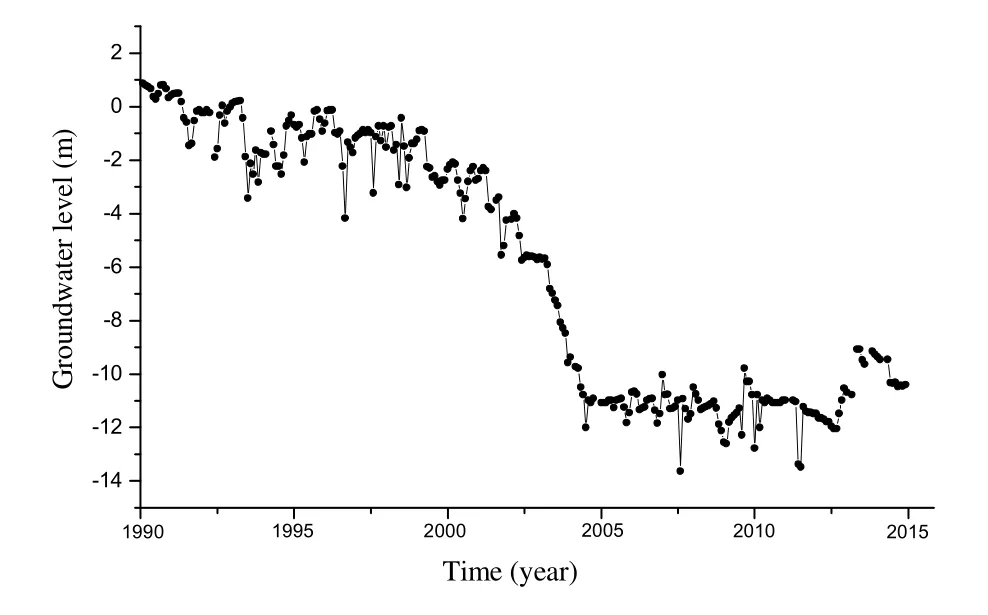
Fig. 3 Water level change curve of groundwater exploitation area
Atmospheric precipitation is conducive to the replenishment of surface water and groundwater,which can also play a role in preventing the sea-salt invasion. Affected by the global climate change, the atmospheric precipitation in recent fifty years showed a decreasing trend (Fig. 4), the surface water resources are in short supply, people increase the exploitation of groundwater, as a result, sea-salt water intrusion intensified.

Fig. 4 Atmospheric precipitation anomaly map
In the coastal zone, there are abundant brine resources. With development of brine resources,the groundwater level continue to decline, the groundwater depression cones has formed in the brine area (Fig. 5), the hydrodynamic conditions of groundwater has been changed,which is one of the reasons for the relatively slow and even recession of the sea-salt water intrusion in recent years.
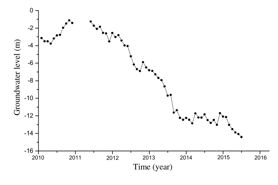
Fig. 5 Curves of groundwater level in the brine exploration area
4 Sea-salt water intrusion numerical model
4.1 Hydrogeological condition generalization
Based on the hydrogeological conditions of the study area, the model region is located in the lower reaches of the Weihe River basin, the boundary on the south is at the top of the Weihe River alluvial fan, the boundary on the north is to the coast line,the boundary on east is in the junction of the Weihe River and the Jiaolai River alluvial formation, the boundary on west is in the junction of the Weihe River and the Bailang River alluvial formation, the area is 946.75 km2. The aquifer is mainly composed of the diluvium, alluvium, marine sediment. The thickness of the alluvial-pluvial strata in the south is large, the grain size is coarse,and the permeability is high. The thickness of the marine-alluvial strata in the north is relatively small, the grain size is fine, and the permeability is low.
According to the aquifer structure, the aquifer can be simplified to three good aquifers. According to the aquifer permeability, the aquifer is generalized as the heterogeneous isotropic aquifer.The boundary of the northern coastline is taken as the boundary of the given water level, and the south, east and west boundary are all treated as the flow boundary. The groundwater flow system is simplified as a three dimensional unsteady flow system.
4.2 Mathematical model
According to the generalized hydrogeological conditions, the mathematical model can also be established as follows:

where, H is groundwater level [L]; Kijis seepage coefficient tensor [LT-1]; ηis density coupling coefficient,sε/Cη=,00sρ/)ρ(ρε−=, CSis concentration corresponding to the maximum density (sρ) of the fluid [ML-3]; ρis density of mixed solution [ML-3]; ρ0is reference density(density of fresh water) [ML-3]; C is solution concentration [ML-3]; ejis jth component of unit vector in gravity direction; μsis specific storativity; ϕis porosity; q is groundwater pumping rate per unit volume of pore medium[T-1]; xi, xjare Descartes coordinate system(i,j=1,2,3); H0is initial water level [L]; HBis given ground water level on the boundary Γ1[L];qB2is recharge or discharge intensity on the boundary Γ2[LT-1]; W′is recharge or discharge intensity on the phreatic surface boundary Γ3[LT-1]; H*is groundwater level at every point on the phreatic surface boundary Γ3[L]; Heis altitude at every point on the phreatic surface boundary Γ3[L]; niis unit vector of outer normal on the boundary.
Due to the limitation of the actual data, this simulation only considers the hydrodynamic dispersion problem, and the hydrodynamic dispersion equation is as follows:

where, D is hydrodynamic dispersion coefficient tensor [L2T-1]; µiis the component of the actual velocity of groundwater flow in the xidirection[LT-1]; C*is liquid concentration of the extraction or recharge [ML-3]; C0is Initial concentration[ML-3]; CBis given concentration on the boundary Γ1[ML-3]; C' is concentration of rainfall infiltration [ML-3].
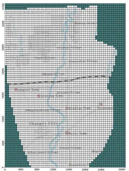
Fig. 6 Simulation grid of the seepage area

Fig. 7 Simulation grid of the seepage area in the vertical direction
4.3 Establishment and solution of numerical model
In order to solve the mathematical model of groundwater movement, the groundwater numerical model is established using the Visual MODFLOW (groundwater simulation professional software) and the numerical model of groundwater was solved using the SEAWAT-2000 program.
The seepage domain is meshed with rectangular grids as shown in Fig. 6, the grid spacing is 125 m, there are 3 787 effective elements in total. According to the generalization of the aquifer, the seepage area in the vertical direction is divided into 5 layers, three layers of aquifer and two layers of poorly permeable strata(Fig. 7).
4.4 Model validation and identification
The model verification and identification are based on the dynamic data of groundwater level and salinity data from January 1, 2011 to December 31, 2012. The verification and identification results of the model are shown in Fig. 8 and Fig. 9. The results indicate that the model is able to reflect the real changes in sea-salt water intrusion.
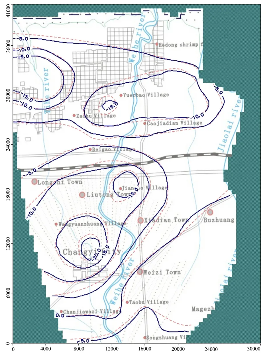
Fig. 8 Contour maps from the modeled and measured groundwater levels (Dec, 2012)
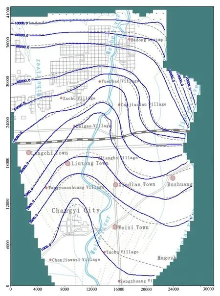
Fig. 9 Contour map from the modeled and measured groundwater mineralization degree (Dec, 2012)
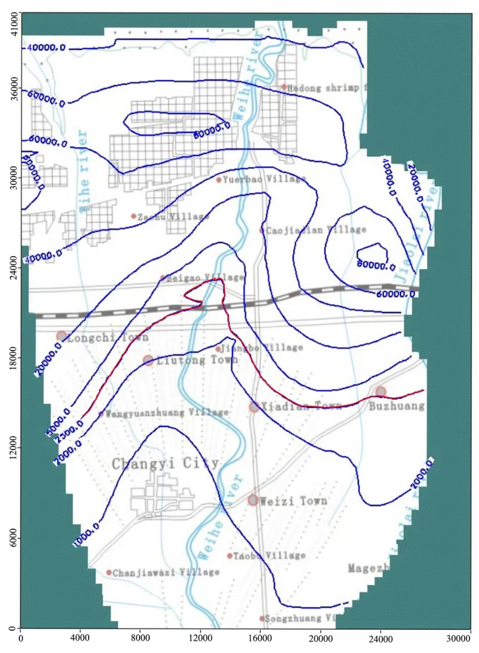
Fig. 10 Contour map from the first scheme forecasted groundwater mineralization degree
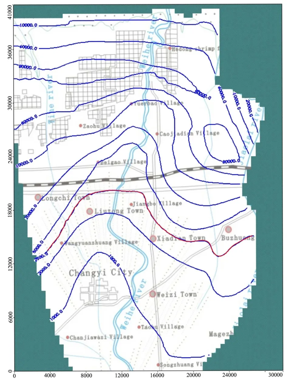
Fig. 11 Contour map from the second scheme forecasted groundwater mineralization degree
6 Conclusions
According to the change of sea salt water intrusion in study area over the past 50 years, sea salt water intrusion can be divided into four stages.The variation of the sea-salt water intrusion front line in different stages coincides with the influence of atmospheric precipitation, groundwater resources exploitation, brine resources exploitation etc. Through the systematic analysis of the relationship between the influence factors and sea salt water intrusion, the results show that the key cause of seawater intrusion is the groundwater resources exploitation and brine resources exploitation. On this basis, the numerical simulation of sea salt water intrusion is conducted using numerical models to predict the trend of sea salt water intrusion in the future, and also showed that the sea salt water intrusion is mainly controlled by the groundwater flow field, the extraction of groundwater and brine is the main controlling factors. We must strengthen the dynamic monitoring of groundwater, groundwater and reasonably adjust the brine mining plan, make the sea salt water intrusion are controlled within a certain range, in order to protect groundwater resources and ecological environment.
Acknowledgements
This study is generously supported by Geological prospecting project in Shandong Province ([2011]14).
杂志排行
地下水科学与工程(英文版)的其它文章
- Features and evaluation of sea/saltwater intrusion in southern Laizhou Bay
- Distribution characteristics of tritium in the soil in Beishan area of Gansu Province
- Evaluation of the water resources carrying capacity of Shandong peninsula, China
- Study on ecological and economic effects of land and water resources allocation in Sanjiang Plain
- Research on Pisha-sandstone's anti-erodibility based on grey multi-level comprehensive evaluation method
- Geological environment impact analysis of a landfill by the Yangtze River
