Features and evaluation of sea/saltwater intrusion in southern Laizhou Bay
2016-12-12LIUHongweiKlausHisbyZHOUYangxiaoMAZhenCHENShemingGUOXu
LIU Hong-wei, Klaus Hisby, ZHOU Yang-xiao, MA Zhen, CHEN She-ming, GUO Xu
1Tianjin Center of Geological Survey, China Geological Survey, Tianjin 300170, China.
2Geological Survey of Denmark and Greenland, Copenhagen, Denmark.
3UNESCO-IHE Institute for Water Education, Delft, The Netherlands.
Abstract: Understanding the degree of sea/saltwater intrusion in coastal regions is of great significance to treating the intrusion and improving the environment. Based on the character analysis of the sea/saltwater intrusion, five factors were selected in the fuzzy-synthetical evaluation approach to form the index system, so as to evaluate the degree of sea/saltwater intrusion in southern Laizhou Bay. The results show that the sea/saltwater intrusion is stronger in the middle and northern areas and weaker on the sides and in southern area; currently, the intrusion is relatively serious, and the intrusion area has covered about 68.2% of the areas under study, among which the heavily intruded area is over 50%. Based on the factors analysis of the occurrence and development of sea/saltwater intrusion, the thesis proposes treatment measures.
Key words: Sea/saltwater intrusion; Evaluation; Hydro-chemical indicator; Laizhou Bay
Introduction
Southern Laizhou Bay, due to Holocene transgression, dry climate and exploitation of groundwater, has become one of the most serious and typical sea/saltwater intrusion areas (SHI Lei and JIAO Jiu Jimmy, 2014). With accelerating urbanization and the rapid development of greens farming, the fresh groundwater exploitation in southern Laizhou Bay is large and increasing,resulting in the continued seawater intrusion into freshwater aquifers in the northern part of the region. The occurrence and development of sea/saltwater intrusion causes serious damages to the local ecological environment, industrial and agricultural production and people's lives (LIU Gui-yi, 2000). Thus, the sea/saltwater intrusion in this area has always been a high-profile problem.
Reviewing previous studies, fruitful results have been achieved in the sea/saltwater intrusion's geological and landform features (HAN Mei,1996), the intrusion channels (SHI Lei and JIAO Jiu Jimmy, 2014), hydro-chemical characteristics(YAO Jing et al. 2007; BI Yan-feng et al. 2012),the district division (MENG Guang-lan et al. 1997),relevant factors and the prevention and treatment(LIU Gui-yi, 2011). Though these studies have understood the basic development process of the sea/saltwater intrusion, up-to-date research results are rare (FENG Ai-ping et al. 2006; SU Qiao et al.2009). Regarding evaluation studies, SU Qiao et al.(2009), LI Jing-ying and WEI Zheng (2010)respectively used hydro-chemical comprehensive indexes method and individual index method to examine the intrusion conditions in this district. In recent years, with the continued development and exploitation of groundwater, the risks of sea/saltwater intrusion in this region have been growing, endangering the socio-economic and ecological development. Based on previous studies,the author collected groundwater samples in the whole area in 2015 according to the hydrogeological characteristics, and selected five hydro-chemical indexes-Cl-, TDS, Na+,and rCl-/rto analyze and evaluate their impacts on the developmental features of sea/saltwater intrusion in southern Laizhou Bay, in hope of providing the updated data to support the prevention of sea/saltwater intrusion and improvement of the ecological environment.
1 Overview of the study area
The study area is located in an alluvial coastal plain formed by the Mi River, the Bailang River and the Weihe River in southern Laizhou Bay at the north foot of the mountainous region of central Shandong Province. It includes parts of four administrative counties-Changyi, Hanting, Shouguang and Binhai development zone (Fig. 1). The area belongs to warm temperate semi-humid monsoon climate, and has clear and distinct geomorphic features-from southern piedmont plain and alluvial plain northward to alluvial plain and marine plain. The terrain is higher in the south and lower in the north, with an average gradient of 0.47‰. The Quaternary sediments are thickened from south to north-usually about 100-200 m, but the thickest reach in as high as 300 m. From the piedmont to the front edge of alluvial-pluvial fan,the sediments lithology are respectively pebble sand, sand, sandy clay and clay; the sediments lithology in northern coast are mainly fine sand,clay sand, sandy clay and clay (Fig. 2). Three marine beds are developed in the upper Pleistocene and Holocene strata 60-70 m underneath from bottom up due to Cangzhou transgression, Xian County transgression and Huanghua transgression.The ancient seawater stored there, through evaporation concentration and frozen concentration, formed the existing brine (JIANG Ai-xia and LI Dao-gao, 1997). Modern seawater and ancient seawater are the main saltwater bodies intruding into freshwater aquifers. Ancient river channels are densely located in this district, constituting the main advantageous channels of sea/saltwater intrusion.
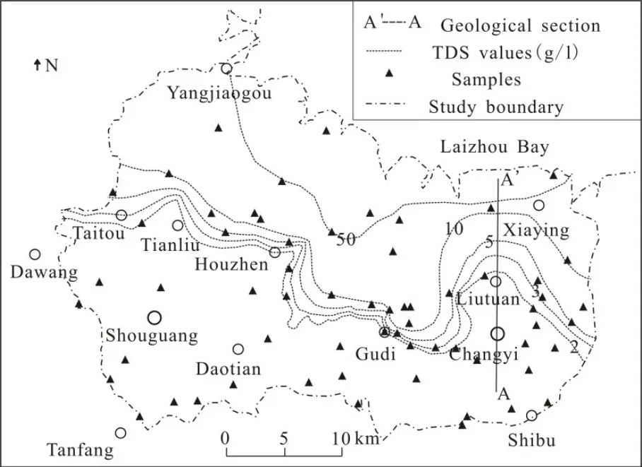
Fig. 1 Location of study area and sampling
2 Water sampling and testing
This research has collected 63 groups of shallow groundwater samples along the flow direction of the groundwater flow. Sampling depth is between 21-80 m and deepens gradually from south to north. See Fig. 1 for sampling locations. In accordance with the operation instructions, before sampling, water was pumped for half an hour to empty water in the wellbore.Water level, temperature, pH and titration HCO3-content were measured on site. The water samples were sent to the laboratory in 500 mL polyethylene bottles for testing. Tianjin Geology and Mineral Resources Testing Center conducted the tests. TDS was measured in gravimetric method; Cl-andwere measured by ion chromatograph, and K+, Ca2+, Na+and Mg2+were measured by atomic absorption spectrometer.
3 Characterization indicators of sea/saltwater intrusion
Hydro-chemical characteristics are the direct indicators of sea/saltwater intrusion. Previous studies often use characterization ion content to analyze the level of sea/saltwater intrusion. Cl-is a regular component of seawater; its properties are stable, and seawater contains much more Cl-than fresh water. TDS shows the salinity level of the water. Its content is distinctly different in salt and fresh water. Therefore, the two elements are common indicators of sea/saltwater intrusion.

Fig. 3 Relationship map between different indicators and Cl-
However, considering that single index analysis may be biased, it is common practice to include other indicators such asrCl-/r. Among them,is a relatively stable ion in sea/saltwater. Its content is higher in seawater than in inland groundwater. Thus it reflects the level of seawater intrusion to some extent.mainly exists in inland freshwater. Seawater is rich in Clbut contains very littleTherefore,rCl-/ris a sensitive indicator of the degree of sea/saltwater intrusion. In addition to the above four indicators, other chemical indicators can also indicate the degrees of sea/saltwater intrusion to various extents. However, their roles vary in different regions. Given that the Cl-distribution in the study area has a clear pattern and has not been contaminated distinctly, this research adopts Clcontent as the main indicator and uses linear regression analysis to decide on other indicators to characterize the sea/saltwater intrusion in this area.
The regression equation is:

In this equation, Ciis the concentration of the targeted ion, CClis Cl-concentration (mg/L), a and b are regression coefficients.
As shown in Fig. 3, TDS, Na+,and rCl-/rHhave relatively high relevance with Cl-.Their R2values are all over 0.90.
4 Distribution features of the content of hydro-chemical indicators
4.1 TDS content distribution
The TDS value of the groundwater increases from south to north and from inland to coast. The TDS isopleth is distributed approximately parallel to the coastline in the study area (Fig. 1 and Fig. 4).Under the influence of groundwater exploitation,hydrogeological conditions, river backwater and other internal factors, isopleth shows a bulge sign toward the coast or piedmont.
4.2 Cl- and content distribution
According to Shoka Lev classification method(Fig. 5), the main hydro-chemical types in this area are: Htype,type,and Cl-type. The distribution of hydro-chemical types has obvious patterns-stripe distributed nearly parallel to the coast from inland to the coast. The chloride type water accounts for nearly 50%,basically covering the areas where the TDS is over 2 g/ L.
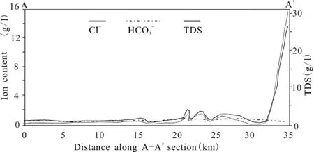
Fig. 4 TDS,Cl- and content along the A-A' section
The content of the Cl-andhas significant concentration differences between southern freshwater area and the northern saltwater area. With the changes of landforms in alluvial plain, alluvial and coast plain and marine depositional plains etc., the content of Cl-andchanges gradually along the salinization path from south to north, with rising Cl-and reducing. The contents of Cl-andare significantly different in salty water and fresh water, consistent with the distribution of TDS. This shows that they are effective characterization indicators for sea/saltwater intrusion, which is consistent with previous research (LIU Hong-wei et al. 2015) (Fig. 4, Fig. 5).

Fig. 5 Hydro-chemical zoning map of groundwater
5 Sea/saltwater intrusion evaluation
5.1 Index grading
At present, the multi-index evaluation method is commonly used in sea/saltwater intrusion evaluation. But there is no unified standard on the grading of indexes. Based on the hydro-chemical features and the sea/saltwater intrusion damage status, referring to previous research results (QIAO Ji-guo et al. 2011; YIN Jian-ping et al. 2011; LI Miao et al. 2012; ZHANG Bin et al. 2013), this paper divides sea/saltwater intrusion into 4 levels.The boundary of salty water and fresh water is between level I and II. The grading of indexes is detailed in Table 1.

Table 1 Indicator values of different sea/saltwater intrusion degrees
5.2 Evaluation method
The intrusion of sea/saltwater into freshwater aquifers is a gradual process. The intrusion boundary is a transition zone rather than a clear line. The fuzzy synthetic evaluation model is based on fuzzy mathematics, using the fuzzy transform principle and maximum degree of membership principle to consider each factor related to the matter under evaluation and evaluate the problem under study comprehensively. Its advantage is that it can quantify factors without clear boundaries,that are hard to quantify, and can establish the sea/saltwater intrusion boundary. Therefore, it is widely used in sea/saltwater intrusion evaluation(YIN Jian-ping et al. 2011; ZHAO Jian, 1998).This research adopts the Fuzzy Synthetic Evaluation Method of ZHAO Jian and YIN Jian-ping (ZHAO Jian,1998) in its evaluation.Firstly, the membership function A of each evaluation factor to 4 sea/saltwater intrusion levels is established. The membership degree of the evaluation index i (i=1, 2, 3, 4, 5) is calculated according to the following the formulas:
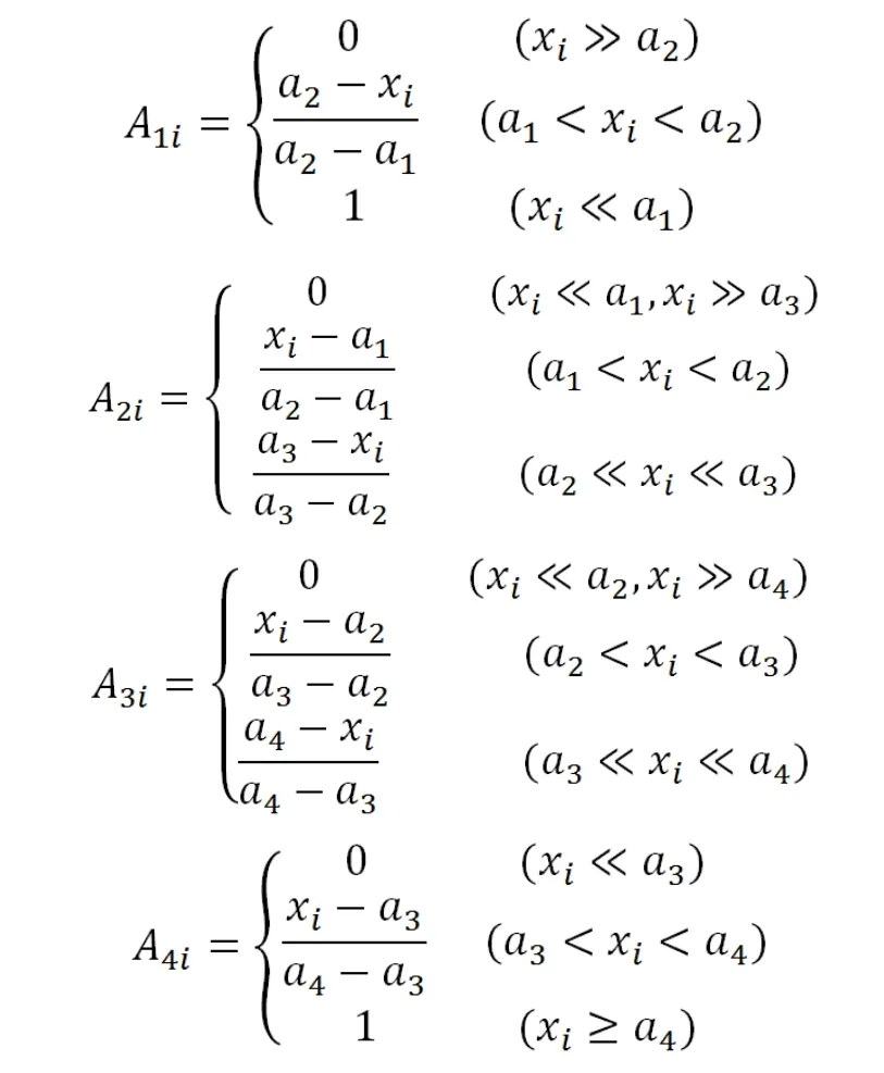
In the above formulas, A1i, A2i, A3iand A4iare the membership level off actor i to 4 levels; xiis the measured value of the evaluation factor i; a1, a2,a3, a4are the representative values of the evaluation factor i to corresponding 4 grades of evaluation index.
Then, the membership level rijof the 5 evaluation indexes to the 4 grades is calculated, to construct the fuzzy evaluation matrix R:

After the completion of the above steps, the weights of the 5 indicators are calculated:
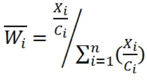
In this way, the 5 indicators of a single evaluation point can form a weight fuzzy matrix of 1×5:

Then, the fuzzy evaluation vector of the evaluation point can be expressed as B=U·R.Normalization can produce the fuzzy evaluation set. Finally, according to the principle of the maximum membership degree of fuzzy mathematics, the maximum value of the evaluation set is taken as the evaluated degree. In order to facilitate the corresponding level of the decision point, the improved final quantization method(YIN Jian-ping et al. 2011; MIAO Qing et al. 2013)is adopted to re-quantify the evaluation set:

In the formula above, M is a self-defined re-quantified index (M=1-4); biis the i column of the evaluation set.
The integer M from 1 to 4 closest to the evaluation value is the sea/saltwater intrusion level of the evaluation point.
5.3 Evaluation result
The evaluation results show that in 63 sets of sampling points, 29 are non-intruded (Grade I),covering an area of around 1 419.33 km2; 10 are slight intrusion (Grade II), covering an area of around 398.57 km2; 9 are moderate intrusion(Class III), covering an area of around 274.49 km2;15 are serious intrusion (Grade IV), covering an area of around 2 370.91 km2(Fig. 6).
5.4 Result analysis
Overall, groundwater in the study area suffers different levels of sea/saltwater intrusion in a gradually increasing trend from south to north. In coastal areas, intrusion has reached a serious level;the central-western boundary is generally consistent with the distribution line of TDS=4-5 g/L; the regional boundary in eastern areas of Changyi-Liutuan town and Weizi town is generally consistent with the distribution line of TDS=2-3 g/L; the moderate intrusion areas are roughly distributed in areas with TDS between 2-3 g/L to 4-5 g/L; the light intrusion areas are roughly distributed in the region of with TDS between 0.8-1 g/L and 2-3 g/L; and the non-invaded areas are mainly distributed in TDS of less than 0.8 to 1 g/L.
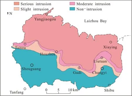
Fig. 6 Sea/saltwater intrusion evaluation
It's worth noting that serious intrusion areas found in this study did not exclude the areas of original salty water and brine, namely the area of the groundwater flow field in the relatively native state. Limited by the positions and quantity of the sampling hole, the sampling points were not evenly distributed, resulting in certain error.Compared to the research results in 2009 (SU Qiao et al. 2009), it is obvious that the sea/saltwater intrusion area in the study area has a trend of increasing, especially the southeast of Houzhen town and east of Changyi. However, as two studies chose different indexes and boundaries, though the same evaluation method was adopted, the area of the sea/saltwater intrusion could not be identified quantitatively.
6 Treatment measures of sea/saltwater intrusion
Sea/saltwater intrusion in Laizhou Bay is mainly caused by human activities and the change of the natural environment (accumulation of native saltwater) (MIAO Qing et al. 2013). Specifically,the excessive exploitation of the fresh groundwater is the main cause of sea/saltwater intrusion and the main factor of the arched interface of southward sea/saltwater intrusion (CGS. 2015). According to the analysis of the current water structure,hydrogeological conditions and precipitation characteristics, the area should take the combination of ecological control and administrative management measures, as well as effective engineering and technical measures if the costs allow. Specific recommendations are as follows:
(1) Optimize the water structure, innovate the water-saving technique. Strengthen the administrative measures to allocate surface and groundwater in a unified way, and reduce the exploitation of fresh groundwater; innovate water-saving irrigation technique and actively introduce the foreign water in large-scale vegetable and crops planting areas like Shouguang and Changyi.
(2) Build ecological protection zone with vegetation of high saline and alkali endurance. In the coastal areas, especially wetlands, plant salt-tolerant vegetation to reduce the area of the hardened land, increase the infiltration recharge in atmospheric precipitation, and form the vegetation ecological protection zone.
(3) Increase rain reserve to recharge the groundwater. Build the simple rain collection projects, collect the rain in the rainy season and recharge the groundwater in the piedmont or near-river areas with coarse particle.
(4) Build the underground reservoir (Werner A D et al. 2013). Build the underground reservoir and dam in coastal areas; use the plain reservoir in Hanting and Binhai development zone to cut off the sea/saltwater intrusion.
(5) Build sea/saltwater intrusion detection and warning system. Use technologies such as remote sensing, airborne geophysical prospecting, ground geophysical prospecting and groundwater stratified monitoring to construct the sea/saltwater intrusion monitoring system, and use numerical simulation(Beaujean J et al. 2014; Sebben M L et al. 2015)and geological information technologies to build the forecast and alert platform of sea/saltwater intrusion.
7 Conclusions
(1) At present, the sea/saltwater intrusion in Laizhou Bay is serious. The serious intrusion area(including original saltwater area) has reached 53.12% of the whole study area; the moderate intrusion area is 6.15%, the slight intrusion area 8.93%, and the non-intrusion area 31.80%.
(2) The distribution of the sea/saltwater in the area has some patterns. On the whole, it gradually diminishes from coastal to inland area; the intrusion in central area is more serious, while the areas in the east and west are relatively light.
(3) The current water usage model is obvious restricted by the economic structure. Ecological,administrative, technical and engineering measures should be applied in a balanced way if economic costs allow.
Acknowledgments
This study was supported by the WATER4COASTS project of Sino-Euro Water Platform, “Comparative Studies of Underground Water Management in the Coastal Areas in Southeast Asia” (ADB-RETA 6498) of the Water Fun of Asian Development Bank, and “Geological Environment Survey and Evaluation in Laizhou Bay” of the Geological Survey of China(CGS-12120113003800).
杂志排行
地下水科学与工程(英文版)的其它文章
- Characteristics analysis and model prediction of sea-salt water intrusion in lower reaches of the Weihe River,Shandong Province, China
- Distribution characteristics of tritium in the soil in Beishan area of Gansu Province
- Evaluation of the water resources carrying capacity of Shandong peninsula, China
- Study on ecological and economic effects of land and water resources allocation in Sanjiang Plain
- Research on Pisha-sandstone's anti-erodibility based on grey multi-level comprehensive evaluation method
- Geological environment impact analysis of a landfill by the Yangtze River
