Geological environment impact analysis of a landfill by the Yangtze River
2016-12-12WUJianqiangWUXiayi
WU Jian-qiang, WU Xia-yi
1Geological Survey Institute of Jiangsu Province, Nanjing 210049, China.
2Key Laboratory of Earth Fissures Geological Disaster, MLR, Nanjing 210049, China.
Abstract: In order to assess the geological environment impact of a city landfill by the Yangtze River, soils from different depths in the dumpsite were sampled and analyzed. It was found that pollutants content at the site was distinctly higher than that in nearby environments. The content of heavy metals, such as Cd, Hg, As, Pb and Cu, reduces as depth increases; the content of elements F, Cl and N is the contrary. Pollutants migration driven by underground water flow was analyzed, considering the hydro-geological conditions of the site. It is believed that, due to leaching after rainfall infiltration, pollutants in the garbage layer migrates deeper,the cohesive soil in the underlying surface prevents them from spreading to the deeper aquifer;additionally, the high pressure tolerance of the deep groundwater is a key factor in preventing pollutants from entering the aquifer. Furthermore, human control has reduced the annual fluctuation range of water level in nearby rivers, weakening the hydrodynamic relations with phreatic water, and thus reducing the spreading of pollutants to nearby surface waters.
Keywords: Groundwater; Dumpsite; Pollutants migration; Geological environment
Introduction
Landfill has always been a main approach of waste disposal in cities (WANG Lin-qing et al.2015). The state has strict requirements on environment control. However, at the time when dumpsites were first built, technical regulations were rare and environmental protection was weak(FENG Ya-bin and CHEN Quan, 2000; CAO Jian-jun et al. 2004). For historical reasons, a riverside city chose to build the landfill site at the river floodplain, causing many pollution concerns to the surrounding environment and underground water. The site has been running for over 30 years and its capacity is reaching saturation. But its environmental impacts have remained unstudied.Usually, at river floodplains, the surface sediments are usually loose sandy soil, which has good water permeability; the phreatic water is shallow; and the connection between underground and surface water is close. Such hydro-geological conditions facilitate the spreading of pollutants in the groundwater system (WANG Guang-hua, 1999).Once the groundwater is polluted, driven by certain hydro-geological forces, it will affect surface water and in turn threaten the water safety of cities relying on the Yangtze River. Therefore, it is necessary to investigate into the pollution of said dumpsite and analyze its geological environmental impacts. The study will also be of value to cities and regions in similar positions.
1 Geological environment overview
1.1 Geological environment
Fig. 1 shows the location of the dumpsite in this study. To its south is urban area; to its north are distributaries of the Yangtze River. It is oval-shaped, taking up an area 320 000 m2. It stands fully on a natural floodplain, not compliant with relevant standards. After over three decades of landfill, the average thickness of dump layer has reached around 5 m thicker in the center and thinner on the rim. In the past ten years, with the social and economic development, the surrounding area is increasingly urbanized; and communities are increasing. In response to the requirements of the latest urban planning, city administrators renovated riverside areas, removing, cleaning and covering old dumpsites and planting vegetation to improve the environment. The site has been turned into a park. However, the potential environment safety issues have not been fully resolved.
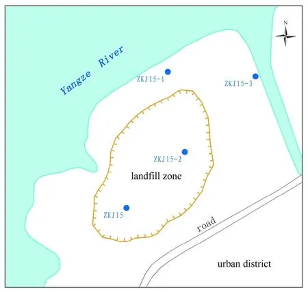
Fig.1 Location of the landfill
1.2 Hydro-geological conditions
The site was originally a floodplain of the Yangtze River, low and flat terrain, with an altitude of about 4-5 m. After land filling, the ground rose and the highest altitude is around 8 m.As this area is a tideway, vulnerable to tides, the water level fluctuates between 3.6-4.2 m. The highest flood- season water level was 6.69 m. To protect the site, anti-flood banks have been built along the river. Five years ago, the city government initiated the riverside scenic belt project, and separated the inland river from the Yangtze River with check gates on the distributaries connected to the Yangtze River.Since then, the water level of the distributary north of the site has been stable, around 3 m.
Due to alleviation of the Yangtze River, the loose shallow sediments of this area are mainly sandy soil. The lithology is hierarchical. From top to bottom, there are three layers (see Fig. 2): from the surface to 15 m under earth is silt clay, constituting the uneven underlying surface of dumpsite with poor water permeability; below 15 m under earth is saturated aquifer, whose lithology is a typical river-binary sedimentary structure: the upper part is silty sand, about 30 m thick, its thickness increasing from south to north; the lower part is medium-coarse sand, about 30 m thick,based on tuff. The aquifer has good water permeability. On-site tests show that the osmotic coefficient K=4.1 m/d, the groundwater level elevation fluctuates between 3 to 4 m, 7 m higher than water resisting roof-rendering it good pressure-tolerance. Driven by the crustal movement of Indo-Chinese and Yanshan Epoch, the bedrock surface of this area is uneven, rising towards the south and above the surface. The bedrock of southern bank of the Yangtze River is mainly limestone and magmatite, developed by karst and structure fissure, and is an important channel of underground water recharge by surface water.
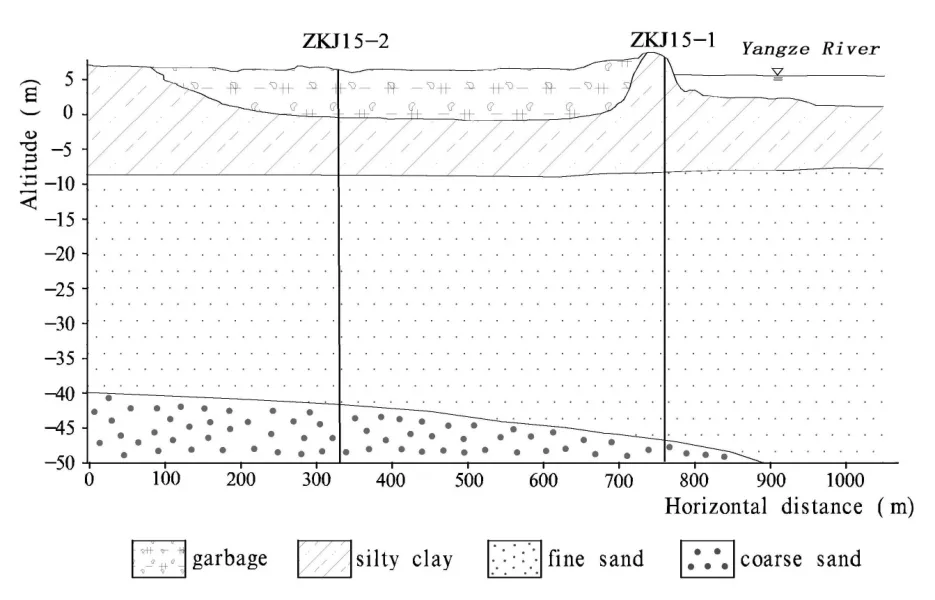
Fig. 2 Hydro-geological section
2 Investigation and testing method
In order to ascertain the potential causes of environment pollution in the geological conditions of the site, multiple measures were adopted,including field investigation, misering, hydrological observation and testing of water and soil samples.
2.1 Soil sampling
Misering sampling was conducted at the original site of the landfill (see location of hole ZKJ15 in Fig. 2) to obtain information concerning the types and intensity of pollutants in the garbage layer and underlying surface. The average sampling interval was set to be 1 m, but it was adjusted in the practice due to the physical properties of the disclosed sediments. Based on the collected soil samples, heavy metal elements such as Cd, Hg, As and Pb and life pollution elements such as N, P and S were tested for content levels.
2.2 Water sampling
Groundwater is an important component of geological environment. A sign of direct damage by the landfill to the geological environment is the diffusion of toxic and harmful substances in garbage layer to the groundwater system, which results in large groundwater pollution. This is one of focuses of geological environment study. Deep geological environments are relatively closed.Once destroyed, the recovery period will be very long, and the restoration costs will be extremely high (LI Chun, 2001; ZHAO Yong-sheng, 2012).This study collected the groundwater samples from the original landfill site and from the upper and lower reaches of same aquifer system. The Yangtze River near the landfill was also sampled for comparative analysis, so as to evaluate the impacts of the pollution on adjacent environment.
2.3 Groundwater level observation
In order to understand the dynamic groundwater level near the landfill, an one-year observation was designed. The observation holes are shown as ZKJ15, ZKJ15-1, ZKJ15-2, ZKJ15-3 in Fig. 1. On-site and off-site was a controlled variable.
The analysis of the underground water level at multiple points across one year is helpful to understanding the dynamic conditions of the groundwater, so as to describe the groundwater flow field, and support the judgment of the migration of pollutants deep underearth.

Fig. 3 Curve of pollutant concentration levels to depth
3 Pollution characteristics analysis
3.1 Soil environment
Through the analysis of samples from sediments of different depths, it is found that there is a significantly high concentration of pollutants in the garbage layer near surface, bordering at the bottom of the garbage layer (about 7 m deep); the geological environment of deeper parts is relatively intact, and the impacts of pollution from upper parts remain unclear. As is shown in Fig. 3,the content of Cd, Hg, As, Pb, Cu, Zn, Mo and Sb in the garbage layer is irregular. Their concentration is several times higher than the level of background soil (the average concentration level in deep silty clay). As the depth increases, the concentration deceases. The concentration of elements F, Cl, N, P and S is significantly higher than that in the deep parts. But the highest concentration of F, CI and N is found at the bottom of the garbage layer while the concentration in the shallow parts is relatively low.
The highest concentration of P and S is found in the shallow parts of the garbage layer; as depth increases, the level of concentration rises, and stabilizes below 8 m underearth.
Test results show that the whole stratum is in slightly alkaline and the PH level is only lower at 7 m deep (Table 1). It is also found that the concentration of Cr in the garbage layer at different depths is relatively stable, different from the vertical patterns of other elements.
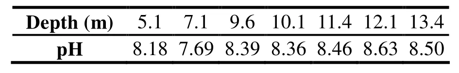
Table 1 PH values of soil at different depths
3.2 Groundwater environment
The city is in subtropical monsoon climate zone. The annual rainfall is about 1 200 mm, and mostly concentrated in July and August. The groundwater level is affected by the rainfall significantly. The fluctuations of groundwater level in four holes near the landfill (Fig. 1) is shown in Fig. 4. The lowest groundwater level of the year is in January to February, at an elevation of 2 m; the highest is in August, about 4 m. The water level fluctuations are consistent with the annual rainfall.

Fig. 4 Fluctuations of groundwater level
The local underground water flow field is also affected by topography. Inland groundwater level far from the river is relatively higher than that near the river. This difference exists across the year. For instance, the water level of ZKJ15 hole is 1 meter higher than that of surrounding holes; this is more significant in dry seasons-the estimated hydraulic gradient is up to 1/1 000. It is speculated that the deep confined groundwater in river valley areas of the Yangtze River is recharged by atmospheric precipitation infiltration. The recharge area should be located in valley area and the geomorphic unit of higher elevations. Within the aquifer, there is a lateral runoff movement from the inland to river valley.
Regular indicator tests of groundwater quality shows that most indicators meet the class III water quality requirements in groundwater quality standards (GB/T14848-93), except the levels of ammonia nitrogen and iron. The results of the comparative analysis of the water quality of the site and the upper and lower reaches are shown in Table 2 (partial indicators). Due to the specific hydrological and geochemical background, the iron content of the groundwater in the middle and lower reaches of the Yangtze River is generally high (ZENG Zhao-hua, 1994; ZENG Zhao-hua,1997); it is hardly indicative to the environment pollution. Therefore, ammonia nitrogen is taken as the main indicator for evaluating the groundwater pollution. The comparative analysis of samples from the underground water of the site, the same layer of upper and lower reaches, and the section of the Yangtze River in the city indicate that the ammonia nitrogen content far exceeds the standard level; the measured levels are mostly in the range of 5-7 mg/L, about 30 times beyond the environmental standards. Chemical oxygen consumption is another key pollution indicator. Though there is no specific standard, the measured values are mostly between 4-7, twice higher than the level of surface water-indicating that the deep groundwater along the Yangtze River is slightly polluted.

Table 2 Water quality analysis (mg/L)
3.3 Environment impacts analysis
3.3.1 Pollution spreading in the garbage layer
After the landfill, the garbage usually undergoes organic acidification, methane fermentation and maturity. The acidification helps metal elements to enter leachate in a free state, and enhances their mobility (LIU Hui-hu et al. 2007).But the process needs to be carried out under the reduction environment. As the landfill was not professionally designed for closed operation, it has been exposed in an open environment for a long time, the garbage acidification is not complete or thorough. This can be verified by the aforementioned mild alkaline soil environment testing.Despite 30 years of landfill, currently, the heavy metal concentration is still the highest concentration in the garbage layer and has weak ion migration ability. The even distribution of Cr in the samples indicates its irrelevance to the landfill-it is a result of natural environment. It is found, from the relationship between the concentration of pollutants in the garbage layer and depth, that the heavy metals migrates lowly deeper through leaching, due to the rainfall infiltration. Meanwhile,it should be noted that in a certain range at the bottom of the garbage layer, phreatic water pressure and confined water pressure reach a balance; the transfusion is no longer the main form of pollution diffusion, and the migration of pollutants is blocked. The pollutants concentration at the bottom of the garbage layer is higher than in the natural environment, indicating that the leachate has affected the soil of underlying surface;as time goes by, the heavy metal content in the underlying surface continues to rise. Moreover, the content of F, Cl and N is most concentrated at the bottom of the garbage layer, indicating their priority in migrating out of the garbage layer towards the surrounding and deeper parts. The causes of different distribution of pollution indicators are: First, the soil has a stronger attraction to cationic than to anionic; second,element S and P mainly exist in the forms ofandin oxidized environment-their ion clusters have large radii and relatively poor migration ability (QIAN Hui et al. 2012). Due to the fluctuation of groundwater level, the balance point of the hydraulic difference in the upper and lower layers is also moving. In order to control the scope of impacts from the landfill pollution and curb the pollutants from spreading to groundwater,the groundwater level should be controlled, and in particular, the confined property of the deep waterheads should be maintained.
3.3.2 Sources of pollution of the confined aquifer
Groundwater runoff is a main driver of pollutant migration, and the main indicator of the source of pollution. The deep groundwater(confined) waterhead in the landfill is higher than the upper confining bed, i.e. due to the hydraulic gradient, the deep groundwater tends to flow or excrete to upward; and it's hard for the pollutants in the garbage layer to migrate to the confined aquifer. According to the analysis of the hydraulic gradient of groundwater and the levels of ammonia nitrogen and organic substances in this area, it is believed that the groundwater pollution is not from the landfill but the groundwater recharge area or areas with roofs. The hilly areas south of the Yangtze River (including the bedrock mountain dew) are densely populated, and have a large number of chemical plant sand plenty of urban and suburban farmlands. The industrial wastewater,agricultural fertilizers and household waste resources of nitrogen and organic waste. Due to its poor soil colloid adsorption ability, NH4+-N constitutes the main part of the pollution (YANG Wen-lan et al. 2010). After leaching by rainfall and surface water, pollutants containing N migrate to the underground aquifer system. After they enter the aquifer system, they continue to migrate laterally along the hydraulic gradient and diffuse in a faceted way.
3.3.3 Landfill's impacts to surface water
The landfill is close to the distributary of the Yangtze River. The site was originally floodplain,where the surface water and the river have natural hydraulic links. Prior to the control of the inland river water level, the surface water level is controlled by tide. Thus the fluctuations across the year is huge. In the flood season, the river recharges the surface water; in dry seasons, the surface water excretes to the rivers. This cyclic hydraulic alternation is the main approach of pollution diffusion into the river. However, the connection between the Yangtze River and the its distributary is now blocked; the river water level near the landfill remains stable around 3 m throughout the year; and the gradient of the surface water level is largely reduced; thus the ability of the pollutants spreading to the river has reduced,too.
4 Conclusions and suggestions
(1) The concentration levels of the heavy metal elements and F, CI, N, S and P are significantly high in the landfill. At present, most pollution components are concentrated in the shallow parts of the garbage layer and their concentration level decreases as depth increases. But F, CI and N have demonstrated higher mobility-they are found most concentrated at the bottom of the garbage layer.Deep confined groundwater pollution mainly consists of ammonia nitrogen, and its organic substance content is higher than that of the surface water. But it is found to be irrelevant to the landfill.The impact of the landfill goes only as deep as to the upper clay bed of the underlying surface so far,and it has yet significantly affected deeper geological environment.
(2) Since the break-off of the hydraulic connection between the distributary north of the landfill and the Yangtze River, the surface water level has remained relatively stable. Its periodically alternating hydraulic correlation with the surface water has largely reduced. Therefore,the pollution risk of the surface water from the landfill has decreased.
(3) The pressure bearing of the deep groundwater is favorable to curb the waste from spreading downwards. In the future, the hydrodynamic conditions should be maintained to form a negative waterhead relative to the deep confined water by controlling to reduce the level of the surface water.Meanwhile, the surface drainage system should be improved, in order to reduce the leaching of the rainfall to the garbage layer.
(4) Due to the special location of the landfillclose to communities and being part of the urban riverside scenery belt, its environmental safety is of great significance. Although the landfill pollution is controllable at current stage, it is advisable to strengthen monitoring, set up risk prevention and warning, and conduct pollution treatment when necessary, so as to reduce the burden on the environment and encourage the landfill's harmless transformation.
Acknowledgements
This study is supported by the geological survey found project of Jiangsu Province (2011)425. Mr. PAN Yong-min's drawing work contribution to this paper is appreciated.
杂志排行
地下水科学与工程(英文版)的其它文章
- Characteristics analysis and model prediction of sea-salt water intrusion in lower reaches of the Weihe River,Shandong Province, China
- Features and evaluation of sea/saltwater intrusion in southern Laizhou Bay
- Distribution characteristics of tritium in the soil in Beishan area of Gansu Province
- Evaluation of the water resources carrying capacity of Shandong peninsula, China
- Study on ecological and economic effects of land and water resources allocation in Sanjiang Plain
- Research on Pisha-sandstone's anti-erodibility based on grey multi-level comprehensive evaluation method