Analysis of the negative effects of groundwater exploitation on geological environment in Asia
2015-12-12ZHANGJiankangWENXueruGAOYunYUEChenYIQing
ZHANG Jian-kang, WEN Xue-ru, GAO Yun, YUE Chen, YI Qing
Institute of Hydrogeology and Environmental Geology, CAGS, Shijiazhuang 050061, China
Abstract: This paper summarizes the negative effects on geological environment caused by groundwater exploitation and its distribution. There are seven main types of the geological environment negative effects, which are generally as follows: (1) Constant decrease of groundwater level is mainly distributed in China (East Asia), India (South Asia), Tajikistan(Central Asia) and Saudi Arabia (West Asia); (2) land subsidence occurs mainly in eastern plains of East Asia and west Siberian Plain of North Asia; (3) seawater intrusion occurs mainly in China, Japan and South Korea in East Asia, Philippines and Indonesia in Southeast Asia,the Indian coastal areas in South Asia; (4) groundwater level decline caused by groundwater exploitation in oil fields; (5) mining collapse is mainly in 50° to 70° north latitude band; (6) the total area of karst collapse in China of East Asia is as much as 197.05 km2; and (7) ground fracture is mainly distributed in the North China Plain, Fenwei Plain and the Yangtze River Delta. Asia can be divided into 6 zones in terms of the geological environment negative effect caused by groundwater exploitation. According to analysis, with the increasing intensity of human activities, geological environment issues become more and more serious, therefore it is vital to control the human activities within the scope of 5×10⁵ people/km2 to 9.9×10⁵ people/km2 for the effective control of the size of the affected area by geological environment problems.
Keywords: Asia; Groundwater development; Geological environment negative effect and distributed regions; Severity of geological environment problems
Introduction
In the evolution of geological environment,drastic environmental effect of groundwater is brought about by the combination of natural evolution and human activities. Such effect has two sides. On the one hand, groundwater is the fundamental resource for human’s life and social development for it meets the consumption of water in industry, agriculture and human drinking, and in many regions, groundwater development is an important measure to combat drought. On the other hand, with the population expansion and agriculture development, the water demand increases sharply. In may populated regions, the groundwater is developed in a highly intensive way and the exploitation has exceeded the natural water supply, which has led to the dramatic decrease in groundwater quantity and groundwater level and even caused the formation of groundwater depression cone, land subsidence and collapse and water decrease in rivers and lakes which may result in dried-up river ways and lakes.
Since 2010, the groundwater exploitation in Asia is about 680 km3/a, accounting for 30% of the total groundwater exploitation of 2 257 km3/a in Asia,69.3% of the total groundwater exploitation of 982 km3/a worldwide and 17% of the total water exploitation worldwide. The groundwater exploitation in main Asian water consumers including India, China, Pakistan, Iran and Bangladesh accounts for two thirds of the total groundwater exploitation.In the recent decade, the highest increase in groundwater exploitation worldwide is witnessed in India and China (FANG Sheng, 1996; LIN Zuo-ding,2004). According to the statistics, the groundwater exploitation in Asia plays an important role in world groundwater exploitation. In West Asia, due to the insufficient water resource, more than three fourth of the region lacks runoffs, and the annual rainfall is below 200 mm with a very few areas over 600 mm(MA Xiu-qing, 1989). The Southeast Asia is rich in groundwater resource and has a long history of groundwater exploitation but with low exploitation quantity. In North Asia and the part of Russia in Asia,water resource is much richer than that in China, with the average per capita water resources of 2 911.5×10⁹m3, 12 times of that in China, and the Baikal freshwater accounts for 20% of the world freshwater(XING Rong and LI Li, 2010).
A series of geological environment issues have been triggered by the intensive, even excessive groundwater exploitation in Asia. In recent years,such issues even have posed threats to human life.For example, land subsidence lowers the urban drainage and flood control ability, triggering the seawater encroachment in coastal cities which destroys roads, bridges, underground pipelines and constructions, posing enormous threat to safe urban operation. The mining collapse and ground fracture have led to a series of hazards including the building collapsing, farmland destruction, strong drainage of groundwater and dried-up wells in the subsidence areas, causing huge economic losses. Karst collapse has caused huge damages to many fields including transportation, mining, hydropower engineering,military facilities, agriculture and urban construction.Seawater intrusion has led to the deterioration of water quality in coastal areas, which results in the reduction of industrial, agricultural and domestic water, soil ecosystem imbalance and arable land degradation. As a consequence, the industrial and agricultural production is heavily affected, human health is under the threat of harm and finally led to the deterioration of ecological environment.
In 1995, the 26thInternational Association of Hydrogeologists (IAH) is held with the theme of “the influence of human activities on groundwater”. One of the four global professional topics proposed by the speaker was as follows: the area with rapid growth of population is the area where the freshwater resources are insufficient, so the combating with water shortage is becoming one of the global concerns (CHEN Bao-ren, 1996; GUO Meng-zhuo and ZHAO Hui,2005).
In summary, the research on the geological environment negative effect of groundwater development and its special distribution, together with the investigation of the key factors closely related to the groundwater development and use can provide the statistical basis for the reasonable groundwater development and use proposed for the development strategy by China and its neighboring areas, and the materials for the global climate change study so as to support the macroeconomic policy planning and land improvement for China and its neighboring nations.
1 The distribution characteristics of geological environment negative effect of groundwater development
According to the current regional materials and based on the macro analysis, the geological environment negative effect of the irrational groundwater exploitation in Asia can be categorized into 7 types, namely, constant decrease of regional groundwater level, land subsidence, karst collapse,ground fracture, seawater intrusion, decrease of groundwater level in oil field and collapse in mining area (Fig. 1).
1.1 Constant decrease of regional groundwater level
Constant decrease of regional groundwater level generally refers to that the groundwater depression cone cannot be recovered (drawdown rate>1.0 m/a)during one hydrological year to many hydrologic cycles, which renders the supply of industrial,agricultural and domestic water difficult and exerts server impact on ecosystem.
Constant decrease of regional groundwater level is commonly seen in countries including China (East Asia), India (South Asia), Tajikistan (Central Asia)and Saudi Arabia (West Asia) or in intermountain basin and river delta in terms of geomorphic type where the groundwater demand is huge, population is large and industry is developed.
As in 2002, there were more than 100 groundwater depression cones caused by overexploitation in countries, China in particular, in East Asia, which even makes the groundwater level difficult to recover and the soil layer compressed, forming a large area of land subsidence. In addition to the groundwater depression cones formed by exploitation of shallow water, the more serious issue is the formation of such cones caused by the exploitation of the deep confined groundwater, and some provinces even have combined groundwater depression cones resulted from the exploitation of shallow groundwater and confined groundwater. The aforesaid influences have triggered a series of ecosystem issues. Besides China,Korea and Japan also have witnessed the overexploitation of groundwater. The groundwater level has decreased by 10 to 50 m due to the groundwater exploitation in some cities in Korea(ZHONG Hua-ping, 2011).
The domestic water in more than 400 cities in South Asia is supplied by groundwater, among which the groundwater in coastal cities has been overexploited, making the groundwater level keep declining. India in South Asia has one tenth of the world arable land with an area of 0.16×10⁹hm2, so water there is mainly used for irrigation which largely depends on water from Ganges River. Groundwater used for irrigation accounts for 36.6% of the total irrigation water amount in India. The groundwater level in islands of India and western India has dropped to the depth that manpower pumping equipment cannot reach. In north Gujarat, the water depth of pumping wells was only 10 to 15 m thirty years ago but now is 400 to 450 m (FANG Sheng,1996).
Central Asia is located in the world’s largest continent-inner part of the Eurasian continent, too far for the water vapor over the ocean to reach, so the climate there is characterized by hot summer and cold winter, scarce precipitation and perennial drought(CHENG Yan-pei et al. 2010), resulting in the lack of groundwater recharge. The surface water is scarce and the vast majority of the water is salt water, so residents there mainly rely on groundwater to maintain life, which led to the groundwater overexploitation.
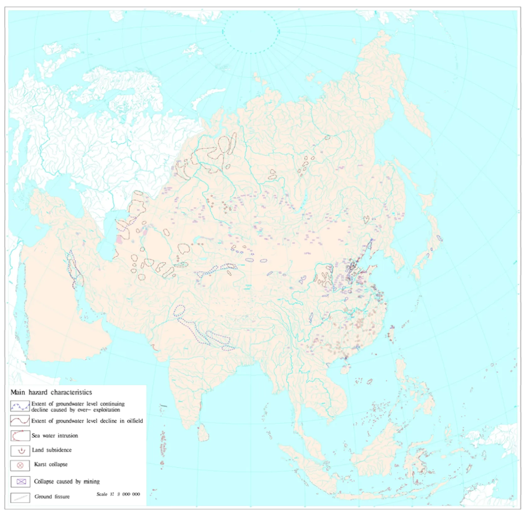
Fig. 1 Distribution of geological environment negative effect of groundwater overexploitation in Asia
The number of irrigation wells in West Asia,Southeast Asian subcontinent and Pakistan in Central Asia increased by 1 million per year. Consequently the groundwater exploitation has exceeded its annual recharge in a large area which is still growing (MA Xiu-qing, 1989). Groundwater overexploitation can be found in China’s 24 provinces (autonomous regions and municipalities), among which Hebei Province has the largest area of groundwater overexploitation, amounting to 66 973 km2,accounting for 91.6% of the province’s plain area(ZHANG Zhao-ji, 2009).
1.2 Land subsidence
Most of the land subsidence is caused by the decreased pore water pressure, increased effective stress and compacted soil layer resulting from groundwater exploitation, and a small portion of the land subsidence is because of the secondary consolidation. This paper discusses the former.
Large-scale land subsidence occurred mainly in eastern plains of East Asia and west Siberian Plain of North Asia. With China as the representative of East Asia, the land subsidence was first discovered three decades ago in the North China Plain, and it has settled more than 2 m accumulatively. In big cities in the Yangtze River Basin, such as in Shanghai, the maximum land subsidence is 2.63 m (SHENG Hai-yang et al. 2006; LIU Chang-li et al. 2011). Land subsidence destructs buildings and production facilities and is not conductive to construction and resources development for more funds will be needed and the productivity is restricted. Seawater encroachment often happens alongside with the occurrence of the land subsidence. Due to the lack of information of other regions outside China, the research should be improved.
1.3 Karst collapse
In accordance with the causes, collapses triggered by human activities fall into the following types:collapse caused by tunnel drainage or water bursting,collapse caused by the karst groundwater extraction,collapse caused by reservoir water storage or diversion, and collapse caused by shock or loading.This paper focuses on the collapse caused by the karst groundwater extraction and that caused by reservoir water storage or diversion. Karst collapse is controlled by lithology, structure, karst conditions,nature of the overlying Quaternary loose layer,thickness and hydrodynamic conditions, but the root cause for the karst collapse is the underground loose soil formed by the over-pumping or over-draining of the karst groundwater by human beings.
Due to data limitations, the study region of this research is only in China in East Asia. According to the geological data of the geographical environment in major cities nationwide, karst is distributed in a wide range in China with the most developed ones in Guilin, Hunan, Sichuan, Jiangxi, Yunnan and Hubei,where the number of the places having karst collapse is more than 800 and the total number of the collapse pits is over 30 000, posing a serious threat to buildings and lifeline engineering. According to the statistics of the assessment on the environmental geological survey of major cities nationwide in 2011,the total area influenced by karst collapse is 197.05 km2, causing direct economic losses of RMB 63 759.24×10⁴yuan, and indirect losses of RMB 423 079.6×10⁴yuan (SHENG Hai-yang et al. 2006;LIU Chang-li et al. 2011).
1.4 Ground fracture
Ground fracture is a macroscopic surface damage phenomena where a crack can be seen with a certain length and width caused by natural factors such as surface rock and soil (tectonic activity, the effect of water, etc.) or human activities (pumping, irrigation,excavation, etc.), tectonic activity and groundwater overexploitation are major factors that aggravate the ground fracture.
Due to the lack of some materials, in this paper we only discuss the condition in China in East Asia.Ground fracture in China is mainly distributed in the North China Plain, the Fenwei Plain and the Yangtze River Delta, with a total number of 828, causing direct economic losses in the amount of RMB 4 786.241×10⁴and indirect economic losses in the amount of RMB 2.991×10⁸yuan (LIU Chang-li et al.2011).
1.5 Seawater intrusion
When the natural dynamic balance between groundwater and coastal waters loses, the interface between seawater and fresh water approaches to the land or seawater inrush into fresh water aquifers in the form of wedge, and then the seawater intrusion appears. The rapid development of urban enterprises in major port cities in coastal areas accelerates the population growth, so the demand of groundwater is increasing as well. Due to the groundwater overexploitation in these areas, coastal zones in many cities have witnessed the intrusion of seawater into the freshwater aquifers, which seriously endangers people’s life, production and construction,threatening the urban groundwater exploitation and directly affecting the development of the coastal cities. Large-scale salinization has been seen in the seawater intrusion areas, resulting in the reduction of the irrigated areas. In addition, the health of residents is also affected because of drinking the groundwater which is intruded by seawater.
Seawater intrusion occurred mainly in China,Japan and South Korea in East Asia, Philippines and Indonesia in Southeast Asia, the Indian coastal areas in South Asia (GUO Zhan-rong et al. 2003).
1.6 Groundwater level decline in oil field
Oil exploration needs to consume a large amount of water, in the case of surface water shortage people have to resort to groundwater exploitation.Petrochemicals industry has contributed to the urbanization of some cities, but after that, the water demand increased. After decades’ oil exploitation, the decrease of groundwater level in large scale has been formed. Take Daqing, a large industrial city in China of East Asia as an example, after the oil exploitation in Daqing oil field for thirty years, a wide range of groundwater depression cones have been formed.What’s more, Liaohe Oilfield has suffered issues such as Neogene underground freshwater depression cones and saltwater intrusion.
From the distribution in latitude, Asian oilfields are mainly in 50° to 70° north latitude band, including the famous North Sea Oilfield, the Russian Volga and Siberian Oilfields. The groundwater level decline in these large oilfields is extremely serious(QIN Yan-jun et al. 2001; GUO Hua-ming et al.2001).
1.7 Mining collapse
Water resources are the key factors for the development scale of coal base and industrial development. Mining and the water conservancy construction supported by it have brought about economic benefits, but at the same time, the ecosystem is damaged, causing a series of water environmental problems and exacerbating the water shortage contradiction. For mining requires the drainage of groundwater, it leads to the decline of groundwater level. At the latter stage of mining,obvious ground deformation shows up. In server cases, collapse occurs.
Mining collapse is mainly distributed in mid-latitude strip, which is a necessary condition to coal formation: warm and humid climate that is favorable to terrestrial plants growth; a anoxic and reducing environment provided by swamps; continued settling basin or lowland that is convenient for the accumulation of plant debris and inorganic sediment; and mostly importantly, only large-scale development of terrestrial plants can provide a prerequisite for coal formation (SONG Xian-fang et al. 2012).
The Siberian continent in North Asia, the ancient Chinese mainland in East Asia and the five Stans in Central Asia are all located in the mid-latitudes, and the warm and humid climate at that time provide favorable conditions for the formation of large-scale coal fields in the lowland in front of maintains or in the basins or swamps in coastal areas and inland.Therefore, the groundwater drainage led by the mining collapse in mid-latitude Asia is the most serious.
2 Zoning of geological environment negative effect of groundwater exploitation
2.1 Principles of zoning
The ecological and environmental problems caused by groundwater overexploitation do not exist only in one form but in various forms at the same time in the same area. Based on the negative effects of geological environment triggered by groundwater exploitation and according to the vital standard for zoning in terms of topography and water-bearing rocks type, the primary and secondary classifications are carried out.
Firstly, according to the topography, typical effect and the distribution of the geological environment negative effect caused by groundwater exploitation analyzed above, the primary classification is as follows: The hazard zone resulted from groundwater exploitation in plain basins, mutational hazard effect zone caused by local exploitation of karst groundwater, mutational hazard effect zone caused by groundwater drainage in mining area, unobvious hazard effect zone caused by disperse exploitation of groundwater in hilly areas and normal effect zone caused by sparse exploitation of groundwater.
Secondly, referring to the distribution of geological environment negative effects caused by overexploitation of groundwater, the hazard zone resulted from groundwater exploitation in plain basins can be divided into 2 categories, namely,extensive slowly varying hazard effect zone caused by intensive exploitation of groundwater in plain basin, and unobvious hazard effect zone caused by normal exploitation of groundwater in plain basin.Therefore there are 6 zones in total, namely,extensive slowly varying hazard effect zone caused by intensive exploitation of groundwater in plain basin, unobvious hazard effect zone caused by normal exploitation of groundwater in plain basin,mutational hazard effect zone caused by local exploitation of karst groundwater, mutational hazard effect zone caused by groundwater drainage in mining area, unobvious hazard effect zone caused by disperse exploitation of groundwater in hilly areas and normal effect zone caused by sparse exploitation of groundwater. The distribution of such zones is shown in Fig. 2.
2.2 Zoning of geological environment negative effect of groundwater exploitation
(1) Extensive slowly varying hazard effect zone caused by intensive exploitation of groundwater in plain basin.
This zone is mainly distributed in Northeast China Plain, the North China Plain, the Tarim Basin, the north basin of Heihe River Basin in Hexi Corridor, the north basin in Shiyang River Basin, the Yangtze River Plain, the coastal areas along the coast of the Korean Peninsula and the coastal areas in eastern Japan, the Indus River Plain and the Ganges Plain of South Asia; and the Mesopotamian plain in West Asia.
Most of this zone is flat and some parts are distributed in undulating mounds and terraces. The type of groundwater is loose sediments micro pore water, and the aquifer is homogeneous isotropic structure. This zone is characterized with multiple geological environment negative effect, having all the seven types of such effect. The order for the effects in terms of area is as follows: Regional constant decrease of groundwater level > land subsidence >groundwater level decline caused by groundwater exploitation in oil fields > mining collapse > ground fracture > seawater intrusion > karst collapse.Therefore, it can be seen that the dominant negative effect in this zone is the regional constant decrease of groundwater level caused by groundwater exploitation.
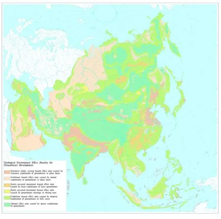
Fig. 2 Distribution of geological environment negative effect caused by groundwater exploitation in Asia
(2) Unobvious hazard effect zone caused by normal exploitation of groundwater in plain basin.
This zone is characterized by undulating terrain with relatively inferior hydrogeological conditions and thinner aquifer compared with the extensive slowly varying hazard effect zone caused by intensive exploitation of groundwater in plain basin, thinner aquifer, and the structure of the aquifer is anisotropic in homogeneity.
This affected zone is mainly distributed in North Asia, Central Asia, West Asia and Southeast Asia,including the Kolyma lowland, North Siberian lowland, and West Siberian Plain in North Asia; the Caspian lowland and Turan Plain in Central Asia;Arab plateau in West Asia; and Indochina in Southeast Asia. From the figure, this zone is largely distributed in the West Siberian Plain, Turan Plain and Arab Plateau, while is distributed in North Asia,East Asia and Southeast Asia in a scattered and sporadic way.
There are four main geological disasters, and the order of them in terms of the area of distribution is as follows: Groundwater level decline caused by groundwater exploitation in oil fields > regional constant decrease of groundwater level caused by groundwater exploitation > mining collapse > ground fracture. Hence it can be seen that the main geological disasters in this zone are groundwater level decline caused by groundwater exploitation in oil fields and regional constant decrease of groundwater level caused by groundwater exploitation.
(3) Mutational hazard effect zone caused by local exploitation of karst groundwater.
The characteristics of this zone are distinct with strong and moderate soluble carbonate. Such zone can be seen in North Asia, East Asia and South Asia,among which a large amount of soluble carbonate can be found in eastern and central Siberian Plateau in North Asia with sporadic distribution in Chersky Mountains; in East Asia, contiguous distribution of soluble rocks can be observed in China’s Yunnan-Guizhou Plateau and southern hills, basins and plains,where the collapsed are gathered due to the well-developed soluble rocks and is the region with most karst collapses and karst disasters; North mountains, plateaus and Huanghuaihai Plain have exposed and hidden karst as well as collapse columns which can lead to collapse; the karst development in Liaodong Peninsula is moderate with relatively more collapses; and exposed and concealed karst can be seen in northeast of South Asia.
(4) Mutational hazard effect zone caused by groundwater drainage in mining area.
This zone is mainly distributed in Central Asia,North Asia and East Asia among north latitude from 30° to 60°, including the north mining area in Kazakhstan hills in Central Asia; the mining area along the north side of Sayan Mountains, the mining area along east side of the Ural Mountains, and the Choibalsan mining areas along the north and south sides of the Stanovoy khrebe in North Asia; the mining areas along the western edge as well as in the intermountain areas between the Sikhote-Alin Mountains and Changbai Mountains in northeast China in East Asia; and the mining areas in mountain areas of North China and Liaodong Peninsula.
(5) Unobvious hazard effect zone caused by disperse exploitation of groundwater in hilly areas.
Except the mutational hazard effect zone caused by groundwater drainage in mining area, the other hills and mountains of Asia basically belong to the unobvious hazard effect zone caused by disperse exploitation of groundwater in hilly areas.
These areas, due to scarce human activity and good ecological environment, are basically undeveloped without overexploitation of groundwater.Therefore groundwater exploitation is distributed in a quite scattered way without obvious harm.
(6) Normal effect zone caused by sparse exploitation of groundwater.
This zone with sporadic groundwater exploitation mainly distributes in the plateau area. Because of low temperature, the plateau is not an ideal habitat for human beings, and the exploitation of groundwater is extremely underdeveloped. For example, the Iranian Plateau in West Asia, the Tibet Plateau, the Mongolian Plateau, the Yunnan-Guizhou Plateau, the Loess Plateau, and the Inner Mongolia Plateau in East Asia, the Central Siberian Plateau in North Asia,the East Siberian Highland, the Kamchatka Peninsula and the South Deccan Plateau in South Asia are all normal affected zones with sporadic groundwater exploitation.
3 Relationship between human activities and geological environment of groundwater exploitation
3.1 Population density and distribution in Asia
With a total amount of more than 3.7 billion,Asian population accounts for about 60.7% of the world. The population in six Asian countries including China, India, Indonesia, Pakistan,Bangladesh and Japan respectively reached hundreds of millions (YUAN Ya-qin and HUANG Xiao-feng,2008).
The statistics for map of population density &distribution in Asia is provided by China Cartographic Publishing House. Fig. 4 shows that population in Asia mainly concentrates in two major regions: The Pacific Rim in east China and south Japan, and India, Bangladesh and surrounding countries in South Asian Sub-continent, while North and Central-North Asia, though has a large area, is sparsely populated. Due to the limited economic development level, urban population in Asia is less than 30%. The large-scale population distribution is in accordance with the intensity of human activities.
3.2 Relationship between population density and geological environment
In order to analyze the relationship between the negative effects of different geological environment and their corresponding population density, what comes first is the collection and classification of different types of geologic hazards. Next, the population density map layers with the scope of constant decrease of regional groundwater level, and land subsidence, karst collapse, ground fracture and saltwater intrusion map layers are respectively analyzed using the method of overlay analysis.Meanwhile the percentage of every type of geologic hazard in different population density areas is produced respectively as demonstrated in Table 1.Later on add up all the proportion of geologic hazards in each area and discover the level of geologic hazards of this area as illustrated in Table 2.
Through analyzing the above table, it can be told that the percentage of the constant decrease of regional groundwater level reduces from: Dense area> common area > relatively dense area > relatively sparse area, with other two areas 0. The percentage of land subsidence reduces from: Dense area > common area > medium area > relatively dense area with other two areas 0. The percentage of karst collapse reduces from: relatively dense area > medium area > dense area>common area with two other areas 0. The percentage of ground fracture reduces from: Dense area > relatively dense area > medium area with three other areas 0. The percentage of saltwater intrusion reduces from: dense area > relatively dense area >relatively sparse area with other three areas 0.
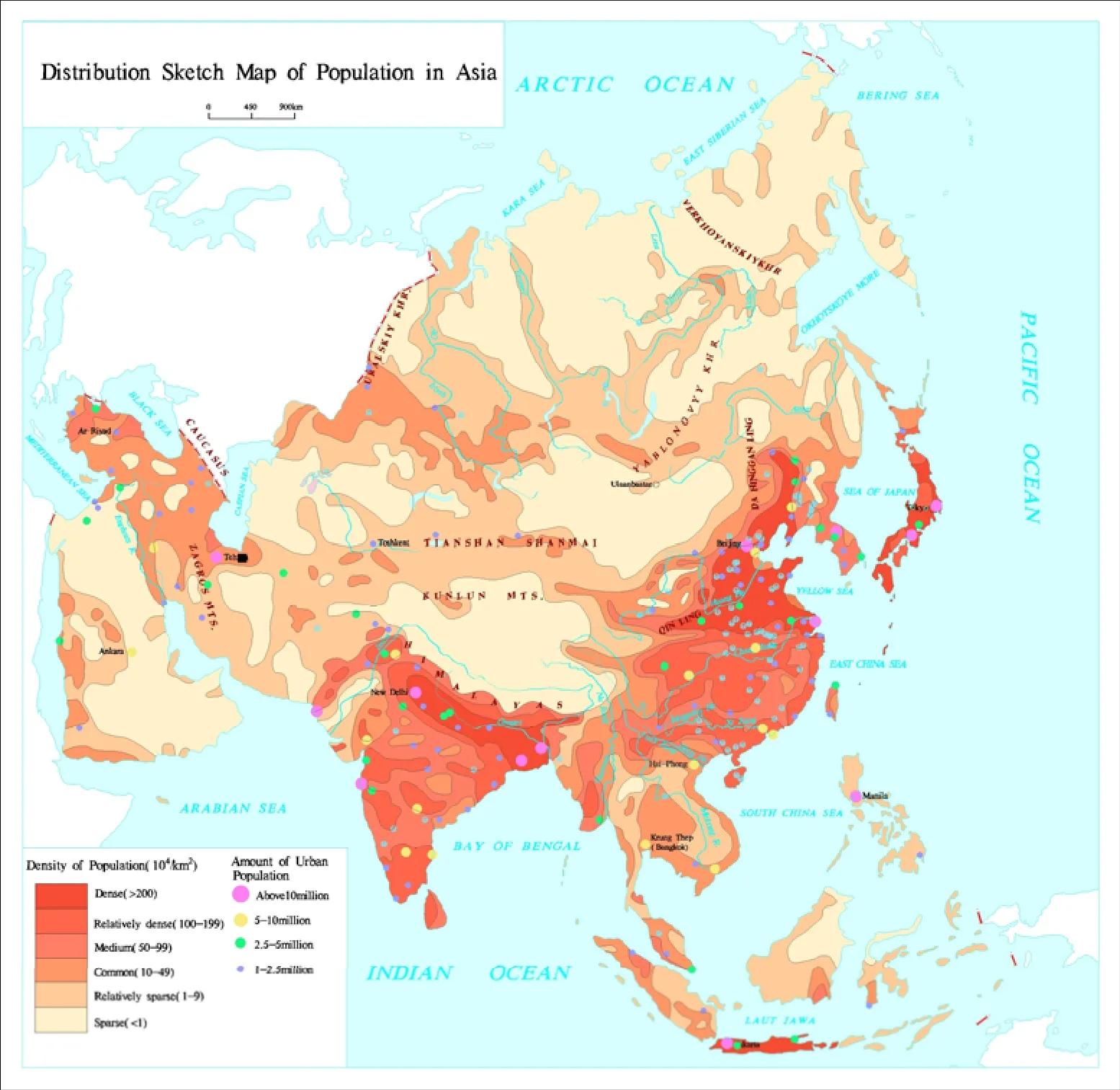
Fig. 3 Population density & distribution in Asia
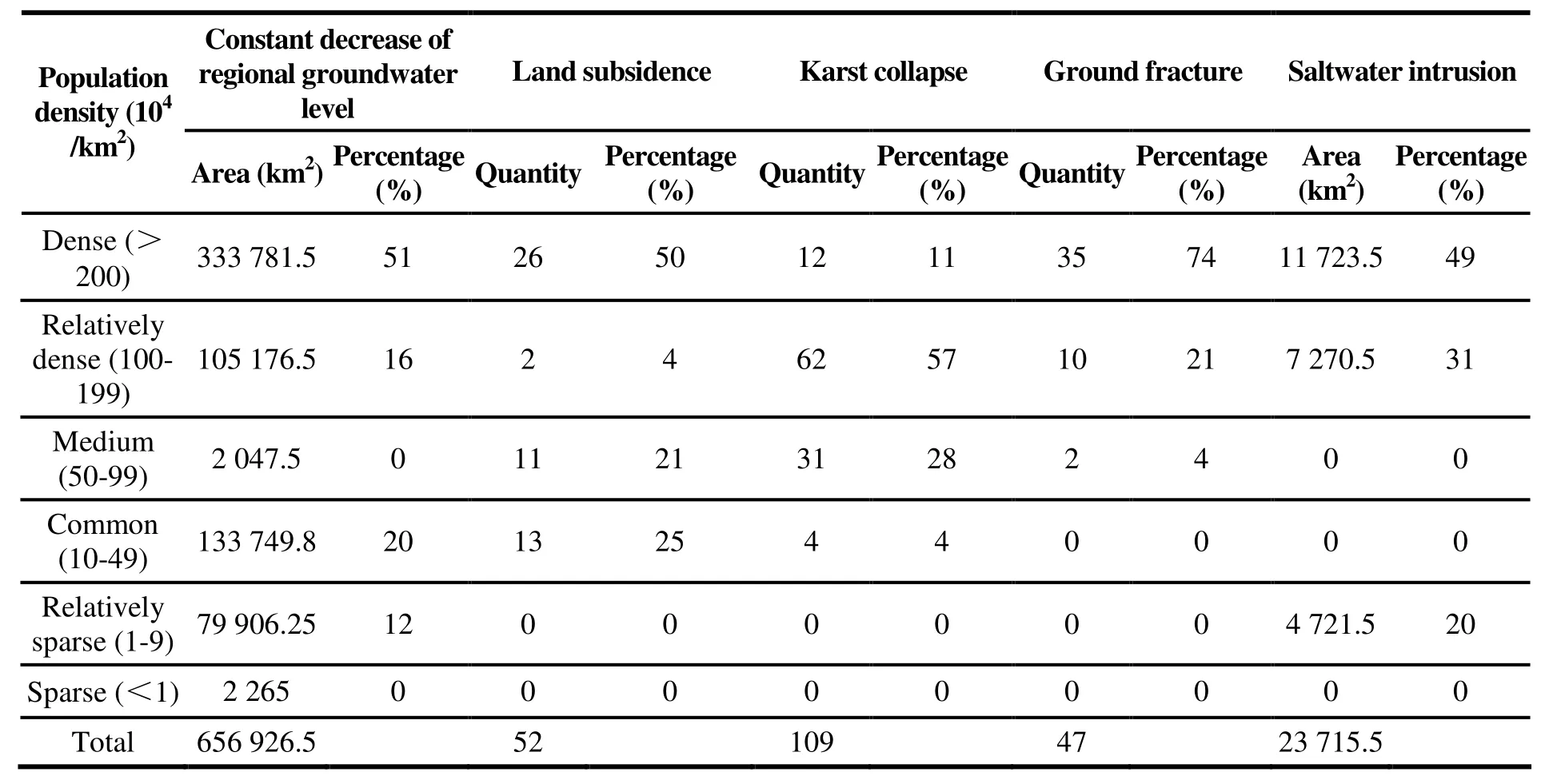
Table 1 The percentage of geological environment problems in different population density areas
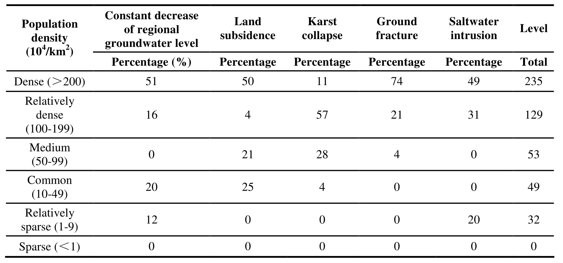
Table 2 The level of geological environment issues
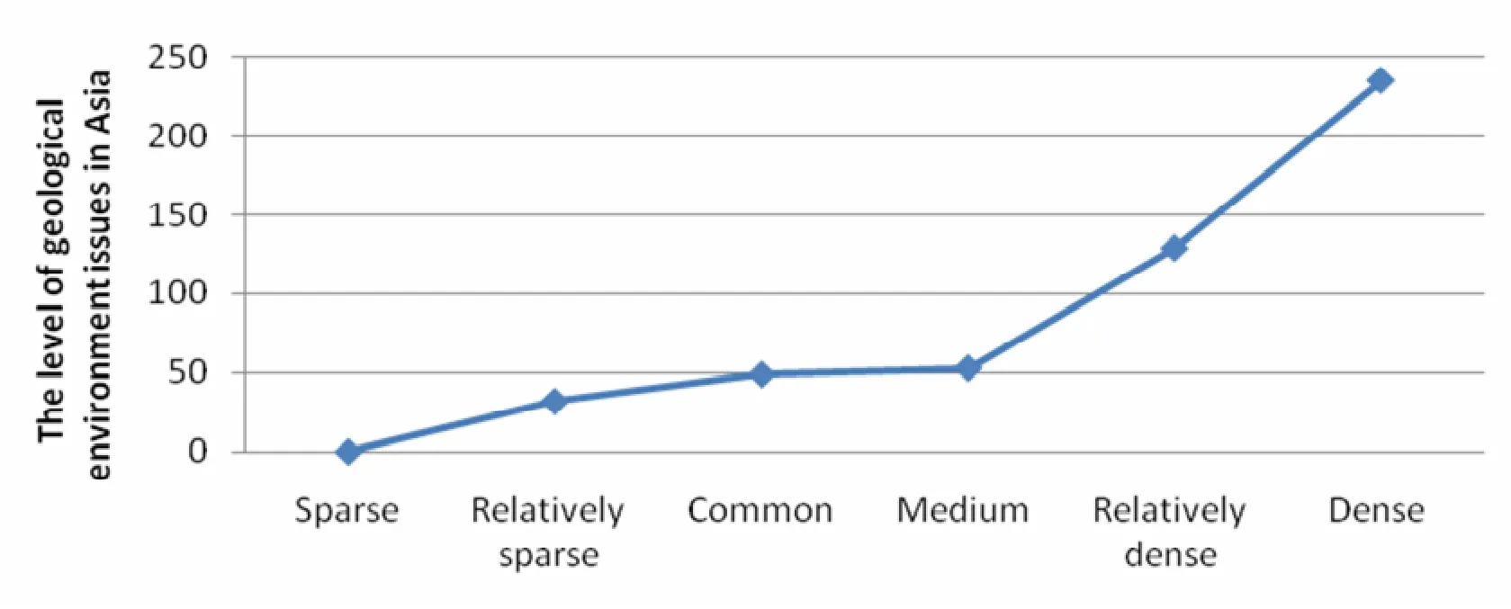
Fig. 4 Population density in Asia
After adding up the percentage of several geological environment problems in areas where the intensity of human activities is different, the level of geological environment problems in each area can be found as shown in Table 2. The more intensive the human activities are, the more severe geological environment problems become. That is to say, the increase rate of geological environment problems speeds up with the growth of population density.When the density of human activities reaches medium (5×10⁵person/km2-9.9×105person/km2),geological environment problems get increasing severe. Therefore, in order to reduce geological environment problems, it is necessary to control the density of human activities in the range of 5×10⁵person/km2-9.9×105person/km2.
4 Conclusions
The irrational exploitation of groundwater in Asia results in seven major negative effects on geological environment: Constant decrease of regional groundwater level, land subsidence, karst collapse,ground fracture, saltwater intrusion, decrease of water level when mining groundwater in oil fields and mining collapse. Their distribution follows certain laws. Among these problems, constant decrease of regional groundwater level mainly concentrates in China in East Asia, India in South Asia, Tajikistan in Central Asia and Saudi Arabia in west Asia. It is more likely to happen in such geomorphic types as intermountain basin and river delta. Land subsidence massively happens in East Plain of East Asia and West Siberian Plain of North Asia. Saltwater intrusion in Asia mainly occurs in China, Japan and Korea in East Asia, the Philippines and Indonesia in Southeast Asia, and coastal areas of India in south Asia. Decrease of water level when mining groundwater in oil fields and mining collapse in Asia center on north latitude band from 50° to 70°. The karst collapse in China, East Asia influenced a total area of 197.05 km2while ground fracture mainly distributed in North China Plain, Fenwei Plain and Yangtze River Delta Plain, with a total number of 828.
Based on the negative effects of geological environment triggered by groundwater exploitation and according to the vital standard for zoning in terms of topography and water-bearing rocks type,the study area can be divided into 6 zones, namely,extensive slowly varying hazard effect zone caused by intensive exploitation of groundwater in plain basin, unobvious hazard effect zone caused by normal exploitation of groundwater in plain basin,mutational hazard effect zone caused by local exploitation of karst groundwater, mutational hazard effect zone caused by groundwater drainage in mining area, unobvious hazard effect zone caused by disperse exploitation of groundwater in hilly areas and normal effect zone caused by sparse exploitation of groundwater.
Through the analysis of the relationship between geological environment issues and population density,it can be concluded that the denser the population is,the more severe geological environment issues are.That is to say, the increase rate of geological environment issues speeds up with the growth of population density. When the density of human activities reaches medium size (5×10⁵person/km2-9.9×105person/km2), geological environ- ment issues get increasing severe. Therefore, in order to effectively control geological environment issues, it is necessary to control the density of population in the range of 5×10⁵person /km2-9.9×105person/km2.
Acknowledgements
This study is supported by Geological Map of Groundwater Resources and Environment of China and Surrounding Areas (12120113014200) and Series Maps of Karst Environment Geology of China and South East Asia (12120114006401,12120114006301).
杂志排行
地下水科学与工程(英文版)的其它文章
- Specific yield of phreatic variation zone in karst aquifer with the method of water level analysis
- Application of remote sensing technique to mapping of the map series of karst geology in China and Southeast Asia
- Compilation of Groundwater Quality Map and study of hydrogeochemical characteristics of groundwater in Asia
- Evaluation on water resources carrying capacity of Changchun-Jilin Region
- Comparison of 1,2,3-Trichloropropane reduction and oxidation by nanoscale zero-valent iron, zinc and activated persulfate
- Governance of protected areas: Kara Kara National Park, Victoria
