Compiling distribution of karst in Southern China and Southeast Asia
2015-11-25YANGXiangpengZHANGFawangXUQiCHENZhenBIXueliSHIJianZHOULixinYANGChen
YANG Xiang-peng, ZHANG Fa-wang, XU Qi, , CHEN Zhen, BI Xue-li, SHI Jian, ZHOU Li-xin,YANG Chen
1Institute of Karst Geology, Chinese Academy of Geological Sciences, Guilin, Guangxi Zhuang Autonomous Region 541004, China.
2National Engineering Research Center for Geographic Information System, Wuhan, Hubei Province 430074, China.
Abstract: As China and Southeast Asian countries have accelerated and globalized their economic development, karst environmental problems have become increasingly prominent and studying on and compiling maps of karst geology is quite important. Therefore, based on a wide collection of data in Southeast Asian countries, a cooperative map compilation has been carried out internationally. Through comprehensive research and analysis, a unified understanding has been achieved in terms of compiling principles, contents and representing methods, Distribution of Karst in Southern China and Southeast Asia (1/5 000 000) has been compiled, which provides foundations for environmental protection and scientific studies of karst geology.
Keywords: Southeast Asia; Karst distribution characteristics; Map compiling
Introduction
On the 149thannual conference of American Association for the Advancement of Science(AAAS) held in Detroit in May 1983,environmental scientists listed karst environment and desert borders as a type of fragile environment(YUAN Dao-xian and CAI Gui-hong, 1988).Therefore, China has launched karst research and map compiling project quite early, for example,Soluble rock types in China(1/4 000 000) in 1985,China karst hydrogeological map (1/4 000 000) in 1993, Rocky desertification distribution of eight provinces (autonomous regions, cities) in Southwest China (1/2 000 000) in 2007, Karst sinkholes of eight provinces (autonomous regions,cities) in Southwest China (1/2 000 000) in 2010;Comprehensive hydrogeological map in karst areas of Southwest China (1/2 000 000) in 2011; Karst landscape in karst areas of Southwest China(1/2 000 000) in 2011; Water resources, its development and utilization planning in karst areas of Southwest China (1/2 000 000) in 2011. These maps are concentrated reflection of major achievements of karst geology research in China in different stages. Complete graph of land and sea in Asia and neighboring regions (1/8 000 000)published in 2010 provided useful reference for analyzing climatic characteristics of karst area in terms of climatic landform (CHEN Zhi-ming,2010a; CHEN Zhi-ming, 2010b); Asian groundwater series maps (1/8 000 000) published in 2012 has laid a special foundation for cooperative map compiling among China and other Asian countries(ZHANG Fa-wang et al. 2012; CHENG Yan-pei et al. 2010; DONG Hua et al. 2011).
The karst area of Indo-China Peninsula in Southeast Asia is in the same karst environmental zoning with Southwest China. These two areas have similar karst environment, but mapping on karst geology has never been conducted before.The Map of Distribution of Karst in Southern China and Southeast Asia (1/5 000 000) is based on a thorough analysis on relevant documents of karst in Southeast Asia countries. It adopts a unified mapping technical requirement and use concise graphic language to describe the distribution and features of karst in South China and Southeast Asia.
1 Mapping principle
The mapping takes principle of local map compilation with overall summarization. Map compilation was conducted under the mode of international cooperation. Tasks were divided according to countries, while mapping process adopted a unified mapping technical requirement.All maps were gathered together and summarized in the end.
The mapping also takes principle of international mapping techniques combined with professional characteristics. Achievements of published international mapping was adopted but also adjusted to local karst distribution features of South China and Southeast Asia.
Besides, the mapping takes the principle of balancing innovative mapping and traditional mapping methods. Traditional method of compiling karst geological maps was adopted, but there is also innovation in technologies relating to the content and method of mapping.
Moreover, the mapping takes the principle of giving equal attention to different research stages.Research stages in China and southeast Asian countries varied, so that map compilation works should not only refer to the mapping technique requirements set by countries and regions advanced in research experiences and abundant in research materials, but should also coordinate with operation methods adopted by regions lacking in experiences and materials (ZHANG Fa-wang et al.2012; CHENG Yan-pei et al. 2010; DONG Hua et al. 2011).
2 Mapping contents and expression
2.1 Mapping contents
The karst distribution features of South China is that it is under the control of tectonic landform and karst geological development varies in different ancient geographic environment. The major contents of this mapping based on spatial distribution of carbonate rocks and karst development characteristics, to differentiate the distribution of bared and thick carbonate rocks,covered carbonate rocks, red bed karst and non-carbonate rocks and other important karst phenomenon.
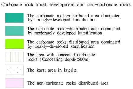
Karstification degree of carbonate rocks can be classified into strong, moderate and weak. The classification is based on the lithology and sedimentary combination types of carbonate rocks and combined with karst landform, individual karst morphology and hydrogeological features,referring to indicators such as surface karst development density, karst proportion of borehole,cave proportion of borehole, flow rate of spring,water yield of single borehole, unit water inflow(Table 1). Strong development features: Purer carbonate rocks with relatively larger continuous thickness and wide distribution, as well as more depressions, sinkholes, dolines on the surface,underground karst caves, large karst springs and underground rivers, where karst developed in deep.Moderate development features: Mostly intercalated less pure carbonate rocks, less depressions,sinkholes, and dolines on surface, less underground cave passages, as well as fewer large karst springs and underground rivers, and poor development of karst in deep. Weak development features: Mainly intercalated or sandwiched impure carbonate rocks, surface karst phenomenon developed sparsely, with fewer underground caves,large karst springs or underground rivers.

Table 1 Karstification degrees of carbonate rocks
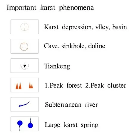
Distribution of covered carbonate rocks mainly refers to the distribution of buried karst covered by Quaternary karst rocks or covered by non-soluble rocks. Distribution of red bed karst mainly refers to the distribution of karst formed in red clastic rocks cemented by calcium or other soluble matters or containing carbonate rock gravels. Important karst phenomena include classic karst depressions,valleys, basins, caves, sinkholes, dolines, tiankeng(giant sinkhole), peak forests, peak clusters,subterranean rivers, and large karst springs, etc.

Fig. 1 Legend of characteristics of karst distribution

Fig. 2 Important karst phenomena
2.2 Expression
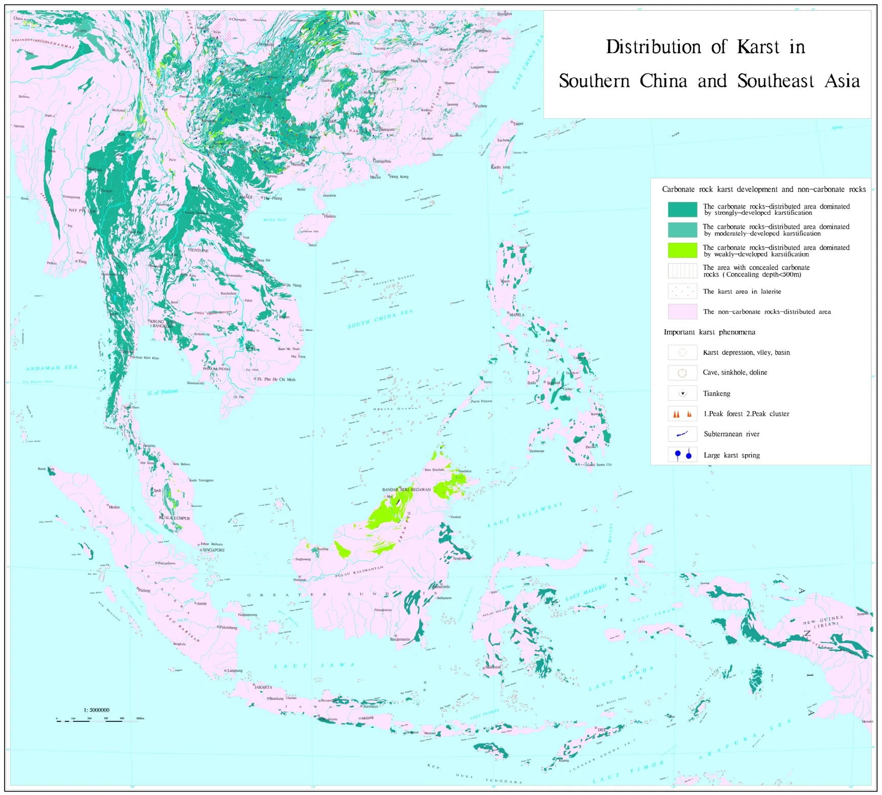
The map covers the special range of South China and Southeast Asia, where the marine area is quite spacious. In order to highlight the distribution of karst on land and make the marine area less prominent on the map, map compiling adopts specific projection parameters, among which the coordinate system is projection rectangular plane coordinate system, the ellipsoid parameter is WGS84, projection type is Lambert azimuthal equal-area projection, longitude at the central meridian is 115°E, latitude at the original point of projection is 10°N. Meanwhile the scale for the map compiling is 1/5 000 000.
In regard to expression of features of karst distribution, appropriate colors and patterns can be selected (Fig. 1) to clearly present karst distribution and its features. The legend in use is basically in accordance with the traditional expression of karst maps (Fig. 2).

Fig. 3 Distribution of Karst in Southern China and Southeast Asia
3 Karst distribution and its characteristics in Southern China and Southeast Asia
Through analyzing the compiled Distribution of Karst in Southern China and Southeast Asia, it is found that karst is widely distributed in Southeast Asia. Karst on Indo-China Peninsula is widely and continuously distributed and developed well. Karst in Malay Archipelago is scattered and developed relatively weakly. Karst in Vietnam is mainly distributed in areas in the north and the middle parts, majorly developing in the Middle Triassic strata; karst in Thailand is mainly distributed in the west, north and the middle parts,majorly developing in Ordovician, Permian and Triassic limestone, especially in the Permian limestone; karst in Myanmar is mainly distributed in Shan Plateau in the East, where karst mainly developed in Devonian carbonate rocks; in Laos,karst is mainly distributed in the north, east and the middle parts, and karst strata is dominated by Permian carbonate rocks; karst in Cambodia is mainly distributed in western border area,northeast part and some coastal area, and covered relatively small area, and it is mainly developed in Carboniferous and Permian carbonate rocks; in Malaysia, karst is majorly scattered in Malay Peninsula, Sarawak and some areas in Sabah; karst is also quite scattered in the Philippines; in Indonesia, karst is mainly distributed in the middle part and islands in the East.
4 Conclusions
This paper introduced the compilation of Distribution of Karst in Southern China and Southeast Asia in terms of the data source,contents, expression and related information and analysis. This map is one of the maps complied by the project Mapping of Karst Geology in China and Southeast Asia, of which the compilation applies the latest research results and maps in China and Southeast Asian countries, and it serves as the result of collective wisdom from all concerned experts in China and Southeast Asian countries. Karst environment is closely correlated with existence and development of human beings,as the continuously deepened research and enhanced awareness of karst environment, transboundary mapping of karst geology is to be further explored more proactively.
Acknowledgements
This project was sponsored by China and Southeast Asia Karst Geology Series Maps Project,China Geological Survey (12120114006301).
杂志排行
地下水科学与工程(英文版)的其它文章
- Distribution of groundwater salinity and formation mechanism of fresh groundwater in an arid desert transition zone
- Study on the influencing factors of rock-soil thermophysical parameters in shallow geothermal energy
- Compilation of serial maps on karst geology of China and Southeast Asia
- Research on hydrogen and oxygen isotopes of paleoclimate reconstruction in Nuomuhong
- Geochemical genesis of geothermal waters from the Longling hydrothermal area, Yunnan, Southwestern China
