Research on hydrogen and oxygen isotopes of paleoclimate reconstruction in Nuomuhong
2015-11-25LIUFengCUIYaliSHAOJingliZHANGGe
LIU Feng , CUI Ya-li*, SHAO Jing-li, ZHANG Ge
1The Institute of Hydrogeology and Environment Geology, Chinese Academy of Geological Sciences, Shijiazhuang 050061, China.
2School of Water Resources and Environment, China University of Geosciences, Beijing 100083, China.
3Xi’an Center of Geological Survey, China Geological Survey, Xi’an 710054, China.
Abstract: As a typical alluvial-proluvial fan area in the Qaidam Basin, Nuomuhong is important to the research on paleoclimate reconstruction in proluvial fan areas and basin climate change and ecological protection. This paper analyzes features of 2H, 3H, 18O and 14C isotopes in Nuomuhong and reconstructs paleoclimate in this area. According to the results:since 28 ka B.P., the ground average temperature decreases and then increases in the Qaidam watershed, reaching the lowest in 17.7 ka B.P. before increasing gradually. In the past 30 000 years, average temperature has changed ranged from 1 to 5℃ ℃ in this area; the lowest temperature was different from today’s temperature only by 3 ℃. This shows that climate conditions and natural environment in this area have been relatively stable in the past 30 000 years.
Keywords: Qaidam Basin; Groundwater; Isotope; Paleoclimate
Introduction
Paleoclimate refers to the climate features of geologic period in the research area. Research on paleoclimate is of great significance to understanding previous climate changes, predicting future climate changes, discovering and validating major geologic and climate events in the geologic period and research on paleo-ecological environment evolution, recharge system of paleo-precipitation and paleo-groundwater. It’s also of great significance to explaining and dividing sedimentary structure, exploring origins and distribution of mineral resources.
Research on paleoclimate mainly includes two parts: Discovering paleoclimate evidences and confirming period of these evidences. Under the climate of a certain period, organics and inorganics including rocks, water body, flora and fauna would impose impacts, thus leaving specific traces, which could be used as evidences to deduce paleoclimate.Loess (Hovan S A et al. 1989), ice core of glaciers(Thompson L G et al. 1997; ZHU Da-yun and WANG Jian-li, 2013), deep phreatic water (FANG Nian-qiao and HU Chao-yong, 2008) can all be used in research on paleoclimate or temperature.Different methods are available for different time ranges and would lead to different degrees of accuracy, with corresponding dating methods,including paleomagnetic method, radio-isotope method and biochemical methods (spore, annual rings, etc.).
Groundwater is an important carrier of paleoclimate information. When atmospheric precipitation recharged groundwater, a lot of climate information was stored, of which, the recharge temperature of groundwater is one of the important indicators to study paleoclimate; at the same time, there is a large amount of groundwater recharged during the geologic period. Therefore,based on the relationship of isotope in groundwater and temperature and dating results of underground,temperature of geologic period and reconstruction of paleoclimate can be estimated. Based on correlation between δD and δ18O in groundwater and recharge temperature of groundwater, this paper calculates the temperature when groundwater was recharged, calculates recharge time based on the correlation between δD and δ18O in groundwater and dating results of groundwater. In this way, temperature and temperature change trend are available. Therefore it’s possible to reconstruct paleoclimate and study the evolution of local climate.
1 Overview of the research area and sampling
1.1 Overview of the research area
Nuomuhong is located in the southeast edge of the Qaidam Basin and is part of Dulan County of the Haixi Prefecture. Nuomuhong is adjacent to Golmud City. It has an altitude of 2 700 m to 3 000 m with the terrain lowering from the south to the north. The south is covered by the piedmont desert of the Boolean Khan Buda Hill and the north reaches all the way to the Hobsun Lake(belonging to the Qarhan Salt Lake) in the middle part of Qaidam Basin. The fine soil plain area between the piedmont desert and the overflow zone of the alluvial-proluvial fan is the major populated area. Nuomuhong River is the main river in this area, the 6thbiggest in the Qaidam Basin (YANG Gui-lin and ZHANG Jing-xian,1996). Areas in the south of the overflow zone are home to spring groups, most of which are depression springs with Beikeliang Spring being the only ascending spring. Springs gather here and thus forming the Nuer Spring, the Haxiwa River and other rivers. Their runoff evaporates and leaks along the way and the rest flows into the South Hobsun Lake. The Haluwusu River, the Qaidam River and the Bayinguole River flow through the central area of south Nuomuhong basin.Intertwined various waterways form lamelliform drainage area (Fig. 1).
The climate of Nuomuhong is cool and extremely arid (QI Ru-ying et al. 2002). According to daily meteorological data from 1957 to 2012 in this area, the annual temperature ranges from 3.6℃ t o 5.4 ℃, with the average being 4.9 ℃ (XING Xing et al. 2014). The weather is cool, with a large temperature difference between day and night.Precipitation is little and evaporation is intensive(JIN Xiao-mei et al. 2013). The annual average precipitation is around 42.7 mm while the annual average evaporation reaches 2 651.2 mm. Poor climatic conditions lead to vegetation scarcity and fragile ecological environment. Therefore,studying local climate history and trend is of great significance to local ecological environment protection and production and living of local people. In recent decades, people have leveraged sporopollen (WAN He-wen et al. 2008),paleomagnetic method (YANG Hui-xin et al.1992), lake sediments (CHEN Zong-yan, 2011)and ice core (ZHU Da-yun and WANG Jian-li,2013) to study paleoclimate in the Qaidam area and achieved fruitful results from different perspectives. As the first trial to reconstruct paleoclimate through the groundwater isotope method, this research focuses temperature and climate since 30 ka B. P., which is a helpful exploration and supplement of local paleoclimate research and the above results.
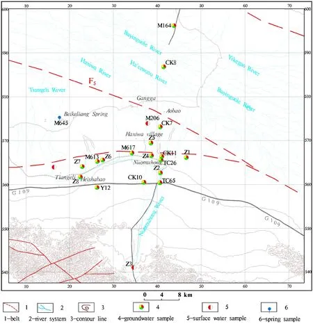
Fig. 1 Hydrogeologic map of Nuomuhong
1.2 Sample collection and test
From 2011 to 2012, samples of3H,2H,18O and14C were collected in the whole area including piedmont surface water, phreatic water, confined water and deeply groundwater in the middle part of the Basin. Stratified sampling was carried out in CK7 drill 200 m deep in the middle part of the Basin. Plastic purified water bottles were used to collect samples of groundwater3H,2H and18O while instruments designed by the Institute of Hydrogeology and Environmental Geology of the Chinese Academy of Geological Sciences were used to collect samples of14C. Samples collected were all sent to the Institute of Hydrogeology and Environmental Geology of the Chinese Academy of Geological Sciences for test, with results shown in Fig. 1.
Golmud is adjacent to the research area and shares similar climatic conditions. According to monitoring data of Golmud meteorological station from 1971 to 2000, local annual average temperature is 5.3 ℃ (WANG Jiang-shan et al. 2004).Predecessors collected isotope samples in Golmud from 1987 to 1988 (SUN Cun-yu, 1991). This paper selects samples with high tritium content to introduce the results into the research and compare them with Nuomuhong samples.
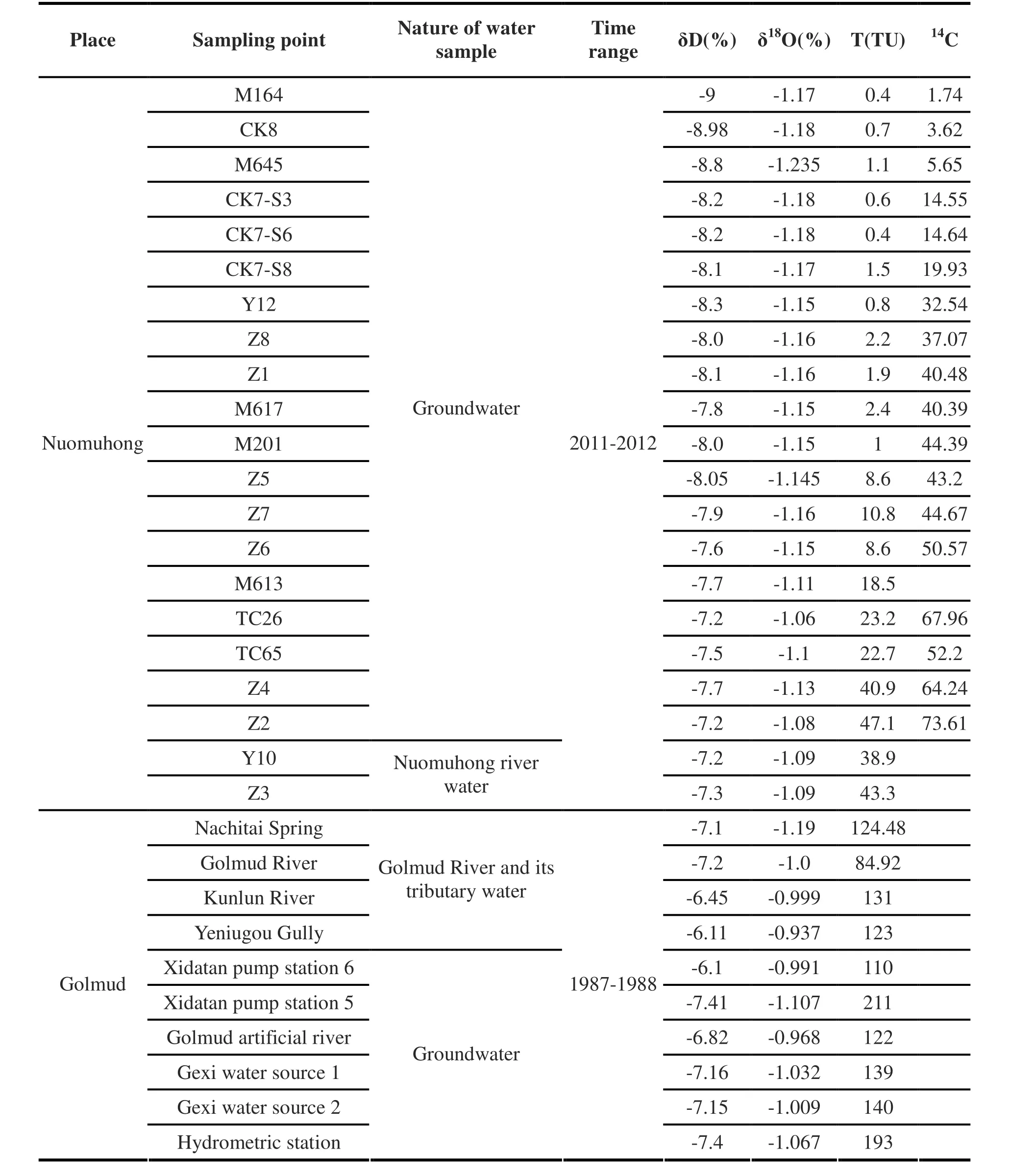
Table 1 Isotopic sample data of water in Nuomuhong and Golmud
2 Research methods
There are various dating methods of groundwater, of which, some are frequently used:14C method,2H-He method,3H method, CFCs method and SF6method. To do this research, we collected samples of groundwater isotopes of2H,18O,3H and14C in Nuomuhong from 2011 to 2012.14C method is used to date fossil water with low tritium content recharged during the geologic period while3H method is used to date modern water with high tritium content. Specific dating method and process have been explained in another paper (LIU Feng et al. 2014), therefore they will not be repeated here.14C and3H test data and dating results are shown in Fig. 1.
There is an obvious linear relation between δD and δ18O value of groundwater and ground average temperature when the ground is recharged by precipation (ZHENG Shu-hui et al. 1983), so the temperature when the groundwater was recharged can be calculated through formula. In recent decades, many experts and scholars have built different relation curves between δD and δ18O and recharging temperature based on test data of different areas. Among these, climatic conditions of Dansgaard formula which suits cold areas in mid- and high-latitudes are similar to the research area; meanwhile, ZHENG Shu-hui built a correlation formula based on data of China east region. These are of important reference signifycance to climatic reconstruction of groundwater in each area in China.
According to Dansgaard research, in coastal areas in mid- and high-latitudes, the relationship between the average annual δD and δ18O value of precipitation and ground temperature (t) in this area is shown in Formula 1 (Dansgaard W, 1964):

Chinese scholar ZHENG Shu-hui and other scholars studied precipitation and temperature in areas along the Beijing-Guangdong railway and then built the relation Formula 2 between ground average temperature and modern atmospheric precipitation which is applicable in China’s east region (ZHENG Shu-hui et al. 1982):

Based on these previous researches, this paper identifies that in recent decades the Nuomuhong atmospheric precipitation’s (groundwater which is younger than 50 years) δD average value is-7.363% (SMOW), δ18O average value is -1.086%(SMOW); in recent decades the Golmud atmospheric precipitation’s δD average value is-6.89% (SMOW) and δ18O average value is-1.03% (SMOW). Combining annual average temperature 4.9 ℃ and 5.3 ℃ of the two places in recent decades, we got the relation Formula 3 between the modern atmospheric precipitation and annual average temperature in Nuomuhong-Golmud areas, which is shown as below:

3 Paleoclimate reconstruction result and analysis
3.1 Paleoclimate reconstruction results
In summary, ground temperature of geologic period in Nuomuhong could be reconstructed through the 3 methods, with the results in Table 2.Through comparing reconstruction results with test data and previous research, we can validate applicability of these formulas.
According to paleoclimate reconstruction results through these 3 methods, the ground average temperature curves from 30 ka until now are shown in Fig. 2.
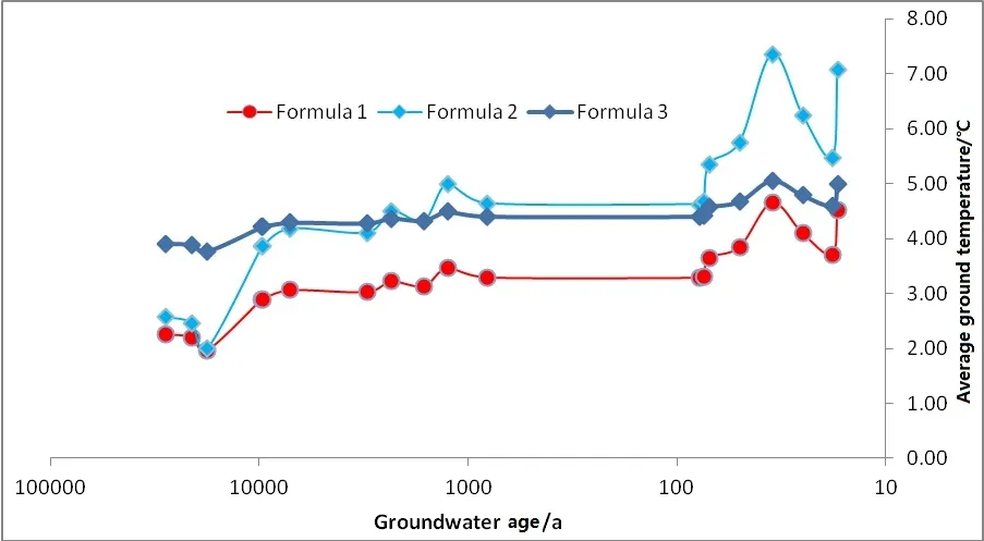
Fig. 2 Relation curves between groundwater and recharging temperature in Qaidam watershed
3.2 Result analysis
Results show that the average ground temperature of modern water recharge through the Dansgaard formula is 3.7-4.7 ℃ with an average temperature of 4.5 ℃ ; the average temperature is 5.5-7.4 ℃ through the ZHENG Shu -hui formula;the average temperature is 4.6-5.1 ℃ through local formula, with the average temperature of 4.99 ℃ . Regarding groundwater older than 100 years, the result of the Dansgaard is close to the result of the formula built based on the relation between local modern groundwater and annual temperature and is basically in line with annual temperature trend in recent decades of the research area. This shows that the results of the above two formula is of certain significance to local modern water temperature reconstruction. ZHENG Shu-hui formula is based on data of hot costal area in east China, whose climate is different from that of the research area; therefore the result is larger than results of the other two formulas.
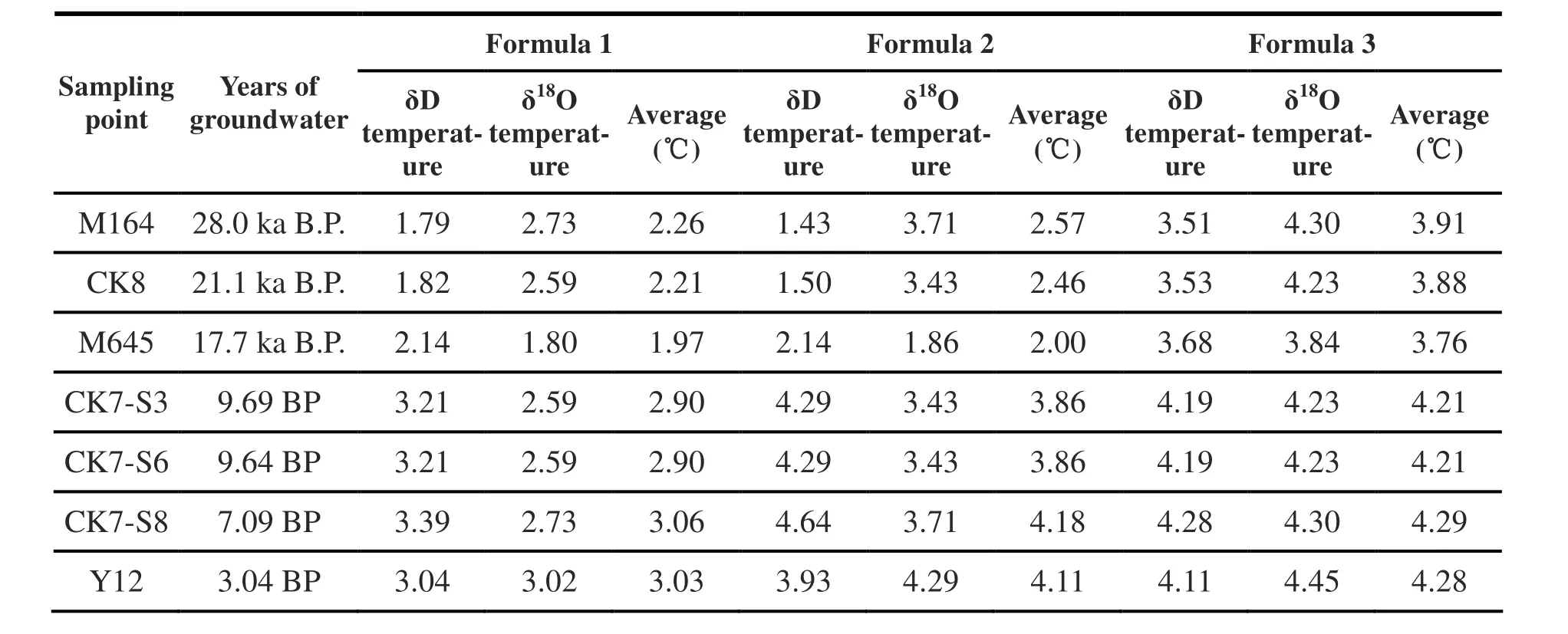
Table 2 Paleoclimate reconstruction results of Nuomuhong
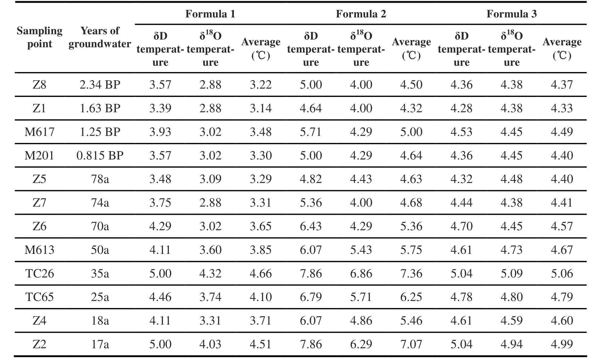
Table 2:Continued
According to paleoclimate reconstruction of the geologic period, the temperature curve of Dansgaard formula is close to that of ZHENG Shu-hui formula: temperature started to drop from 28 000 years ago to 17 000 years ago; temperature started to rise from 17 000 years ago to 7 000 years ago; temperature started to fluctuate from 7 000 years ago. According to the reconstruction result of the local formula, temperature changes are not obvious: the temperature 28 000 years ago is only 1 ℃different from today’s. According to sporopollen records, Wan He-wen and other experts found that from 27.6 ka B.P. to 18.0 ka B.P.,temperature of the Qarhan Salt Lake area had dropped gradually and lakes dried up (WAN He-wen et al. 2008). Through14C method,230Th method and paleomagnetic method, Huang Lin and other experts proved that during 30 ka B.P. and 12 ka B.P., the Qarhan Salt Lake had gradually evolved into a dry salt lake due to severe cold(HUANG Lin et al. 1990). According to mineralogical analysis of lacustrine sediments in drilling cores of the Qaidam Basin, ZHANG Peng-jia and other experts identified 30-12 ka B.P.as cold wet-cold dry period of the area, with the lowest temperature in around 15 ka B.P. before temperature started to rise with fluctuations.Regarding temperature changes and trend, the results of Dansgaard formula and ZHENG Shu-hui formula are in line with previous research results,which prove that these two methods could effectively reflect paleoclimate temperature in Nuomuhong. However, the result of local formula shows that temperature change range is limited;therefore it could not be used to reconstruct paleoclimate.
4 Conclusion and discussion
These results show that:
(1) Dansgaard formula is based on data of various mid- and high-latitude areas around the world, whose low temperature is close to that of Nuomuhong. Temperature result calculated through the formula is less than 0.5 ℃ different from the actual temperature measured; paleoclimate temperature change trend is also in line with previous research results. Therefore,Dansgaard method fits this area and can be used in the follow-up paleoclimate reconstruction.
(2) According to the results, the research area has experienced 2 climatic fluctuation periods since 28 000 years ago, including:
Cold wet-cold dry period: From 28 ka B.P. to 12 ka B.P.; temperature dropped in the beginning,hitting the lowest in around 17.7 ka B.P., close to the Last Glacial Maximum; temperature rose gradually afterwards and stopped rising in around 12 ka B.P.
During the postglacial period from around 12 ka B.P. until today, especially the recent 1 ka to 2 ka, temperature started to rise with fluctuation and the climate is warm and dry, similar to the modern climatic characteristics of this area.
(3) According to the paleoclimate temperature reconstruction result, the ground average temperature of Qaidam Basin ranges from 1 to ℃5 ℃ since 30 000 years ago, with the lowest temperature only 3 ℃ different from today’s temperature. This shows that the temperature change range is limited, which means the climatic conditions and natural environment of the research area have been stable since 30 000 years ago.
5 Existing problems
(1) However, due to more precipitation in the interglacial period than in the glacial period, which means more recharge to groundwater; average ground temperature calculated based on groundwater δD and δ18O data tested after mixing groundwater of different aquifer is higher than the actual average ground temperature of the glacier period (LIU Cun-fu et al. 1997). Therefore the lowest temperature around 17.7 ka B.P. tested in this paper is probably on the high side, and is yet to be corrected through other temperature measurements.
(2) This paper is an initial exploration on studying paleoclimate through groundwater isotopes in Nuomuhong; samples collected are not enough for us to draw a complete temperature-year change curve of Nuomuhong; therefore the division on paleoclimate period is probably not that accurate. We need more samples and categories of groundwater to complete the curve.
Acknowledgements
This study is supported by the Open Fund Project of Groundwater and Ecology Key Laboratory in Arid-semi arid Region of the China Geological Survey; Work Project “Geological Survey on Hydrogeological Environment in Circular Economy Pilot Areas in Qaidam Basin” of the China Geological Survey (1212011220974).
杂志排行
地下水科学与工程(英文版)的其它文章
- Compiling distribution of karst in Southern China and Southeast Asia
- Distribution of groundwater salinity and formation mechanism of fresh groundwater in an arid desert transition zone
- Study on the influencing factors of rock-soil thermophysical parameters in shallow geothermal energy
- Compilation of serial maps on karst geology of China and Southeast Asia
- Geochemical genesis of geothermal waters from the Longling hydrothermal area, Yunnan, Southwestern China
