Distribution of groundwater salinity and formation mechanism of fresh groundwater in an arid desert transition zone
2015-11-25ZHOULilingCHENGZheDUANLeiWANGWenke
ZHOU Li-ling, CHENG Zhe, DUAN Lei, WANG Wen-ke
1Geology Environment Monitoring Institute of Zhejiang Province, Hangzhou, Zhejiang 310007, China.
2Beijing Geotechnical and Investigation Engineering Institute, Beijing 100083, China.
3School of Environmental Science and Engineering, Chang’an University, Xi’an, Shaanxi 710054, China.
Abstract: This study reviews the distribution of groundwater salinity in an arid desert transition zone. By combining field experiments and computer simulation models we make a comprehensive analysis of the formation mechanism of fresh groundwater in relation to the paleogeographic conditions of lithofacies, the geochemical characteristics of the aquifer media,salt deliverability in the vadose zone and prevailing hydrodynamic conditions. The results demonstrate that (1) the lacustrine facies deposition stratum of the Huanhe formation in the Cretaceous system provides a brackish-salt groundwater environment; (2) the average salinity of parent rocks are approximately 440 mg/kg and 4 371 mg/kg in the Quaternary eolian sand and the Cretaceous Huanhe formation respectively, suggesting that parent rocks are the principal controlling factor in the distribution of groundwater quality given that mineral and chemical composition of the eolian sand is simpler than that of the Huanhe formation; (3)average groundwater flow rates are approximately 0.25 m/d and 0.1 m/d in eolian sand and Huanhe formation aquifers respectively, indicating that hydrodynamic conditions play an important role in driving in the formation and evolution of fresh groundwater; (4) The salinity deliverability in the vadose zone overlying the aeolian sand and Huanhe formation aquifers are approximately 15.97 mg/L and 220.42 mg/L respectively, signifying that the combination of lithology and salt content of vadose zone, rainfall infiltration, evapotranspiration and concentration heavily influence the formation, distribution and evolution of groundwater quality. This study can provide a scientific basis for the sustainable development and utilization of groundwater resources in arid areas.
Keywords: Desert transition zone; Distribution of groundwater salinity; Formation mechanism of fresh groundwater; Arid area
Introduction
Water resources are the principal restricting factor to the sustainable economic development of arid regions (DING Zhen-yu et al. 2009). In the arid zone of the northwest China, water resources are poor, particularly in the extreme arid desert region, where there is not only a lack of rainfall but high rates of evaporation.
Distribution, formation and evolution of salt and fresh groundwater resources are studied by many scholars at home and abroad. In the northern Chihuahuan Desert in Texas for example, research found that a Na-Cl type of groundwater was formed due to the effects of irrigation, evapotranspiration and surficial salt recycling, and documented two hydrochemical evolution paths for groundwater in arid lands (Fisher R S and Mullican W F, 1997). Meanwhile, by studying the process of groundwater hydrochemical evolution and pollution by hydrochemical and isotope methods, Favara et al. (2000) considered that Na-Cl type groundwater results from the interaction between surface waters and gypsum and salty clays. Mandour et al. (2008) analyzed the distribution and evolution characteristics of groundwater quality in a semi-arid climate along the Mediterranean coast in North-eastern Morocco.LI Wen-peng and HAO Ai-bing (1999) made generalizations of groundwater formation and evolutionary patterns in the northwest inland basin of China. In this case, groundwater flow systems were divided into piedmont local groundwater flow systems, regional groundwater flow systems,viscous flow groundwater systems and downstream variable local groundwater flow systems, and the characteristics of groundwater salt migration were described as the salt leached zone,the salt migration zone and the salt accumulation zone, and the formation and evolution of groundwater was expounded systematically.Furthermore, GUO Yong-hai et al. (2002) revealed water chemical properties, distribution and the natural formation environment of deep alkaline groundwater on the Hebei plain and the formation and distribution of brackish and fresh groundwater on the Hetao plain in Inner Mongolia was analyzed by WANG Qi (2009).
The majority of previous research focuses on the formation, distribution and evolution of underground salt water, but far less research investigates the formation of fresh groundwater in large areas of saline groundwater. High quality fresh groundwater resources are extremely precious given the unique geological background of arid desert transition zones. Analyzing the distribution characteristics of groundwater quality in the arid desert transition zone and revealing the formation mechanism of fresh groundwater in sand,can provide a scientific basis for the sustainable development and utilization of groundwater resources in arid areas. This knowledge can also have great significance for effective long-term groundwater resource management that maintains environmental and ecological protections.
The study area is located at the southern edge of the Mu Us Desert, where groundwater provides for the main water supply and alternative water resources are scarce. Groundwater salinity in this region is high and water quality is poor over a large proportion of the study area. High quality fresh groundwater only exists in the Sandy region of the Mu Us Desert. This region therefore presents a unique groundwater environment whereby a wide range of saline water is covered by only a small fresh groundwater body.
1 Study area
The study area is located at the south edge of the Mu Us Desert, which belongs to Yanchi County,Ningxia Hui Autonomous Region (Fig. 1). The terrain in this region is relatively flat, with an elevation ranging between 1 300-1 500 m. Geomorphologically the region is a wavy plateau, with the altitude of the southwest portion higher than the northeast. The continental arid and semi-arid monsoon climate is prone to drought periods characterized by lack of rainfall and high levels of evaporation. The mean annual precipitation is 292.47 mm, of which the main rainfall which accounts for 72.3% of the total annual rainfall takes the form of heavy rain usually occurring between June and September.
The strata of the exposed bedrock in our study area-from oldest to newest-are as follows: (1)Huanhe formation of the Cretaceous system-is a set of brownish-red or brownish-yellow fine sandstones and mudstone or sandy-mudstone interbed, with cross-beddings developed in local areas; (2) Luohandong formation of the Cretaceous system-is characterized by orange or light brownish-red feldspathic fine sandstones with brownish-red or purplish-brown mudstone and sandy mudstone interbed; (3) Quaternary strata, the lithology being mainly of eolian sand and silty sand, widely distributed in study area (Fig. 2).
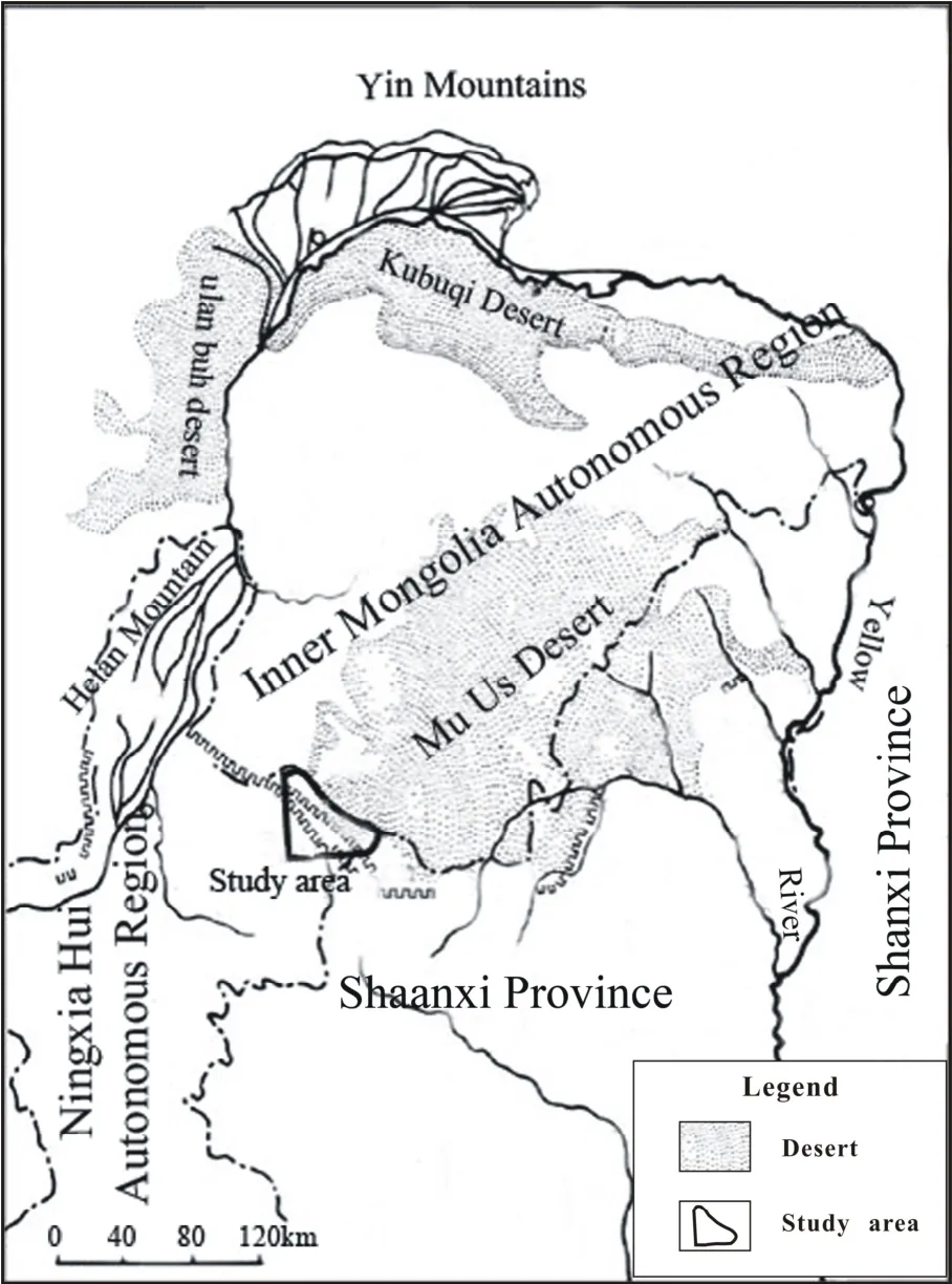
Fig. 1 Location of the study area at the southwest edge of the Mu Us Desert in China
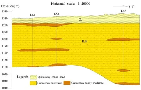
Fig. 2 Hydrogeological profile of the Mu Us Desert study area in China
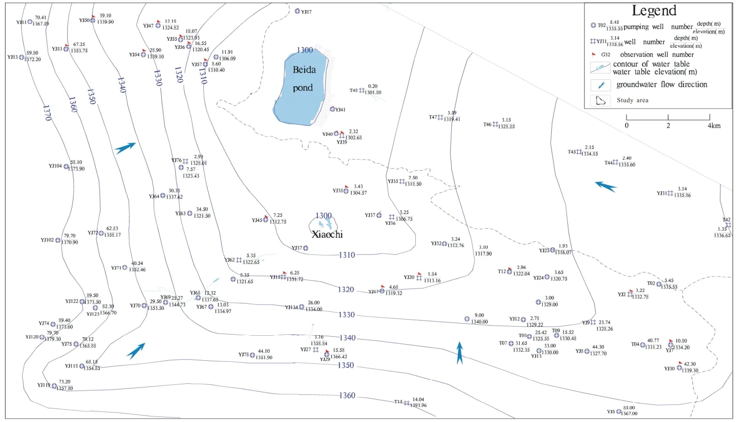
Fig. 3 Contour of groundwater table in the study area in the southwest edge of the Mu US Desert in China
Fissure-pore water of Cretaceous clastic rock is widely distributed in the study area. The main aquifer group is related to the thick Huanhe formation lithology of mainly fine sandstone and siltstone interbed, including argillaceous sandstone and sandy mudstone locally. Groundwater quality is poor. In comparison, quaternary pore water exists only in the Mu Us Sandy Desert, which borders the study area to the northeast. In this region the aquifer thickness is from several meters to tens of meters, with the lithology of light yellow or brown yellow silty-fine sand. Quaternary pore water is of high quality, and constitutes an interrelated and unified water system with the underlying Cretaceous groundwater aquifer.
Groundwater in the study area is recharged mainly through outside lateral flow and precipitation infiltration, and discharged by evapotranspiration. When overflow occurs it presents as surface water such as ponds and artificial exploitations. Groundwater flows to the Beida pond, which is the discharge center (Fig. 3).
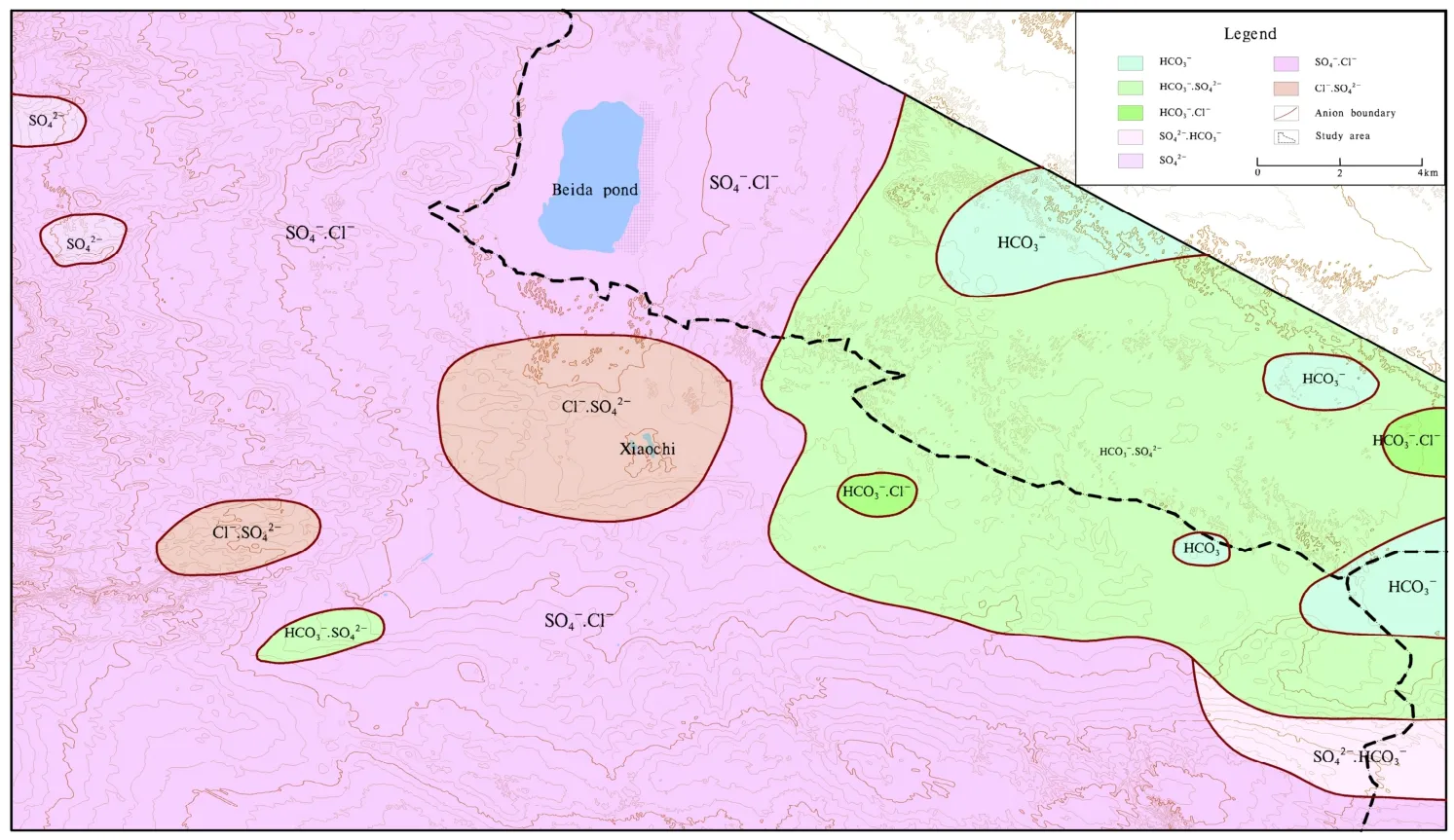
Fig. 4 Hydrochemical types of groundwater within the study area
2 Groundwater chemistry within the study area
2.1 Hydrochemistry-different types
In total, the 173 groundwater samples and results we collected demonstrated that hydrochemical types of groundwater are complicated in our study area. Furthermore,according to the division standard of anions,around seven hydrogeochemical types exist in the study area such as HCO3, HCO3·SO4, HCO3·Cl,SO4·HCO3, SO4, SO4·Cl and Cl·SO4(Fig. 4).Among them, SO4·Cl, HCO3·SO4and Cl·SO4are types for which distribution and range are large,compared to the relatively small distribution and range of the other hydrogeochemical types.
2.2 Distribution of groundwater salinity
Brackish groundwater is distributed throughout most of the study area. Conversely fresh groundwater and saline groundwater are found only in a small area (Fig. 5). Through the analysis of drill hole samples, it was evident that the degree of groundwater mineralization increases on the vertical gradient.
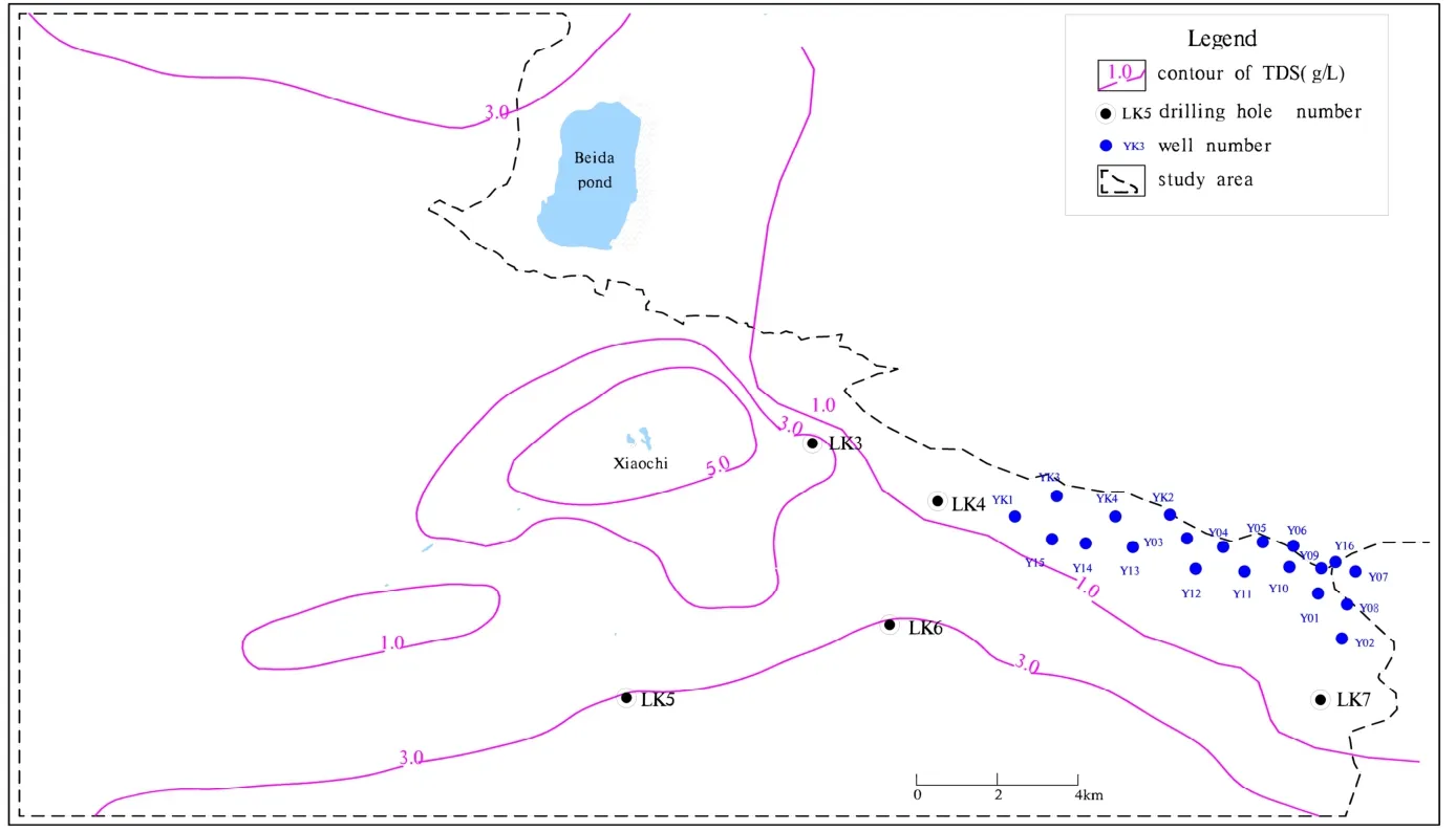
Fig. 5 Distribution of brackish and fresh groundwater in the study area
3 Material and experimental methods
A group of 13 drilling core samples were collected in the study area for mineral and chemical composition analysis and soluble salt experiments. Leaching experiments were conducted using 2 kinds of typical samples collected from the vadose zone that overlayed the eolian sand and Huanhe formation. The lithologies of the samples are silty-sand and sandy-silt respectively.The mineral analysis method we used refers to the X-ray diffraction method of mineral structure(DS-2613201-04), and the chemical analysis refers to the non-metallic mineral and rock chemical analysis method (JC/T1021-2007). The soluble salt experiment method refers to the geotechnical experiment method standard (GB/T-50123-1999).Leaching experiments were conducted using distilled water and an organic glass column with an inner diameter of 15 cm (Fig. 6). A 3 cm thick layer of quartz sand was laid over fiber net to pave the bottom of the column. Vaseline was evenly smeared around the column wall and then the samples were loaded. It was important to maintain a uniform compactness in the samples while they were loaded. And additional layer of fiber net and a 1 cm thick layer of quartz sand were paved over the sample after loading. Once the sample was installed, the leaching column was filled from the bottom with distilled water. Afterwards, the distilled water was changed to recharge from the top of the column to ensure continuous leaching of the sample and maintain a stable waterhead. The time was recorded as the ‘0 point’ to mark the beginning of the leaching experiment. Around 250 ml of the leaching liquid was collected from the bottom of the leaching column. Indexes measured included pH, Eh, electrical conductance,total dissolved solids (TDS), concentration of Cl-,SO42-, CO32-, HCO3-, NO3-, K+, Na+, Ca2+, Mg2+and F-, and were measured until the leaching solution achieved stability. Samples of each lithology were loaded at varying heights to contrast results-at 30 cm, 60 cm and 90 cm.
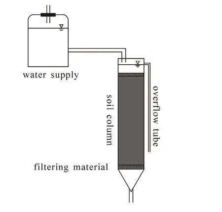
Fig. 6 The experimental device used to conduct the leaching experiment
Mineral and chemical composition analysis was accomplished by experimental testing at the Xi’an Institute of Geology and Mineral Resources.Soluble salt and leaching experiments were completed in the Key Laboratory of Subsurface Hydrology and Ecology in Arid Areas, Ministry of Education.
4 Analysis and discussion
4.1 Conditions of paleogeographic lithofacies
A large volume of previous research indicates that the Ordos Cretaceous groundwater basin is composed of sets of superimposed and lateral staggered Cretaceous groundwater aquifers, which have local hydraulic connection and differ in their properties (XIE Yuan et al. 2003; XIE Yuan et al.2004; QI Hua et al. 1993; JIANG Xin-sheng et al.2000). The Huanhe formation of the Cretaceous system is the most widely distributed stratum in the study area (GAO Wen-bing, 2005), and it is composed of lacustrine facies, fine clastic rocks and deposited argillaceous rocks, mingled with gypsum mudstone and siltstone. The region’s climate is arid and semi-arid, with high levels of evaporation and a lack of precipitation. Exacerbating the effects of the arid climate, the study area is located in the catchment area of the groundwater system, and salt is concentrated easily due to the slow flow of groundwater run-off. Consequently,the Huanhe formation’s lacustrine facies deposition stratum of the Cretaceous system forms a brackishsalt groundwater environment under the influence of factors such as paleoclimatic drought conditions,the high salinity of sedimentary water bodies and rocks, and sluggish groundwater circulation.
4.2 Geochemical characteristics of aquifer media
The soluble salt experiment and the mineral and chemical composition analysis revealed the geochemical characteristics of aquifer media.

Table 1 Soluble salt and ion content of aeolian sand
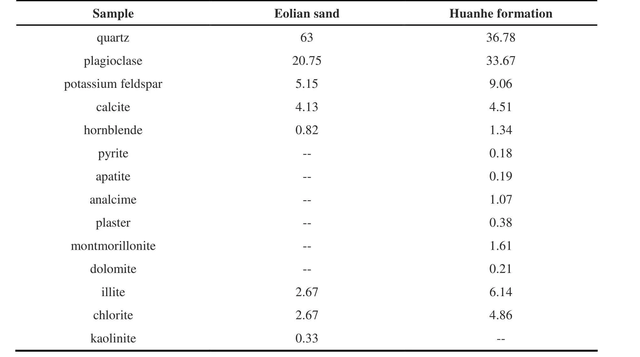
Table 2 Mineral analysis of the aquifer media (%)
A total of 13 rock core samples were collected from the drilling hole, derived from depths ranging between 7.8 m and 400.6 m. The rock core samples were used to measure the concentration of K++Na+, Ca2+, Mg2+, Cl-, SO42-, HCO3-, CO32-and F-ions. The results demonstrated that the total average content of soluble salt in aeolian sand is 0.44 g/kg (Table 1), and the content of each component is low.
The soluble salt content of Huanhe formation presented the characteristic of less in upper and lower parts and more in the middle part. The average saltness was 4.371 g/kg, which was about ten times than that of aeolian sand. Thus, it could be seen that the content of soluble salt of eolian sand aquifer was much less than that of underlying Huanhe formation.
The predominant minerals comprising the aquifer media are quartz, plagioclase, potassium feldspar, calcite, illite, chlorite (Table 2, Table 3).Moreover, aeolian sand was found to contain hornblende and kaolinite, while the Huanhe formation contains montmorillonite, hornblende,analcime, dolomite, and plaster was detected in some areas. These results demonstrate that the mineral composition of eolian sand is relatively simpler than that of the Huanhe formation, with quartz being the main component while other minerals remain in low concentration. Our chemical composition analysis results corroborate these findings, revealing that in aeolian sand the contents of minerals other than SiO2are low.
The results of both the soluble salt experiments and mineral and chemical composition analysis show that the mineral and chemical composition in aeolian sand aquifer is relatively simple, and the salinity of parent rock is far lower than that of the Huanhe formation. These findings tell us that the distinctiveness of the aquifer media constitutes the basic environment of different groundwater storage and transport, and take a controlling role in the formation of groundwater quality.
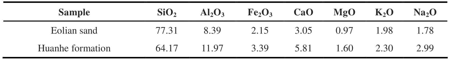
Table 3 Chemical analysis of the aquifer media (%)
4.3 Salinity deliverability of the vadose zone
Salinity deliverability of vadose zone media with different lithologies can be determined through the results of our leaching experiments.During identical experimental conditions with identical lithology, the higher the column the higher the salinity of the leaching liquid, while the salinity of the leaching fluid from sandy silt is more than that from silty sand by using the columns of the same height (Fig. 7, Fig. 8). When leaching experiments achieve stability, the salinity of the leaching liquid from silty sand at heights of 30 cm, 60 cm and 90 cm are 28.93 mg/L,39.07 mg/L and 49.97 mg/L respectively, while the salinity of leaching liquid from sandy silt are 163.93 mg/L, 226.87 mg/L and 340.50 mg/L respectively. The salinity of distilled water is 23.35 mg/L, and the content of chloride ion is 4.97 mg/L.Thus the net dissolving-out quantity of salinity can be calculated when per unit volume of water flows through different lithologies and different heights of rock-soil bodies on the same experimental conditions (Table 4). The average soluble salt deliverability of silty sand is 15.97 mg/L, within which the concentration of chloridion is 0.04 mg/L.The average soluble salt deliverability of sandy silt is 220.42 mg/L, within which the concentration of chloridion is 0.44 mg/L.
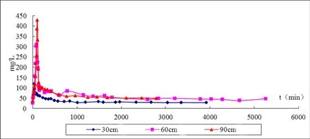
Fig. 7 TDS variation of silty sand
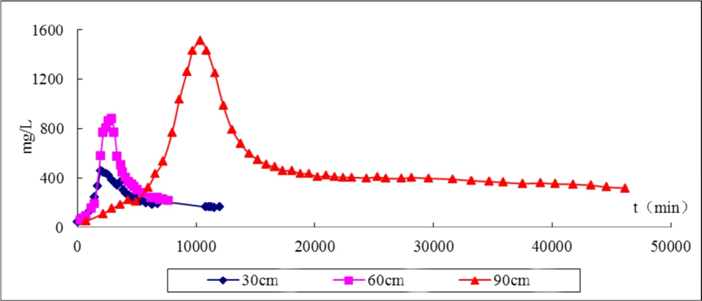
Fig. 8 TDS variation of sandy silt
Thus, the salinity deliverability of silty sand overlying the aeolian sand aquifer is much less than that of sandy silt overlying the Huanhe formation aquifer, and silty sand is more conducive to recharge via rainfall infiltration. Moreover,silty-sand can effectively reduce the invalid evapotranspiration of shallow groundwater in arid areas due to the small extinction depth. In all, these factors are vital influences on the formation of fresh groundwater.
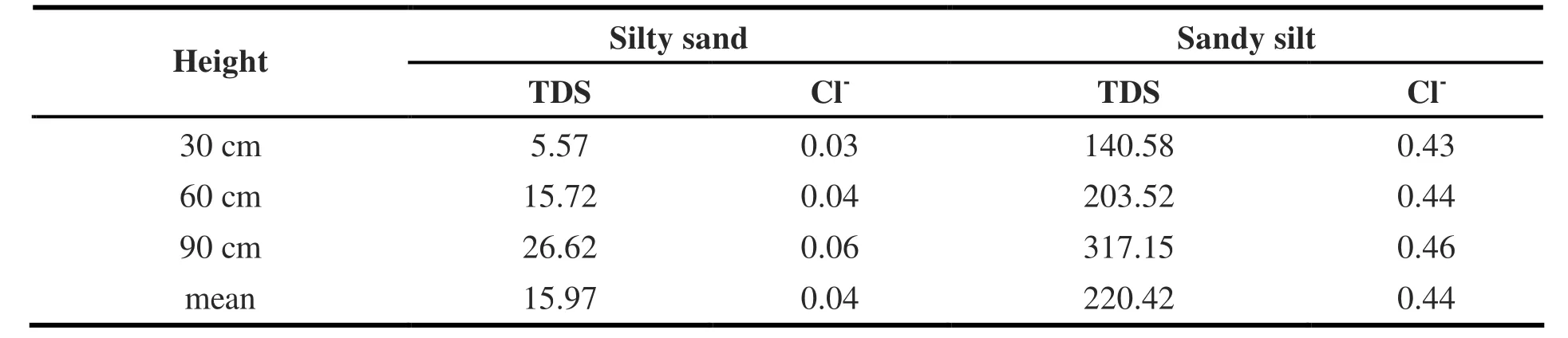
Table 4 Soluble salt deliverability of each lithology
4.4 Hydrodynamic conditions
A groundwater flow and solute transport simulation model was established by visual MODFLOW combining with the characteristics of the study area and developed in consultation with previous research by ZHANG Hui (2007). The optimized simulation area is shown in Fig. 9. The groundwater flow field was calculated after the identification and verification of the model. The calculation results are divided into a stronger runoff zone, a general runoff zone, a weaker runoff zone and the weakest runoff zone according to the flow rate in 0.2-0.5 m/d, 0.1-0.2 m/d, 0.05-0.1 m/d and <0.05 m/d respectively (Fig. 10). It is clear from these results that the groundwater flow rate of the eolian sand aquifer is stronger than that of the Huanhe formation in the south of study area. The flow rate is average in the mixed zone of salt and fresh groundwater, while close to the discharge center the groundwater runoff near Beida pond is sluggish. Thus, the hydrodynamic condition of eolian sand aquifer is far superior to that of the Huanhe formation, and the stronger the exchange of groundwater, the faster salt excretion, the more favorable to saline water desalination. Clearly, the positive water circulation conditions in eolian sand play an important role in driving the formation of fresh groundwater.
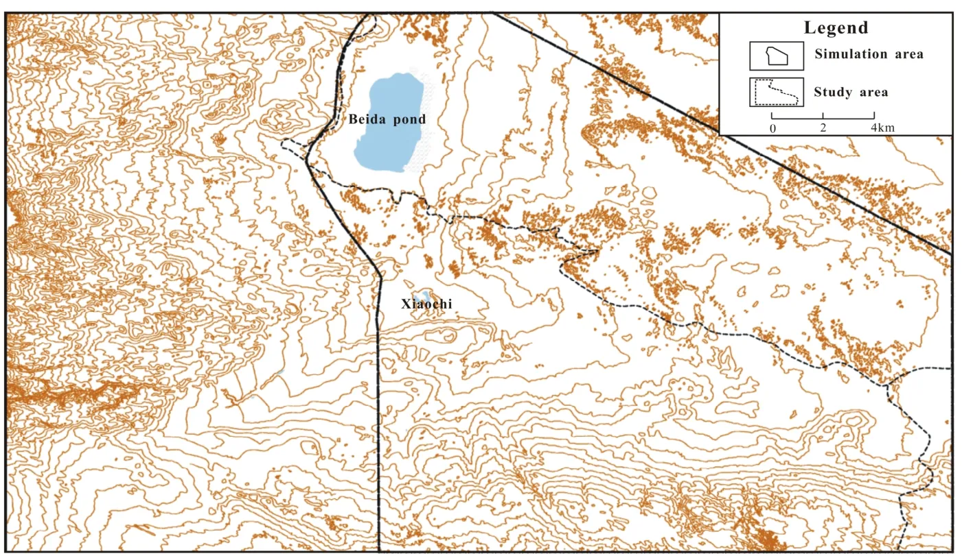
Fig. 9 The optimized simulation area of groundwater in the study area

Fig. 10 Hydrodynamic zoning map of shallow groundwater in the groundwater simulation area
4.5 Mechanisms of fresh groundwater formation
A profile of an east-west direction passes through the Quaternary eolian sand and the Cretaceous Huanhe formation, ultimately reaching the Xiaochi discharge. The concentration of Cl-, as well as groundwater flow velocity and depth of the water table at various points along the profile are illustrated in Fig. 11.
Our results indicate that the Quaternary eolian sand aquifer is in a positive circulation state and belongs to the leached groundwater zone. The mean salinity of parent rock is about 440 mg/kg,and the average groundwater flow velocity is about 0.25 m/d. The evaporation effect is weak due to the depth of water table being primarily greater than the extinction depth. As a result, groundwater is of high quality. The Huanhe formation of the Cretaceous system belongs to the evapotranspiration-leached and brackish-fresh groundwater mixed zone. The average salinity of parent rock is about 4 371 mg/kg, and groundwater flows slower with an average flow velocity of about 0.1 m/d.The depth of the water table fluctuates at the level of extinction depth, and brackish water and fresh water mix gradually. As a result, the degree of mineralization in the groundwater of the zone rises gradually. The Xiaochi discharge area is located within a strong evapotranspiration and concentration effect zone. The groundwater flow rate here is almost zero and therefore in a state of stagnation.The depth of water table is so close to the surface that the groundwater is always artesian. Groundwater salinity reaches its peak in this zone, and surface soil salinization occurs.
In the study area we have found that the sedimentary rock of the Cretaceous Huanhe formation is rich in salt, and provides a large number of salt to the aquifer to form saline groundwater with poor quality. In comparison, the parent rock of the Quaternary eolian sand aquifer has a low salt content, and accepts a large amount of precipitation and lateral flow recharge with high quality from the Mu Us Sandy Desert. Combined with good hydrodynamic conditions and little evapotranspiration, saline groundwater in the Huanhe formation is mixed, diluted, desalted and displaced gradually by the groundwater in the Quaternary eolian sand aquifer, and finally there is a stable freshwater body formed.
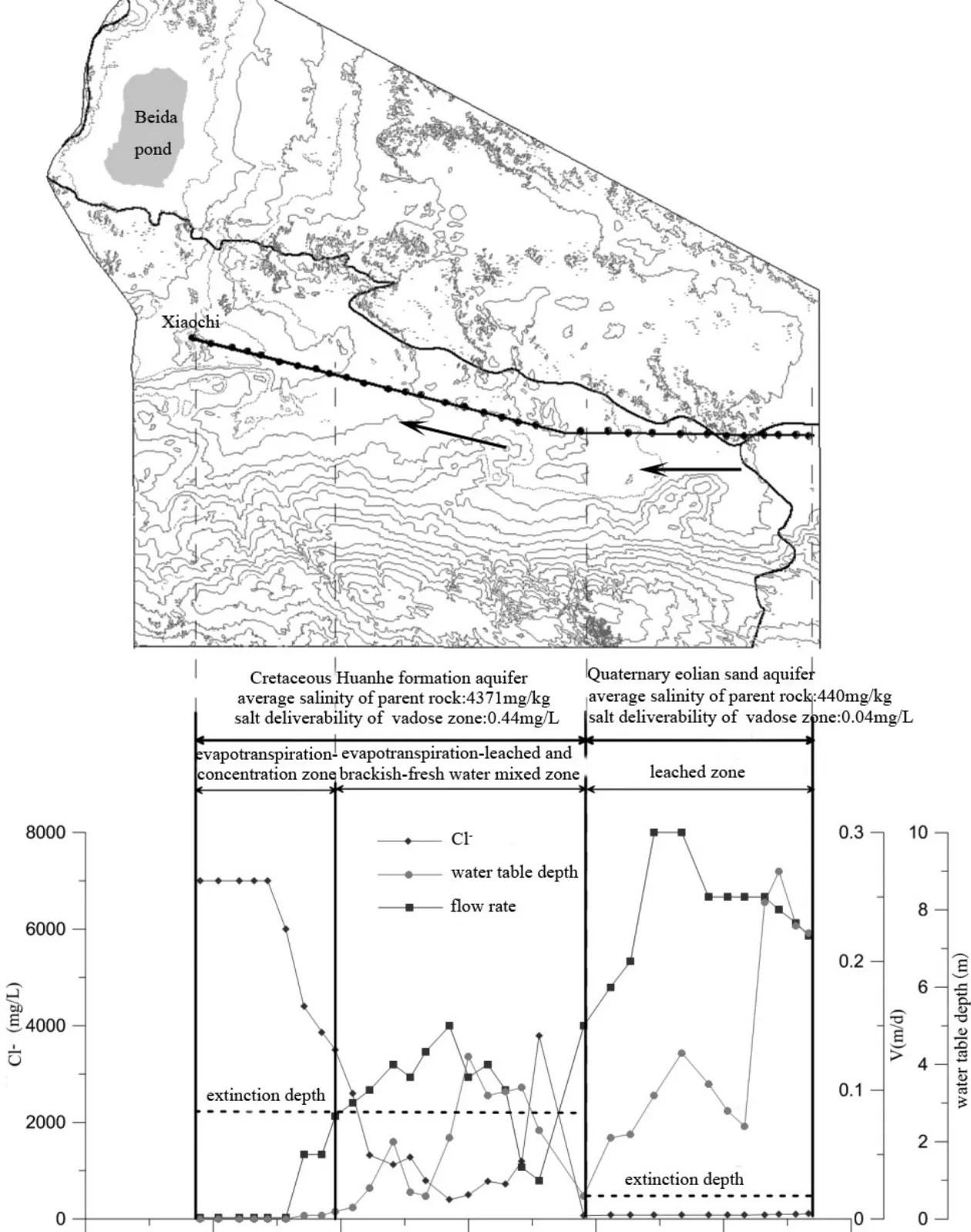
Fig. 11 Formation and evolution mechanism of fresh groundwater
5 Conclusions
In conclusion, the controlling factors in the distribution of groundwater quality are related to the differences between parent rocks of the Cretaceous Huanhe formation and Quaternary eolian sand. These differences fundamentally determine variation in groundwater quality in different aquifer media. Hydrodynamic conditions play an important role in driving the formation and evolution of fresh groundwater, and positive groundwater circulation is of great significance to the formation of high quality water. Moreover,rainfall infiltration, evapotranspiration and concentration, in combination with the lithology and salt content of the vadose zone are vital influences on the formation, distribution and evolution of groundwater quality.
Acknowledgements
This research work was supported by the“Groundwater exploration of energy base in the Ordos basin (Ningxia)” (No. 1212011121162) of China Geological Survey.
杂志排行
地下水科学与工程(英文版)的其它文章
- Compiling distribution of karst in Southern China and Southeast Asia
- Study on the influencing factors of rock-soil thermophysical parameters in shallow geothermal energy
- Compilation of serial maps on karst geology of China and Southeast Asia
- Research on hydrogen and oxygen isotopes of paleoclimate reconstruction in Nuomuhong
- Geochemical genesis of geothermal waters from the Longling hydrothermal area, Yunnan, Southwestern China