Geochemical genesis of geothermal waters from the Longling hydrothermal area, Yunnan, Southwestern China
2015-11-25GUOQinghaiZHANGXiaoboLIUMingliangLIJiexiangZHOUChaoZHANGCanhaiZHUMingchengGUOWeiWANGYanxin
GUO Qing-hai, ZHANG Xiao-bo, LIU Ming-liang, LI Jie-xiang, ZHOU Chao, ZHANG Can-hai,ZHU Ming-cheng, GUO Wei, WANG Yan-xin
1State Key Laboratory of Biogeology and Environmental Geology & School of Environmental Studies, China University of Geosciences, Wuhan 430074, China.
2Hydropower Development Corporation of Upper Yellow River (Ltd.), Xining 810008, China.
Abstract: Longling is characterized by a wide distribution of hydrothermal areas, among which the Banglazhang hydrothermal system is the most geothermally active. Banglazhang is marked by intensive hydrothermal activities including hot springs, geysers, fumaroles and hydrothermal explosions. The geothermal waters from the Longling region are mainly HCO3-Na type with low but comparable SO4 and Cl concentrations. Calculations based on a variety of chemical geothermometers and a K-Ca geobarometer indicate that the Banglazhang hydrothermal system has much higher subsurface temperature and CO2 pressure compared to the other systems such as Daheba, Dazhulin and Huangcaoba. However, geothermal water samples collected from all these alternative hydrothermal areas are either partially equilibrated with reservoir minerals or are immature. The silica-enthalpy relationships of Banglazhang geothermal waters indicate the presence of a deep geothermal fluid with an enthalpy value and silica concentration of 945 J/g (up to around 220 °C) and 339 mg/L. Our work indicates the Banglazhang area is a promising source in terms of long-term utilization of hydrothermal resources.
Keywords: Geothermal water; Geochemical genesis; Geothermometer; Geobarometer; Deep geothermal fluid; Longling; Banglazhang
Introduction
Longling is located adjacent to Tengchong, the most extensive volcanic geothermal area in China(TONG Wei and ZHANG Ming-tao, 1989), and is also characterized by the occurrence of many hydrothermal areas such as Banglazhang, which is the largest and most active with a total area of around 0.2 km2(Fig. 1). The Longling region,including the Banglazhang geothermal field,belongs to the Baoshan Prefecture of Yunnan Province in southwestern China. Various manifestations of hydrothermal activities can be observed in Banglazhang, including hot springs,small-scale geysers, fumaroles and intensive hydrothermal alterations. A series of hydrothermal explosions have also been recorded from the northwestern part of the Banglazhang field after a large-scale Longling earthquake in 1976, resulting in the formation a hot spring with the highest outlet temperature (97°C) among all Banglazhang springs (LIU Yong-tao, 2009). However, a comprehensive understanding of the geological origin of the Longling hydrothermal systems(including Banglazhang) is lacking and the reservoir processes occurring below these fields are not fully understood. This paper aims to delineate the genesis of the Longling geothermal waters through a geochemical survey of the region.The results of this survey are vital for future sustainable and effective exploitation of hydrothermal resources in Longling.
1 Regional geology and hydrogeology
Longling experiences a subtropical-monsoon type climate, with a mean annual air temperature of 16.9°C. For the purposes of our study, the Banglazhang hydrothermal area is the focus for geothermal water sampling, located 12 km northwest of the town of Longling (the seat of the government of Longling County) (Fig. 1), and with an altitude range of 1 254-1 280 m. The Xiangbai River is the major surface water source in Banglazhang, flowing east to west through the area and discharging into the Longchuan River. Three additional geothermal areas of Daheba, Dazhulin and Huangcaoba are quite close to the Banglazhang area, but are all much smaller and weaker in terms of total area and intensity of hydrothermal activity. These alternatives geothermal areas were also investigated alongside Banglazhang.
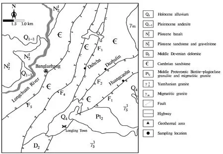
Fig. 1 A simplified geological map of the Longling region illustrating broad geological structure,rivers and settlements
The bedrock outcroppings of the study area are comprised of Holocene alluvium, Pliocene sandstone and gravelstone, Middle Devonian dolomite, Cambrian quartz sandstone and feldspar sandstone, and Middle Proterozoic Biotiteplagioclase granulite and migmatitic granite.Magmatic rocks including Himalayan andesite and basalt and Yanshanian granite were also found(Fig. 1). To date, no boreholes have been drilled in the Banglazhang hydrothermal area, but according to patterns in the surface geology (Fig. 1), it is likely the reservoir host rocks below Banglazhang are Proterozoic metamorphic rocks. It is interesting to note the surface hydrothermal manifestations in both Banglazhang and the neighbouring geothermal areas Daheba, Dazhulin and Huangcaoba are distributed at the conjunction with a group of faults trending in a northeast-southwest direction (Fig. 1)and also the Xiangbai River valley in a predominantly east-west direction. These two observations suggest that these hydrothermal systems are all fault-controlled.
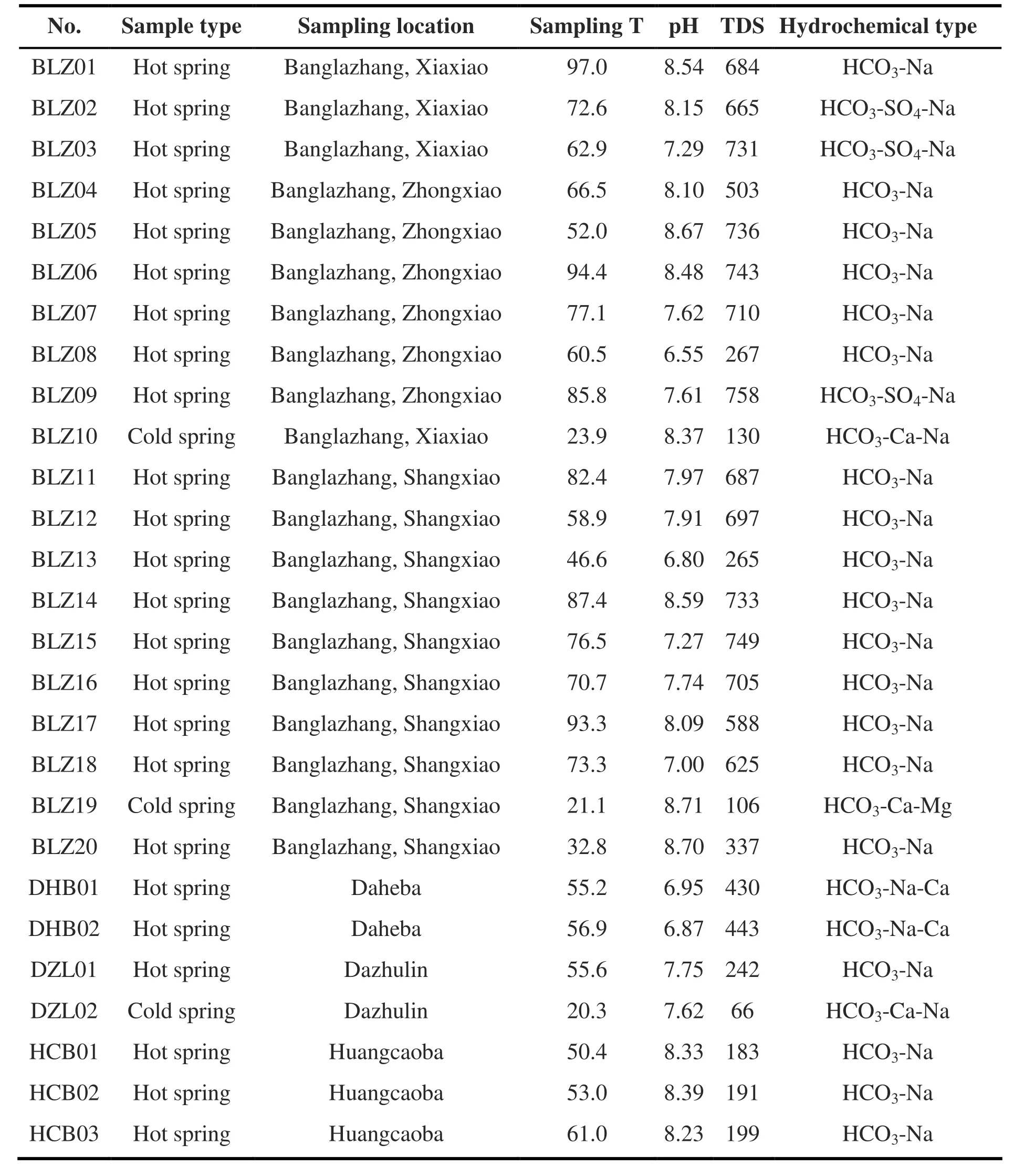
Table 1 Characteristics of water samples (sampling temperature in °C and TDS in mg/L)
The tritium concentrations of Banglazhang geothermal waters reported by LIU Yong-tao(2009) are 3.5 ± 1.2 TU, suggesting that the major recharge source of the Banglazhang hydrothermal system is meteoric water. The concentration also indicates a relatively long residence time and flow path of Banglazhang geothermal waters before discharge. Compared to cold groundwater sources in Banglazhang, the geothermal waters of the area have lower δ18O and δD values. A simple calculation using water isotopes reveals that the elevation of recharge areas for Banglazhang geothermal waters range from 1 360 to 1 880 m,whereas those for the cold groundwater there are between 1 420 to 1 520 m. This implies that the cold groundwater occurring in Banglazhang are very likely recharged by local precipitation, in view that the elevation range of the recharge area is just a little higher than that of the Banglazhang field. In contrast, as indicated by their generally higher elevations, the recharge areas for the Banglazhang geothermal waters are very likely to originate in mountainous areas away from the field.
2 Materials and methods
A total of eighteen hot spring samples were collected from the Banglazhang hydrothermal area and six from the neighboring hydrothermal areas Daheba, Dazhulin and Huangcaoba. In addition,two cold springs were sampled in the Banglazhang area, and one from Dazhulin area. Specifics of the sampling sites, their major characteristics and the hydrochemical types of water samples are presented in Table 1.
All water samples were filtered through 0.45 μm membranes on site. Samples were stored in 300 mL prerinsed polyethylene bottles. For cation analysis, reagent-grade HNO3with molar concentration up to 14 M was added to one sample collected at each site to bring the pH level to below 1. For SiO2analysis, samples were diluted ten-fold using deionized water to prevent precipitation of the SiO2in solution. Water temperature and pH, as unstable parameters, were measured with hand-held meters that were calibrated prior to sampling. H2S was determined in situ using an HACH colorimeter. Although a HACH colorimeter was employed to quantify ammonium concentration in water samples, ammonium was not detected in all samples. Total alkalinity was measured using the Gran titration method on the sampling day, based on which concentration of HCO3-, CO32-and CO2were calculated by use of PHREEQC code (a widely used hydrogeochemical code) incorporating WATEQ4F database(Parkhurst D L and Appelo C A J, 1999). The concentration of SO4, Cl and F was determined on an unacidified sample by ion chromatography. The concentrations of Na, K, Ca, Mg, Li, Sr, Ba, Al, Fe,Si, B, As and Se were analyzed by ICP-OES, and those of Rb, Cs and Sb by ICP-MS two weeks after sampling.
3 Results and discussion
3.1 Hydrochemical characteristics
In the Banglazhang hydrothermal area, the hydrochemical types of geothermal water are predominantly HCO3-Na, excepting three samples which were mainly HCO3-SO4-Na. All geothermal water samples contain HCO3-and Na+as the predominant anion and cation respectively (Fig. 2),whereas the concentration of Ca and Mg is low with average values of 4.73 and 0.53 mg/L respectively. The concentration of F in the Banglazhang geothermal waters is remarkably high(up to 27 mg/L). Another significant geochemical feature of the Banglazhang samples is that the higher SO4-Cl molar ratios, the lower Cl concentration compared to those from several representative high-temperature geothermal fields in China, such as Yangbajing and Rehai (Fig. 3). In contrast to the geothermal waters sampled at Banglazhang sites, those collected from Daheba,Dazhulin and Huangcaoba have lower values of total dissolved solid (TDS). It is also worth noting that the concentration of most cations in geothermal water, such as Na, K, Li, Rb and Cs,generally decreases from Banglazhang to Daheba to Dazhulin to Huangcaoba, possibly indicating that the subsurface temperature and the intensity of geothermal fluid-rock interactions decline in line with increasing distance from the Banglazhang area (Fig. 1). Moreover, the Cl-B and Cl-F ratios of the Banglazhang geothermal samples (except for BLZ18) are quite close, while those of other geothermal water samples and cold groundwater samples vary greatly (Fig. 4).
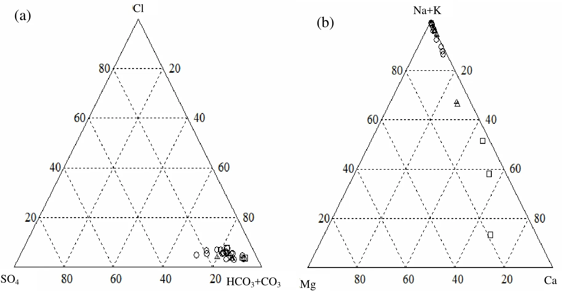
Fig. 2 Relative Cl-, SO42- and HCO3- (+CO32-) concentrations (a) and Na (+K), Mg and Ca concentrations (b) of all water samples (in equivalents)Legend: ○ geothermal water samples collected from the Banglazhang geothermal area;△geothermal water samples collected from Daheba, Dazhulin and Huangcaoba;□ cold groundwater samples collected from Banglazhang and Dazhulin.Unless specified otherwise, this legend is consistent for other figures.
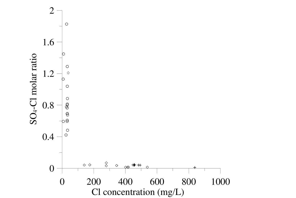
Fig. 3 Plot of SO4-Cl molar ratio vs. Cl concentration of the geothermal waters from Banglazhang (this study), Yangbajing (Guo Q H et al. 2007) and Rehai (Guo Q H and Wang Y X, 2012).Legend: ○ Banglazhang samples; + Yangbajing samples; ◇ Rehai samples.
3.2 Estimation of subsurface temperature
Chemical geothermometers that are based on temperature-dependent change in solubility of individual minerals (e.g. quartz or chalcedony geothermometer) and exchange reactions concerning two or more minerals (e.g. Na-K, K-Mg,Na-Li or Li-Mg geothermometer) are not only useful for reservoir temperature calculations, but also helpful for appraising the equilibrium status of geothermal waters and identifying their geochemical genesis. For the Banglazhang geothermal springs, the subsurface temperature estimated using geothermometers of Na-K(Giggenbach W F et al. 1983), K-Mg (Giggenbach W F, 1988), quartz (Verma S P and Santoyo E,1997) and chalcedony (Fournier R O, 1977) (Table 2) is much higher than the water sampling temperatures. The temperatures calculated with K-Mg and silica geothermometers is comparable but significantly lower than that calculated with the Na-K geothermometer. These differences suggest that K-Mg and silica geothermometers reflect the geothermal water temperature of nearby spring outlets as they re-equilibrate very rapidly upon cooling and at similar rates, whereas the Na-K geothermometer records temperature at greater depths. Moreover, for samples with K-Mg temperature around 150 °C, the quartz geothermometer shows better agreement than the chalcedony geothermometer, but the reverse is true for those with K-Mg temperature much lower than 150 °C. The reason is possibly that SiO2concentration in geothermal water is commonly controlled by quartz at a temperature close to or higher than 150 °C but by chalcedony at lower temperature (Giggenbach W F and Soto R C,1992). Fournier (1991) also noted that chalcedony governs the dissolved silica in lower temperature geothermal systems, especially those affected by recent fracturing.

Fig. 4 Plots of B vs. Cl (a) and F vs. Cl (b) for all water samples
3.3 Geochemical processes controlling the characteristic constituents in geothermal water
As we have previously stated, bicarbonate is the predominant anion in Longling geothermal waters. To delineate the geochemical genesis of carbonate species in the geothermal waters and to evaluate the CO2fugacity in the hydrothermal systems, a K-Ca geobarometer developed by Giggenbach (1988) was used in this study.Combined with the K-Mg geothermometer, the K-Ca geobarometer was also applied to appraise the reactivity of CO2(Fig. 5). The maturity of all geothermal water samples was first assessed using the ternary Na-K-Mg1/2diagram to judge their suitability for CO2-fugacity estimation, and those plotted in the immature water area were excluded.It is observed in Fig. 5 that the samples collected from Dazhulin and Huangcaoba plotted well above the line marked as “rock dominated”, indicating that the CO2partial pressures within these hydrothermal systems are too low to cause hydrothermal alteration of primary calciumbearing minerals (e.g. feldspars). In contrast, the geothermal waters sampled from Banglazhang were primarily located in the area between the“rock dominated” line and the “fluid dominated”line, which implies that in the Banglazhang hydrothermal system, calcite was actively formed via the alteration of primary Ca-Al-silicates,resulting in the elevation of HCO3-concentrations in geothermal waters. It is noted that several Banglazhang samples are slightly below the “fluid dominated” line, suggesting that CO2in geothermal water is more reactive to the point that even calcite may be unstable. In general, CO2pressure and subsurface temperature below Banglazhang are much higher than those below Dazhulin and Huangcaoba.

Table 2 Reservoir temperatures (in °C) estimated by use of Na/K, K/Mg, quartz and chalcedony geothermometers
3.4 Evaluation of deep geothermal fluid below Banglazhang and its cooling processes
A silica-enthalpy diagram (Fig. 6) was plotted for evaluating the effects of cooling processes on subsurface temperature and equilibrium status of Banglazhang geothermal waters. In Fig. 6, the dashed line (Line 1) connecting the cold groundwater samples and the geothermal water samples with highest and lowest spring vent temperatures gives the lower boundary for most of the Banglazhang data points. The point of intersection between Line 1 and the curve representing the solubility of quartz at different temperature represents a deep geothermal fluid with enthalpy value and silica concentration of 945 J/g (up to around 220 °C) and 339 mg/L respectively. The secondary dashed line (Line 2),connecting the cold groundwater samples and the data point indicative of the boiling product of deep geothermal fluid at maximum steam loss,constitutes the upper boundary for Banglazhang geothermal waters. Again, it illustrates that the geothermal springs discharged from Banglazhang are the result of mixing between shallow cold groundwater and either a deep geothermal fluid or its boiling products (the geothermal water separated from the fluid via adiabatic cooling). The estimated temperature of this presumed deep fluid(220 °C) is very close to the average Na-K temperature of all Banglazhang geothermal springs(223 °C) except for BLZ20 whose Na-K temperature (367 °C) is seemingly unrealistic, which suggests that the Na-K geothermometer is slightly affected by cooling processes. The large discrepancies between the subsurface temperature calculated using the silica or K-Mg geothermometers and those calculated using the Na-K geothermometer can be explained primarily by the mixing of shallow groundwater.
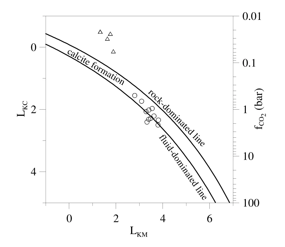
Fig. 5 Estimation of fugacity and reactivity of CO2 in hydrothermal systems on the basis of K,Mg and Ca concentration of geothermal water samplesLKM: The logarithm of the ratio of square potassium concentration to magnesium concentration;LKC: The logarithm of the ratio of square potassium concentration to calcium concentration.
4 Conclusions
The Banglazhang hydrothermal system of Longling region is characterized by much higher reservoir temperatures compared to the other nearby systems of Daheba, Dazhulin and Huangcaoba. The geothermal fluid in the deep reservoir of the Banglazhang system has a remarkably high temperature of up to 220 °C.However, due to different cooling processes during the ascent of this deep geothermal fluid, such as boiling and mixing with shallow cold waters, the Banglazhang geothermal waters in shallower reservoirs are marked by lower temperatures of around 150 °C as indicated by K-Mg and silica geothermometers. Nevertheless, the shallow geothermal fluids below Banglazhang are considered suitable for exploitation as a typical high-temperature hydrothermal resource.
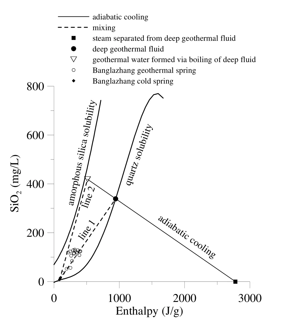
Fig. 6 SiO2 vs. enthalpy plot indicating secondary processes responsible for the formation of Banglazhang geothermal springs
Acknowledgements
This study was financially supported by the National Natural Science Foundation of China (No.41120124003, 41572335 and 41521001), the research program of China Power Investment Corporation (2015-138-HHS-KJ-X), and the research program of State Key Laboratory of Biogeology and Environmental Geology of China.
杂志排行
地下水科学与工程(英文版)的其它文章
- Compiling distribution of karst in Southern China and Southeast Asia
- Distribution of groundwater salinity and formation mechanism of fresh groundwater in an arid desert transition zone
- Study on the influencing factors of rock-soil thermophysical parameters in shallow geothermal energy
- Compilation of serial maps on karst geology of China and Southeast Asia
- Research on hydrogen and oxygen isotopes of paleoclimate reconstruction in Nuomuhong
