Relations between Mountain Settlements and Geographic Factors in Three Gorges Reservoir Area
2015-08-07LUOYong罗勇YUHui于慧WANGYong王勇ZHENGZhijun郑志军WANGXiao王晓
LUO Yong(罗勇),YU Hui(于慧),WANG Yong(王勇),ZHENG Zhi-jun(郑志军),WANG Xiao(王晓)
1 Key Laboratory of Geological Spatial information Technology ofMinistry of Land and Resource,Chengdu University of Technology,Chengdu 610059,China
2 The Institute of Mountain Hazards and Environment,Chinese Academy of Sciences,Chengdu 610041,China
3 Sichuan Institute of Land Planning and Survey,Chengdu 610031,China
4 The Geological EnvironmentMonitoring Station,Chengdu 610041,China
5 China Southwest Geotechnical Investigation&Design Institute Co.,Ltd.,Shanghai201206,China
Relations between Mountain Settlements and Geographic Factors in Three Gorges Reservoir Area
LUO Yong(罗勇)1,YU Hui(于慧)2*,WANG Yong(王勇)3,ZHENG Zhi-jun(郑志军)4,WANG Xiao(王晓)5
1 Key Laboratory of Geological Spatial information Technology ofMinistry of Land and Resource,Chengdu University of Technology,Chengdu 610059,China
2 The Institute of Mountain Hazards and Environment,Chinese Academy of Sciences,Chengdu 610041,China
3 Sichuan Institute of Land Planning and Survey,Chengdu 610031,China
4 The Geological EnvironmentMonitoring Station,Chengdu 610041,China
5 China Southwest Geotechnical Investigation&Design Institute Co.,Ltd.,Shanghai201206,China
Compared with previous studies,the research attempted to establish the appropriate quantitative models to explain the relations between settlement density Diand geographic factors,which could make a scientific guidance to the mountain settlements planning.Five factors,including slope,relief amplitude,distance to river,distance to cultivated land,and distance to road,were identified through principal com ponent analysis(PCA).The inherent relations between five factors and Di(settlement density) were modeled by regression analysis.The results are as follows.(1)The associations among Diand slope,relief am p litude,river,road are better modeled by the exponential decay line;with the buffer distance of slope,relief am p litude,distance to river and distance to road increasing,Didecreases.(2)The associations between Diand cultivated land are better modeled by the quadratic polynom ial line;with the buffer distance of cultivated land increasing,Diincreases first,and then dramatically decreases.(3)The area within 500 m from the road,within 500 m from the cultivated land,within 1 600 m from the river,within the relief am p litude of 30-200 m,and the area within the slope of 0°-10°are the fitting land for settlements,and it is very im portant to lay the mountain settlements on those optim ized regions.
three Gorges reservoir area;settlementaggregation degree; spatial distribution characteristic
Introduction
Recent studies have focused on the factors affecting the distribution of settlements that mainly related to natural environment(elevation,slope,river,road,etc.),social factors(like population,towns,and policy guidance),and economic factors(like GDP)[1-4].Many studies have been targeted at spatial characteristics[5-8]and spatial pattern of settlements[9-12],and the environment suitability evaluation of human settlement[13],as well as space evolvementmechanism of settlements[14].The spatial distribution of human settlements can exerta disproportionate influence on the environment[15]and indicate the impact of environment factors on human beings,which is fundamental to understand the relationship between human beings and their environments.Spatial analysis of settlement patterns has undergone revolutionary changes and become amodern research need[16-17].With the further research on the settlement,some scholars have quantitatively analyzed the relationships between settlements and geographic factors,such as topography,road,river,and the distance to town[3,18-19].It has been demonstrated that the spatial distribution of rural settlements is more heavily impacted by topography,access to water,arable land,and climatic parameters than urban areas[15,20].
Mountain communities are often“divided societies”[21],which have the accelerated changes brought by modernization. Mountain regions,compared with other types of areas,are still characterized by the strong community relationships[22]and geographic relationships.With the regional variations throughout Three Gorges reservoir area,the question has been of long-standing interest:what is the relationship between the mountain settlementand geographic factors?This study attempts to use several geographic factors to characterize the relationships between the mountain settlement and geographic factors,and establish the appropriate quantitative models to explain the relations between Diand geographic factors.
Compared with previous studies,the statistical unit of mountain settlements is based on space grid,and therefore mountain settlements could match well with geographic factors in space.But social factors and econom ic factors can'tmatch well with mountain settlements in space.So this paper only analyzes the relationship between the mountain settlements and the geographic factors.Combined with geoscience research method,the spatial analysis technique was applied to quantitatively analyzing spatial distribution of mountain settlements and the relationship between mountain settlements and geographic factors was analyzed by spatial regression model,and most important of all is that the research establishes the appropriate quantitative models to explain the relations between Diand geographic factorswhich would contribute to the optim ized layout of mountain settlements and make a great significance scientific guidance to the mountain settlements planning.The study results would provide an application example for the quantitative analysis.
1 Study Area
Three Gorges Reservoir Area Chongqing segment (105°49'E-110°12'E,28°31'N-31°44'N)is the transition zone from the eastern plains to the western hilly region of China.The Yangtze River runs through this region.The Three Gorges Reservoir Area is characterized by steep topography,deep valleys,rushing current,intensive surface exogenous erosion process,broken mountains,crossed gullies and fragile ecological environment[23].Chongqing segment in Three Gorges Reservoir Area,with the average temperature of 17-19℃,covers 15 counties inundated directly by Three Gorges Project(Fig.1).
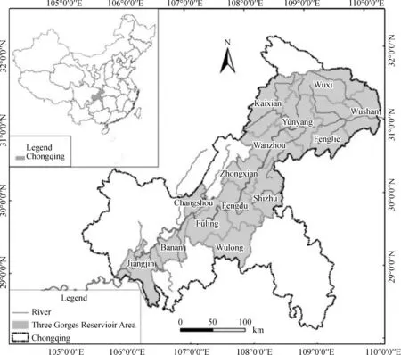
Fig.1 The study area of Three Gorges Reservoir Area(Chongqing segment)
2 Data and Method
The digital elevation model(DEM)data in this study referred to the Earth electronic topographic data ASTER GDEM with the basic grid cell size of30m×30m.The elevation and slope were derived from a DEM.The data of administrative boundary,road,river,cultivated land,and residential distribution were derived from Southwest Sub-center of National Remote Sensing Application Engineering Research Center in China with the basic scale of 1∶100 000.The data processing software included ArcGIS 9.3,SigmaPlot10.0,and SPSS 15.
The study area is located at the same climatic zones and latitude zone,so the geographic factors including elevation,slope,relief amplitude,distance to cultivated land,distance to river,and distance to road are selected to analyze the spatial distribution of settlements.The key factors(slope,relief amplitude,distance to cultivated land,distance to river,and distance to road)were identified by principal component analysis(PCA),accordingly.The relations between mountain settlements and the key factors were modeled by regression analyses.The detailed methods are summarized as follows.
To detect the spatial distribution pattern of mountain settlement and obtain the aggregation distribution between mountain settlement and geographic factors,the proportion of mountain settlement has been calculated in each region by a certain factor value,which can be represented as follows:

where Nsettlementis the number of mountain settlement(one cell size is 30 m×30 m)in a specific region.Di(settlement density)is the proportion of mountain settlement in a specific region.The proportion calculated in this way is used as a measurement of aggregation degree occurring within the buffer zone(Bi)defined by a certain factor value as follows.
First,buffer zone is made for geographic factors.For elevation factor,elevations are classified into 32 zones:0-200,200-300,300-400,400-500,500-600,…,2 800-2 900,2 900-3 000,and>3 000 m.For slope factor,slope gradients are classified into 11 zones,0°-5°,5°-10°,10°-15°,15°-20°,20°-25°,25°-30°,30°-35°,35°-40°,40°-45°,45°-50°,and 50°.For relief amplitude factor,it is classified into 6 zones:0-30,30-70,70-200,200-500,500-1 000,and>1 000m.For distance to cultivated land factor,buffer rings are created around cultivated land with 23 zones,using 0-100,100-200,200-300,300-400,400-500,500-600,…,1 400-1 500,and>1 500 m as the buffer zones.For distance to river factor,buffer rings are created around stream lineswith 33 zones,using 0-300,300-400,400-500,…,3 300-3 400,3 400-3 500,and>3 500 m as the buffer zones.For distance to road factor,buffer rings are created around road,using 0-100,100-200,200-300,300-400,400-500,…,2 700-2 800,and>2 800 m as the buffer zones.The distances to road are classified into 28 zones.
After that the area of each buffer zone(Bi)and the number of mountain settlement(Nsettlement)are calculated by spatial analysis provided by GIS.Based on Eq.(1),the proportion of mountain settlement in each buffer ring(Di)is counted and used to perform regression analysis between Diand geographic factors.
Considering the topography and geology in study area,six factors,including elevation,slope,relief amplitude,distance to cultivated land,distance to river,and distance to road were considered at first.At last,only slope,relief amplitude,distance to cultivated land,distance to river,and distance to road were determ ined as the key factors associated withmountain settlements by PCA.The regression models with higher R2value were identified in SigmaPlot 10.0.Then the appropriate models were established to explain the relations between Diand geographic factors.
3 Results and Discussion
3.1 Identification of key factors
The factors'extraction results in SPSS output file(Table 1,extraction method:principal component analysis)show that the cumulative contribution rate of the first four components cumulated to 84.22%which can presentmost of the original information.The eigenvalue variance of the first,the second,the third,and the fourth principal component are 31.67%,20.97%,16.29%,and 15.29%,respectively.

Table 1 Total variance explained
Table 2 shows that the slope and relief amplitudemade the greatest contribution to the firstprincipal component;distance to river,road,and cultivated land made the greatest contribution to the second,the third,and the fourth principal components,respectively.The rotated componentabsolute value of slope and relief amplitude in the first main component was the largest,indicating that slope and relief amplitude were the key factors affecting the distribution ofmountain settlement.

Table 2 Rotated componentmatrix
Based on the analysis on the action of all the six factors,five key factors including slope,relief amplitude,distance to river,distance to cultivated land,and distance to road were selected.Then,the relations between Diand the five key factors could be discussed accordingly(see the follow ing sections).
3.2 The aggregation distribute of mountain settlements in slope
In Fig.2,the proportion of Nsettlementin 0°-5°,5°-10°,and 10°-15°ismore than 15%.And 83.33%ofmountain settlement distributes at0°-15°,there into,43.27%ofwhich distributesat 0°-5°.As Zhang et al.[24]found that,88.11%of settlements distributed at0°-15°,there into,42.28%of which distributed at 0°-5°in the hilly and mountainous areas in Chongqing municipality.It show that the areas with better nature location and convenient farming conditions usually be chosen as rural residence.When the buffer ring of slope is greater than 10°-15°,Nsettlementoverlapping with the buffer rings of slope sharply declines.With the increasing of buffer distance,Nsettlementoverlapping with the buffer rings of slope decreases.This study further proved the conclusion that the slope had a significant impact on the spatial distribution of rural settlements[24].
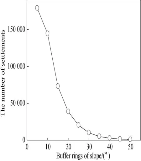
Fig.2 The distribution characteristic of mountain settlement on slope
Figure 3 illustrated the association between Diand slope (Eq.(2)).The regression analysis results in the follow model:

where S is the slope.The negative correlation between Diand S is significant(R2=0.994 7,n=11,t<0.000 1,a=-0.130 5).The correlation coefficient between Diand S is-0.778.Diis the largestwithin the slope of 5°and its value is 43.27 N/km2.When the slope is greater than 15°,Disharply declines.When the slope is greater than 25°,Diis less than 3 N/km2.So with the increasing of slope,Didecreases.

Fig.3 Simulation curve of Diand slope
3.3 The aggregation distribute of mountain settlements in relief amp litude
In Fig.4,the proportion of Nsettlementin the relief amplitude of 30-70 m is the largestand its value is39.59%.And 96.47% ofmountain settlements distributes at the relief amplitude of 0-200 m,there into,76.87%of which distributes at the relief amplitude of 30-200 m.When the buffer rings of relief amplitude is greater than 200 m,Nsettlementoverlapping with the buffer rings of relief amplitudesharply declines.Zhang et al.[25]demonstrated that rural settlements decreased with the increase of relief amplitude in karst trough valley of Chongqing.In fact,with the increasing of buffer distance,Nsettlementoverlapping with the buffer ring of relief amplitude increases first,and then decreases in the Three Gorges Reservoir Area.As the stream channel distributing at the low relief amplitude region usually,themountain settlements distributing at the relief amplitude of 0-30 m is lower than that of 30-200 m.

Fig.4 The distribution characteristic of mountain settlement on relief amplitude
Figure 5 illustrates the association between Di(Eq.(3)) and relief amplitude.The regression analysis results in the follow model:

where Rais the relief amplitude.The negative correlation between Diand Rais significant(R2=0.991 3,n=6,t<0.000 1,a=-0.014 3).The correlation coefficient between Diand Rais-1.000.Diis the largestwithin the relief amplitude of 0-30 m and its value is 53.84 N/km2.Diis only 7.70 N/ km2within the relief amplitude of 70-200 m.When the relief amplitude is greater than 70 m,Disharply declines.So with the increasing of relief amplitude,Didecreases.The mountain settlementsmainly distribute at the relief amplitudewithin 70m.

Fig.5 Simulation curve of Diand relief amplitude
3.4 The aggregation distribute of mountain settlements in road
In Fig.6,the proportion of Nsettlementin the buffer ring of100 m is the largest and its value is 15.34%.And 87.42%of mountain settlements distributes at the area within 1 000 m from the road,there into,61.58%of which distributes at the area within 500m from the road.When the distance is over 1 500m away from road,Nsettlementoverlappingwith the buffer ring of road sharply declines and the proportion of Nsettlementis less than 0. 88%.So with the increasing of buffer distance,Nsettlementoverlapping with the buffer ring of road decreases.The rural settlements decrease as the distance to road increasing[26-27].The area near the road is convenient for working[28].
Figure 7 illustrates the association between Di(Eq.(4)) and road.The regression analysis results in the follow model:

where Droadis the distance to road.There is a significant negative correlation between Diand Droad(R2=0.987 8,n= 28,t<0.000 1,a=-0.000 9).The correlation coefficient between Diand Droadis-0.958.D is the largestwithin 0-100 m from the road with 18.39 N/km2(Fig.7).When the distance is over 1 500 m away from road,Didramatically decreases.Diis only 5.60 N/km2within the buffer rings of 1 500-1 600 m. With the increasing of buffer distance,Dioverlapping with the buffer rings of road decreases.
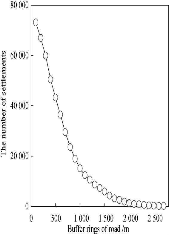
Fig.6 The distribution characteristic ofmountain settlement on road

Fig.7 Simulation curve of Diand road
3.5 The aggregation distribute of mountain settlements in cultivated land
In Fig.8,the proportion of Nsettlementin the buffer ring of 100 m is largest and its value is 38.05%.And 94.42%of mountain settlements distributes atthe area within 1 000 m from the cultivated land,there into,79.65%of which distributes atthe area within 500 m from the cultivated land.When the distance is over 1000 m away from cultivated land,Nsettlementoverlapping with the buffer rings of cultivated land sharply declines and the proportion of Nsettlementis less than 1.40%.The cultivated land is one of the important source for rural residents' living[27].So the rural settlementsmainly distribute at the area near the cultivated land.with the increasing of buffer distance,Nsettlementoverlapping with the buffer ring of cultivated land decreases.
Figure 9 illustrates the association between Di(Eq.(5)) and cultivated land.The regression analysis results in the follow model:
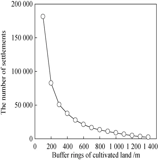
Fig.8 The distribution characteristic of mountain settlement on cultivated land

where Clandis the distance to cultivated land.There is a significant correlation between Diand Cland(R2=0.878 4,n= 23,t<0.000 1,a=-0.335 2).The correlation coefficient between Diand Clandis0.538.In Fig.9,Diis the largestwithin 900-1 000m from the cultivated land with 32.39 N/km2.With the increasing of buffer distance,Dioverlapping with the buffer rings of cultivated land increases first,and then dramatically decreases.

Fig.9 Simulation curve of Diand cultivated land
3.6 The aggregation distribute of mountain settlements in river
In Fig.10,Nsettlementproportion of 300 m is the largest and its value is 21.26%.And 74.12%of mountain settlements distributes at the area within 1 600 m from the river.When the distance is over 1 600 m away from river,Nsettlementoverlapping with the buffer ring of river sharply declines and the proportion of Nsettlementis less than 1.83%.Zhu etal.[28]demonstrated that the rural settlementsmainly distributed at the area near the river in the range of 500 to 1 500 m.So with the increasing of buffer distance,Nsettlementoverlapping with the buffer rings of river decreases.The rural settlements decreases as the distance to river increases[27-28].The area near the river is convenient for getting the domestic water and agriculturalwater.
Figure 11 illustrates the association between Di(Eq.(6)) and river.The regression analysis results in the follow ing model:

where Driveris the distance to river.There is a significant negative correlation between Diand Driver(R2=0.959 8,n= 33,t<0.000 1,a=-0.000 8).The correlation coefficient between Diand Driveris-0.957.In Fig.11,Diismore than 25 N/km2within the buffer ring of 1 000 m from the river.Diis the largestwithin 300-400 m from the river with 43.57 N/ km2.When the distance is over 2 000 m away from river,Didramatically decreases.Diis only 9.41 N/km2at2 000-2 100 m from river.Rural settlements mainly distribute at the area within 300-400 m from the river.Not only does the area have the richness cultivated land and the convenient transportation,but also the flat terrain which is convenient for working and getting the domestic water and agricultural water.Compared with the buffer near the river,the area within 300-400 m from the river is less susceptible to be threatened by the floods and other natural disasters in the rainy season.

Fig.10 The distribution characteristic of mountain settlement on river

Fig.11 Simulation curve of Diand river
4 Conclusions
Calculating themountain settlements in the zone defined by the value range of a certain geography factor is an effective method to reflect the settlements'aggregation degree.It is an effective attempt to calculate the relationship between the mountain settlements and geographic factors by regression analysis in the Three Gorges Reservoir Area.In this paper,the appropriate quantitative models were established to explain the relations between Diand geographic factors.There was a strong nonlinear negative correlation between Diand slope,relief amplitude,distance to river and distance to road.With the increasing of geographic factorsmentioned above,Digradually decreases.The associations between Diand cultivated land arebetter modeled by the quadratic polynomial line.With the increasing of buffer distance of cultivated land,Diincreases first,and then dramatically decreases.The appropriate quantitative models can predict the relationship between the mountain settlements and geographic factors.
In ecologically fragile areas of Three Gorges Reservoir Rrea,the main transport network and cultivated land are basically along the river.At the same time,water and traffic conditions play an important role on the mountain settlements. According to the above analyses and calculations,most of the mountain settlements distribute at the areas near river and road,especially the area within 500 m from the road,within 500 m from the cultivated land,within 1 600 m from the river,within the relief amplitude of 30-200 m,and the area within the slope of 0°-10°.These areas are the fitting land for settlements to keep a high safety level,and it is very important to lay the mountain settlements on those optimized regions.
The lessons from selection of resettlement areas after the“5·12”earthquake in 2008 are painful.The“8·13”catastrophic debris flow in 2010 buried and destroyed a considerable number of“5·12”post-earthquake resident settlement areas in the valley area in Qingping Town[29].From that we can see the scientific selection of the fitting land for settlement construction is very important,especially in the mountain area.Since the geographical environment restricts human activities in a narrow space,themountain settlements are generally distributed at the area near the river,transportation network and cultivated land with lower relief amplitude and slope.Therefore,the research identified the fitting land for settlements and the appropriate quantitativemodels,which could provide a scientific basis for the correct analysis of mountain settlements'spatial distribution and safety level and make a scientific guidance to themountain settlements planning that where is the better area for settlement construction.During rapid urbanization,emphasis should be laid on the assessmentofmountain settlements'safety level,and the relationship between the mountain settlements and geographic factors should be paid special attention to.
[1]Liu M H,Dai Z Z,Qiu D C,etal.Influencing Factors Analysis and Rational Distribution on Rural Settlements in Montains Region[J].Economic Geography,2011,31(3):476-482.(in Chinese)
[2]Zhao W,Shen W S,Zou C X,et al.Affect on the Distribution of Residential Points in the Source Region of the Yarlung Tsangpo River[J].Journal of Mountain Science,2012,30(6):728-736.(in Chinese)
[3]Jiao B B,Shi P J,Liu C F,et al.The Distribution of Rural Settlements in Relation to Land Form Factors in Low Hilly Land on the Loess Plateau[J].Resources Science,2013,35(8): 1719-1727.(in Chinese)
[4]Feng C C,Zhao R X,Gu W Y.Study on the Social Econom ic Factors of the Land Use Changes in Rural Residential Areas of China[J].China Population,Resources and Environment,2012,22(3):6-12.(in Chinese)
[5]Yu M,Li JD.Analysis on Landscape Pattern Based on RS and GIS in Huanren County[J].Geomatica&Spatial Information Technology,2005,28(5):50-54.(in Chinese)
[6]Tian G J,Liu J Y,Zhang Z X.The Scale Distribution Characteristics of Chinese Rural Settlements by Remote Sensing and GIS[J].Journal of Remote Sensing,2002,6(4):307-312. (in Chinese)
[7]Li Y Q,QiW,Wang D,et al.Research on Spatial Distribution Characteristics of Rural Settlements in Mountainous Areas at County Level Based on GIS:a Case Study in Qixia City[J]. Geography and Geo-Information Science,2011,27(3):73-77. (in Chinese)
[8]Wang Q,ShiM Q,Guo Y L,etal.The Vertical Differentiation of the Mountain Settlement Niche in the Upper Reaches of M injiang River[J].Acta Geographica Sinica,2013,68(11): 1559-1567.(in Chinese)
[9]Marjanne S,Marc A.Settlement Models,Land Use and Visibility in Rural Landscapes:Two Case Studies in Greece[J]. Landscape and Urban Planning,2007,80(4):362-374.
[10]Feng W L,Li A N,Zhou W C.Spatial Pattern of Rural Settlements in the Upper Reaches of the M ingjiang River:a Case Study in Maoxian County,Sichuan[J].Journal of Mountain Science,2007,4(2):146-154.(in Chinese)
[11]Lo C P.Settlement,Population and Land Use Analysis of the North China Plain Using Shuttle Imaging Radar-a Data[J].The Professional Geographer,1986,38(2):141-149.
[12]Tian G J,Yang Z F,Zhang Y Q.The Spatio-Temporal Dynam ic Pattern of Rural Residential Land in China in the 1990s Using Landsat TM Images and GIS[J].Environmental Management,2007,40(5):803-813.
[13]Zhu L,Wu B F,Zhang L.Research on the Landscape of Rural Residential Areas and Human Settlement Environment Suitability Evaluation in Three Gorges Typical Regions[J].Resources and Environment in the Yangtze Basin,2011,20(3):325-331.(in Chinese)
[14]Luo G J,LiY B,Wang S J.Analysisof Settlements Distribution Pattern and Changes in Karst Mountainous Area—Taking the HouzhaiWatershed Region in Pudin County as an Example[J]. Resources and Environment in the Yangtze Basin,2010,19(7): 802-807.(in Chinese)
[15]Tian G J,Qiao Z,Zhang Y Q.The Investigation of Relationship between Rural Settlement Density,Size,Spatial Distribution and Its Geophysical Parameters of China Using Landsat TM Images[J].Ecological Modelling,2012,231:25-36.
[16]Richard F.Some Spatial Analyses of Chalcolithic Settlement in Southern Israel[J].Journal of Archaeological Science,2008,35 (7):2048-2058.
[17]McKenzie P,Cooper A,McCann T,et al.The Ecological Impact of Rural Building on Habitats in an Agricultural Landscape[J].Landscape and Urban Planning,2011,101(3):262-268.
[18]Zhang J,Ni S X,Liu Y,et al.A Quantative Study on the Spatial Distribution Pattern of Human Settlement in Three River Paralleled Running Region[J].Journal of Mountain Science,2003,21(1):121-125.(in Chinese)
[19]Jiang G H,Zhang F R,Qin J,et al.Relationship between Distribution Changes of Rural Residential Land and Environment in Mountainous Areas of Beijing[J].Transactions of the CSAE,2006,22(11):85-92.(in Chinese)
[20]Small C.Global Population Distribution and Urban Land Use in Geophysical Parameter Space[J].Earth Interactions,2004,8 (8):1-18.
[21]Osti G.Leader and Partnerships:the Case of Italy[J]. Sociologia Ruralis,2000,40(2):172-180.
[22]Magnani N,Struffi L.Translation Sociology and Social Capital in Rural Development Initiatives—a Case Study from the Italian Alps[J].Journal of Rural Studies,2009,25(2):231-238.
[23]Wang Y,Liu H B,Wu W,et al.Quantitative Morphologic Analysis of the Three Gorges Region Based on GIS[J].Science of Surveying and Mapping,2006,31(2):93-95.(in Chinese)
[24]Zhang X,Wei C F,Ni J P,et al.Distribution Patterns and Influence Factors of Rural Settlements in the Hilly and Mountainous Areas in Chongqing Municipality[J].Chinese Joural of Agricultural Resources and Regional Planning,2012,33(3):45-50.(in Chinese)
[25]Zhang X,Wei C F,Ni JP,et al.Research on the Distribution of Rural Settlements in Relation to Landform Factors in Karst Trough Valley of Chongqing Municipality[J].Carsologica Sinica,2012,31(1):59-66.(in Chinese)
[26]Liu X Y,Tian Y Z,Lin S,etal.Distribution Characteristicsand Driving Force Analysis for Rural Residential in the Three Gorges Reservoir Area Based on GIS:a Case Study of Fuling District,Chongqing[J].Hubei Agricultural Science,2013,52(8): 1800-1805.(in Chinese)
[27]Guo Y T,Liao H P,Xu JG.Evaluation on Suitability of Rural Residential Land in Three Gorges Reservoir Region[J]. Transactions of the Chinese Society of Agricultural Engineering,2012,28(5):252-259.(in Chinese)
[28]Zhu L,Wu B F,Zhang L.Research on the Landscape of Rural Residential Areas and Human Settlement Environment Suitability Evaluation in Three Gorges Typical Regions[J].Resources and Envirionment in the Yangtze Basin,2011,20(3):325-331.(in Chinese)
[29]Yu H,Liu S Q,Guo S L,et al.The Impact of Catastrophic Natural Disaster on Land-Use Changes of Qingping Town and the Selection of Suitable Land for Settlement Construction[J]. Journal of Mountain Science,2012,9(6):827-834.(in Chinese)
K901.8
A
1672-5220(2015)04-0571-06
date:2014-02-22
s:National Natural Science Foundation of China(No.41101552);West Light Foundation of the Chinese Academy of Sciences (No.2013);Geographic National Condition Monitoring Engineering Research Center of Sichuan Province,China(No.GC201418);Key Laboratory of Geo-spatial Information Technology of M inistry of Land and ResourcesOpen Fund,Chengdu University of Technology,China(No. KLGSIT2015-08)
*Correspondence should be addressed to YU Hui,E-mail:yuhui@imde.ac.cn
猜你喜欢
杂志排行

Journal of Donghua University(English Edition)的其它文章
- Empirical Analysis of Binary Logistic Model for the Influencing Factors of the Chinese Urban and Rural Residents'Woolen Products Consumption—Based on Questionnaires of 513 Urban and Rural Residents in 16 Provinces
- Analysis of Satisfaction with Business Cost in Shanghai Using Structural Equation Modeling Approach
- Ontology Mapping Based on Bayesian Network
- Diurnal and Seasonal Variations in Particulate Matter at Shanghai during the Heavy Haze and Non-haze Periods
- Swept-Volume Display System Based on Cylindrical Space Projection and Curved Reflectors
- Existence of Solutions for Infinity-Point Nonlinear Fractional Boundary Value Problem at Resonance