Stability assessment and risk analysis of aboveground river in lower Yellow River
2014-11-26SHIJianshengLIUChangliDONGHuaYANZhenpengWANGYanjunLIUXinhaoGUOXiuyanJIAOHongjunYINMiyingHOUHuairen
SHI Jian-sheng, LIU Chang-li*, DONG Hua, YAN Zhen-peng, WANG Yan-jun, LIU Xin-hao, GUO Xiu-yan, JIAO Hong-jun, YIN Mi-ying, HOU Huai-ren
1 Institute of Hydrogeology and Environmental Geology, CAGS, Shijiazhuang 050061, China.
2 Henan Institute of Geological Survey, Zhengzhou, China.
3 Shandong Institute of Geological Survey, Jinan, China.
Abstract: Although the Chinese people have, through continuous efforts, built the constantly improving Yellow River flood control system, and created a miracle which has been tranquil for over 50 years, the tendency for the downstream watercourse of the Yellow River to uplift every year has not been fundamentally curbed, and the aboveground river is still the “scourge”of the sons and daughters of the Yellow River. By the use of a variety of modern investigation and survey methods, the geological environment characteristics of the downstream of the Yellow River have been identified basically, including the environmental and geological factors affecting the stability of aboveground rivercourse of the lower Yellow River such as the active fracture of the lower Yellow River, crustal uplift, land subsidence, seismic activity, geological conditions of dike foundation engineering, hydrodynamic conditions of rivers, and geomorphology of watercourses. After a comprehensive analysis of the inability mode of aboveground river on the downstream of the Yellow River and its corresponding impact factors, by using the fuzzy comprehensive evaluation method, we have evaluated the crustal stability of the aboveground river, dike foundation stability, watercourse landform stability and overall stability. The results of comprehensive results show that the stability of downstream aboveground rivercourse of the Yellow River can be divided into four grades and 11 sections, i e. “basically stable, unstable, very unstable and extremely unstable”. On the basis of the stability segmentation, we consider the influence of integrally the future structural faults,earthquakes, the difference of watercourse between forward and backward heights of dikes,river regime and river type, historical crevasses, foundation soil liquefaction and seepage deformation, and find out 17 most unstable danger points. Finally, from 17 danger points, we select 7 danger points which are most prone to instability including Wuzhi, Zhongmou,Kaifeng, Fengqiu, Dongming, Changyuan and Dong'e. The calculation and analysis of the range and area inundated by 7 danger points, area, and number of people threatened, possible economic loss, and environmental damage, the inability caused by any one of 7 points could bring disastrous consequences to the downstream.
Keywords: Lower Yellow River; Geological environmental characteristics; Aboveground rivercourse; Stability evaluation; Risk analysis
Introduction
The Yellow River, the second longest river of China, originates from the foot of Bayankala Mountain of China, flows through Qinghai,Ningxia, Shanxi, Shaanxi, Henan and other provinces (regions) of China, and finally empties into the Bohai Sea in Shandong Province, with a total length of 5 464 km (CHEN Qi-wei et al.1998). Although the Yellow River, the mother river of the Chinese nation, nourishes its children,it's downstream (Henan Province, and a section within Shandong Province) suffers periodic flooding, crevasse and diversion, also bringing disaster to the people along the river. A huge amount of silt generated from soil erosion upstream is carried into the downstream of the river, and fills up in the river siltation, so that the riverbed elevates every year and an “aboveground river” above the ground on both sides of the river is formed. The degree of the aboveground river is usually 3-5 m, and even up to 10 m (CHEN Qi-wei et al. 1998; YE Qing-chao et al. 1997). This state of aboveground river often brings severe flooding in flood season, and once the dike bursts, flood condescends, and flows down vigorously, causing very serious disaster. This phenomenon of the Yellow River is called diversion. Since recorded history, in the lower Yellow River, there were more than 1 500 dike breaching, 26 diversions including 5 large diversions (CHEN Qi-wei et al.1998). After Liberation, the Chinese government put huge investment by continuously building a flood control system, creating a tranquil of 50 years as miracle, but the river is still hanging suspended in the heart of the nation “scourge”.
Aboveground river stability can be defined as the ability to maintain the safe transport of water and sand of the aboveground river watercourse.When this ability is lost, the aboveground river will be unstable-during the flood, aboveground river dike loses stability, or dikes are damaged or overflow occurs, causing flooding, which inundates the residents on both sides of the aboveground river, bringing disaster to the people's lives and property. Evaluation of the stability of the existing downstream aboveground of the Yellow River and analysis of its risk are of particularly significance to the development and management of the Yellow River.
1 Results of environmental geological survey of Yellow River
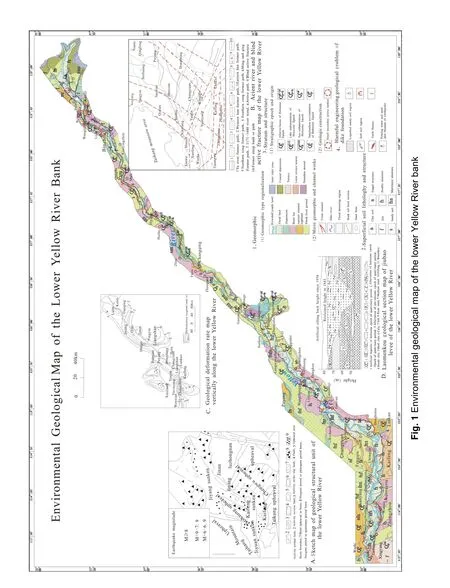
To identify the issues about geological stability of aboveground river, the Institute of Hydrogeology and Environmental Geology, CAGS,together with Henan Institute of Geological Survey and Shandong Institute of Geological Survey,jointly launched the “Survey and Evaluation of Stability of Aboveground River of Lower Yellow River”. On the basis of systematic and integrated study of existing data, in combination with the regional geological features in relation to aboveground river stability, new tectonic movement and watercourse geology and geomorphology, we centered on remote sensing technology and ground environmental geological survey, focused on dissection by combining with typical sections,carried out 1/50 000 and 1/100 000 remote sensing interpretation, and 1/50 000 environmental geological survey used geophysical prospecting,geochemical prospecting, geological drilling,testing and other survey means. We basically ascertained the environmental geological characteristics of the lower Yellow River watercourse and various factors affecting the stability of the downstream aboveground river, with the survey results shown in the environmental geological map of the lower Yellow River watercourses (Fig. 1).
2 Analysis on stability factors of aboveground river in lower reaches of the Yellow River
According to the survey and research, the stability of the aboveground river on the lower Yellow River is determined by stability of downstream crust, stability of aboveground river dike and stability of watercourse. The factors affecting the three elements are the factors affecting the stability of downstream aboveground river (Institute of Hydrogeology and Environmental Geology, CAGS et al. 2003; HUANGPU Xing-feng et al. 2003). They are analyzed as follows one by one.


2.1 Factors affecting the stability of lower Yellow River crust
2.1.1 Active faults
(1) Geological activity fault control mechanism of stability of existing watercourse.
Fig. 2 and Fig. 1A are the current maps of the lower Yellow River geological structure and distribution of active faults (Institute of Hydrogeology and Environmental Geology, CAGS et al.2003; YE Qing-chao et al. 1997). As for the current paths of the lower Yellow River, except that the section from Gengshan, Shandong, to Jiyang, passes through Southern Center of Shandong, the rest reaches go through rift zones.The passing tectonic zone goes into Kaifeng depression from the east of Taohuayu, deflects to northeast after reaching Dongbatou, goes through Heze uplift and Liangshan rift trough at Gaocun Village, and then passes through Taishan uplift, to Jiyang into the depression and into the Bohai Sea,with the flow path of 786 km, drop of 94 m, and average gradient of 0.012%. However, in the zone where the river passes, there are many faults, and 7 major faults pass through Yellow River alone,including the NNE deep fault in front of Taihang Mountain, Liaolan major fault, and Yushang major fault; EW major fault north of Taishan uplift,Xinshang major fault and Zhengzhi major fault.
(2) Buried active faults controlling the strike of downstream aboveground river watercourse.
According to relevant studies (Institute of Hydrogeology and Environmental Geology, CAGS et al. 2003; HUANGPU Xing-feng et al. 2003; YE Qing-chao et al. 1997) buried active tectonics may control the specific strike of Yellow River watercourse (Fig. 1B) and deposition border, faults crossing the river or fault intersections control the important burst points in history. The active nature of both sides of the fault can also experience reverse changes, along the strike, and thus create a corresponding impact on the river trend or burst.Zhengzhou-Lankao fault, nearly EW, one of Jiyuan-Kaifeng depression south edge ultracrustal faults, controls the flow direction of Yellow River out of the mountains after the Holocene, plus the tilting action of Taihang Mountains to the south,causing it to scroll to the south. Laoyachen fault and vicinity of Baimaquan intersecting with the left bank, Huayuankou fault and vicinity of Huayuankou intersecting with the Yellow River,intersection point of Liaolan fault and Xinxiang -Shangqiu fault, Liaolan fault and vicinity of Dongkou intersecting with the Yellow River are all historically important burst points. As seen from the distraction direction of the Lower Yellow River,all trends of its reaches are related to the new tectonic movement (Fig. 1A and Fig. 2).
Except for Fan County-Jinan reach of the Yellow River passing through Luxi platform uprise,other reaches run basically along Jiyuan-Kaifeng depression, Dongming rift, and the settlement center zone of Jiyang depression with large sedimentation rate (Fig. 1A and Fig. 2). Throughout the thickness of sediments of the lower Yellow River, the thickness of the recessed area is much larger than that of the raised area, indicating that the tectonic movement controls the running range to some extent. Therefore, the cooperation of subsidence zone with strong tectonic movement or developed consequent active fault and the central zone of resultant depression or graben with active faults decides on the running range in each historical period.
(3) Damage of active faults passing through Yellow River to stability of dike engineering foundation.
Six deep and major faults across the Yellow River, i e. F1, F2, F3, F4, F5 and F6 in Fig. 2, have been active since the Cenozoic (YE Qing-chao et al. 1997). Fault abrupt events generate strong earthquakes and lead to ground fracturing and subsidence, water spray and sand inrush, causing damage to dike engineering.
(4) Fault gradient events.
Deep and major faults of lower Yellow River across and near the Yellow River first occur to the deep crust, with the passage of time and multiple inheritance activities, gradually extend to the surface, forming ground fissures, and affecting dike stability.
The burst points on the Yellow River dike,especially the locations with densely distributed burst points, are related to active faults across Yellow River, for example, Zhengzhou Baohezhai and Wuzhi Erpuying opposite to Beixi, Zhongmou Wantan-Jiubao and Yuanyang Taiping Town across the river, Kaifeng Mazhuang and Fengqiu Jinglonggong across the river and Lankao Dongbatou are locations of active faults across the Yellow River and also burst-prone areas of Yellow River historically (Fig. 1). Since the recorded time,four large natural diversions of the Yellow River are all located on the intersection of major faults with derived faults or compressive-shear fault zones (Fig. 1A and Fig. 2). This illustrates the devastation caused by fault activities to the stability of ancient watercourses.
2.1.2 Crust uplift effect on the stability of aboveground river.
(1) Effect of Luzhongnan uplift on the stability of the watercourse
The Yellow River, at Gengshankou, separates from Liangshan rift trough ground and passes through Luzhongnan uplift, and therefore the river suddenly shrinks, only 400-500 m wide, with large bending degree, turning into a bending river (Fig.1A). Thus, the Yellow River water discharge drops,with drainage capacity greatly reduced, becoming a bayonet reach. The potential threat of the reach posed to the stability of the river can not be ignored.
(2) Retardation of active uplift of Jining Chengwu on river sediment transport.
Bounded by Gaocun Village, to the west is Kaifeng and Dongming fault depression with strong settlement, and the east of downstream is relatively raised Jining Chengwu Lift (Fig. 1A).The absolute value of recent vertical uniform crustal deformation rate is 9 mm/a, and thus its vertical differential lift is very strong. Differential lift movement causes the change to the river shape,with Gaocun Village as a turning point, the reach above it is shallow and scattered, as a wandering wide river. At the reach below it, the river contracts with more corners, and turns into a bending river.
According to the changes to shapes of the river above and below the Gaocun River and analysis of characteristics of silt sedimentation, due to blockade of active uplift of Jining Chengwu,sediment transport capacity of the river is greatly weakened, and thus most of coarse sediment deposits in wide reaches of the river, increasing the difference of aboveground river. The reach of this adverse geological structure results in an extremely adverse effect on the stability of the river.
2.1.3 Impact of land subsidence
Recent and modern settlement centers decide the range of downstream river running. At the geological time and historical period, the Yellow River runs mostly along the depression centers.Since recorded history, the North-East running time is much greater than South-East running time,because northern section of the North China Depression has higher sedimentation rate than the southern section (Fig. 1C), with a larger settlement rate, and favorable to sediment transport; on the contrary, not conducive to the stability of the aboveground river.
2.1.4 Influence of seismic activities on the stability of aboveground river
An abrupt change means a disaster, and is expressed as a seismic activity. In downstream areas of the Yellow River, destructive earthquake above Intensity VI has taken place several times(since recorded history), and most of earthquakes are related to the aforementioned active fault. The epicenter is located at the intersection of the faults,fault zones or vicinities, and earthquake causes greater damage to the downstream watercourses of the Yellow River (Fig. 1A and Fig. 2).
Heze Earthquake, Intensity VII, occurred in August 1, 1937, with the epicenter located on the NW compressive-shear fault zone of southern section of Liaolan fault. The earthquake spread to Dongming-Jiucheng section of the Yellow River dike, with the seismic Intensity Ⅶ , and sand boiling was seen in the foots of river walls of the dikes in Gaocun, Lengzhai, Xiangzhai and Huangzhuang during the earthquake, with a crack of 20-30 cm wide, and 200 m long in the dike foot of Gaocun.
Bohai earthquake, Intensity 7.4, occurred on July 18, 1969, with the epicenter located at the instersection of Yishu fault and NE Bohai fault,and the focal depth of 40-50 km. Ground fracturing,subsidence and gushing were discovered in Kenli and Lijin on the lower Yellow River, with ground fissures of 0.5-3 km long, and 10-50 cm wide,which were densely distributed into a band, and serious damages such as cracking, slumping and subsidence were found on the dike of estuary of the Yellow River.
2.2 Factors influencing the stability of downstream aboveground river dike
2.2.1 Impact of adverse soil of dike on stability of aboveground river
The downstream area of Yellow River is an alluvial plain, with soft formations, the lithology within 20 m under the dike is mainly new silty soil,and fine sand, contains a thin layer of clay or silty clay, with more clayey soil below Gaocun. The reaches Wuzhi Baimaquan, Zhengzhou-Kaifeng,and Lankao Dongbatou are mostly of fine sand and silt, with loose soil. On the outside of the dikes of Yellow River there are more lying lands, the burial depth of water table is shallow, 4-6 m for some sections, and less than 3 m generally. The upper reaches of Taochengpu are mostly areas of earthquake intensity VII, saturated fine sand and silt distributed near the dike are easy to produce liquid in the event of a strong earthquake, cause ground water-gushing and sand-emitting, ground cracking, and damage to the dike and especially water-gushing and sand-emitting near the dike foot is more dangerous (Fig. 1).
Loose fine sand and silt distributed around the dike have strong permeability, during the great flood, the high water level difference inside and outside the bank can easily lead to significant adverse geological phenomena such as dike body and dike angle seepage, piping and soil flow,resulting in the dike outburst (Fig. 1).
2.2.2 Crevasse distribution in history
Existing watercourse of Yellow River suffers frequent bursts in history, and most of the entrances are concealed under the current dike,becoming a great risk to the dike works. When the dike bursts, the materials used in closure are mostly sediment, branches and stones take from nearby, the filling oil in these closures are complicated in ingredients, having large porosity,coupled with rot of stalks and twigs, causing the higher water seepage in the entrance. The entrance of Zhongmou Jiubao dike was created by the breach in 1843, with a larger scale, and now has been buried beneath the dike. The fill in the entrance has the thickness of nearly 40 m, which contains a large amount of straw material (Fig.1D).
In Dongbatou-Gaocun Village, Dongkou-Sunkou Section, Taochengfu-Luokou Section, and lower reach of Binzhou, the dike and surrounding are distributed with silty soil, most of which are marsh sediments, affecting the stability of dike foundation (Fig. 1).
2.2.3 Influence of soil structure in river on the stability of aboveground river
Shallow and loose soil along the Yellow River,especially soil structure and lithology in the river stability is closely related to the stability of the river. Lithology composition of the shallow and loose soil is mostly silt material, with strong permeability. The soil body of upper reach of Gaocun Village, along the shallow part of the Yellow River is mainly sand and silt double-layer structure and silt and sand-based multi-layer stacked structure type, while in the lower reach of Qucun Village, silt and clay soil mixed and stacked structure has the higher chance of occurrence. The bed material in the downstream of river becomes fine from coarse from Taohuayu-estuary (Fig. 1).When the bed material and floodplain lithology is mainly composed of sand and silt, its anti-erosion ability is poor, it is susceptible to deformation and reshaping due to erosion, threatening the dike safety. Moreover, due to the high permeability,under the impact of high water level difference inside and outside the dike, the sand and silt may suffer seepage deformation, resulting in damage to the dike.
2.3 Influence factors of river course of aboveground river downstream
2.3.1 Influence of topographic feature of river course on stability of aboveground river
Geomorphic system in the lower Yellow River is mainly divided into riverbed, flood plain, two system of dike as well as affiliated geomorphic system. The riverbed is the transport watercourse of flow and sediment and also the main watercourse for large flood, with river islands and marginal banks scattered on it. There is a first-level flood plain developed above the eastern abutment in the lower Yellow River and a first-level flood plain developed below it. The leading edge of the flood plain is generally high with flat beach face,there are longitudinal and transverse river slopes downstream and at backside of the river, the longitudinal river slope is identical to the riverbed and the traverse gradient is generally 0.02%-0.05%, erosion ditch and semi-natural dike are scattered on it. These flood plains, river islands and marginal banks on the river course have changed the dynamic effect of the river and influenced the stability of aboveground river (Fig.1).
Dike is the boundary of topographic feature of river which belongs to artificial topographic feature (Fig. 1). Under the constraint of dikes on both sides of river course, it is influenced actively by river siltation which causes modern topographic feature of aboveground river. The Yellow River dike plays a decisive role in flood control and disaster reduction and prolonging life of river course meanwhile intensifies the occurrence and development of unstable factors of river course due to the continuous increase of dike.
Affiliated geomorphic system of the river includes crevasse splay deposits in marsh land at backside of the river and detention depression besides the dike (Fig. 1). Taohuayu-Gaocun section in the lower Yellow River belongs to wandering wide section, the river course is wide and shallow and it is the largest section in perched difference. Due to strong deposit of wide section and effect of natural dike of flood plain, and reduction of the opportunity of sediments on the beach because of existence of production dike,there are some factors occurring in wide section such as oblique river and right-angled river not conducive to the stability of the river course.
Micro topographic features in river course mainly include erosion ditch, depressions abutting the river, semi-natural dikes, production dikes as well as eroding banks (Fig. 1), these micro topographic features are the main factors influencing the stability of aboveground river. It not only affects river washing and deposit but is the incentive to formation of river watercourse swinging, right-angled river, oblique river, causing burst to weak sections by carelessness.
2.3.2 Influence of dynamic geological process of rivers on stability of aboveground river
Influence of river dynamic geological process is a kind of external geological force, river dynamic geological process at the lower Yellow River mainly includes sedimentation, erosion as well as seepage suffosion. Powerful sedimentation downstream not only forms North China Plain but molds aboveground river topographic feature on the plain at present, under the constraint of Yellow River dike, the positive effect increases the riverbed continuously which accelerates the shrink of river course and reduction in amount of flood passage, influencing the stability of aboveground river.
The Yellow River course downstream also has discontinuous wash. The wash makes change of river regime and bank slump downstream. Seepage suffusion would occur in flood in dike under the promotion of high suspension potential difference during the flood period, its result could cause leakage and piping effect to lead to breakage to the bank. Once the water rewashes the riverbed, the opportunity of right-angled river and oblique river increases greatly, threatening the dike security seriously.
3 Stability evaluation of aboveground river of lower Yellow River
3.1 Mode of instability of aboveground river and its key influence factors
According to the preliminary statistics(Institute of Hydrogeology and Environmental Geology, CAGS et al. 2003), since 2600 years BC,the downstream dams of the Yellow River has already burst 1 593 times in total, which is mainly caused by washout, collapse, flood and earthquake.In accordance with the instability mechanism of aboveground river, there are three instability modes closely related to the geological condition,namely, washout, collapse, flood and earthquake.The occurrence and evolution of the mechanism of above three modes and corresponding affecting factors are as Fig.3.
3.1.1 Washout mode and its affecting factors
During a flood, it is the geological process of river power, mainly the water flow with great kinetic energy in the river that gives rise to the strong scour and erosion on its banks, which leads to the burst of the dikes, and the instability mode of river caused by flood is called washout.Historically, this mode is quite common and important.
The cause of washout instability mode is the powerful erosion of the energy produced by great flood and rushing water. It is a meandering reach,wide but shallow, of the river running from Huayuankou to Gaocun, although river treatment has been carried out, there are some limitations to the control of path of water flow, and therefore, the river regime will be a headache for a quite long time. In this case, the change to the path of water flow with great kinetic energy caused by river regime makes the dikes built where water goes rushing in danger when suffering flood, resulting in the risk of weak dike. Hence, what becomes the important condition of dangerous case of washout is river regime, above all, is the redistribution of kinetic energy of water flow due to the sudden change in river regime. Therefore, each factor for river regime is listed as the first kind of factors.The survey and study indicates that the vital influence factors for the change to river regime include: (1) runoff with great kinetic energy. Only when suffering a flood or powerful flood, can water flow with high contents of sands and great kinetic energy occur; (2) river morphology,including form and structure, such as the ratio of elevation difference of surface of left and right banks to width of relevant section for great flood plains, groove by washout and a band-shaped depression, etc; (3) the control of artificial dam in river regime; (4) the soil of flood plains and riverbed, namely, lithology and structure of river load in general; (5) impact in mild movement of geology.
3.1.2 Collapse mode and its affecting factors
During a flood, the aboveground river is rising,which causes a big difference in the water level outside the embankment, and forges a gradient zone of turbulence along the dam of the Yellow River. If there exists soil layers easy to be penetrated or other bad soils under dike construction and the high water level can be kept for a long time, some risks, for instance, the soil particles are taken away by seepage, soil erosion,etc. caused by infiltration and potential erosion in the bad soils of gradient zone of main stream will happen, what's worse, leading to the breakdown of the dam, which is called collapse mode of instability.
The cause of collapse mode of instability is potential energy produced by the high flood level in the aboveground river, which brings about the occurrence of infiltration and potential erosion, and then results in the instability of dam. The influence factors include: (1) difference of flood and reach of aboveground river; (2) the geological conditions impacting the penetration path, based on whether the depression back or near the river and the dam next to the river, and if separated by flood plains,and any projects for sediment of slit; (3) bad soils under the dam; (4) any gap in the dam exits; (5)potential defects of dike left since history; poor soils for construction, old tunnel, crack and animal's caves; (6) fracture tectonic activities may cause soil structural defects; (7) geological phenomena caused by wrong construction, including water by penetration back to the river, soil layers easy to be penetrated, piping, soil erosion, water seep and collapse of dam and so on.
3.1.3 Earthquake mode and its affecting factors
Some reaches of the lower Yellow River are located in the earthquake zone. The earthquake and the flood in the lower reach of the Yellow River occurred at the same time, which cause the dam ruined, flood disaster accident is regarded as the damaged mode of earthquake, and this case belongs to small probability event.
The cause of earthquake mode of instability is the extrusion pressure of geology, namely, earthquake force, which is directly imposed on the anti-flood project, and then leads to the damage, or the earthquake firstly results in the liquefaction and deformation of saturated sands with vibration on the surface, and further causes the instability of dam and other protection facilities, all of which can bring about the risk of Yellow River, what's worse, causing the flood disasters. The factors causing disasters include: (1) the regional seismic intensity and frequency; (2) active fracture structure; (3) the seismic performance of dam or other protection facilities; (4) the saturated soils on the surface with the effect of causing vibration,liquefaction and deformation and its distribution.
3.2 Evaluation methods of stability of aboveground river
In addition to the direct impact of flood magnitude, the stability of aboveground river of lower reach of the Yellow River is also related to some geological conditions, including crustal stability in the aboveground river zone,geological condition for dam construction of aboveground river, morphology of river, etc. and engineering activity of humans. The evaluation principle and methods of stability of aboveground
3.2.1 Evaluation principles
(1) By-level principle: there are several main geological factors related to the control of stability of aboveground river, mainly crustal activity,geological condition for dam construction of aboveground river, morphology of river, etc. which means that the stability of aboveground river depends on the stability of above three sub-factors;and the stability of each sub-factor also lies on the influence imposed by several second sub-factors on stability of aboveground river. Therefore, bylevel principle can be adopted in evaluation.
(2) Primary and secondary principles: due to the influence factors in the stability of aboveground river, the primary and secondary factors for evaluation of different sections in the river should be differentiated, so the main affecting factor should be highlighted based on the primary and secondary principles during evaluation.
(3) Principle of fully integrating geological condition and treatment project status of humans.while, each item has been calculated, then appropriate weight to each index has been given,finally, the fuzzy matrix composite computing method has been used to finalize the result of comprehensive evaluation. The details and evaluation procedure is as follows:
3.2.2.1 Selection of evaluation factors
There exists a great many factors affecting the stability of aboveground river. According to the analysis of effecting geological factors in the stability of aboveground river, these factors including regional crustal stability, geological condition for dam construction, and morphology of river are regarded as evaluation factors. The following is the description of these factors.
(1) Evaluation factors for crustal stability: ①rate of land subsidence D1, divided based on parameter values; ② Active fracture structure D2:based on the development of fracture and its activity, to determine its value through scoring method; ③ earthquake intensity D3: based on the zone divided by earthquake intensity and based on the development of earthquake; ④ Influence scope of fracture D4: based on the influence scope of fracture, reflected in the distance from axis line of fracture and considering the mutual influence of two parts in the intersection of fracture.
(2) Evaluation factors for dike base stability: ①bearing capacity of dike base T1: reflected in the pointer parameter of bearing capacity of soil; ②buried depth of soft soil T2: reflected in the pointer parameter of formation of soft soil and buried depth; ③ sand liquefaction T3: reflected in the sand distribution after soil liquefaction of dike base and the value of sand liquefaction; ④ underground water level T4: reflected in the value of buried depth of underground water level; ⑤ hazard point T5: reflected in the dam itself, dame base risk,hazard zones and development.
(3) Evaluation factors for river stability: ①groove caused by flood plains, dam and riverH1:reflected in the development of groove caused by flood plains, dam and river; ② the ratio of elevation difference of surface of left and right banks to width of relevant section for great flood plains H2: reflected in the parameter of above ratio;③b e ndin g rate of river H3: reflected in the bending rate of river; ④ w idth-depth ratio H4: reflected in the width-depth ratio of river; ⑤ difference of
3.2.2 Evaluation methods
The Fuzzy mathematics comprehensive evaluation method (C Carlsson and R FullEer,2002; H J Zimmermann, 1996; FENG De-yi et al.1985) takes all the factors impacting the stability of aboveground river at different levels into consideration together. It has its unique superiority and high accuracy in multi-factor comprehensive evaluation. Therefore, the fuzzy mathematics comprehensive evaluation method is used to evaluate each factor of the stability of aboveground river. During the process of evaluation, firstly the evaluation factor to determine the evaluation standard of each index have been chosen, mean-back of the dam H5: reflected in the difference of back of the dam in statistics.
3.2.2.2 Analysis model establishment of level and structure
Based on the confirmation of evaluation index,what is needed in the establishment of fuzzy hierarchy model is that the weight of each evaluation index should be determined, which was done according to the AHP. Hence, based on the affiliated connection of each index, the fuzzy hierarchy model of stability of aboveground river is as below in Fig. 3.
3.2.2.3 Mathematical modelling for hierarchy comprehensive evaluation
Under the fuzzy set theory, the mathematical model of the hierarchy comprehensive evaluation for aboveground river stability is built as followed:
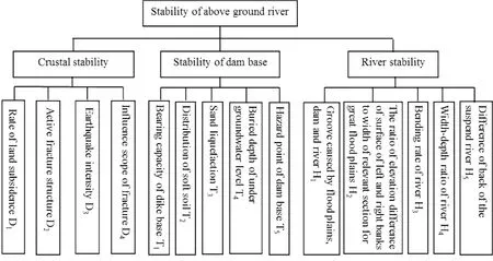
Fig.3 Hiberarchy model on evaluating stability of suspend Yellow river

Table 1 Weights of factors
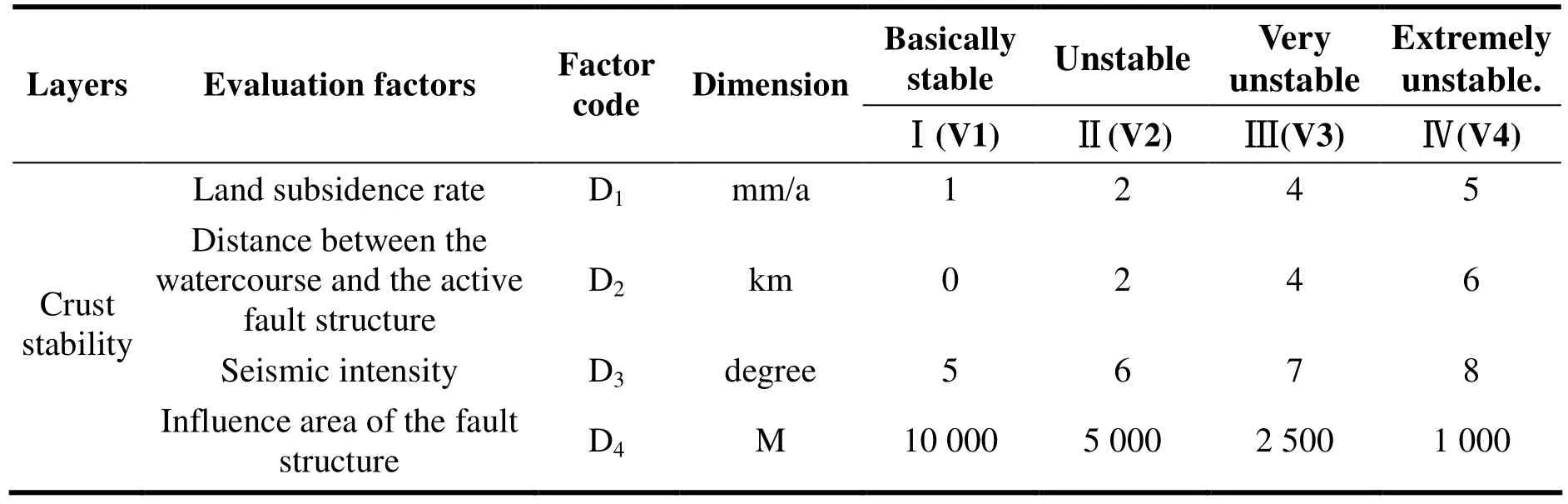
Table 2 Graded evaluation factors for aboveground river stability

(Continued table)

Table 3 Membership functions used in simulating the membership functions of some quantitative indexes

Where, (1): A-weight matrix for factor sets,ai-weight value of the ith evaluation index for the total goal; R- the general evaluation matrix formed by n evaluation factors, uij- the membership degree of the its index relative to the jth grade; B - comprehensive judgment matrix (the result of the comprehensive judgment), bj- comprehensive evaluation index for the jth grade
3.2.2.4 Determining the weights of the factors
We average the weight value given by 12 experts according to the contribution and the importance of the evaluation factors involved in the aboveground river stability evaluation, the table is made as follows.
3.3.2.5 Evaluation criterion
According to the regional geological conditions,there are roughly four stability evaluation protocol of the aboveground river: basically stable, unstable,very unstable, and extremely unstable. The corresponding evaluation sets are: V=(V1(basically stable), V2(unstable), V3(very unstable), V4(extremely unstable)).
3.2.2.6 Determining the membership degree
We simulate the membership functions (C Carlsson and R FullEer, 2002; FENG De-yi et al.1985) of some quantitative indexes using minimum and maximum membership functions as seen in Table 3.
3.3 Stability evaluation and its results for aboveground rivers
3.3.1 Stability evaluation for aboveground rivers
First, select 164 calculation points in the evaluation zone for fuzzy evaluation. Then, judge these points using formula (1) of the comprehensive evaluation model under the evaluation methods and criteria. Finally, determine the evaluation result based on the principle of MDM(maximum degree of membership).
Now take an evaluation point, Linpuji Village Juancheng County located in Dongbatou-Taochengpu section of Lower Yellow River, for example, to illustrate the concrete evaluation process.
Based on the regional environment factors which will affect the stability of the aboveground river, the Weighting matrix A in this area for the crust stability, dike stability, watercourse stability and the comprehensive stability of the aboveground river stability is obtained with the above methods as followed:
AD=(0.15 0.35 0.30 0.20 )T, AT= (0.10 0.20 0.35 0.15 0.20)T, AH= (0.20 0.25 0.15 0.10 0.30)T,AZ=(0.35 0.35 0.30 )T
The overall evaluation matrix R formed by the evaluation factors of the crust stability, dike stability, watercourse stability and the comprehensive stability for the aboveground river stability is as follows:

Using evaluation formula (1) B= A·R, we get the evaluation result of the crust stability, dike stability, watercourse stability and the comprehensive stability for the aboveground river as follows:
(1) Evaluation result for crust stability
Based on the principle of MDM (maximum degree of membership) the stability evaluation result of this evaluation point is determined as“extremely unstable”.
(2) Evaluation result for dike stability.
Evaluation matrix for dike stability B= AT·RT= (0.55 0.02 0.215 0.215). Based on the principle of MDM (maximum degree of membership) the stability evaluation result of this evaluation point is determined as “basically stable”.
(3) Evaluation result for watercourse stability.
Evaluation matrix for watercourse stability B=AH·RH = (0 0.285 0.442 0.273). Based on the principle of MDM (maximum degree of membership) the stability evaluation result of this evaluation point is determined as “unstable”.
(4) Evaluation result for the comprehensive stability of the aboveground river
Evaluation matrix for the comprehensive stability of the aboveground river B= AZ·RZ =(0.193 0.093 0.313 0.402). Based on the principle of MDM (maximum degree of membership) the stability evaluation result of this evaluation point is determined as “extremely unstable”.

Table 4 Comprehensive stability zones of aboveground river in lower reaches of Yellow River
3.3.2 The stability evaluation result and its discussion for the aboveground river
According to the above evaluation methods and procedures, all the evaluation points in the area are evaluated one by one, and the evaluation results are shown in Table 4 and Fig. 4.
The evaluation result of the crust stability, dike stability, watercourse stability for the aboveground river.
The evaluation results of the crust stability,dike stability, watercourse stability for the aboveground river are shown in Fig. 4.
Comprehensive evaluation result for the stability of the aboveground river.
The comprehensive evaluation result for the stability of the aboveground river is shown in Fig.4. As can be seen in Fig. 4, the whole watercourse of the lower Yellow River consists of 17 sections of different stability; they are basically stable,unstable, very unstable and extremely unstable sections respectively. Their locations and the major geological features are as shown in Table 4.
4 Analysis of aboveground river instability risk
Comprehensive evaluation results show that the aboveground river stability in the lower reaches of the Yellow River is divided into four levels, i e.extremely unstable, very unstable, unstable and basically stable, and a total of 11 sections. Except Pingyin County-Zhaoguan Town in Qihe County,Fuzudian in Qihe County-Huashan Town in Jinan are basically stable, the rest are all in the extremely unstable, very unstable or unstable state, facing the possibility of dike breach instability. Then, what positions in the aboveground river are most prone to burst in the next 50 years, and how much is the risk?
4.1 Disaster prediction of instability or levee breach danger point
Through comprehensively considering such circumstances as future earthquakes, river position difference, river regime & type, history dike breach, foundation soil liquefaction, seepage deformation, etc., in the next few decades, there may be 17 most unstable hazardous locations in the above 11 sections if the aboveground river is not fully controlled, namely Wuzhi, Fengqiu,Changyuan, Wangchenggu, Zhongmou, Kaifeng,Dongbatou, Dongming, Licun Town-Dongkou,Gezhuang-Jiucheng Town, Liji, Yuncheng-Daimiao, Dong'e, Zhaoguan Twon, Zhu'e-Daqiao Town, Jiyang, and Wangzhuang-Beiling, these locations are likely to have dike breach occurred.For locations of these geological risk points,possible instability or dike breach controlling factors, etc. please refer to Fig. 4.
4.2 Disasters analysis after the instability of several typical risk points
4.2.1 Social and economic harm to the lower reaches
According to the data obtained in the survey and in combination with the research findings of Ye Qingchao et al. (YE Qing-chao et al. 1997; LU Zhong-chen et al. 1987; LIU Shan-jian et al. 1985),we made an estimate about the regional area that is possibly submerged after the dike breach of several risk sections like Wuzhi, Zhongmou, Kaifeng,Fengqiu, Dongming, Changyuan, Dong'e, etc.respectively 33 000 km2, 28 000 km2, 28 000 km2,18 500 km2, 13 300 km2, 8 000-10 500 km2, and 10 500 km2. These areas that are possibly submerged after the dike breach are all small urban areas except Kaifeng. According to related data of 2003 China City Statistical Yearbook (Editorial Board of China Research Society of Urban Development, 2003), we reckoned the population density and level of economic development of these areas in Shandong Province and Henan Province in 2006, and also obtained the submergence involved population and area and resulting economic losses of the 7 risk sections like Wuzhi, Zhongmou, Kaifeng, Fengqiu, Dongming,Changyuan, Dong'e, etc. after the 2006 dike breach, as shown in Table 3C. The table reveals that the dike breach of any risk section will cause enormous losses to the lower reaches.
4.2.2 Harm to Transportation, Communications, Major Projects, etc.
The dike breach in the lower reaches of the Yellow River will spread across Beijing-Guangzhou Line, Tianjin-Pukou Line,Lianyungang-Lanzhou Line, Xinxiang-Heze Line and other important trunk railways as well as crisscrossed road networks, and flooding floods will also destroy or submerge these transport routes to cause traffic disruptions. In the spreading range of the dike breach, there is a project to bring the Yellow River to relieve Qingdao, Beijing and Tianjin and the ongoing East Line Works of the South-to-North Water Diversion Project, as well as the Yellow River Irrigation Project, Zhongyuan Oilfield, Shengli Oilfield, a variety of communications facilities, etc. that have been developed for decades. The dike breach flood in the aboveground river will cause varying degrees of damage to such projects, communication facilities, oilfields, etc. or make the production halt, thereby bringing a huge impact.
4.2.3 Impact on coastal ecological environment
The plain in the lower reaches of the Yellow River is caused by continuous flooding of the Yellow River; as human beings establish dikes to restrain the Yellow River and economic activities on both banks, the natural environment has been significantly changed, and floods after dike breach will have a huge impact on both banks, mainly reflected in: ① The floods capture the flooding of other rivers and river watercourses, result in severe siltation, make morphology of the river captured change, even disrupt the entire water system,destruct piers along the river, absorption and drainage facilities and river renovation works, etc.Floods into lakes may cause siltation, reduce the storage capacity of lakes against river flooding,and even cause lake disappearance if very severe.② F loods c an also cause changes in the biological populations of receiving rivers and lakes, affect diversity of the populations, reduce environmental capacity of water bodies and intensify water pollution. ③ Floods will also carry and diffuse such harmful substances as garbage, industrial waste, urban sewage, etc. in the flooded area,thereby causing environmental pollution and even leading to epidemics and so on.
4.3 Recommendation about prevention of aboveground river instability
Once aboveground rivers in the lower reaches of the Yellow River become instable, it will cause very serious social, economic and ecological problems, so relevant departments should pay more attention, continue to use middle and upper reaches of water conservancy projects for water and sediment regulation in the lower reaches, and also increase investment, carry out environmental geological surveys and geological environment dynamic monitoring in the lower reaches of the Yellow River, identify the impact of water and sediment regulation on the geological environment on both sides of the river watercourses in the lower reaches and on stability of the aboveground rivers,further identify regional active fractures affecting stability, engineering geological conditions of dikes and a variety of potential risks, intensify the control efforts against rock erosion in the middle reaches, and thus provide more detailed and more reliable scientific basis for management and development of the Yellow River.
Acknowledgements
National science & technology support plan,geological environmental risk assessment during urban development and Research and demonstration of key prevention and control technologies(2012BAJ11B00).
杂志排行

地下水科学与工程(英文版)的其它文章
- Emergency water supply capacity analysis of major cities in Hebei
- Study of water resources for crop utilization in China from the perspective of Virtual Water
- Sustainable utilization measures of groundwater resources in Beijing
- Analysis of bromate and bromide in drinking water by ion chromatography-inductively coupled plasma mass spectrometry
- Characteristics-based classification research on typical petroleum contaminants of groundwater
- Study of moisture migration in clay soils considering rate of freezing