Quantitative lithofacies palaeogeography
2014-09-27ZengZhaoFengXiuJuanZhengZhiDongBaoZhenKuiJinShengHeWuYouBinHeYongMinPengYuQingYangJiaQiangZhangYongShengZhang
Zeng‑Zhao Feng , Xiu‑Juan Zheng Zhi‑Dong Bao Zhen‑Kui Jin Sheng‑He WuYou‑Bin He, Yong‑Min Peng, Yu‑Qing Yang, Jia‑Qiang Zhang, Yong‑Sheng Zhang
1.China University of Petroleum (Beijing), Beijing 100083, China
2.School of Geosciences, Yangtze University, Jingzhou 434023, China
3.Research Institute of Exploration and Development, SINOPEC, Beijing 100083, China
4.China Oil fi eld Services Limited of CNOOC Ltd., Beijing 101149, China
5.Oil and Gas Research Center, China Geological Survey, Beijing 100029, China
6.Chinese Academy of Geological Sciences, Beijing 100037, China
1 Introduction*
According to the traditional definition, palaeogeography is a science that studies physical geographical characteristics and their evolution in geological history periods(Feng, 1999a, 1999b).
However, in December 2002, during the 197th Symposium of Xiangshan Science Conference supported by the Chinese Academy of Sciences, as the chairman of this symposium, the first author significantly modified the definition of palaeogeography,i.e., palaeogeography is a science that studies the characteristics and their evolution of physical geography in the geologi-cal history periods and in the human history periods(Feng, 2003).The major modification is that the definition includes physical geographical characteristics and their evolution in the human history periods.Both geological history periods and human history periods are “palaeo”.Both physical geographical characteristics and their evolution in geological history and human history periods belong to the research subjects of palaeogeography.The characteristics and distributions of each physical geographic unit on the surface of the present Earth, such as the characteristics and distributions of lands and seas and their sub-units, are the evolutional results of them during the geological history periods and human history periods.This is the historical relationship between the “palaeo” geography and the “present” geography (Feng, 2003, 2009; Feng and Bao, 2012;Fenget al., 2012).
Quantitative lithofacies palaeogeography is developed on the foundation of traditional palaeogeography.The most important monographs are the following: Grabau,1924-1928; Huang, 1945; Hsieh, 1948; Liu, 1955; Wang,1956, 1985; Mineralogy and Petrology Section of Beijing Petroleum Institute, 1961; Luet al., 1965; Lu, 1979; Mineralogy and Petrology Section of East China Petroleum Institute, 1982; Guanet al., 1984; Liu, 1986; Yin, 1988;Wanget al., 1990; Liuet al., 1993; Liu and Xu, 1994;Zhou and Lin, 1995; Zenget al., 1996; Yinet al., 1999;Maet al., 2009; Zheng and Hu, 2010.
The core of quantitative palaeogeography is quantitative palaeogeographic map.Quantity means that on the palaeogeographic map, the division and identification of each palaeogeographic unit are supported by the quantitative data and quantitative fundamental maps.
Our lithofacies palaeogeographic maps are quantitative or mainly quantitative.A great number of quantitative lithofacies palaeogeographic maps have been published one after another, and the articles and monographs of quantitative lithofacies palaeogeography have been published successively.Thus, quantitative lithofacies palaeogeography was formed and established gradually.
In quantitative lithofacies palaeogeography, the key measure is the single factor analysis and multifactor comprehensive mapping method — the methodology of quantitative lithofacies palaeogeography.
The following is a brief discussion of this methodology and the quantitative lithofacies palaeogeographic maps made by this methodology.
2 Single factor analysis and multifactor comprehensive mapping method —methodology of quantitative lithofacies palaeogeography
2.1 Introduction
The proverb says “squares and circles can not be drawn without compasses and rulers”.
Without the new quantitative methodology that is compatible with the new theory of quantitative lithofacies palaeogeography, it is diff i cult to make the new quantitative lithofacies palaeogeographic maps and the lithofacies palaeogeography will not evolve into a new quantitative stage.Thus, the new quantitative methodology for lithofacies palaeogeography,i.e., the single factor analysis and multifactor comprehensive mapping method is in urgent need.
In the early days, the senior author used to call this methodology “single factor mapping methodology” (Feng,1977, 1979; Fenget al., 1983; Feng, 1987).Later on, this method was called “single factor analysis and comprehensive mapping method” (Feng, 1989, 1992, 1993, 1994).Recently, this methodology was termed “Single factor analysis and multifactor comprehensive mapping method”(Feng, 2004).Although these names are slightly different, they are virtually expressing the same idea.The latest name, “single factor analysis and multifactor comprehensive mapping method”, seems more closely matched to reality and is more adequate.
Single factors are those that can independently ref l ect some characteristics of a sedimentary environment of a certain stratigraphical unit in a certain area.The thickness,rock types, textural components, mineral composition,chemical composition, fossils and their assemblages, and colours of the stratigraphical unit, can all independently ref l ect certain characteristics of the sedimentary environment of the stratigraphical unit in this area, such as the nature of the sedimentary area, the depth of water, the dynamic energy of water,etc., and can to be used as single factors.
The single factor analysis and multifactor comprehensive mapping method includes three steps.First, an in-depth petrological study of each section, especially a fundamental section, should be undertaken in order to obtain various firsthand qualitative and quantitative data,especially quantitative data, and to understand the characteristics of the sedimentary environment of each bed and each stratigraphical unit of each section.Second, from the quantitative data of each section, according to each mapping stratigraphic unit of the research project, select those that can independently ref l ect the sedimentary environment.These are single factors.Then, calculate the percentage of these single factors of each mapping stratigraphic unit of each section in the study area, and compose single factor maps, mainly isoline maps.These single factor maps can quantitatively ref l ect the sedimentary environment of each mapping stratigraphic unit of the study area from different aspects.This is the single factor analysis.Third, superpose these single factor maps and integrate them with other qualitative and quantitative data of the mapping stratigraphic unit in the study area, with the dross discarded and essential selected, with the false eliminated and the true retained, and as a result, the quantitative lithofacies palaeogeographic map of the mapping stratigraphic unit of the study area can be composed.This is the multifactor comprehensive mapping.
The core of this methodology is quantitative.Based on the quantitative data and single factors maps in the study area, through comprehensive analysis and judgement,the quantitative lithofacies palaeogeographic map can be composed.In this lithofacies palaeogeographic map, the division and identif i cation of each palaeogeographic unit are based on quantitative data and quantitative single factor maps.Therefore, this lithofacies palaeogeographic map is no longer a qualitative map or sketch map, but it is a quantitative map instead.Then, the lithofacies palaeogeographic map and the lithofacies palaeogeography are developed forward into the quantitative stage.This is an important development in palaeogeography.
The essence of this methodology is to analyze and recognize a thing from different aspects that can ref l ect the essence of the thing, then, through comprehensive analysis and judgment, and finally to recognize the whole thing.This is consistent with the human’s process of cognition.
In 1977, the first author initiated and applied the single factor analysis and multifactor comprehensive mapping method to compose the first quantitative lithofacies palaeogeographic map,i.e.,the lithofacies palaeogeographic map of the Yeli Formation of Lower Ordovician of Beijing-Tianjing-Hebei-Shandong(Feng, 1977, 1979).Since then, more than thirty years have passed.During these years, the authors continually applied this methodology to carry out the scientif i c researches and to compose the lithofacies palaeogeographic maps of the Cambrian,Ordovician, Carboniferous, Permian, and Triassic of North China, Ordos, South China, Northwest China, and Tarim(Fenget al., 1988, 1990, 1991a, 1991b, 1994a, 1994b,1997a, 1997b, 1998a, 1998b, 2000, 2001, 2005).These researches not only achieved outstanding results, but also further developed and enhanced this methodology.Later on, the authors also applied this methodology to compose the lithofacies palaeogeographic maps of the Cambrian and Ordovician of the whole of China (Fenget al., 2004).The practice has proved that this methodology is effective and plays a key role in composing quantitative lithofacies palaeogeographic maps.
2.2 Description of single factors
During the last thirty years, more than twenty single factors were used by the authors.The following contents are the brief descriptions of the most important single factors.
2.2.1Thickness
The thickness of a stratigraphic unit of a section in the study area was mainly controlled by the subsiding magnitude of the area during the geological period; additionally,it was related with the sediments supply as well.
According to the thickness (m)data of all sections in the study area, the isoline map of thickness (m)of the stratigraphic unit of the area can be composed.
The isoline map of thickness mainly ref l ects the distribution of the stratigraphic unit of the study area and the palaeotectonic framework of the geological period, mainly relative uplift and depression.In the area that terrestrial sediments (especially the coarse-grained terrestrial sediments)are developed, the thickness also ref l ects the supply condition of terrestrial materials.In the area that gravity fl ow sediments are developed, the thickness also relates with this particular transporting medium.
The thickness of a stratigraphic unit does not have the inevitable relationship with the water depth of the sedimentary area.For example, in an area, a stratigraphic unit has a huge thickness which can reach up to some thousands of meters.However, the sedimentary environment of this stratigraphic unit could constantly be in tidal flat facies and hence the water depth was shallow.In this area,because the subsidence rate and sedimention rate were stable and in equilibrium during this geological period, the sedimentary environment would be maintained as a shallow water facies on a tidal flat and the accumulated thickness of sediments was rather large.Another example, in an area, a stratigraphic unit has a small thickness (about a few meters or dozens of meters).However, the water depth of this sedimentary area was very deep.In the starved deep water basin, the sedimentary thickness is often thin.Natu-rally, if the sedimentary thickness of an area is zero, this area was not necessarily as an old land or old island.It is required to identify whether this “zero” is a “sedimentary zero” or an “eroded zero”.If it is a “sedimentary zero”, it means that there were no sediments accumulated in the stratigraphic unit of the area during the geological period.It indicates that this area was an old land or old island.If it is an “eroded zero”, it means that in this area, the stratigraphic unit received sediments during the geological period, but these sediments were eroded off during the subsequent geologic periods.Therefore, the “eroded zero” does not indicate that this area was an old land or old island.
Thus, there is a need for being cautious in interpreting the isoline map of thickness of a stratigraphic unit in an area.
2.2.2Shallow water clastic rocks
The shallow water clastic rocks are conglomerate,sandstone, siltstone and claystone (mudstone and shale),which were deposited in the shallow water environment.The shallow water means that the bottom of the water body in the sedimentary area is above storm wave base.It is mainly the water body on the platform.
The content (%)of shallow water clastic rocks is the percentage of the thickness (m)of shallow water clastic rocks, to the total thickness (m)of the stratigraphic unit of a section in an area.
According to the content (%)data of shallow water clastic rocks of the stratigraphic unit of all sections in the area,the isoline map of content (%)of shallow water clastic rocks of the stratigraphic unit of the area can be composed.
In this isoline map, the area with content of shallow water clastic rocks ≥ 50% can be defined as a shallow water clastic rock platform, or clastic rock platform, or clastic platform.
Sometimes, the shallow water coarse-grained clastic rocks,i.e., conglomerate and coarse-grained sandstone,can be used as a single factor.
The isoline map of the content (%)of shallow water coarse-grained clastic rocks or the distribution map of shallow water coarse-grained clastic rocks can be used to determine the marginal facies of the old land.In addition,the composition, textures and structures of shallow water coarse-grained clastic rocks are also useful to determine the characteristics of the old land, such as the rock types,topographic features,etc.
2.2.3Shallow water carbonate rocks
The shallow water carbonate rocks include various limestone, penecontemporaneous dolostone and reef limestone that were deposited on the shallow water platform.
The content (%)of shallow water carbonate rocks is the percentage of thickness (m)of shallow water carbonate rocks, to the total thickness (m)of the stratigraphic unit of a section in an area.
According to the content (%)data of shallow water carbonate rocks of the stratigraphic unit of all sections in the area, the isoline map of content (%)of shallow water carbonate rocks of the stratigraphic unit of the area can be composed.
In this isoline map, the area with content ≥ 50% of shallow water carbonate rocks can be defined as a shallow water carbonate rock platform, or carbonate platform.
The shallow water carbonate rock platform and the shallow water clastic rock platform are two important palaeogeographic units in shallow water platforms.Usually,these two palaeogeographic units are in inverse relationship.
2.2.4Grains with sparry calcite cement
The content (%)of grains with sparry calcite cement(calculated in thickness (m))is the percentage of thickness(m)of grains in sparry grain limestones of the stratigraphic unit of a section in an area, to the total thickness (m)of the stratigraphic unit of the section in the area.
The statistical method for calculating the content (%)of grains with sparry calcite cement (calculated in thickness(m))is as follows:
Example 1, in an area, in the stratigraphic unit of a section, there is a bed of sparry grain limestone.The thickness of the bed is 2 m, and the content (%)of the grains with sparry calcite cement of the bed is 60%.Then the grains with sparry calcite cement of the bed are 2×0.6=1.2 (m).
Example 2, in the same area, in the same stratigraphic unit of the same section, there is another bed of sparry grain limestone.The thickness of the bed is 3 m, and the content of grains with sparry calcite cement of the bed is 70%.Then the grains with sparry calcite cement of the bed are 3×0.7=2.1 (m).
The total thickness (m)of grains with sparry carbonate cement of all beds of sparry grain limestone in the stratigraphic unit of the section in the area, to the total thickness(m)of the stratigraphic unit of the section, is the content(%)of the grains with sparry calcite cement of the stratigraphic unit of the section in the area.
According to the content (%)data of grains with sparry calcite cement of the stratigraphic unit of all sections in the area, the isoline map of content (%)of grains with sparry calcite cement of the stratigraphic unit of the area can be composed.
第一,以提高学生的听说实践能力为总体目标,培养用所掌握的综合语言知识和技能做事的能力;第二,遵循“输出驱动-输入促成”假设,引导和激活学生在进入大学之前已输入的语言知识和技能,激发学生在真实语境下应用语言知识和语言技能的愿望;第三,根据教学目标,选定合适的教学内容,对实验组的教学内容进行二次改编,同一级别采用相同的教学材料。然后,依次展开教学组织、教学评估、教学实践展示和欣赏。
The content (%)of grains with sparry calcite cement is an important indicator for the dynamic energy of water in a sedimentary area.The area with these grains content ≥30% can be defined as a bank.The area with these grains content 29%-20% can be defined as a penebank.The area with these grains content 19%-10% can be defined as an embryonic bank.The bank is an underwater uplift or underwater highland, and its top surface is above the normal wave base.Here, the water energy is high, and the limemud between grains is winnowed away.Thus, the sparry calcite cement can f i ll in the intergrain space subsequently, and the sparry grain limestone can be formed.The penebank is also an underwater uplift or underwater highland, and its top surface is above or near normal wave base.The water energy of penebank is also high but lower than that of a bank.The embryonic bank is an embryonic form of a bank, and its water energy is lower than that of a bank and penebank,but higher than that of its surrounding environment.
The grains with sparry calcite cement are mainly sandsized intraclasts, ooids and various eroded biograins.Thus,the bank (penebank, embryonic bank)can correspondingly be divided into sand-sized intraclastic bank (penebank, embryonic bank), oolitic bank (penebank, embryonic bank),and biograin bank (penebank, embryonic bank), such as echinoderm grain bank (penebank, embryonic bank), algal grain bank (penebank, embryonic bank),etc.If among these grains, there are many grain types and their relative contents are approximately the same, then the bank (penebank, embryonic bank)can be generally called grain bank(penebank, embryonic bank).
Sometimes, another single factor,i.e., the sparry grain limestones, may be used instead of the grains with sparry calcite cement.According to the content (%)data of sparry grain limestones of all sections of the stratigraphic unit of the area, the isoline map of the content (%)of sparry grain limestones of the stratigraphic unit of the area can be composed.In this isoline map, the area with content of sparry grain limestones ≥ 50% can be defined as a bank, the area with content of sparry grain limestones 49%-30% can be defined as a penebank, and the area with content of sparry grain limestones 29%-10% can be defined as an embryonic bank.
To compose the isoline map of content (%)of the sparry grain limestones may be simpler than that of the isoline map of grains with sparry calcite cement.However, the precision of the former for ref l ecting the water energy of the sedimentary area may be lower than that of the latter.
2.2.5Grains with limemud
The grains with limemud are those grains in shallow water carbonate rocks whose intergrain space is f i lled with limemud.These grains are mainly sand-sized intraclasts,ooids and eroded biograins.In fact, these grains are those grains in various limemud grain limestones.
The content (%)of grains with limemud (calculated in thickness (m))is the percentage of thickness (m)of grains in limemud grain limestones of the stratigraphic unit of a section in an area, to the total thickness (m)of the stratigraphic unit of the section in the area.
The statistical method for calculating the content (%)of grains with limemud (calculated in thickness (m))is the same method used to calculate the content (%)of grains with sparry calcite cement.
According to the content (%)data of grains with limemud of the stratigraphic unit of all sections in the area, the isoline map of content (%)of grains with limemud of the stratigraphic unit of the area can be composed.
Regarding the signif i cance of the sedimentary environments of these grains with limemud, there is a great need to make a concrete analysis.
The grains with limemud are formed and deposited in two situations.First, in an area, the grains are formed in the water with high energy.However, the high energy water is changed to lower energy water subsequently,and these grains are deposited together with limemud in the lower energy water.Second, in an area, the grains are formed in water with high energy.However, the grains are transported to another area with lower energy water subsequently, and these grains are deposited together with limemud in the new area with lower water energy.In the two situations, the grains with limemud and the corresponding limemud grain limestone both can be formed.
In this isoline map of content (%)of grains with limemud, the area with these grains content ≥ 30% can be defined as a bank.The area with these grains content 29%-20%, can be de fined as a penebank.The area with these grains content 19%-10% can be de fined as an embryonic bank.
The bank, penebank and embryonic bank with limemud can be called limemud bank.The bank, penebank and embryonic bank with sparry calcite cement can be called sparry bank.The signif i cance of the two banks is different.
The grains in sparry bank are formed and deposited in water with high energy, and they can ref l ect their sedimentary water with high energy.However, the grains in limemud banks are formed in water with high energy but deposited in water with lower energy, and they can not ref l ect their sedimentary water with high energy.Therefore, it is important to distinguish the two types of bank.
In the previous data of sections measured by other researchers, it is very hard to differentiate the grains with sparry calcite cement or with limemud.We only can obtain the content (%)of grains in general.In this situation, we only can define bank, penebank and embryonic bank in general terms.
About the biograins that are not transported and eroded,they were formed, deceased, disintegrated, accumulated and were buried in the same water body with low energy,therefore coexisted with limemud.The accumulation of the marine biograins in a stratigraphic unit of an area does not ref l ect the high energy of the water body in which these grains experienced.It can only ref l ect that in a certain geological period, this area was favorable for these organisms to live, to breed, and to be preserved.
The area with these biograins content ≥ 50% can be defined as a biocrowd.The area with these biograins content 49%-30% can be defined as a penebiocrowd.The area with these biograins content 29%-10% can be defined as an embryonic biocrowd.
The signif i cance of a sedimentary environment of these biocrowd, penebiocrowd and embryonic biocrowd is different from bank, penebank and embryonic bank of biograins with limemud (see above).
These biocrowd, penebiocrowd and embryonic biocrowd do not form a bioframework, and therefore they are different from reefs (see 2.2.10).
Herein, the authors did not use the terms “biostone”,“biostrome”, “biomount”, or “mount”.
2.2.6Penecontemporaneous dolostone
On the carbonate tidal flat and by the capillary concentration dolomitization and mixed water (dorog)dolomitization, the carbonate sediments not yet consolidated can be transformed into penecontemporaneous dolostone.Usually, this dolostone has mud-sized crystalline or siltsized crystalline texture, lamination or shaly bedding, layered or wavy stromatolites and terrestrial mud.It is characterized always with an earthy yellow colour.Sometimes, it is graduated into muddy dolostone or dolomitic mudstone.The penecontemporaneous dolostone is an ideal indicator for the carbonate tidal fl at.
The content (%)of penecontemporaneous dolostone is the percentage of thickness (m)of penecontemporaneous dolostone of the stratigraphic unit of a section in an area,to the total thickness (m)of the stratigraphic unit of the section in the area.
According to the content (%)data of penecontemporaneous dolostone of the stratigraphic unit of all sections in the area, the isoline map of the content (%)of penecontemporaneous dolostone of the stratigraphic unit of the area can be composed.
In this isoline map, the area with penecontemporaneous dolostone content ≥ 50% can be de fined as a dolostone fl at.The area with penecontemporaneous dolostone content ≥ 50% and mudstone content 49%-30%, can be de fined as a muddy dolostone fl at.The area with penecontemporaneous dolostone content 49%-30% and mudstone content ≥ 50%, can be de fined as a dolomitic mudstone fl at.The area with penecontemporaneous dolostone content 49%-30% and limestone content ≥ 50%, can be defined as a dolomitic limestone fl at.
These dolostone fl at, muddy dolostone fl at, dolomitic mudstone fl at and dolomitic limestone fl at are marginal sediments of the old land with low elevational topography.These marginal sediments are different from those marginal sediments of the old land with high elevational topography, which is characterized by conglomerate and sandstone.The young stage old land with high altitude topography can supply coarse grains to the nearby sea, and therefore the marginal sediments of coarse-grained sedimentary rocks, such as conglomerate and sandstone, can be formed.The old stage old land,i.e., the peneplaned old land, can only supply fine grains to the adjacent sea, and therefore the marginal sediments of siltstone, mudstone,and penecontemporaneous dolostone, can be formed.Thus, in the adjacent sea of old stage old land, the mudstone fl at, dolomitic mudstone fl at, muddy dolostone fl at,and dolostone fl at are developed.
2.2.7Deep water sedimentary rocks
The deep water is speci fi ed as the water body in the basin and on the slope, while the shallow water is speci fi ed as the water body on the platform.
The deep water sedimentary rocks are mainly siliceous rock, limestone, mudstone, shale, and various gravity fl ow sedimentary rocks.These rocks are always with a dark colour, thin layer, deep water fossils, and other deep water characteristics.
The content (%)of deep water sedimentary rocks is the percentage of thickness (m)of deep water sedimentary rocks of the stratigraphic unit of a section in an area, to the total thickness (m)of the stratigraphic unit in the area.
According to the content (%)of deep water sedimentary rocks of the stratigraphic unit of all sections in the area,the isoline map of content (%)of deep water sedimentary rocks of the stratigraphic unit of the area can be composed.
In this isoline map, the area with deep water sedimentary rocks content ≥ 50% can be defined as a deep water sedimentary area, but the area with deep water sedimentary rocks content < 50% can be defined as a shallow water sedimentary area.
According to the shape of the deep water sedimentary area, an area with a roughly circular shape can be defined as a basin, and the area with an elongated shape can be defined as a trough.Usually, the slope is considered to be a deep water area.
Obviously, the deep water sedimentary area may be approximate.If the conditions permitted, the deep water siliceous rock, limestone, mudstone and shale, and f l ysch can be utilized as single factors.In addition, the isoline map of the content (%)of deep water siliceous rock, deep water limestone, deep water mudstone and shale, and deep water fl ysch can be composed.In these isoline maps, according to the content ≥ 50%, the deep water siliceous rock basin(or trough), the deep water limestone basin (or trough), the deep water mudstone and shale basin (or trough), and the deep water f l ysch basin (or trough), can be defined.These palaeogeographic units are not approximate and may be definite.
Now, there appears a question.Whether approximate or definite, which one is better? It depends on concrete circumstances.Actually, they both have their own advantages and functions.In concrete practice, people should select a single factor that suits with the specif i c condition and purpose.
According to the situation of the deep water sedimentary area, it can be divided into two types.One is the deep water area inside the shallow water area, and another is the deep water area outside the shallow water area.Usually, the dimensions of deep water inside the shallow water area are not large and its depth is not too deep.However the dimensions of deep water area outside the shallow water area can be very large and the depth of it can be quite deep.The deep water area outside the shallow water area is called deep sea or ocean, such as the Qinling Ocean between the North China Platform and Yangtze Platform, the Tianshan Ocean between the Junggar Platform and Tarim Platform,etc.In the palaeogeographic map of the present boundary, the dimensions of deep sea or deep ocean outside the shallow water platform are always small and usually distributed as a narrow belt between two platforms.This is the so called “decreased belt of palaeoocean” by Wang (1985).
The deep water areas inside the platform and outside the platform are two types of deep water area, and have different characteristics.However, due to the limitation of research work, sometimes, it is hard to distinguish them.In this case, researchers should conduct the comprehensive analysis and make decision carefully.
2.2.8Gypsum
Gypsum is a mineral or rock of an evaporitic environment, which is mainly formed in the saline lagoon, inland salt lakes, and dolostone flat in the supratidal zone.
The content (%)of gypsum is the percentage of thickness (m)of gypsum of the stratigraphic unit of a section in an area, to the total thickness (m)of the stratigraphic unit of the section in the area.
According to the thickness (%)data of gypsum of the stratigraphic unit of all sections in the area, the isoline map of content (%)of gypsum of the stratigraphic unit of the area can be composed.
In this isoline map, the area with gypsum content ≥50% can be defined as a gypsum lake.The area with gypsum content 49%-30% can be defined as a gypsum-bearing lake.Because gypsum commonly coexists with penecontemporaneous dolostone, the area with gypsum content 49%-30% and penecontemporaneous dolostone content is≥ 50%, can be defined as a gypsum dolostone flat.
Sometimes, in the isoline of gypsum, the area with gypsum content ≥ 30% can be defined as a gypsum lake, the area with gypsum content 29%-10% can be defined as a gypsum-bearing lake, and the area with gypsum content 30%-10% and penecontemporaneous dolostone content≥ 50% can be defined as a gypsum dolostone flat or gypsum-bearing dolostone flat.
Gypsum is not only an excellent cap rock for oil and gas reservoirs, but also is an important mineral deposits.Thus,the isoline map of content (%)of gypsum has an important economic signif i cance.
2.2.9Salt
The salt is also a mineral or rock of an evaporitic environment, which is mainly formed in the high saline lagoons or inland salt lakes.
The content (%)of salt is the percentage of thickness(m)of salt of the stratigraphic unit of a section in an area,to the total thickness (m)of the stratigraphic unit of the section in the area.
According to the thickness (%)data of salt of the stratigraphic unit of all sections in the area, the isoline map of the content (%)of salt of the stratigraphic unit of the area can be composed.
In this isoline map, the area with salt content ≥ 30%can be de fined as a salt lake, and the area with salt content 29%-10% can be de fined as a salt-bearing lake.
Salt is also an excellent cap rock for oil and gas reservoirs.The salt and its coexisting potassium and magnesium salts are important mineral resources.Thus, the isoline map of content (%)of salt is also an important economic map.
Because gypsum and salt are usually coexisting together, sometimes, the area with the gypsum and salt content is ≥ 50% or ≥ 30% can be de fined as a gypsum-salt lake.
2.2.10Other single factors
Beside the above sedimentary single factors, the authors also used some other single factors, such as reef and fossil assemblages.
The reef is an important index in the carbonate platform.It is very useful in researches of sedimentary environment and lithofacies palaeogeography.However, the content of reef (%)of a stratigraphic unit in an area can not be easily composed.Therefore, we always mark the distribution of reefs instead of the isoline map of the content (%)of reef.This non-quantitative distribution map of reefs is very useful.
Some fossil assemblages, such as benthic fossil assemblage, nektonic organism fossils assemblage, planktonic fossil assemblage and plant fossil assemblage, can be used as single factors to determine sedimentary environments.
Trace fossils and their assemblages can also be used as single factors to re fl ect depositional environments, but we have not carried out this research yet.
In addition, chemical elements, mainly minor elements and rare earth elements, can be used as single factors.Many geologists have conducted this research, but we have not yet.
Overall, according to the concrete circumstance of a stratigraphic unit in an area, we can select some single factors that can re fl ect sedimentary environments, and make corresponding single factor maps.On this basis, the quantitative lithofacies palaeogeographic map can be composed.
In the following two sections, we utilize two case studies to explain how to use the single factor analysis and multifactor comprehensive mapping method to compose the quantitative lithofacies palaeogeographic maps, and discuss the palaeogeographic units in the quantitative lithofacies palaeogeographic maps.
3 Composition of quantitative lithofacies palaeogeographic map of the early age of Early Ordovician in South China
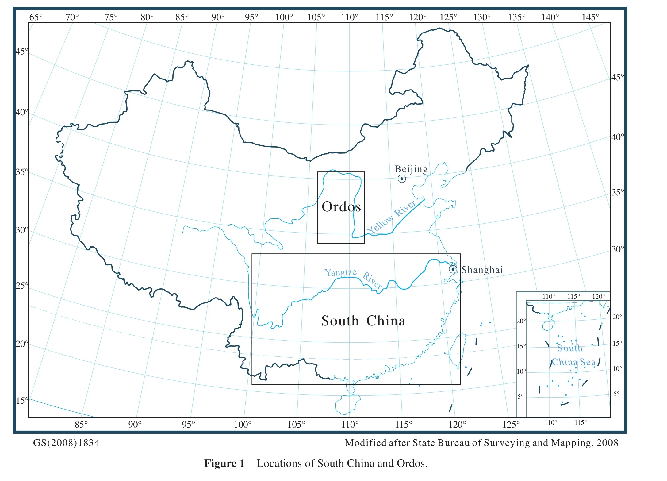
South China in this article refers to the broad area of the south of China (Figure 1).It extends to the Jinshajiang River-Yuanjiang River Fracture in the west, to the Longmenshan Fracture in the northwest, to the Chengkou-Fangxian-Guangji Fracture in the north, to the Tancheng-Lujiang Fracture in the northeast, to the Yellow Sea and East China Sea in the east, to the South China Sea in the south.It covers a part or the whole area of 17 provinces,cities and regions,i.e., Yunnan, Guizhou, Guangxi, Sichuan, Shaanxi, Hubei, Hunan, Jiangxi, Anhui, Jiangsu,Zhejiang, Fujian and Guangdong Provinces, Chongqing and Shanghai Cities, Hongkong and Macao Regions.Its area is about 2,000,000 km2.
The Ordovician is widely distributed in South China.We have utilized the lower part of Lower Ordovician (Xinchang Stage, or Lianghekou Stage, or Tremadocian Stage)as an example to explain how to use the single factor analysis and multifactor comprehensive mapping method to make the quantitative lithofacies palaeogeographic map,and to discuss the quantitative single factor maps, quantitative lithofacies palaeogeographic maps and palaeogeographic units in the palaeogeographic maps.
3.1 Single factor analysis
3.1.1Isoline map of thickness(m)
According to the thickness (m)data (Table 1)of 157 sections (46 first order outcrop sections, 57 second order outcrop sections, 50 third order outcrop sections, 3 first order well sections, and 1 second order well section), the isoline map of thickness (m)of the lower part of Lower Ordovician in South China was composed (Figure 2).
The first order outcrop sections were measured by us and all quantitative and qualitative data from the sections are reliable.The second order outcrop sections were reviewed or partially measured by us and all quantitative data from which are basically reliable.The third order outcrop sections were measured and studied by previous researchers and were collected by us.These sections were mainly measured by the local geologic survey teams with simple lithologic description and with little quantitative data, in which only the thickness data are reliable.The first order well sections were reviewed by us via the original logging data; in addition, we studied drill cores, lithocuttings, and thin sections under the microscope; all these quantitative and qualitative data are reliable.The second order well sections were reviewed by us via the original logging data, the thickness data of which are reliable, but the other data can only be used as references.The third order well sections were not reviewed by us, thus, they only can be used as references.
From Figure 2, it can be seen:
1)The area of zero thickness is located in the western area,i.e., the Hanzhong, Guangyuan, Kangding, Kunming,and Zhenxiong area.The surrounding strata are gradually thinning towards the area and become zero, not suddenly reach zero.This area was an eroded area, which did not receive sediments during the early age of Early Ordovician.It was an area of “sedimentary zero”.It was inherited from the Late Cambrian.
2)In the northwest area,i.e., the Yangtze area, the strata thickness is relatively thin, 100-300 m in general; in one place (section 97), the thickness is > 500 m.
3)In the southeast area, the stratal thickness is quite large.In section 124, the thickness is > 1000 m.There are 9 sections in which the thickness is 500-1000 m, such as sections 80, 81, 109, 113, 112, 106, 129, 130, and 134.
4)In the central area,i.e., the Jiangnan area, the strata thickness is the thinnest, <100 m in general.
5)The thickness pattern, thin in the northwest area,thicker in the southeast area, and thinnest in the central area, was also inherited from the Cambrian.
3.1.2Isoline map of content(%)of deep water shale
According to the content (%)data of deep water shale of 57 sections (12 first order outcrop sections, 23 second order outcrop sections, 22 third order outcrop sections)(Table 2), the isoline map of content (%)of deep water shale of the lower part of Lower Ordovician in South China was composed (Figure 3).
From Figure 3, it can be seen:
1)Many sections with deep water shale content ≥ 50%are distributed in the Jiangnan area.This area is the thinnest area.
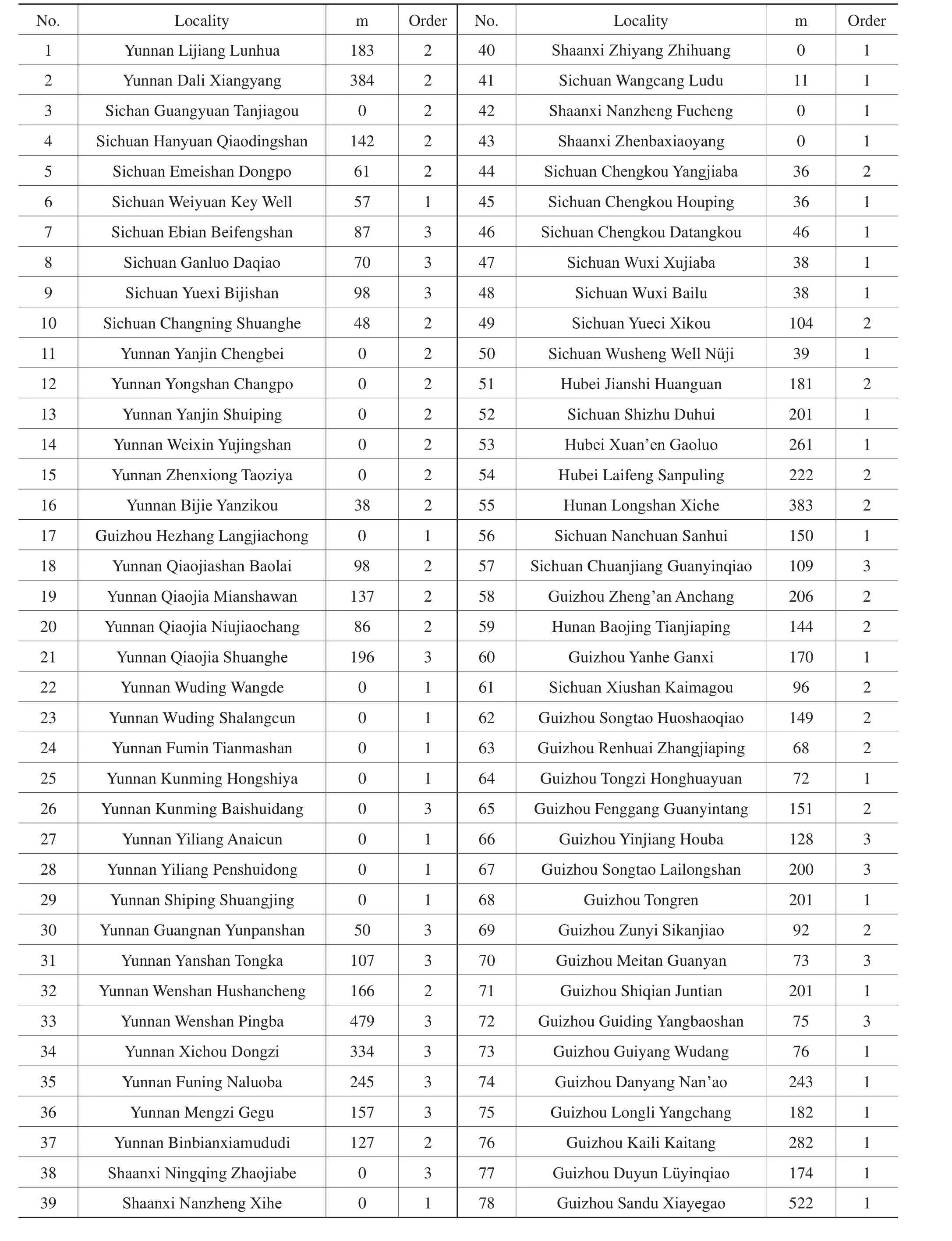
Table 1 Thickness (m)of 157 sections of the lower part of Lower Ordovician in South China
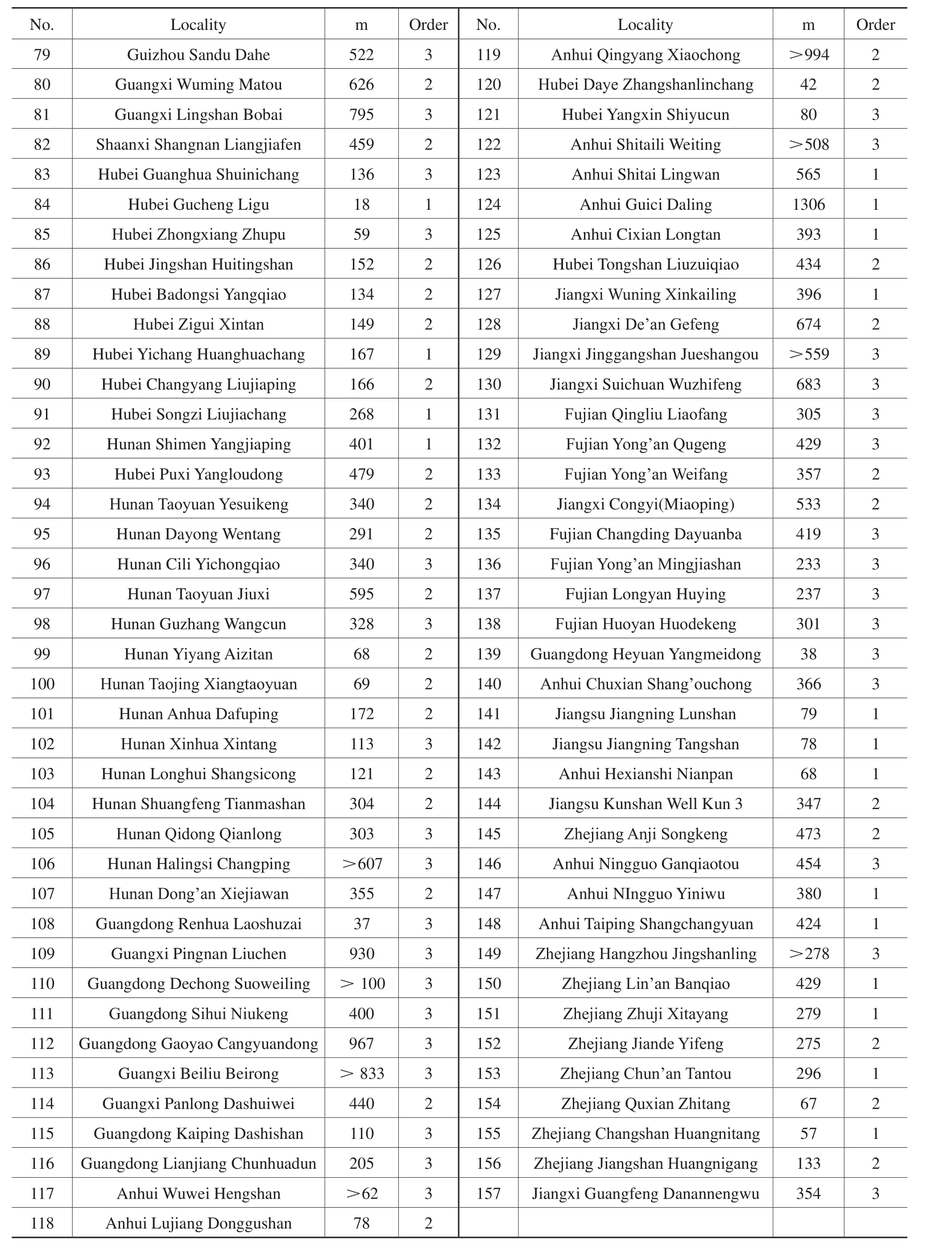
Table 1 (continued)
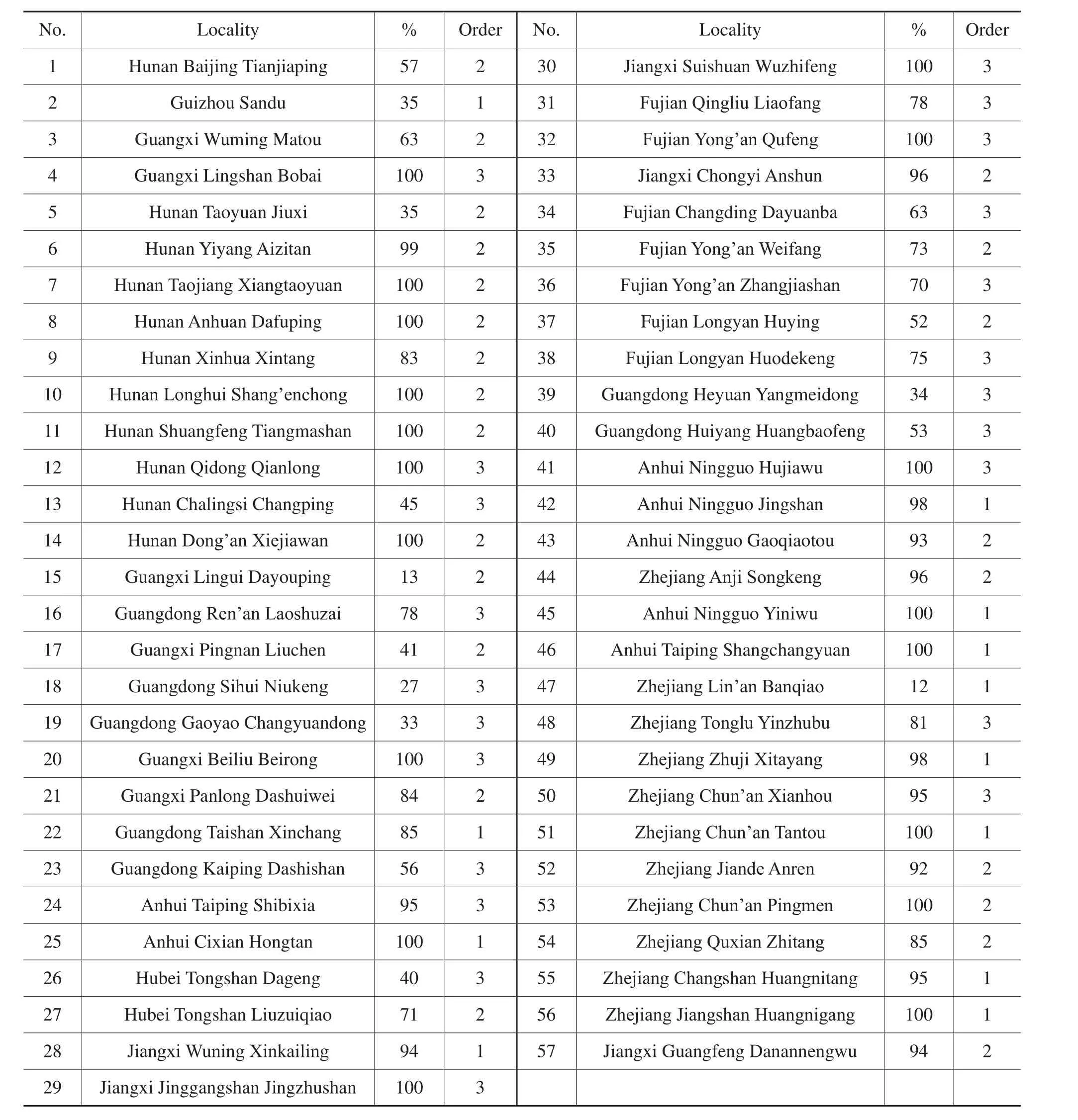
Table 2 Content (%)of 57 sections of deep water shale of the lower part of Lower Ordovician in South China
2)18 sections with deep water shale content ≥ 50% are scattered in the southeast area.
3.1.3Isoline map of content(%)of shallow water carbonate rocks
According to the content (%)data of shallow water carbonate rocks of 80 sections (19 first order outcrop sections,20 second order outcrop sections, 37 third order outcrop sections, 3 first order well sections, and 1 second order well section)(Table 3), the isoline map of content (%)of shallow water carbonate rocks of the lower part of Lower Ordovician in South China was composed (Figure 4).
Form Figure 4, it can be seen:
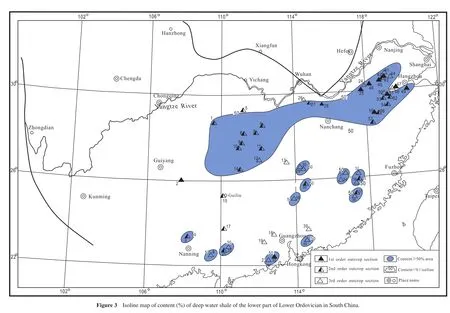
1)The sections with the content of shallow water carbon-ate rocks ≥ 50% are mainly distributed in the Yangtze area.
2)Its northwestern boundary is about the line of Gejiu-Zhenxiong-Yibin-Chengdu-Chengkou-Xianfan-Wuhan-Hefei.Its southeastern boundary is along the line of Funing-Jishou-Yueyang-Hangzhou.
3.1.4Isoline map of content(%)of grains of shallow water carbonate rocks
The statistical method for grains (calculated in thickness (m))is mentioned above (2.2.4).
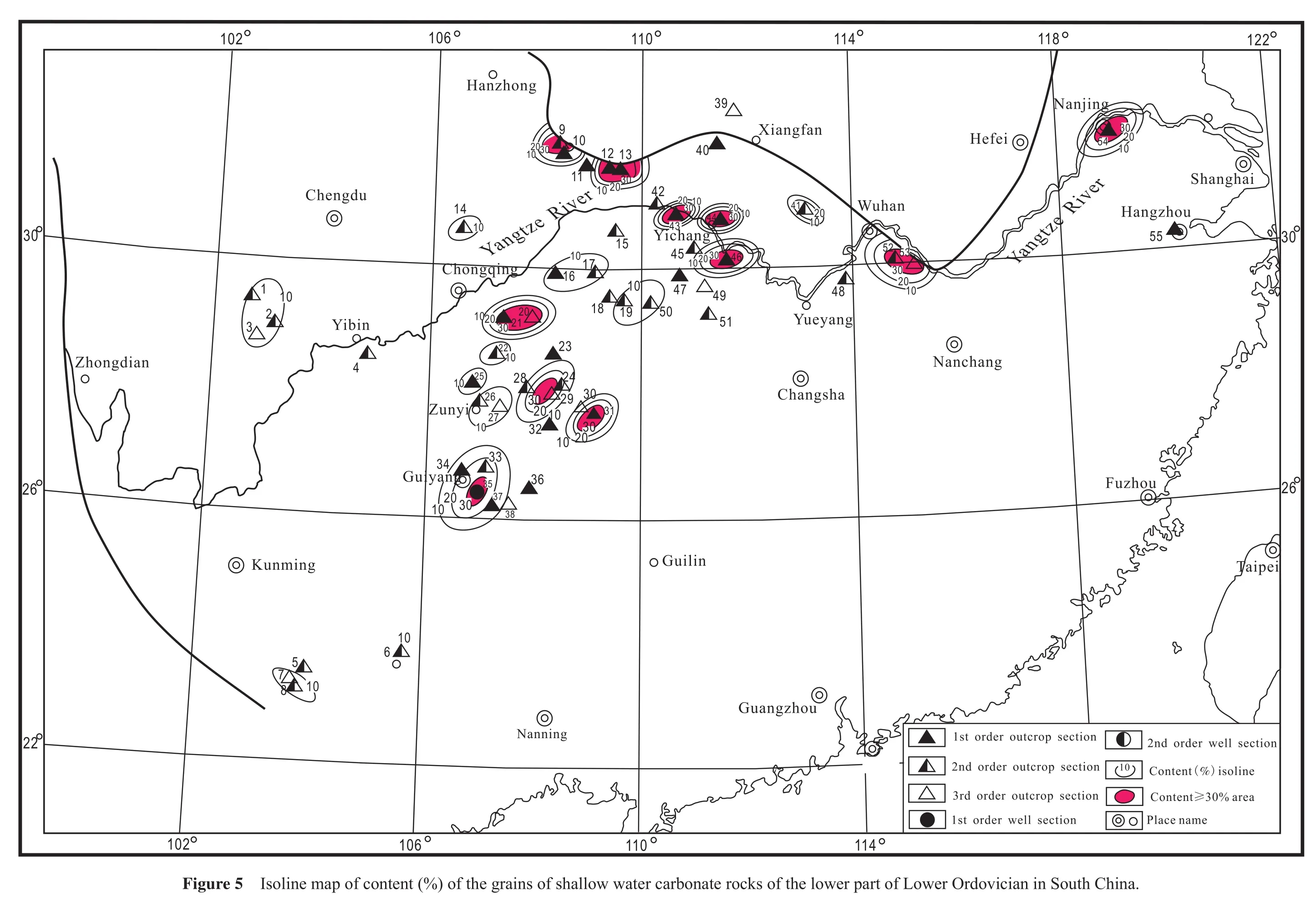
According to the content (%)data of the grains of shallow water carbonate rocks of 55 sections (4 first order outcrop sections, 19 second order outcrop sections, 31 third order outcrop sections and 1 first order well section)(Table 4), the isoline map of content (%)of the grains of shallow water carbonate rocks of the lower part of Lower Ordovician of South China was composed (Figure 5).
From Figure 5, it can be seen:
1)There are 14 sections in which the grains content is≥ 30%.They are sections 9, 12, 13, 20, 21, 29, 31, 35, 43,44, 46, 52, 53 and 54.
2)There are 4 sections in which the grain content is 29%-20%.They are sections 10, 33, 34, and 41.
3)There are 21 sections in which the grains content is 19%-10%.They are sections 1, 2, 3, 6, 7, 8, 14, 16, 17, 19,22, 24, 25, 26, 27, 32, 37, 40, 45, 47 and 50.
4)Overall, in the lower part of the Lower Ordovician in South China, the grains of shallow water carbonate rocks were developed very well.
3.1.5Isoline map of content(%)of penecontemporaneous dolostone
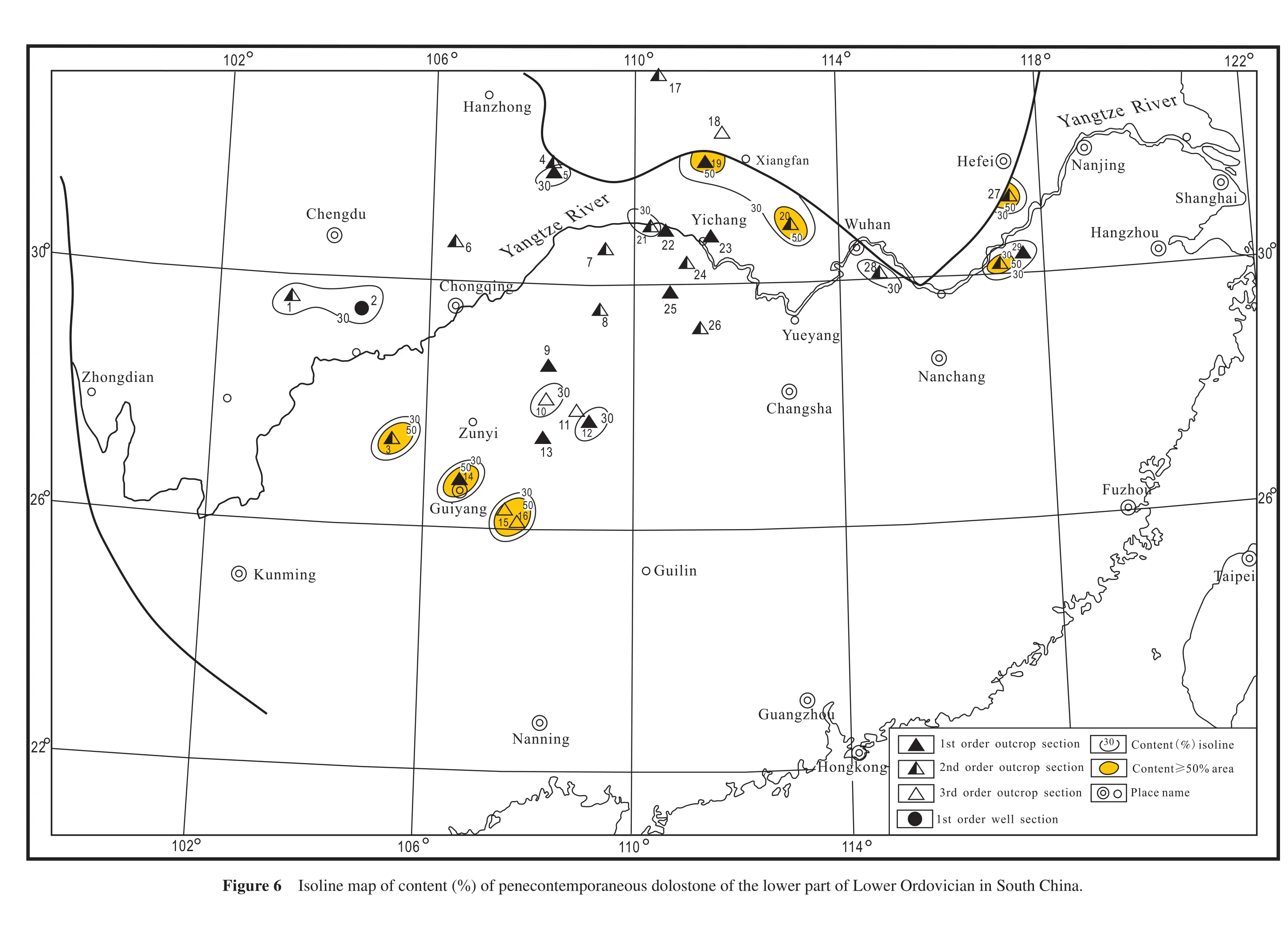
According to the content (%)data of penecontemporaneous dolostone of 30 sections (10 first order outcrop sections, 14 section order outcrop sections, 5 third order outcrop sections, and 1 first order well section)(Table 5),the isoline map of content (%)of penecontemporaneous dolostone of the lower part of Lower Ordovician in South China was composed (Figure 6)
Form Figure 6, it can be seen:
1)There are 9 sections in which the penecontemporaneous dolostone content is ≥ 50%.They are sections 3,14, 15, 16, 17, 19, 20, 27 and 30.
2)There are 8 sections in which the penecontemporaneous dolostone content is 49%-30%.They are sections 1, 2,5, 10, 12, 21, 28 and 29.
3)In general, penecontemporaneous dolostone in the lower part of Lower Ordovician in South China was developed very well.It is worth notice that many penecontemporaneous dolostones occur in the carbonate platform.
3.2 Multifactor comprehensive mapping
Superposing the above single factor maps,i.e., the isoline map of thickness (m)(Figure 2), the isoline map of content (%)of deep water shale (Figure 3), the isoline map of content (%)of shallow water carbonate rocks (Figure 4),the isoline map of content (%)of grains of shallow water carbonate rocks (Figure 5), and the isoline map of content(%)of penecontemporaneous dolostone (Figure 6), and comprehensively analyzing them, especially according to some key isolines, the quantitative lithofacies palaeogeographic map of the early age of Early Ordovician in South China can be composed step by step.
In the isoline map of thickness (m)(Figure 2), the zero thickness area can be defined as an old land.There are two evidence for the old land: ① the surrounding strata gradually thin towards the area and become zero.② the marginal facies of the area are coarse-grained clastic rocks.Therefore, the existence of the old land is credible.This old land can be called Kangdian Land.
Besides Kangdian Land, the rest is sea.
In the sea, according to the isoline map of content (%)of deep water shale (Figure 3), the areas with deep water shale content ≥ 50% can be defined as deep water shale basins.
There are one relatively large shale basin and 11 comparatively small shale basins.The larger one is Jiangnan Shale Basin, or Jiangnan Basin.The 11 small shale basins are located in the Southeast Clastic Rock Platform.
In the sea, besides the deep water basins, the rest is shallow water platform.
In the shallow water platform, according to the isoline map of content (%)of shallow water carbonate rocks (Figure 4), the area with shallow water carbonate rocks ≥ 50%can be defined as a carbonate rock platform,i.e., Yangtze Carbonate Rock Platform.
In the shallow water platform, the content (%)of shallow water carbonate rocks and the content of shallow water clastic rocks have an inverse relationship.Therefore,the area with shallow water carbonate rocks content <50% (i.e., the shallow water clastic rocks content ≥ 50%)can be defined as clastic rock platforms,i.e., Southeast Clastic Rock Platform and Chuanxi-Diandong Clastic Rock Platform.
The Southest Clastic Rock Platform is located in the broad southeast area.
The Chuanxi-Diandong Clastic Rock Platform is located between Kangdian Land and Yangtze Carbonate
Platform.The Chuanxi-Diandong Clastic Rock Platform and Yangtze Carbonate Rock Platform combined together,can be called the Yangtze Platform.
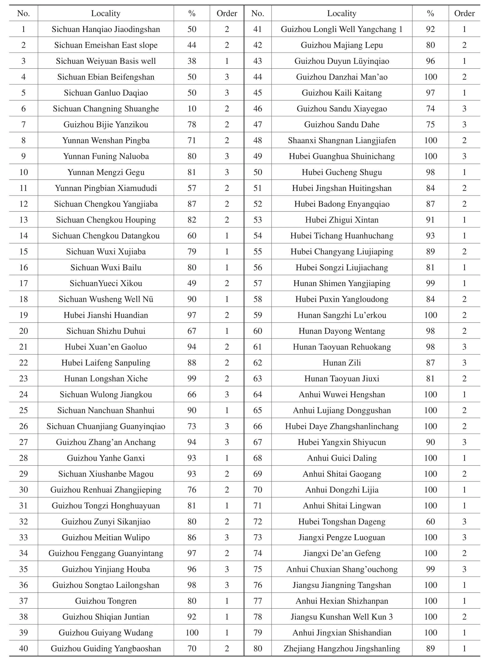
Table 3 Content (%)of 80 sections of shallow water carbonate rocks of the lower part of Lower Ordovician in South China
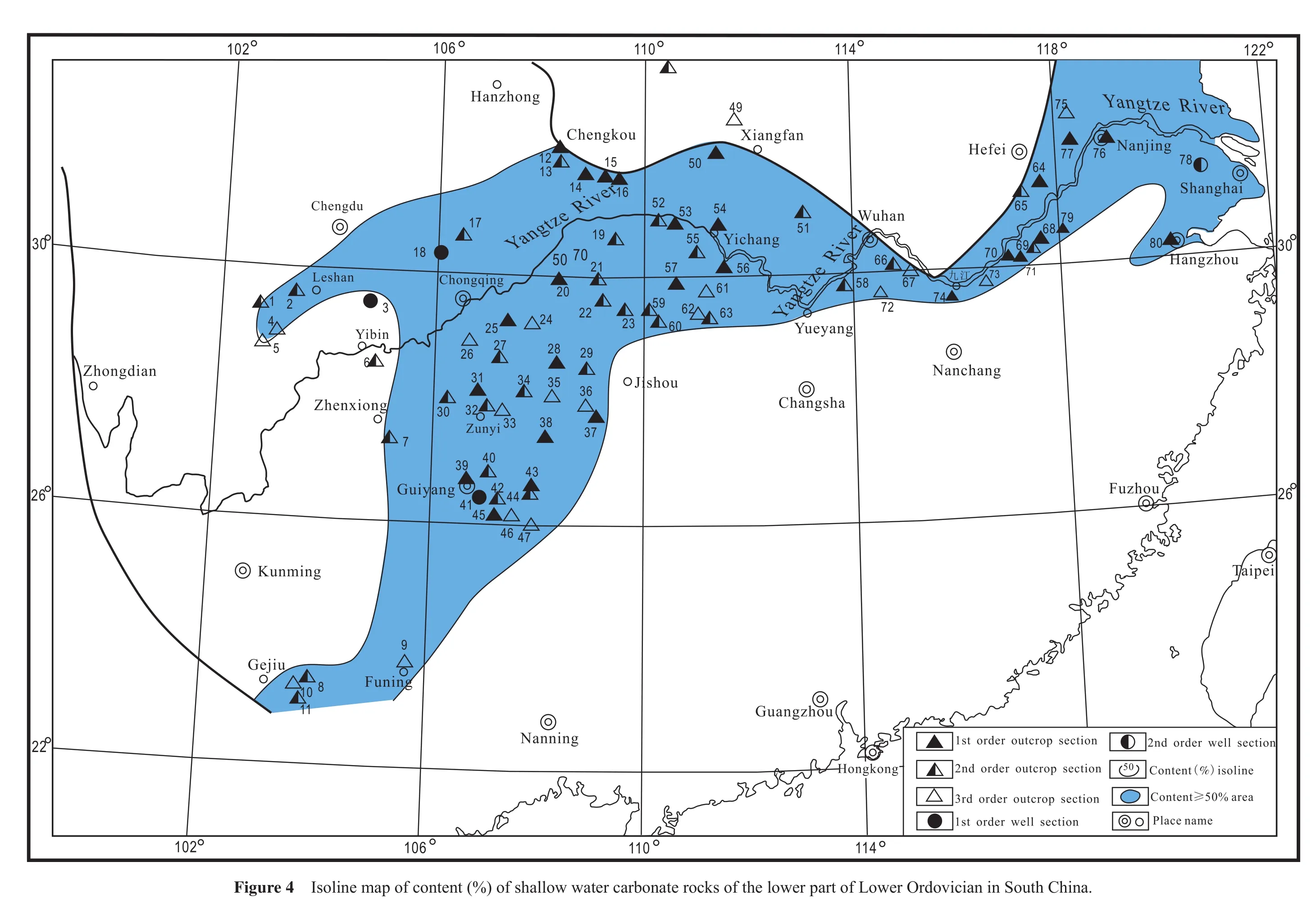
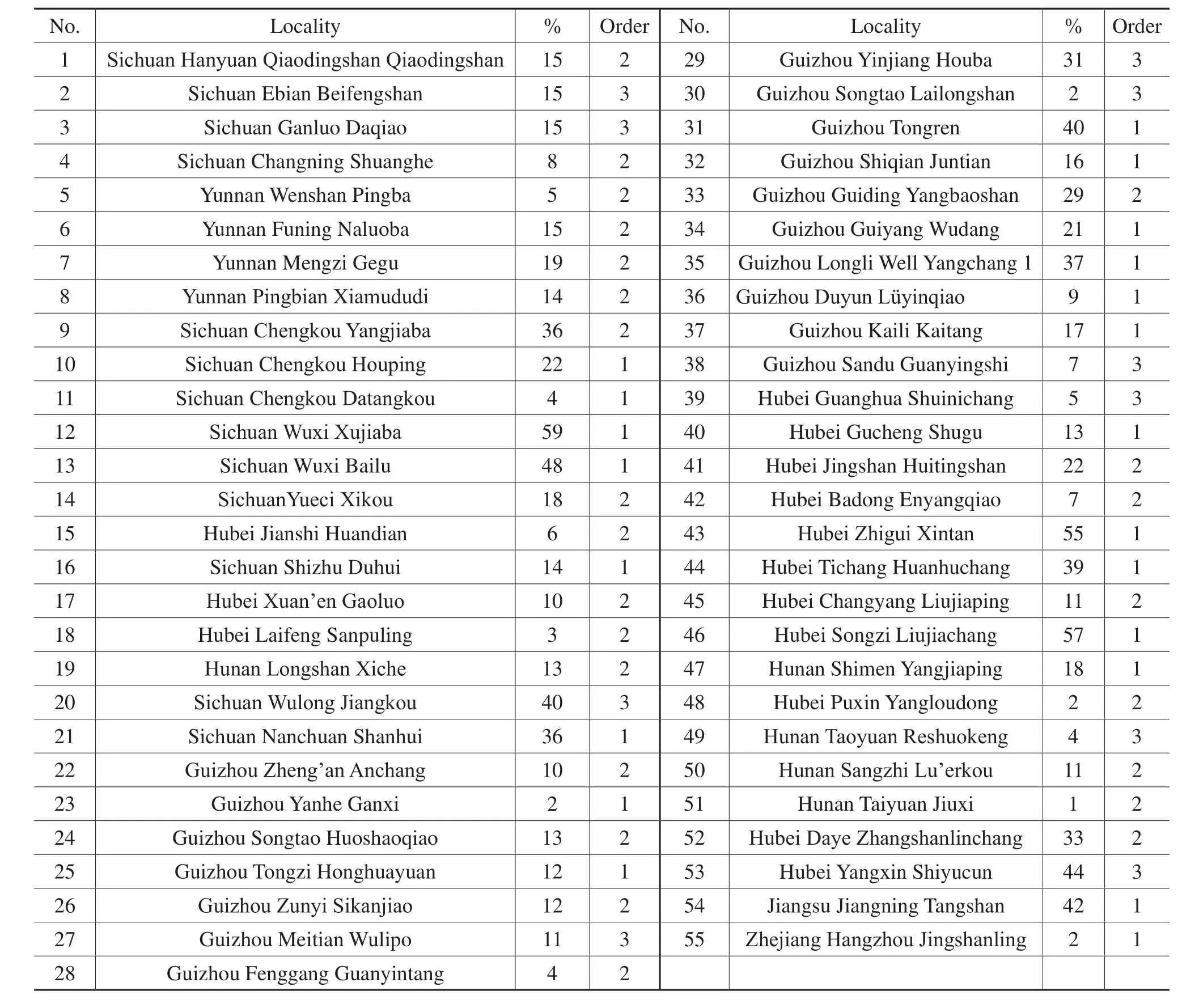
Table 4 Content (%)of 55 sections of grains of shallow water carbonate rocks of the lower part of Lower Ordovician in South China
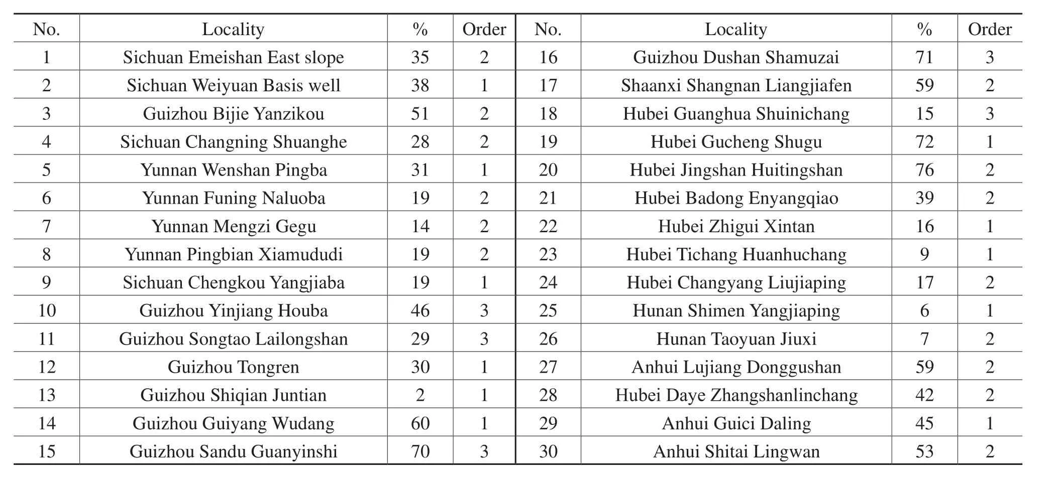
Table 5 Content (%)of 30 sections of penecontemporaneous dolostone of the lower part of Lower Ordovician in South China
The Dianxi Platform is located in the west of Kangdian Land.Because of the limitation of the petrographic data, it can only be called Dianxi Platform in general.
In the Yangtze Carbonate Platform, according to the isoline map of content (%)of grains of carbonate rocks(Figure 5), the areas with content of grains of carbonate rocks ≥ 30% can be de fined as banks.There are 11 banks.
In the Yangtze Carbonate Rock Platform, according to the isoline map of content (%)of penecontemporaneous dolostone (Figure 6), the areas with penecontemporaneous dolostone content ≥ 50% can be de fined as dolostone fl ats.There are 7 dolostone fl ats.
In this way, based on the single factor maps, the quantitative lithofacies palaeogeographic map of the early age of Early Ordovician of South China (Figure 7)was composed step by step.
In the following, we will discuss the palaeogeographic units in this quantitative palaeogeographic map.
3.3 Discussion of palaeogeographic units
In the quantitative lithofacies palaeogeographic map of the early age of Early Ordovician of South China (Figure 7), there were lands, basins, platforms, banks and fl ats.The characteristics of these palaeogeographic units will be discussed below.
3.3.1Kangdian Land and Cathaysia Land
There were two Lands,i.e., Kangdian Land and Cathaysia Land.Kangdian Land was located in the western part of Figure 7.Cathaysia Land should be located in the eastern part of Figure 7, however, it does not appear on this map.
Kangdian Land was located in the area of Hanzhong,Guangyuan, Kangding, Zhenxiong and Kunming.The eastern side of the Land was the Chuanxi-Diandong Clastic Rock Platform.The western side of the Land was the Dianxi Clastic Rock Platform.The areas of the two clastic rock platforms were not large; their main rocks were fine-grained clastic rocks and mudstone.In some areas adjacent to the Land, such as Ganluo and Huili in Sichuan Province, conglomerates and coarse-grained sandstones were present.The Kangdian Land was likely a low relief peneplained land.It mainly suppllied fine-grained materials to adjacent areas.This Land was inherited from the Cambrian.
The Cathaysia Land should be an existed land which should be located on the eastern side of the Southeast Clastic Rock Platform.The clastic materials of the Southeast Clastic Platform were supplied by this Land.Because most of the clastic rocks (mainly fine-grained sandstone,siltstone, mudstone and shale)were lightly metamorphosed, and facies indicators (especially marginal facies indicators)were lacking, the precise location of this Land is hard to determine.According to the current data, we can only propose that Cathaysia Land should be located in the eastern side of the Southeast Clastic Rock Platform,including Taiwan Island, and its precise position is hard to define.
3.3.2Jiangnan Basin and eleven small basins
There were a large basin (Jiangnan Shale Basin)and eleven small shale basins.
The Jiangnan Shale Basin was located in the central part of the study area.Its main rocks were black shale or silty shale, black siliceous shale, and black thin-bedded chert.At the margin of the basin, there were limestone lenses and limestone interbeds, and they gradually transformed into muddy limestone, nodular limestone and limestone.In Shitai and Yixian of Anhui Province, there were limestone slump breccias.These gravity f l ow sediments are an important indicator of slope facies.
Overall, the Jiangnan Shale Basin or Jiangnan Basin was a typical deep water basin.It was inherited from the Cambrian.
The eleven small shale basins were scattered in the Southeast Clastic Rock Platform.They were isolated basins.The shale in these basins was lightly metamorphosed,and have transformed to metamorphic shale or slate.The thickness of them was about a few hundred meters.They were lacking the obvious indicators of deep water.Thus,the deep water facies of these basins were provisionally determined.
Some geologists connected these small basins together and interpreted the whole Southeast Clastic Rock Platform as a deep sea basin or deep sea trough (Wang, 1985; Liu and Xu, 1994).It was a courageous decision.This question will be discussed below in Southeast Clastic Rock Platform (3.3.5).
3.3.3Yangtze Platform
The Yangtze Platform was located between the Kangdian Land and Jiangnan Basin.It contained two platforms,i.e., the Yangtze Carbonate Rock Platform and Chuanxi-Diandong Clastic Rock Platform.
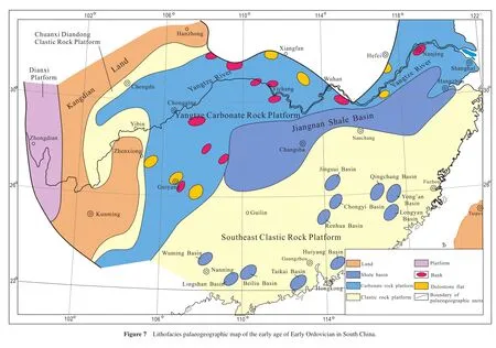
The Yangtze Carbonate Rock Platform occupied the majority of the Yangtze Platform, in which the content of shallow water carbonate rocks was ≥ 50%.Along the west side of the Yangtze Carbonate Rock Platform, or in the narrow area near the Kangdian Land, the content of shallow water carbonate rocks was < 50%.This narrow area can be called the Chuanxi-Diandong Clastic Rock Platform.This Clastic Rock Platform can be viewed as the marginal facies belt of the Yangtze Carbonate Rock Platform.
In the Yangtze Carbonate Rock Platform, there were eleven banks.Besides these banks, there were also some penebanks and embryonic banks, which were not drawn on the map.
In the Yangtze Carbonate Rock Platform, there were seven dolostone flats.
In the Yangtze Carbonate Rock Platform, the high energy banks coexisted with the low energy dolostone flats.This indicates the non-uniformity of the Yangtze Carbonate Rock Platform.
3.3.4Dianxi Platform
Along the west side of the Kangdian Land,i.e., in the area of Zhongdian, Xiaquan and Ninglang, there were mainly distributed shallow water clastic rocks are found.Shallow water carbonate rocks occur as well.Because of the lack of quantitative data, this area can only be called the Dianxi Platform.
This Dianxi Platform in the west side of Kangdian Land was symmetrical with the Yangtze Platform on the east side of Kangdian Land.However, the much smaller Dianxi Platform is not comparable with the larger Yangtze Platform.
3.3.5Southeast Clastic Rock Platform
The shallow water clastic rocks are widely distributed in the broad area on the southeast side of the Jiangnan Basin.This broad area was the Southeast Clastic Rock Platform.It can be simply called the Southeast Platform.The clastic materials of this platform came from the Cathaysia Land, which was located on the east side of this platform.Therefore, the Southeast Clastic Rock Platform can be called the Cathaysia Platform.
In this broad area of the clastic platform, there were eleven isolated shale basins.
This platform was inherited from the Cambrian.The rocks of this platform included fine-grained sandstone,siltstone, shale and slate.The thickness of the Ordovician was about 8000 m.Since the Sinian, via the Cambrian, Ordovician, Silurian, Devonian, and up to the Carboniferous, the total thickness was > 20,000 m.But in these strata, fossils and typical facies indicators were rare.
In this broad Southeast Clastic Rock Platform, involving such a huge thickness of clastic rocks with rare fossils,there is persistent controversy as to whether the sedimentary environment was a shallow water platform sea or deep water sea.
Lu (1979)proposed that this broad area was a subsiding zone on the west side of an uplifting zone (Cathaysia Land).From the Sinian to the Carboniferous, the uplifting zone was constantly uplifted and eroded, and the subsiding zone constantly subsided and received sediments and accumulated a total thickness of more than 20,000 m.This was the result of the Pacif i c Plate being subducted westwards under the Eurasia Plate.Because the uplifting,erosion, subsidence and reception of sediments were continuous and rapid, the sedimentary environment was not beneficial for the survival of organisms, therefore the fossils in the strata were rare.As this sedimentary area was compensative,i.e., the rate of uplifting and subsiding were in equilibrium, therefore the water depth of the sedimentary area was not too deep, although some isolated areas could be deep water areas.Overall, this broad sedimentary area was basically a shallow water platform sea.We agree with the opinion of Lu (1979).
We defined this broad sedimentary area as the Southeast Shallow Water Clastic Rock Platform, or Southeast Clastic Rock Platform, or Southeast Platform, or Cathaysia Platform, in which there were some small isolated deep water basins.The characteristics of this Southeast Platform were different from the typical deep water basin — Jiangnan Basin.
3.3.6Combination of two palaeogeographic systems
As mentioned above, the lithofacies palaeogeography of the early age of Early Ordovician in South China mainly consisted of two lands (Kangdian Land and Cathaysia Land), one basin (Jiangnan Basin), and three platforms(Yangtze Platform, Dianxi Platform and Southeast Platform).
The Dianxi Platform, Yangtze Platform, and Jiangnan Basin had a close relationship with Kangdian Land, because the clastic materials of these platforms were supplied by Kangdian Land.In addition, the slope between the Yangtze Platform and Jiangnan Basin was distinct, the rocks between them commonly displayed transitional features, and gravity f l ow sediments were developed in some places.Therefore, these palaeogeographic units belonged to the same palaeogeographic system,i.e., the Kangdian Palaeogeographic System or Yangtze Palaeogeographic System.
The Southeast Platform and Cathaysia Land had a close relationship, because a great deal of clastic sediments of the Southeast Platform came from the Cathaysia Land.Thus, the Southeast Platform can be called the Cathaysia Platform.The Southeast Platform and Cathaysia Land belonged to the same palaeogeographic system,i.e.,the Cathaysia System.
Wu (2003)discovered ophiolites from these metamorphic rocks of the Banxi Group at Dexing and Yiyang in the northeastern Jiangxi Province.These two areas are located between the Southeast Platform and Jiangnan Basin.This is powerful evidence for the relationship of the Southeast Platform (which belongs to the Cathaysia Plate or Cathaysia Palaeogeographic System)and the Jiangnan Basin (which belongs to the Yangtze Plate or Yangtze Palaeogeographic System).
In summary, the combination of the two palaeogeographic systems,i.e., the Kangdian Palaeogeographic System (or Yangtze Palaeogeographic System)and the Cathaysia Palaeogeographic System, created the basic lithofacies palaeogeographic framework of the early Age of Early Ordovician in South China.This framework was inherited from the Sinian and Cambrian.
4 Composition of quantitative lithofacies palaeogeographic map of the Majiagou Age 1 of Early Ordovician in Ordos, North China
The Ordos in North China is a broad region (Figure 1).It is located to the east of Liupanshan Mountains and Helanshan Mountains, to the south of Yinshan Mountains, to the west of Lüliangshan Mountains, and to the north of Qinling Mountains.It includes the eastern part of Gansu Province, most parts of the Ningxia Autonomous Region, the central and northern part of Shaanxi Province, the western part of the Inner Mongolia Autonomous Region, and the western part of Shanxi Province.Its area is about 320,000 km2.
The Ordovician mainly outcrops at the western margin,southern margin, and eastern part of Ordos.In general, its thickness is between 300-1000 m; the maximum thickness is more than 2000 m.In the central part of Ordos, the Ordovician is covered by the Upper Paleozoic, Mesozoic and Cenozoic, therefore, the distribution and petrography of the Ordovician in Ordos have to rely on drilling and seismic data.
The Lower Ordovician includes the Yeli Formation, Liangjiashan Formation and Majiagou Formations 1, 2, 3, 4,5 and 6 (Table 6).
In the following, we utilize the Majiagou Formation 1 as an example, to demonstrate how to use single factor analysis and multifactor comprehensive mapping method, to compose the quantitative lithofacies palaeogeographic map and to discuss the quantitative single factor maps, quantitative lithofacies palaeogeographic maps and palaeogeographic units in the palaeogeographic maps.
4.1 Single factor analysis
4.1.1The isoline map of thickness (m)
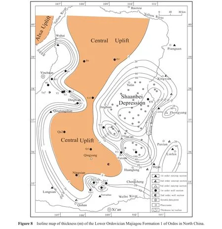
According to the thickness (m)data of 55 sections (9 first order outcrop sections, 4 second order outcrop sections, 2 third order outcrop sections, 20 first order well sections, 2 second order well sections, and 1 third order well section)and 40 seismic sites, the isoline map of thickness(m)of the Lower Ordovician Majiagou Formation 1 of Ordos in North China was composed (Figure 8).
From Figure 8, it can be seen:
1)The Majiagou Formation 1 is distributed along the western margin, southern margin and eastern part of Ordos.In the central part of Ordos, the thickness of Majiagou Formation 1 is zero.This zero is a sedimentary zero.
2)On the western margin and the southern margin of Ordos, the maximum thickness of Majiagou Formation 1 is more than 80 m; they are the Western Margin Depression and Southern Margin Depression respectively.
3)The Shaanbei Depression is located in the eastern part of Ordos, which includes three secondary depressions.The maximum thickness of the three secondary depressions is more than 100 m.
4)In the central part of Ordos, the Majiagou Formation 1 is missing, thus, this central area is the Central Uplift.This Central Uplift from north to south displays the shape of a dumb-bell.The narrow waist of the dumb-bell is near the Well Dt 1.The western wing of the Central Uplift is steep and its eastern wing is gentle.
5)The eastern margin is the Lüliang Uplift and is N-S trending.On this Uplift, the thickness of Majiagou Formation 1 is less than 20 m.In general, the Lüliang Uplift does not belong to Ordos.
6)In the northwestern part of Ordos,i.e., in the western part of Wuhai and Dengkou areas, the Majiagou Formation1 is missing.This area is the Alxa Uplift.Figure 8 only shows a small portion of the Alxa Uplift.
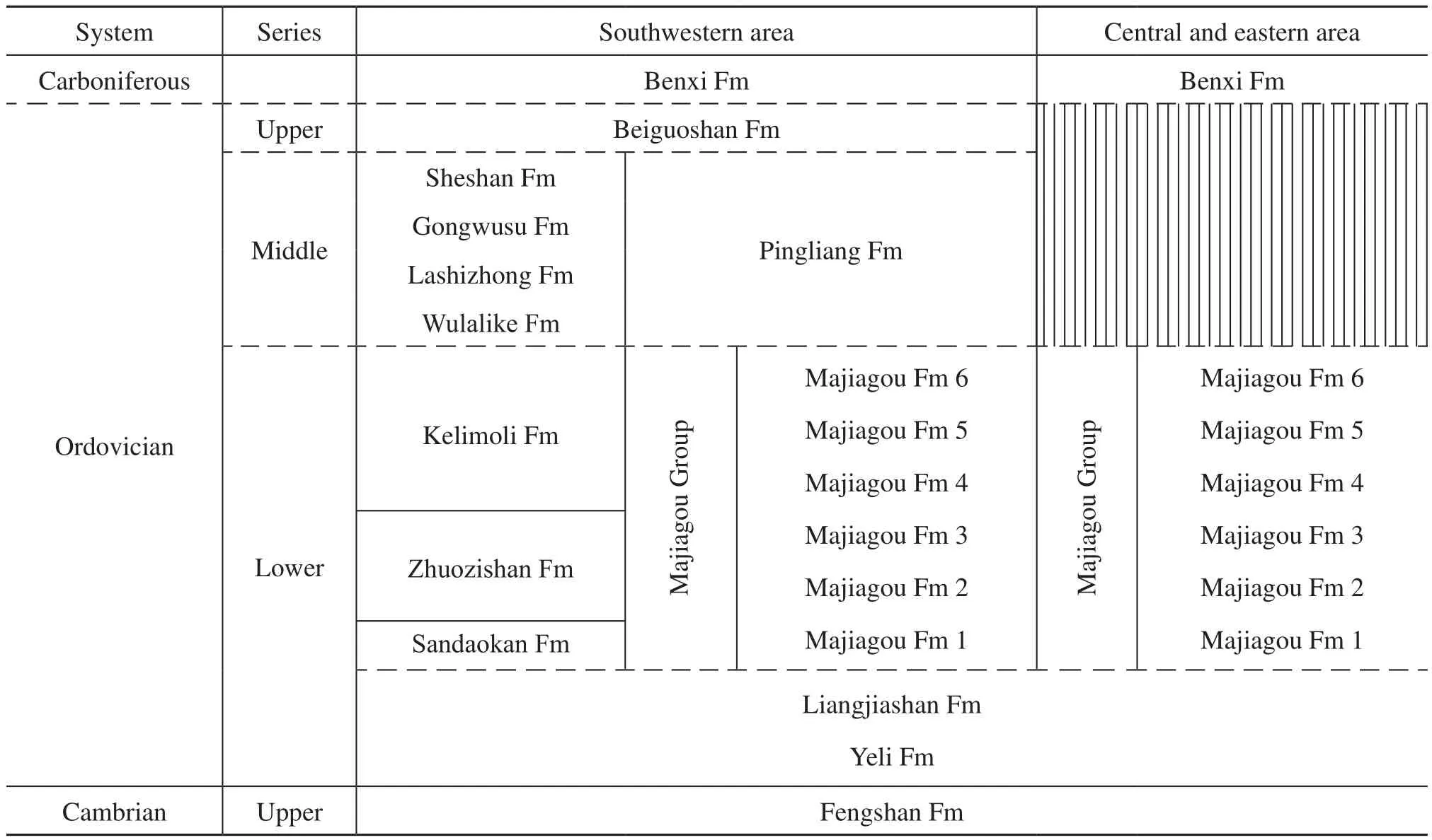
Table 6 Stratigraphy of the Ordos in North China
Overall, the isoline map of thickness of the Majiagou Formation 1 in Ordos ref l ects the framework of palaeotectonics,i.e., one uplift (Central Uplift)and three depressions (Western Margin Depression, Southern Margin Depression, and Shaanbei Depression).
4.1.2Isoline map of content (%)of penecontemporaneous dolostone
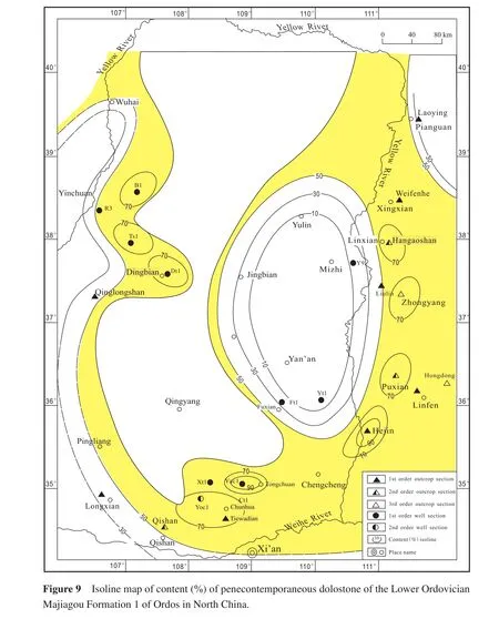
According to the content (%)data of penecontemporaneous dolostone of 23 sections ( 8 first order outcrop sections, 3 second order outcrop sections, 2 third order outcrop sections, 9 first order well sections and 1 second order well section), the isoline map of content (%)of penecontemporaneous dolostone of the Lower Ordovician Majiagou Formation 1 of Ordos in North China was composed(Figure 9).
From Figure 9, it can be seen:
1)In Ordos, penecontemporaneous dolostone is developed very well.In most areas, the content (%)of penecontemporaneous dolostone is > 50%.
2)There are three high content areas,i.e., ① the western area in Well Bu 1, Well Tianshen (Ts)1, and Well Dingtan(Dt)1; ② the eastern area in Linxian, Zhongyang, Puxian,and Hejin ; ③ the southern area in Well Yaocan (Yac)1,Well Yongcan (Yoc)1, and Tiewadian.In these areas, the content of penecontemporaneous dolostone is > 70%; in some places, the content of penecontemporaneous dolostone is > 90%.
3)In the middle eastern area of Yulin, Mizhi, Jingbian and Fuxian, the content of penecontemporaneous dolostone is < 50%.It is an elliptical-shaped low content area and is N-S trending.
4)In the northeastern area,i.e., in Pianguan area, the content of penecontemporaneous dolostone is < 50%.
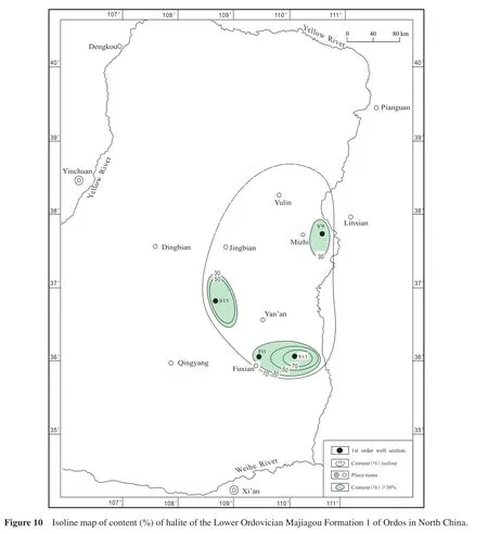
4.1.3Isoline map of content (%)of halite
According to the content (%)data of halite of 4 first order well sections, the isoline map of content (%)of halite of the Lower Ordovician Majiagou Formation 1 of Ordos in North China was composed (Figure 10).
From Figure 10, it can be seen:
1)In Well Yu 9, Well Shaan (S)15, Well Futan (Ft)1, and Well Yitan (Yt)1; the content of halite is 38.8%,59.6%, 46.3%, and 73.4% respectively,i.e., the content of halite is ≥ 30%
2)In Yulin, Mizhi, Jingbian, and Yan’an areas, the content of halite is 29%-10%.
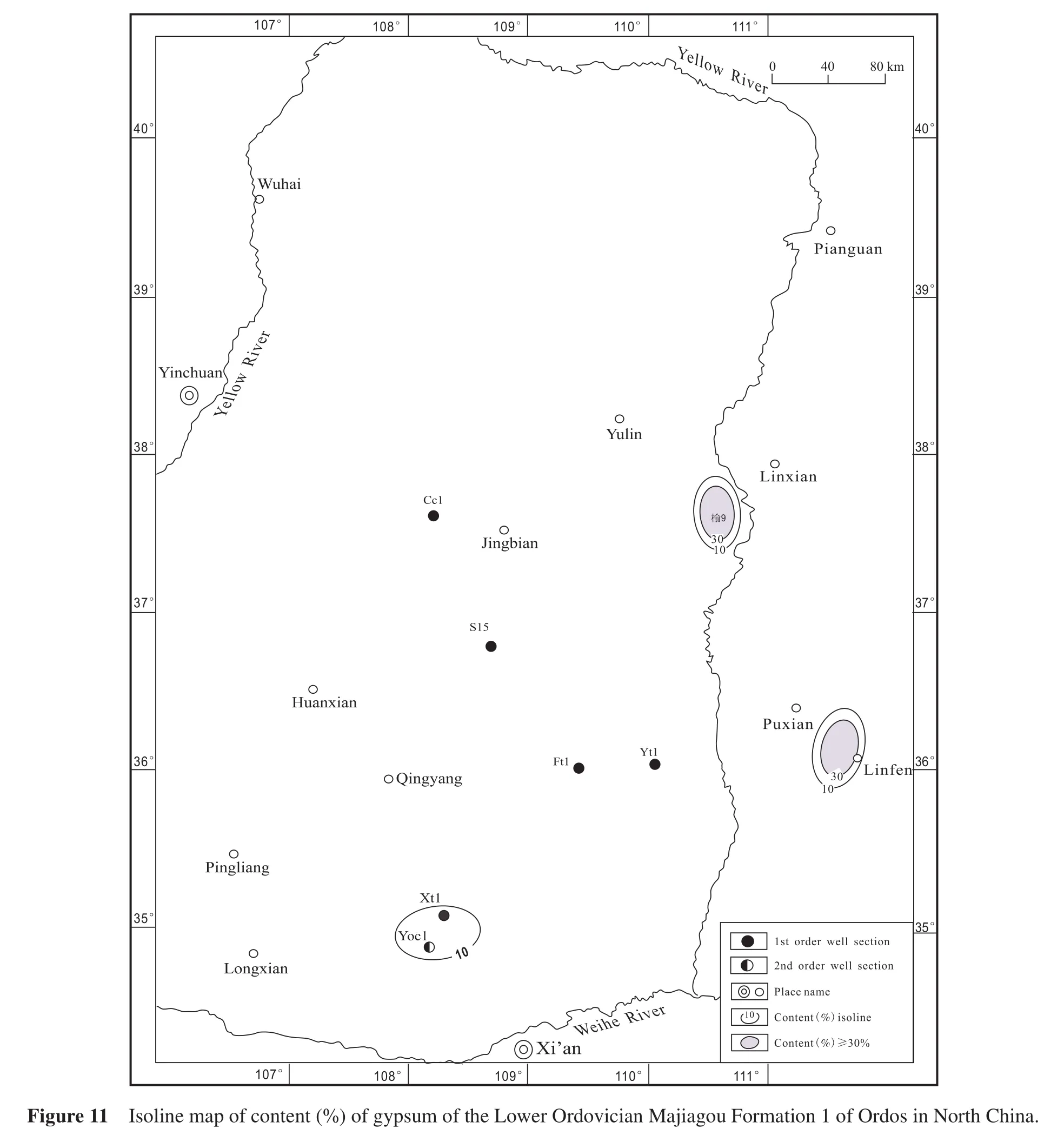
4.1.4Isoline map of content (%)of gypsum
According to the content (%)data of 8 sections (1 first order outcrop section, 6 first order well sections and 1 second order well section), the isoline map of content (%)of gypsum of the Lower Ordovician Majiagou Formation 1 of Ordos in North China was composed(Figure 11).
From Figure 11, it can be seen:
1)In Well Yu 9 and Linfen, the content of gypsum is 30.2% and 46.9% respectively,i.e., the content of gypsum is ≥ 30%.
2)In Well Xuntan (Xt)1, and Well Yoc 1, the content of gypsum is 14% and > 10% respectively,i.e., the content of gypsum is 29%-10%.
4.2 Multifactor comprehensive mapping
Superposing the above single factor maps and comprehensively analyzing them, especially according to some key isolines, the quantitative lithofacies palaeogeographic map of the Early Ordovicion Majiagou Age 1 of Ordos in North China can be composed.
First of all, in the isoline map of thickness (m)of the Majiagou Formation 1 (Figure 8), the areas of zero sedimentary thickness can be defined as lands,i.e., Ordos Land and Alxa Land, and the rest is sea.
In the sea, according to the isoline map of content (%)of penecontemporaneous dolostone (Figure 9), the areas with content of penecontemporaneous dolostone ≥ 50%,can be defined as dolostone flats,i.e., the West Dolostone Flat, Central Dolostone Flat, South Dolostone Flat, and East Dolostone Flat.
In the sea, according to the isoline map of content (%)of halite (Figure 10), the area with content (%)of halite 29%-10%, can be defined as a salt-bearing lake,i.e., the Shaanbei Salt-bearing Lake, and the areas with the content of halite ≥ 30%, can be defined as salt lakes,i.e., the Yu 9 Salt Lake, Shaan 15 (S15)Salt Lake, and Futan 1-Yitan 1(Ft1-Yt1)Salt Lake.
In the sea, according to the isoline map of content(%)of gypsum (Figure 11), the area with content (%)of gypsum ≥ 30%, can be defined as a gypsum lake,i.e.,the Yu 9 Gypsum Lake.Because the Yu 9 Gypsum Lake and the Yu 9 Salt Lake coincided with each other, they can be called Yu 9 Gypsum-Salt Lake.The area with content (%)of gypsum 29%-10%, can be defined as a gypsum-bearing lake,i.e., the Xt 1-Yoc 1 Gypsumbearing Lake.
Finally, the rest of the sea can be defined as open seas,i.e., the West Open Sea, South Open Sea, and East Open Sea.
In this way, the quantitative lithofacies palaeogeographic map of the Early Ordovician Majiagou Age 1 of Ordos in North China (Figure 12)was composed.
In the following, we will discuss the palaeogeographic units of this lithofacies palaeogeographic map.
4.3 Discussion of palaeogeographic units
In the quantitative lithofacies palaeogeographic map of the Early Ordovician Majiagou Age 1 of Ordos in North China (Figure 12), there were lands, dolostone fl ats, salt-bearing lake, salt lakes, gypsum-bearing lakes,gypsum lakes, and open seas.The characteristics of these palaeogeographic units will be discussed in the following.
4.3.1Lands
There were two lands,i.e., Ordos Land and Alxa Land.
In the Yeli Age and Liangjiashan Age, there was only one Land in Ordos,i.e., Ordos Land.However, in the Majiagou Age 1, Ordos Land was separated into two parts and became Alxa Land and reduced Ordos Land.This was a signif i cant alteration.
Alxa Land was only exposed as a small portion in the Jilantai area in the northwestern corner of the study area,and most of Alxa Land was outside of this map.
Ordos Land was located in the middle of Ordos, the shape of which was like a dumb-bell.
4.3.2Dolostone flats
In Ordos, dolostone flats were well developed during Majiagou Age 1.It was an important feature of the Majiagou Age 1.
There were four dolostone flats,i.e., the Central Dolostone Flat, East Dolostone Flat, South Dolostone Flat, and West Dolostone Flat.
The Central Dolostone Flat was located on the eastern side of Ordos Land and on the western side of the Shaanbei Salt-bearing Lake as a narrow N-S trending belt.
The East Dolostone Flat was located on the eastern side of the Shaanbei Salt-bearing Lake.The main rocks were yellowish gray, light gray and gray colour mud-sized dolostone, argillaceous dolostone, mud-sized limestone, and calcareous mudstone.The horizontal bedding was well developed.The mud-sized dolostone with breccias often occurred, which was formed by the collapse of overlying dolostone due to dissolution of gypsum.The typical out-crop sections were in Xingxian, Linxian, Hancheng and Hejin.
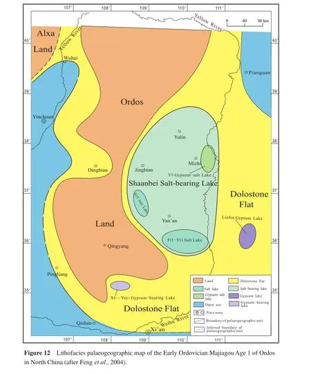
The South Dolostone Flat was located on the southern side of Ordos Land.The major rocks were purplish red,grayish yellow and gray-coloured argillaceous, clay-bearing or argillaceous mud-sized dolostone, silt-sized dolostone, and marlstone, interbedded with shale.Horizontal bedding is well developed.In the nearshore area, the content of terrestrial clay was signif i cant, and therefore the flat became a muddy dolostone flat.
The west dolostone flat was located on the western side of Ordos Land.The main rocks were mud-sized dolostone,muddy mud-sized dolostone and sandy mud-sized dolostone.The contents of terrestrial mud and sand were high.In the nearshore area, the fl at became a muddy dolostone fl at or sandy dolostone fl at.The typical sections were the Zhuozishan Section, Well Bu 1, and Well R 3.
4.3.3Salt-bearing lake and salt lakes
There were one salt-bearing lake and three salt lakes.
The salt-bearing lake was the Shaanbei Salt-bearing Lake, in which the content of halite > 10% and the con-tent of penecontemporaneous dolostone < 50%.The area of this salt-bearing lake was rather large (about 350 km ×200 km), in which there were three salt lakes.
Three salt lakes were Yu 9 Salt Lake, Shaan 15 Salt Lake, and Futan 1-Yitan 1 Salt Lake.Because the Yu 9 Salt Lake coincided with the Yu 9 Gypsum Lake, they can be called Yu 9 Gypsum-Salt Lake.The other two salt lakes contained less gypsum.The main rocks were halite,dark gray thin-bedded, argillaceous mud-sized dolostone,mud-sized limestone, and anhydrite.In Well Shaan 15, the content of halite was 59.6% and the content of gypsum is 0%.In Well Futan 1, the content of halite was 46.3% and the content of gypsum was 9.3%.In Well Yitan 1, the content of halite was 73.4% and the content of gypsum was 2.5%.The three well areas were the sedimentary centres of halite deposition.
4.3.4Gypsum-bearing lake and gypsum lakes
There were one gypsum-bearing lake and two gypsum lakes,i.e., Xt 1-Yoc 1 Gypsum-bearing Lake, Yu 9 Gypsum Lake and Linfen Gypsum Lake.
The Yu 9 Gypsum Lake coincided with Yu 9 Salt Lake,and can be called Yu 9 Gypsum-Salt Lake.This lake had a gypsum content of 30.2% and a halite content of 38.8%.
The Linfen Gypsum Lake was located in Linfen depression.This lake contained gypsum 17.23 m thick, its gypsum content was 46.9%, but was without halite.The main rocks were mud-sized dolostone, anhydrite, light grayish green, thin-bedded calcareous shale, and yellowish green,brecciated mudstone.The content of terrestrial materials was high, and in some place the content of silt can be 20%.This gypsum lake was located in a dolostone flat.Because it was near the open sea with a frequent supply of sea water, the main sediment was gypsum; therefore, it had not reached the sedimentation stage of halite.
4.3.5Open Seas
There were three open seas,i.e., the West Open Sea,South Open Sea, and East Open Sea.These open seas were shallow water carbonate platform seas.
The East Open Sea only occured in the Pianguan area, it was in the northeastern corner of the East Open Sea.
The East Open Sea, South Open Sea and West Open Sea, all of them were the parts of the extensive North China Carbonate Platform.
4.3.6Conclusions
The lithofacies palaeogeography of the Early Ordovician Majiagou Age 1 of Ordos had the following features:
1)The original Ordos Land of the Early Ordovician Liangjiashan Age was separated into two parts in the Majiagou Age 1,i.e., Alxa Land and Ordos Land, and the size of Ordos Land had been signif i cantly decreased.
2)Dolostone flats were widely distributed.
3)In the dolostone flat, the salt lakes and gypsum lakes were well developed.
4)Beyond the dolostone flat, there were open seas,i.e.,carbonate platform seas.
5)There were no banks.
In conclusion, these palaeogeographic units of the Early Ordovician Majiagou Age 1 in Ordos was a palaeogeographic system,i.e., the Ordos Palaeogeographic System.It was a part of North China Palaeogeographic System.This palaeogeographic system was formed by a new cycle of transgression in the beginning of Majiagou Age 1 on a broad surface of the parallel unconformity that was created by the Huaiyuan Movement at the late period of the Liangjiashan Age.After a long duration of sedimentary hiatus and erosion, the Ordos Land had lower relief and was peneplained.It could supply very little terrestrial materials (mainly terrestrial mud)to the adjacent sea.Therefore, in the broad sea outside of Ordos Land, terrestrial clastic rocks were not developed, but the dolostone flats were well developed.In the dolostone flats, there were salt lakes and gypsum lakes.In the platform open seas, there were no banks.This indicates that the water energy of the platform open seas was low.Certainly, this was a unique palaeogeographic environment and different from the early Early Ordovician in South China (Section 3).
5 Characteristics
The lithofacies palaeogeographic maps, made by single factor analysis and multifactor comprehensive mapping method, have three characteristics.
5.1 Quantif i cation
Quantif i cation means that in the lithofacies palaeogeographic maps made by the authors, the division and identif i cation of each palaeogeographic unit are based on quantitative data of single factors and single factor maps.
The precondition of composing a quantitative lithofacies palaeogeographic map is quantitative data.Without a certain amount of quantitative data, it is impossible to compose a quantitative lithofacies palaeogeographic map.
It is not diff i cult to compose a quantitative lithofacies palaeogeographic map by using single factor analysis and the comprehensive mapping method.The diff i culty is to obtain suff i cient quantitative data.
In the previous geologic research results, including regional geological survey reports and their conclusive publication,Regional Geologyof provinces, cities, and autonomous regions, the quantitative data of various single factors are neglected or even absent.In order to compose a quantitative lithofacies palaeogeographic map, we must rely on the previous study results, measure and study outcrop sections again to obtain various quantitative data of each bed, and study thin sections under the microscope to obtain more quantitative data.We must also incorporate previous well data from oilfields and study the thin sections of cores and cuttings under the microscope to obtain the various quantitative data of well sections.This is a necessary and complicated study work.It is diff i cult indeed.
The authors have accomplished the quantitative lithofacies palaeogeographic maps of the Cambrian and Ordovician in North China, South China, and Northwest China,and the Carbornferous, Permian, Early and Middle Triassic of South China.
The authors have also accomplished the lithofacies palaeogeographic maps of the Cambrian and Ordovician of the whole of China (Fenget al., 2004).However, in these maps, only those in North China, South China, and Northwest China are quantitative, the other areas are qualitative,because there were no quantitative data.
All of the above works are less than a half of my original plan to compose quantitative lithofacies palaeogeographic maps of the major geological periods (from Sinian to Triassic)for the whole of China (Feng, 2006).
It will be necessary for more geological experts to make great efforts to do so.
5.2 Multiple orders
Multiple orders are that, in the lithofacies palaeogeographic maps made by the authors, the palaeogeographic units can be subdivided into at least three orders.
The land and the sea are the first order palaeogeographic units.
Usually, the land is not further subdivided.
The sea can be further subdivided into some second order palaeogeographic units, such as platform, basin (or trough), and slope.The platform indicates the shallow water sedimentary area above storm wave base.The basin indicates the deep water sedimentary area below storm wave base.In general, the shape of the basin is almost circular,and the shape of trough is narrowly elongate.The slope is the transitional area between platform and basin (or trough), which basically belongs to the deep water sedimentary area.
In the platform, there are the third order palaeogeographic units,i.e.,the flat, lake, bank, and reef.
In addition, there are some small-size lands and basins in the platform, which can be also the third order palaeogeographic units.
In the basin or trough, there are some smaller lands and platforms, which can also be cosidered the third order palaeogeographic units.
In the third order palaeogeographic units, sometimes there are fourth order palaeogeographic units, however,these fourth order palaeogeographic units are not always defined.
In this paper, some geographical terms, such as continental shelf, shallow sea, semi-deep sea, and deep sea,are not applied, because it is diff i cult to match the marine depositional areas in the palaeogeographic map with these modern geographic terms.Therefore, the relative terms of platform, basin (or trough), and slope are more appropriate.
5.3 Multiple types
Multiple types refer to the many types of palaeogeographic units, such as land, sea, platform, basin, trough,fl at, lake, bank, and reef.According to petrographic characteristics, these palaeogeographic units can be also divided into various sub-types.For example, platform can be further divided into clastic platform, carbonate platform,pyroclastic platform, and clastic carbonate platform.Basin can be further divided into clastic basin, carbonate basin,mudstone basin, chert basin, pyroclastic basin, and f l ysch basin.Trough can be further divided into clastic trough,pyroclastic trough, mudstone trough, chert trough, and f l ysch trough.Flat can be further divided into mud flat, sandy mud flat, dolostone flat, muddy dolostone flat, dolostone mud flat.Lake can be further classif i ed into gypsum lake, gypsum-bearing lake, salt lake, salt-bearing lake,and gypsum-salt lake.Bank can be further divided into sparry bank (penebank, embryonic bank), limemud bank(penebank, embryonic bank), sand-sized intraclastic bank(penebank, embryonic bank), oolitic bank (penebank, embryonic bank), and bioclastic bank (penebank, embryonic bank).Reef can be further divided into sponge reef, coral reef, and algal reef.
Overall, the quantif i cation, multiple orders and multiple types, and especially the quantif i cation, are the most important characteristics of the lithofacies palaeogeographic maps composed by the authors.These character-istics are different from the palaeogeographic maps made by previous researchers.These three characteristics, especially the quantif i cation, are the development and innovation in the palaeogeography by the authors for the past 30 years.This is the contribution to palaeogeography by the authors.
Acknowledgements
The authors heartily thank Professors Ian D.Somerville and Adam D.Woods.They reviewed our paper very carefully and made many contributions to this paper, especially in English.It is that “there are bosom friends afar, the ends of the earth seem near”.
Feng, Z.Z., 1977.A preliminary discussion on the Lower Ordovician lithofacies and paleogeography in North China.Journal of East China Petroleum Institute, (3): 57-79 (in Chinese).
Feng, Z.Z., 1979.A preliminary discussion on the Early Ordovician lithofacies and paleogeography in North China.Scientia Geologica Sinica, (4): 302-313 (in Chinese with English abstract).
Feng, Z.Z., 1987.Methodology on lithofacies paleogeography of Carbonate Rocks.In: Tu, G.Z., (ed).Advances in Science of China.Earth Sciences, 2: 159-175.
Feng, Z.Z., 1989.Lithofacies Paleogeography of Carbonate Rocks.Beijing: Petroleum Industry Press, 1-180 (in Chinese with English preface and contents).
Feng, Z.Z., 1992.Single factor analysis and comprehensive method:Methodology of lithofacies paleogeography.Acta Sedimentologica Sinica, 10(3): 70-77 (in Chinese with English abstract).
Feng, Z.Z., 1993.Sedimentary Petrology (Part 1 and Part 2).Beijing: Petroleum Industry Press, 1-368 (Part 1), 1-327 (Part 2)(in Chinese).
Feng, Z.Z., 1994.Single factor analysis and comprehensive mapping method: Methodology of lithofacies paleogeography.In:Feng, Z.Z., (ed).Sedimentology of China.Beijing: Petroleum Industry Press, 662-685 (in Chinese with English preface and contents).
Feng, Z.Z., 1999a.Struggle for continuous development and innovation of palaeogeography of China: Statement for starting publication of the Journal of Palaeogeography.Journal of Palaeogeography (Chinese Edition), 1(1): 1-6 (in Chinese with English abstract).
Feng, Z.Z., 1999b.Origin, development and future of palaeogeography of China.Journal of Palaeogeography (Chinese Edition),1(2): 1-7 (in Chinese with English abstract).
Feng, Z.Z., 2003.Origin, development, problem and common viewpoint of palaeogeography of China.Journal of Palaeogeography(Chinese Edition), 5(2): 131-143 (in Chinese with English abstract).
Feng, Z.Z., 2004.Single factor analysis and multifactor comprehensive mapping method: Reconstruction of quantitative lithofacies palaeogeography.Journal of Palaeogeography (Chinese Edition),6(1): 3-19 (in Chinese with English abstract).
Feng, Z.Z., 2006.Selected Works of Professor Feng Zengzhao.Beijing: Geological Publishing House, 1-572 (in Chinese with English contents, some articles in English).
Feng, Z.Z., 2009.Definition, content, characteristics and bright spots of palaeogeography of China.Journal of Palaeogeography (Chinese Edition), 11(1): 1-11 (in Chinese with English abstract).
Feng, Z.Z., Bao, Z.D., 2012.Striving for development and innovation of Chinese and international palaeogeography—launch statement forJournal of Palaeogeography.Journal of Palaeogeography, 1(1): 1-3.
Feng, Z.Z., Zhang, J.S., Fei, A.Q., Liu, P.J., 1983.The Ordovician lithofacies and palaeogeography of the Shaanxi-Gansu-Ningxia-Nei Monggol-Shanxi region.Geological Review, 29(1): 17-24.
Feng, Z.Z., Wang, Y.H., Li, S.W., 1988.Study on Lithofacies Paleogeography of Qinglong Group of Lower-Middle Triassic in the Lower Yangtze River Region.Kunming (Yunnan): Yunnan Technological Press, 1-225 (in Chinese with English preface, contents and abstract).
Feng, Z.Z., Wang, Y.H., Zhang, J.S., Zuo, W.Q., Zhang, X.L.,Hong, G.L., Chen, J.X., Wu, S.H., Chen, Y.T., Chi, Y.L., Yang,C.Y., 1990.Lithofacies Paleogeography of Early Paleozoic of North China Platform.Beijing: Geological Publishing House,1-270 (in Chinese with English preface, contents and abstract).
Feng, Z.Z., Chen, J.X., Zhang, J.S., 1991a.Lithofacies Paleogeography of Early Paleozoic of Ordos.Beijing: Geological Publishing House, 1-190, photo plates 1-16 (in Chinese with English preface, contents and abstract).
Feng, Z.Z., He, Y.B., Wu, S.H., Chen, H.C., Qin, Z.S., Qi, D.L.,Liu, Z.H., Peng, D.T., Xu, A.W., Yang, M.D., Huang, M.K.,Guo, B.Y., Chi, Y.L., Bi, Z.Q., Gong, Z.X., Luo, Z., 1991b.Lithofacies Paleogeography of Permian in Middle and Lower Yangtze River Region.Beijing: Geological Publishing House,1-282 (in Chinese with English preface, contents and abstract).
Feng, Z.Z., Bao, Z.D., Li, S.W., 1994a.Lithofacies Paleogeography of Early and Middle Triassic of Yunnan-Guizhou-Guangxi Region.Dongying (Shandong): Petroleum University Press, 1-180(in Chinese with English preface, contents and abstract).
Feng, Z.Z., Jin, Z.K., Yang, Y.Q., 1994b.Lithofacies Paleogeography of Permian of Yunnan-Guizhou-Guangxi Region.Beijing:Geological Publishing House, 1-146 (in Chinese with English preface, contents and abstract).
Feng, Z.Z., Bao, Z.D., Li, S.W., 1997a.Lithofacies Paleogeography of Early and Middle Triassic of South China.Beijing: Petroleum Industry Press, 1-222, photo plates 1-28, color maps 1-4 (in Chinese with English preface, contents and abstract).
Feng, Z.Z., Yang, Y.Q., Jin, Z.K., Li, S.W., Bao, Z.D., 1997b.Lithofacies Paleogeography of Permian of South China.Dongy-ing (Shandong): Petroleum University Press, 1-242, color maps 1-4 (in Chinese with English preface, contents and abstract).
Feng, Z.Z., Bao, Z.D., Zhang, Y.S., Tan, J., Kang, Q.F., Han, Z.,Wang, Y.X., Zhang, C.L., Han, Y.C., 1998a.Stratigraphy Petrology Lithofacies Paleogeography of Ordovician in Ordos.Beijing: Geological Publishing House, 1-144, photo plates 8 (in Chinese with English contents and abstract).
Feng, Z.Z., Yang, Y.Q., Bao, Z.D., Jin, Z.K., 1998b.Lithofacies Paleogeography of Carboniferous in South China.Beijing: Geological Publishing House, 1-124, photo plates 9, color maps 4(in Chinese with English preface, contents and abstract).
Feng, Z.Z., Zhang, J.Q., Wang, G.L., Jin, Z.K., Bao, Z.D., 2000.Lithofacies Paleogeography of the Cambrian and Ordovician in Northwest China.Dongying (Shandong): Petroleum University Press, 1-234 (in Chinese with English preface, contents and abstract).
Feng, Z.Z., Peng, Y.M., Jin, Z.K., Jiang, P.L., Bao, Z.D., Luo, Z.,Ju, T.Y., Tian, H.Q., Wang, H., 2001.Lithofacies Paleogeography of the Cambrian and Ordovician in South China.Beijing:Geological Publishing House, 1-221, color maps 1-10, color photo plates 1-8 (in Chinese with English preface, contents and abstract).
Feng, Z.Z., Peng, Y.M., Jin, Z.K., Bao, Z.D., 2004.Lithofacies Paleogeography of the Cambrian and Ordovician in China.Beijing: Petroleum Industry Press, 1-233, color maps 42, color photo plates 1-8 (in Chinese with English preface, contents and abstract).
Feng, Z.Z., Bao, Z.D., Wu, M.B., Jin, Z.K., Shi, X.Z., 2005.Lithofacies Paleogeography of the Cambrian and Ordovician in Tarim Area.Beijing: Geological Publishing House, 1-186, color maps 1-8, color photo plates 1-8 (in Chinese with English preface,contents and abstract).
Feng, Z.Z., Zheng, X.J., Jin, Z.K., 2012.Palaeogeography of China.Journal of Palaeogeography, 1(2): 91-104.
Grabau, A.W., 1924-1928.Stratigraphy of China (Part l and Part 2).Peking: Geological Survey of China, 1-528 (Part 1), 1-774(Part 2).
Guan, S.C., Yan, H.Y., Qiu, D.Z., Wang, S.D., Chen, X.Q., Zhou,J.C., Yuan, F.T., Chen, S.Q., 1984.The Changes of Land and Sea, Marine Sedimentary Facies and Hydrocarbon in China.Beijing: Science Press, 1-104 (in Chinese with English abstract).
Hsieh, C.Y., 1948.Palaeogeography as a guide to mineral exploration.Bulletin of the Geological Society of China, 28(1-2): 1-11.
Huang, T.K., 1945.On major tectonic forms of China.Geological Memoirs, Ser.A., No.20: 1-165.
Liu, B.J., Xu, X.S., 1994.Atlas of Lithofacies Palaeogeography of South China.Beijing: Science Press, 1-188 (in Chinese).
Liu, B.J., Xu, X.S., Pan, X.N., Huang, H.Q., Xu, Q., 1993.Crust Evolution and Mineralization of Palaeocontinent Sediments in Southern China.Beijing: Science Press, 1-236 (in Chinese).
Liu, B.P., 1986.Textbook of Historical Geology.Beijing: Geological Publishing House, 1-408 (in Chinese).
Liu, H.Y., 1955.Atlas of Palaeogeography of China.Beijing: Science Press, 1-69 (in Chinese).
Lu, Y.H., 1979.Sedimentary Mineral Resources of Cambrian in China and “Biotic-Environment Cybernetics”.Beijing: Geological Publishing House, 1-75 (in Chinese).
Lu, Y.H., Zhu, Z.L., Qian, Y.Y., 1965.Cambrian palaeogeography and lithofacies of China.Acta Geologica Sinica, 45(4): 349-357(in Chinese with English abstract).
Ma, Y.S., Chen, H.D., Wang, G.L., 2009.Sequence Stratigraphy and Palaeogeography of South China.Beijing: Science Press,1-603 (in Chinese).
Mineralogy and Petrology Section of Beijing Petroleum Institute,1961.Sedimentary Petrology.Beijing: China Industry Press,1-265 (in Chinese).
Mineralogy and Petrology Section of East China Petroleum Institute,1982.Sedimentary Petrology (Part 1 and Part 2).Beijing: Petroleum Industry Press, 1-290 (Part 1), 1-256 (Part 2)(in Chinese).
Wang, H.Z., 1956.Textbook of Historical Geology.Beijing: Geological Publishing House, 1-396 (in Chinese).
Wang, H.Z., 1985.Atlas of the Palaeogeography of China.Beijing:Cartographic Publishing House, 1-85 (in Chinese), 1-28 (in English), maps 1-143.
Wang, H.Z., Yang, S.N., Liu, B.P., 1990.Tectonopalaeogeography and Biopalaeogeography of China and Adjacent Regions.Wuhan(Hubei): China University of Geosciences Press, 1-347 (in Chinese with English contents and abstract).
Wu, H.R., 2003.Tectonopalaeogeographic analysis of the geologic problems related to ophiolitic belt in northeastern Jiangxi Province.Journal of Palaeogeography (Chinese Edition), 5(3): 328-342 (in Chinese with English abstract).
Yin, H.F., 1988.Biopalaeogeography of China.Wuhan (Hubei):China University of Geosciences Press, 1-329 (in Chinese).
Yin, H.F., Wu, S.B., Du, Y.S., Peng, Y.Q., 1999.South China defined as part of Tethyan Archipelagic Ocean System.Earth Sciences (Journal of China University of Geosciences), 24(1): 1-12(in Chinese).
Zeng, Y.F., Chen, H.D., Zheng, R.C., Gao, J.H., Zheng, H.R.,1996.Sedimentary of Palaeocontinent and Continental Margin in China.Chengdu (Sichuan): Sichuan Science and Technology Press, 1-502 (in Chinese, some articles in English or with English abstract).
Zheng, H.R., Hu, Z.Q., 2010.Atlas of Tectoniclithofacies Palaeogeography of Pre-Mesozoic in China.Beijing: Geological Publishing House, 1-194 (in Chinese).
Zhou, Z.Y., Lin, H.L., 1995.Stratigraphy, Paleogeography and Plate Tectonic in Northwest China.Nanjing (Jiangsu): Nanjing University Press, 1-299 (in Chinese).
猜你喜欢
杂志排行

Journal of Palaeogeography的其它文章
- Congratulations on success of the 1st International Palaeogeography Conference
- 19th International Sedimentological Congress 2014 in Geneva: Theme 12—Palaeogeography
- Diversity patterns and palaeobiogeographical relationships of latest Devonian-Lower Carboniferous foraminifers from South China: What is global,what is local?
- The ichnofacies and ichnoassemblages in terrestrial deposits of China
- Patterns of fossil distributions within their environmental context from the Middle Triassic in South Canyon, Central Nevada, USA
- Foraminiferal biostratigraphy of lignite mines of Kutch, India: Age of lignite and fossil vertebrates