青藏高原春季感热异常对中国北方雨季降水影响的数值研究
2014-07-02李新周刘晓东
李新周,刘晓东
(1. 中国科学院地球环境研究所 黄土与第四纪地质国家重点实验室,西安 710075;2.中国科学院青藏高原地球科学卓越创新中心,北京 100101)
青藏高原春季感热异常对中国北方雨季降水影响的数值研究
李新周1,2,刘晓东1,2
(1. 中国科学院地球环境研究所 黄土与第四纪地质国家重点实验室,西安 710075;2.中国科学院青藏高原地球科学卓越创新中心,北京 100101)
青藏高原作为一个抬升的热源对亚洲季风演化及其周边区域降水都有着深刻影响,近年来高原春季冷暖异常引起学者们的高度关注。本文利用NCEP II和NOAA资料分析了近33年春季高原感热通量、东亚夏季风北缘及中国北方雨季降水年际年代际变化特征,进而利用公用大气模式CAM5进行了关闭春季高原感热的敏感性数值试验。主要结论如下:近33年来春季高原感热通量呈下降趋势,与中国北方雨季(7—8月)降水显著正相关,达到95%显著性水平。春季高原冷(2000—2011年,简称CTP)较暖时段(1986—1997年,简称WTP)感热通量平均降低20 W·m−2左右。相应地,夏季风北缘平均南退3个纬度左右,导致中国北方雨季大气可降水和降水率也分别减少2.44 kg·m−2和1.09 mm·d−1。数值试验结果显示,当关闭春季(3月1日至5月15日)高原感热对大气加热时,东亚夏季风整体爆发时间明显推迟,夏季风最北位置偏南2~3个纬度,中国北方整体降水减弱。这种因春季高原热源异常引起大气环流的改变是中国北方雨季降水多寡的主要原因之一,可以作为中国北方区域雨季降水的关键因子。
青藏高原;春季感热加热;雨季降水;东亚夏季风;数值模拟
1 Introduction
As an elevated heat source, the Tibetan Plateau (TP) plays a important role in regulating the outbreak and development of Asian monsoons, which have received significant attention from meteorological scholars. As early as the 1950s, Ye et al(1957) recognized TP as a heat source in summer and a heat sink in winter. An in-depth study conducted over the past several decades, and has achieved fruitful outcomes based on the datum of the 1stand 2ndscientif c experiments on TP, instrumental observations and satellite remote sensing. The studies have explicitly noted that TP play a significant role in the outbreak and development of the Asian monsoon, and the formation and maintenance of summer circulation (Luo and Yanai, 1984; Huang, 1985; Wu, 2004; Duan et al, 2005; Zhao et al, 2007; Zhou et al, 2009; Liu et al, 2011). Recent studies continue to emphasize that the thermo-dynamic effect of TP during the spring not only provides a favorable background condition for the outbreak of the Asian monsoon (Liu et al, 2002), but also can be used as a factor to predict the July precipitation in the Yangtze River area of China (Duan et al, 2005), with a significant impact on the spring and summer precipitation in southeast China (Wen et al, 2010; Liu and Wang, 2011).
The Asian monsoon is the most powerful and complicated system in the world, and affects the survival of more than half of the world’s population. Therefore, it is both scientifically significant and of practical value to accurately understand the development of the Asian monsoon. The East Asian summer monsoon (EASM) is an important circulation system of the Asian monsoon, and its strength and north margin (NSM) determine the amount of rainy season precipitation in North China. Jiang et al. (2008) considered that the strong EASM causes more precipitation in North China, Huaihe River Basin and Meiyu region, based on the station observations and normalized datum. The weak EASM results in more precipitation in the Yangtze River basin and less precipitation at the NSM (Qian et al, 2009). The north-south swing of the NSM marks the transition zone between wet and dry in China , where the annual precipitation is 200 ~ 400 mm (Qiang et al, 2004; Li et al, 2012).
The outbreak and development of the EASM and its northward are closely related to the spring heat source over TP. The studies by Wu and Zhang (1998) and Ueda and Yasunari (1998) suggest that the development of the EASM is determined by the meridional temperature gradient over TP and its surrounding area. Atmospheric warming over TP during the spring is mainly attributed to the surface sensible heat flux (SSHF) (Li and Yanai, 1996). The SSHF over TP presents a signif cant downward trend during the past 30 years based on NCEP II (Duan and Wu, 2008; Guo et al, 2011); correspondingly, the rainy season precipitation significantly has a decreasing trend in North China (Liu et al, 2006; Ma, 2007). There seems to be some correspondence in them. Accordingly, in this study, the correlations betweenSSHF over TP, NSM and rainy season precipitation in North China are analyzed, using the NCEP-DOE Reanalysis II (NCEP II) and National Oceanic and Atmospheric Administration (NOAA) datum. Further, the effects of the SSHF over TP on the EASM onset, the location of NSM, and the precipitation in North China, are checked by the latest global atmospheric circulation model, to f nd the prediction factor of the rainy season precipitation in North China.
2 Data analysis
2.1 Data description
This study employs the NCEP II including the daily surface sensible heat flux, atmospheric precipitation, and wind speed (Kanamitsu et al, 2002). Additionally, the daily precipitation data (0.5°×0.5°) is provided by NOAA (Chen et al, 2008). The time span is from 1979 to 2011. The definition of NSM is referenced Tang et al(2010). The atmospheric precipitation provided by the NCEP II data is less than that given by the data of the European Centre for Medium-Range Weather Forecasts (ECMWF) adopted by Tang et al.; thus, this study uses the difference of 35~45 kg·m−2between the maximum and minimum of the daily atmospheric precipitable water to represent the NSM (see the shaded area in Fig. 1d).
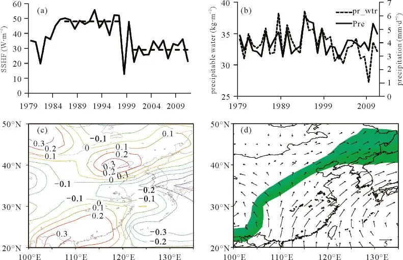
Fig.1 The SSHF anomaly over TP and its relationship with the rainy season precipitation in North China(a) The sequence of the variation in SSHF over TP (W·m−2); (b) The sequences of atmospheric precipitation (mm) and the precipitable water (kg·m−2) for July-August in North China; (c) The distribution of the correlation coeff cients between the SSHF over TP and the atmospheric precipitation for July-August; (d) The NSM (shaded area) and the wind f eld of July averaged for 1979—2011.
2.2 Relationships between the SSHF and the precipitation
Generally, the SSHF is the main contributor to TP which determines the outbreak and development of the EASM. Latent heating dominates after mid-May. Therefore, the average of SSHF is selected during March 1stto May 15thto reflect the heating intensity of TP (Liu and Wang, 2011). The range of TP is 80º~100ºE, 25º~36ºN. Figure 1a shows the evolving sequence of the SSHF over TP during 1979—2011. The SSHF is higher during 1980s to 1990s than 2000s, and the average of SSHF decreases from 47.97 W·m−2in 1990s to 29 W·m−2in 2000s. This study defines the 12 consecutive years from 1986 to 1997 with a relatively high SSHF as the warm time period (WTP) of TP; correspondingly, the12 consecutive years from 2000 to 2011 are def ned as the cold time period (CTP). In the following analysis, the values used refer to the average of the 12 years of WTP and CTP unless otherwise specif ed. A linear trend analysis of 1979—2011 (not shown) indicates that the SSHF in most parts of TP (2000 meters or more above sea level) has a downward trend, which is most pronounced in the middle and eastern parts of TP. The average SSHF in the CTP is lower than the WTP by approximately 20 W·m−2.
The rainy season precipitation in North China is mainly concentrated from July—August and accounts for approximately 40% of the annual total precipitation. The sequences of average atmospheric precipitation and precipitable water of July—August in North China (113º~125ºS, 37º~43ºN) (Fig. 1b) exhibit similar characteristics with the SSHF over TP. The average atmospheric precipitation (precipitable water) for July—August in the WTP is 4.25 mm·d−1(34.26 kg·m−2); in the CTP, the value is 3.91 mm·d−1(31.82 kg·m−2). The difference of atmospheric precipitation (precipitable water) between the CTP and WTP is 1.09 mm·d−1(2.44 kg·m−2). The correlation coefficients between the SSHF over TP and monthly average atmospheric precipitation and precipitable water are computed during 1979 to 2011, a positive for July—August (Fig. 1c) in North China, with a significance level of 95%, irrelevant for other seasons (not shown). Figure 1d shows the characteristics of the NSM averaged for 1979—2011, where the shaded area in the f g.1d is the NSM (with an atmospheric precipitation of 35~45 kg·m−2). Meanwhile, the f g.1d also shows the average 850hPa wind field in July for 1979—2011. The position of the NSM is consistent with the wind field, which indicates that it is reasonable to define the NSM based on the atmospheric precipitable water. This result suggests that there is a close relationship between the SSHF over TP, the NSM, and the rainy season precipitation in North China, which is worth further analysis and study.
2.3 Decadal relationships
The strength of the EASM and its farthest position determine the spatial characteristics of the NSM. The average NSM and the wind field of July (Figs. 2a and b) in the WTP and CTP indicate that the 850 hPa wind field of July is generally consistent with the NSM. The overall NSM in the WTP is shifted northward, while southward in the CTP. The average NSM in the CTP retreats southward by approximately 2 latitudes, and the maximum difference between CTP and WTP is up to 3 latitudes. There is northerly wind anomaly over eastern China based on differences between CTP and WTP (Fig. 2c). The difference in atmospheric precipitable water between the CTP and WTP near the NSM is as large as 3 kg·m−2; moreover, the precipitation decreases by approximately 2 mm·d−1(Fig. 2d). Therefore, the warmth and coldness over TP in spring directly affect the position of the NSM and play a regulatory role with respect to the precipitation, can be used to predict the rainy season precipitation in North China.
3 Numerical experiments
3.1 Descriptions
The global atmospheric circulation model used in this study is the community atmosphere model version 5 (CAM5) (Neale et al, 2010), including the atmosphere and land modules, which is a sub-module of the Community Earth System Model (CESM1.0), released by the U.S. National Center for Atmospheric Research (NCAR) in the summer of 2010 (Vertenstein et al, 2010). Following the development in the past decades, CAM5 has achieved significant improvements, especially with respect to the impact of anthropogenic emissions on the climate in the boundary layer and radiation process, which could not be carefully considered in the previous versions.
Based on the above analysis, to further clarify the main contribution of the SSHF over TP to the NSM and the rainy season precipitation in North China, we use the up-to-date version of CAM5 to conduct a control experiment (without any changing parameters, referred to as CTL) and a sensitive experiment in which the SSHF over TP is shut off (referred to asTPoff). In TPoff experiment, the sensible heat flux is zero in TP area with elevations above 2000 meters from March 1stto May 15th. That is, TP surface does not transfer sensible heat to the atmosphere in the numerical integration, and the land-atmosphere heat exchange stops (Guo et al, 2011). In both numerical experiments, the horizontal resolutions are 1.9 º×2.5º, with 30 vertical layers. Every experiment integrates over 12 consecutive years, and the average for the last 10 years is used for the analysis.
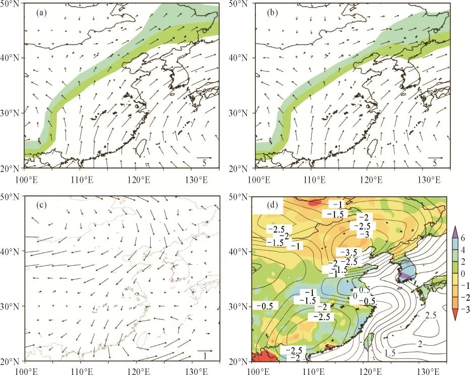
Fig.2 The results of reanalysis(a) The average NSM and the wind f eld at 850 hPa in July in the WTP; (b) The same as (a) but for CTP;(c) The difference in the wind f eld at 850 hPa between CTP and WTP in July over TP;(d) The difference in atmospheric precipitation (shaded area, mm·d−1) and the precipitable water (contour, kg·m−2) between CTP and WTP.
3.2 Experimental results
The CAM5 numerical model significantly reproduces the spatial and temporal distribution of the SSHF over TP, and the values are slightly larger than the NCEP II data. The spatial and temporal variations in the atmospheric precipitation and precipitable water in East Asia are generally consistent with the reanalysis data (not shown). So, CAM5 can be used to conduct the numerical sensitivity experiment over TP.
The SSHF over TP is one of the main factors affecting the outbreak of the Asian monsoon and its advancing. Figures 3a and b show the NSM (the shaded area) and the 850 hPa wind f eld in July in CTL and TPoff. The position of the NSM in the CTL is shifted farther to the north in comparison with NCEP, and the northward advance of the EASM in July is also stronger, while the general distribution is consistent with the NCEP II. In comparison with the CTL, the NSM in TPoff is shifted significantly southward by 2~3 latitude degrees, and the wind field of July isalso weaker, which is consistent with the results of the reanalysis of the NCEP II. The difference between the wind f elds of TPoff and CTL (Fig. 3c) indicates that the strength of the EASM in July signif cantly decreases, a northerly wind anomaly appearing in North China. For July—August, the atmospheric precipitation and precipitable water decrease by 2 mm·d−1and 2 kg·m−2, respectively, due to the impact of the SSHF over TP (Fig. 3d), which is consistent with the results of the reanalysis data. The center of the largest difference is slightly different from the NCEP II data, which most likely occurs as a result of the systematic error of the CAM5. A comparison of numerical experiments clearly indicates that the SSHF over TP has a signif cant regulatory impact on the NSM and rainy season precipitation in North China and can be considered comprehensively in future climate predictions as a factor affecting rainy season precipitation in North China.

Fig.3 The results of numerical experiments The characteristics of the variations in the multi-year average NSM and the rainy season precipitation in North China, simulated by the CAM5.(a) The CTL; (b) TPoff; (c) wind f eld anomaly (TPoff-CTL);(d) atmospheric precipitation (shaded area, mm·d−1) and the precipitable water (contour, kg·m−2) anomaly.
In Asia, the summer monsoon first outbreaks in early to mid-April in the area of the Bay of Bengal (Wu and Zhang, 1998); then, the South China Sea monsoon develops in early May. The CTL simulated the outbreak of the summer monsoon well (Fig. 4a), which is consistent with the observational data. But, in the TPoff, the timing of the outbreak of the summer monsoon in the Bay of Bengal is postponed to late April (Fig. 4b), and the development of the South China Sea monsoon is also delayed to late May. This conf rm that the SSHF over TP plays a key role in determining the outbreak time of the EASM. The advancing of the EASM is also constrained by the SSHF over TP. The cross-equatorial airflow issignificantly weakened in TPoff. A northerly wind anomaly appears in eastern China, with significant weakening of EASM. In summary, the SSHF over TP plays a key role in determining the outbreak time, the advancing, and the north margin position of the EASM. Therefore, the change in atmospheric circulation caused by the heat source anomaly over TP in spring is one of the key factors of the rainy season in North China.
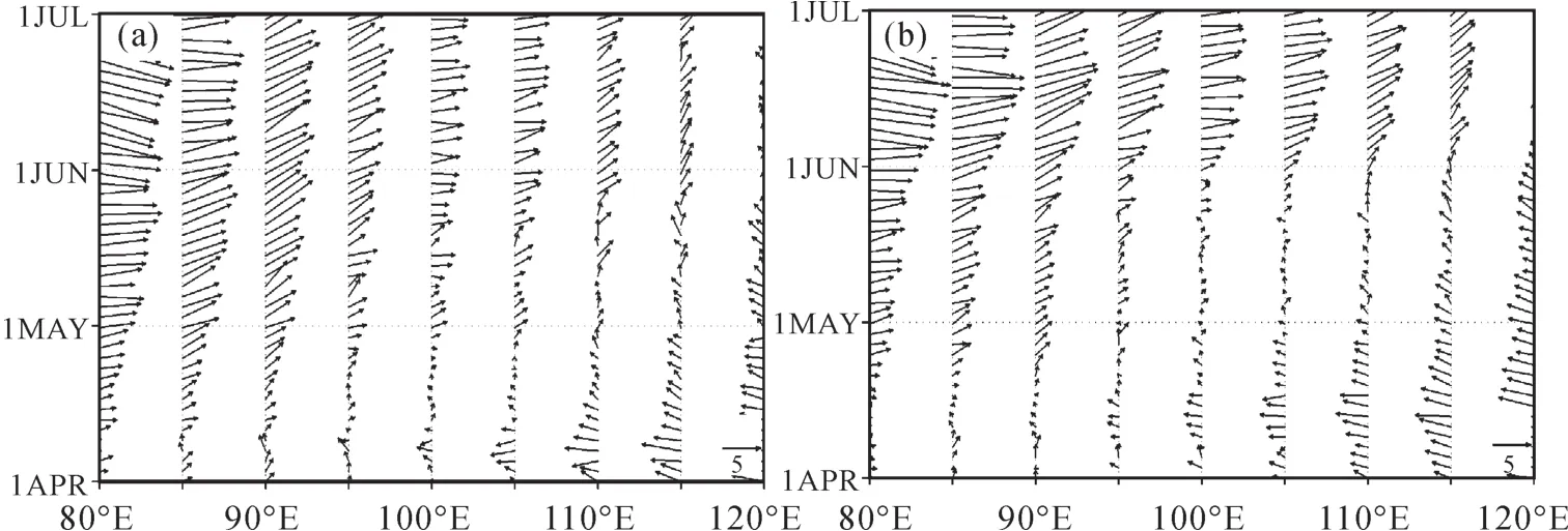
Fig.4 The timing of the EASM onset, as shown by the CAM5(a) The CTL; (b) TPoff
4 Conclusions
The main conclusions are described in the following:
1) The reanalysis data indicates that in 1979—2011, the SSHF over TP exhibits a significant downward trend, has a positive correlation with atmospheric precipitation and the precipitable water for July—August in North China. The significance level of this correlation is 95% for July—August, while the correlation for other seasons is not significant. The SSHF decreased from 47.97 W·m−2in 1990s to 29 W·m−2in 2000s. On average, the SSHF in the CTP decreased by approximately 20 W·m−2in comparison with the WTP. The reanalyzed data indicate that the average atmospheric precipitation and the precipitable water of the rainy season (July—August) in the CTP decrease by 1.09 mm·d−1and 2.44 kg·m−2in North China, respectively, compared with the WTP. The rainy season precipitation in North China is closely related to the SSHF anomaly over TP.
2) The NCEP II indicates that the maximum difference of the NSM between the WTP and CTP is as much as 3 degrees of latitude. When TP is warm during spring, the EASM is stronger with significantly more northward advancement, and the opposite situation occurs when TP is cold during spring. The fluctuations of the EASM and northsouth swing of the NSM caused by the coldness and warmth of TP in spring are the main reasons for the rainy season precipitation anomaly in North China.
3) The numerical experiments indicate that when the SSHF over TP is shut off, that is, when heat is no longer transferred from the surface of TP to the atmosphere from March 1stto May 15th, the timing of the EASM onset is postponed, and the strength of the monsoon is weakened. The EASM also retreats further to the south, and its North edge is shifted southward by 2~3 degrees of latitude. Due to the shut-off of the SSHF over TP, the rainy season atmospheric precipitation and the precipitable water in North China are decreased by 2 mm·d−1and 2 kg·m−2, respectively. The analysis of the circulation field indicates that the SSHF anomaly over TP is the primary contributor to the outbreak time and the magnitude of northward advancement of the EASM. The change of this circulation field is one of the factors that ultimately determine the rainy season precipitation in North China. It can be observed that the SSHF over TP is the main factor affecting the outbreak and development of the EASM, and can be used as a key factor for the prediction of rainy seasonprecipitation in North China.
4) This study only comparatively analyzed the impact of the SSHF anomaly over TP on the EASM and rainy season precipitation in North China. The analysis was performed by means of shutting off the atmospheric heating by the SSHF over TP, while it remains unknown how the SSHF anomaly over TP contiguously affects the development of the EASM. It is necessary to apply various observational data and high-resolution numerical experiments to explain the impact mechanism, which is the main focus of our future works.
Chen M Y, Shi W, Xie P P, et al. 2008. Assessing objective techniques for gauge-based analyses of global daily precipitation [J]. Journal of Geophysical Research, 113, D04110: 1–13.
Duan A M, Wu G X. 2008. Weaking trend in the atmospheric heat source over the Tibetan Plateau during recent decades. part I: observations [J]. Journal of Climate, 21: 3149–3164.
Duan A M, Liu Y M, Wu G X. 2005. Heating status of the Tibetan Plateau from April to June and rainfall and atmospheric circulation anomaly over East Asia in midsummer [J]. Science China Earth Sciences, 48(2): 250–257.
横向的基层农技人员轮岗制度,有别于“转岗”从事行政工作,“转岗”会有意无意中淡化了其农机人员本职身份。轮岗制度是通过县农口有关部门统筹安排,根据工作需要,优化配置基层农技人员人力资源,保证基层农技人才在乡乡之间、县乡之间的横向纵向流动,本质是强调专业全面化,从更广视角做精做细农技推广工作。
Guo X F, Yang K, Chen Y Y. 2011. Weakening sensible heat source over the Tibetan Plateau revisited: effects of the land-atmosphere thermal coupling [J]. Theoretical and Applied Climatology, 104: 1–12.
Huang R H. 1985. The Inf uence of the heat source anomaly over Tibetan Plateau on the northern Hemispheric circulation anomalies [J]. Acta Meteorologica Sinica, 43(2): 208 –220. (in Chinese)
Jiang Z, Yang S, He J, et al. 2008. Interdecadal variations of East Asian summer monsoon northward propagation and inf uences on summer precipitation over East China [J]. Meteorology and Atmospheric Physics, 100: 101–119.
Kanamitsu M, Ebisuzaki W, Woollen J, et al. 2002. NCEP/ DOE AMIP-II Reanalysis (R-2) [J]. American Meteorological Society, 83: 1631–1643.
Li C, Yanai M. 1996. The onset and interannual variability of the Asian summer monsoon in relation to land-sea thermal contrast [J]. Journal of Climate, 9: 358 –375.
Li X Z, Ma Z G, Liu X D, et al. 2006, Inter-decadal Characteristics of Aridification over Northern China in Association with variations of the Atmospheric Circulation during the Last Fifty Years [J]. Chinese Journal of Atmospheric Sciences, 30(4):401– 409.
Li Y, Wang N A, Li Z L, et al. 2012. Holocene climate cycles in northwest margin of Asian monsoon [J]. Chinese Geograph Science, 22(4): 450 – 461.
Liu C L, Xie G D, Huang H Q. 2006. Shring and drying up of Baiyangdian lake wetland: a natural or human cause? [J]. Chinese Geographical Scence, 16(4): 314 –319.
Liu P, Qian Y F, Yan M. 2011. The relation between the underlying surface thermal anomalies and the onset and intensity of the south China sea summer monsoon [J]. Journal of Tropical Meteorology , 27(2): 209–218. (in Chinese)
Liu X, Wu G X, Liu Y M, et al. 2002. Diabatic heating over the Tibetan Plateau and the seasonal variations of the Asian circulation and summer monsoon onset [J]. Chinese Journal of Atmospheric Sciences, 26(6): 781–793. (in Chinese)
Luo H B, Yanai M. 1984. The large-scale circulation and heat sources over the Tibetan Plateau and surrounding areas during the early summer of 1979. Part I: precipitation and Kinematic analyses [J]. Monthly Weather Review, 112: 966 – 989.
Ma Z G. 2007. The interdecadal trend and shift of dry/wet over the central part of North China and their relationship to the Pacific Decadal Oscillation (PDO) [J]. Chinese Science Bulletin, 52: 2130–2139.
Neale R B, Chen C C, Gettelman A, et al. 2010. Description of the NCAR Community Atmosphere Model (CAM5.0) [R]. Technical Report, NCAR.
Qian W H, Ding T, Hu H R, et al. 2009. An overview of drywet climate variability among monsoon-westerly regionsand the monsoon northernmost marginal active zone in China [J]. Adavances in Atmospheric Sciences, 26(4): 630 – 641.
Qiang M R, Li S, Gao S Y. 2004. Evidence for abrupt cliamtic changes on northwstern margin of East Asian monsoon region during last deglaciation [J]. Chinese Geographical Science, 14(2): 117–121.
Tang X, Chen B D, Liang P, et al. 2010. Definition and features of the north edeg of the East Asian summer monsoon [J]. Acta Meteorologica Sinica, 24(1): 43 – 49.
Ueda H, Yasunari T. 1998. Role of warming over the Tibetan Plateau in early onset of the summer monsoon over the Bay of Bengal and the South China Sea [J]. Journal of the Meteorological Society of Japan, 76: 1–12.
Vertenstein M, Craig T, Middleton A, et al. 2010. CESM1.0.3 User’s Guide [OL]. http://www.cesm.ucar.edu/models/ cesm1.0/cesm/cesm doc/book1.html.
Wen L, Cui P, Li Y, et al. 2010. The inf uence of sensible heat on monsoon precipitation in central and eastern Tibet [J]. Meteorological Applications, 17(4): 452– 462.
Wu G X, Zhang Y S. 1998. Tibetan Plateau forcing and the timing of the monsoon onset over south Asia and the south China sea [J]. Monthly Weather Review, 126: 913–927.
Wu G X. 2004. Recent progress in the study of the Qinghai-Xizang Plateau climate dynamics in China [J]. Quaternary Sciences, 24(1): 1 – 9. (in Chinese)
Ye D Z, Luo S W, Zhu B Z. 1957. The wind structure and heat balance in the lower troposhere over Tibetan Plateau and its surroudings [J]. Acta Meteorologica Sinica, 2(2): 108 –121. (in Chinese)
Zhao P, Zhou Z, Liu J. 2007. Variability of Tibetan spring snow and its associations with the hemispheric extratropical circulation and East Asian summer monsoon rainfall: an observational investigation [J]. Journal of Climate, 20: 3942–3955.
Zhou X J, Zhao P, Chen J M, et al. 2009. Impacts of thermodynamic processes over the Tibetan Plateau on the Northern Hemispheric climate [J]. Science China Earth Sciences, 52(11): 1679–1693.
Numerical simulation of the impact of spring sensible heat anomalies over Tibetan Plateau on rainy season precipitation in North China
LI Xin-zhou1,2, LIU Xiao-dong1,2
( 1. State Key Laboratory of Loess and Quaternary Geology, Institute of Earth Environment, Chinese Academy of Sciences, Xi'an 710075, China; 2. CAS Center for Excellence in Tibetan Plateau Earth Sciences, Beijing 100101, China)
As an elevated heat source, Tibetan Plateau (TP) has a signif cant impact on the evolution of Asian monsoons and the surrounding precipitation. Particularly in recent years, the occurrence of spring thermal anomalies over TP has attracted signif cant attention from scholars. This study uses the NCEP-DOE Reanalysis II (NCEP II) and National Oceanic and Atmospheric Administration (NOAA) to analyze the changes of spring (March to May) surface sensible heat f ux (SSHF) over TP, the interannual and inter-decadal variations of the North edge of the East Asian summer monsoon (NSM) and rainy season precipitation in North China within the past 33 years. Further, a numerical sensitivity experiment is conducted in which the SSHF is shut off over TP, employing the Common Atmospheric Model version 5 (CAM5). The main conclusions are as follows: the SSHF over TP during 1979—2011 exhibits a downward trend and has a significant positive correlation (at 95% significance level) with the rainy season (July—August) precipitation in North China. The averaged SSHF in spring decreases~20 W·m−2during the cold (2000—2011, CTP for short) than warm time period (1986—1997, WTP for short) over TP. Correspondingly, the north margin of East Asia summer monsoon (NSM) retreats southward by an average of 3 degrees of latitude, causes the rainy season atmospheric precipitation and precipitable water in North China to decrease by 1.09 mm·d−1and 2.44 kg·m−2, respectively. The results of the numerical experiments indicate when the SSHF over TP is closed in spring (March 1stto May 15th), the time of the EASM onset signif cantly delays, the NSM retreats southward by 2~3 degrees of latitude, and the rainy season precipitation in North China reduces by 1 mm·d−1. The change in atmospheric circulation caused by the spring sensible heat anomaly over TP is one of the main causes of the rainy season precipitation in North China, and can be used as a key factor.
Tibetan Plateau; spring sensible heat; rainy season precipitation; East Asia summer monsoon; numerical simulation
P461
:A
:1674-9901(2014)03-0207-09
10.7515/JEE201403004
2014-05-21
国家自然科学基金项目(41290255,41472162);中国科学院战略性先导科技专项(XDB03020601)
李新周,E-mail: lixz@ieecas.cn
