Evolution of Cenozoic sedimentary architecture in Central and Southern South China Sea basins
2024-01-25WuTangXiaoJunXieYiBoWangLianQiaoXiongJiaGuoXinLi
Wu Tang, Xiao-Jun Xie, Yi-Bo Wang, Lian-Qiao Xiong, Jia Guo,Xin Li
China National Offshore Oil Corporation Research Institute, Beijing 100028, China
Abstract The Central and Southern South China Sea (CSSCS) has a complex tectonic dynamic background and abundant oil and gas resources, which has always been a hot topic of academic and industrial attention.However,systematic analyses are still lacking regarding its sediment filling structure and evolution,mostly due to limited borehole penetration and poor quality of seismic reflection data for deeply buried sequences.No consensus has been reached yet on the sedimentary infilling processes, which impeded the reconstruction of the palaeogeography of Southeast Asia and the oil-and-gas exploration undertakings.Here, we illustrate the Cenozoic sedimentary evolution of the CSSCS region by synthesizing relevant data from previous literature and our own observations and displaying the evolution of depositional systems in sequential reconstructions.Besides, the controlling factors of preferred sedimentary scenarios in the CSSCS incorporate the latest interpretations of the spreading of South China Sea (SCS)as well as the demise of the hypothetical Proto-South China Sea (PSCS).The results show that there are three types of sedimentary basins in the CSSCS (foreland,strike-slip, and rift basins) with different sedimentary filling structures.The foreland basins formed a depositional pattern of ‘transition from deep water to shallow water environments’, dominated by deep-water depositional systems which were formed before the Early Oligocene with submarine fans developed.Later,the foreland basins were gradually dominated by shallow-water depositional systems with deltas and shallow marine facies.The strike-slip basins showed the depositional architecture of ‘transition from lake to marine environments’, i.e.the basins were dominated by lacustrine deposits during the Eocene and evolved into the marine depositional environment since Oligocene with delta developed in the western part of the basin.The depositional evolution of rift basins illustrated the characteristics of ‘transition from clastic to carbonate deposits’, i.e., the rift basins were dominated by Eocene—Oligocene shallow marine clastic depositional systems,while carbonate platforms started to develop since the Early Oligocene from east to west.The abovementioned differences of depositional architecture in the CSSCS were controlled by the scissor-style closure of the PSCS and the progressive-style expansion of the SCS.Specifically,the early-period deep-water sedimentary environment of CSSCS basins was controlled by the distribution of PSCS in the Eocene.As the scissor-style closure of PSCS progressed from west to east during the Oligocene to Early Miocene, the northwest of Borneo continued to rise, providing a great number of clastic materials to the basins and gradually developing large-scale deltas from west to east.The distribution of early-period lacustrine sedimentation of strike-slip basins was affected by paleo uplift, and the basins transgressed from the northeast and gradually evolved into marine sedimentary environment due to the expansion of SCS.The expansion of SCS also controlled the sedimentary filling evolution of the rift basins, which broke away from the South China continent and drifted southward.Thus, the rift basins lacked the supply of terrigenous clastic sediments which hindered the development of large-scale deltas and formed a clear water environment conducive to the development of carbonate platforms from east to west.
Keywords Central and Southern South China Sea, Sedimentary filling, Main controlling factors, Proto-South China Sea, South China Sea
1.Introduction
The South China Sea (SCS) is located at the intersection of the Eurasian, Indo—Australian, and Philippine—Pacific plates.The dynamics of the whole region have the characteristics of ‘extension in the north, compression in the south, subduction in the east, and strike-slip motion in the west’.Due to the unique geodynamic environment, the region has undergone multiple stages of complex tectonic movements, forming different types of sedimentary basins(Xie et al.,2015;Shao et al.,2019;Zhang,2023).In the Central and Southern South China Sea (CSSCS) (referring to the sea area south of 17°5′N), the main development areas are the Zhongjiannan Basin,Wan'an Basin, Zengmu Basin, Brunei Sabah Basin, Palawan Basin, Lile Basin, Nanwei Basin, Beikang Basin, and Nansha Trough Basin.It is one of the world's largest oil and gas deposit regions with conventional reserves of tens of billions of tons of oil(Zhao,2018).Owing to the complex tectonic background and the presence of abundant oil and gas resources,the SCS has been a hot spot in academia and industry (Sandal, 1996; Todd et al., 1997; Madon, 1999; Shipboard Scientific Party,2000; Barckhausen and Roeser, 2004; Wang,2012; Sun et al., 2019; Wang et al., 2019; Cao et al., 2020;Tang et al., 2021a, 2021b; Cui et al., 2021, 2023; Xie et al., 2023).Significant research has been made in the division of the basin type(Yao and Liu,2006;Feng et al., 2018), tectonic evolution (Jin and Li, 2000; Li,2004; Hutchison et al., 2004; Hall and Spakman,2015; Sibuet et al., 2016; Zhang et al., 2018; Lin et al., 2019), petroleum geological conditions (Yao et al., 2004; Doust and Noble, 2008; Xie et al., 2015;Zhao, 2018), and oil and gas accumulation patterns(Doust, 1999; Yang et al., 2017; Wang et al., 2019;Zhang, 2023).However, sedimentological research is relatively weak, mainly focusing on the analysis of sedimentary facies and sedimentary filling evolution in individual basins(Sandal,1996;Gao et al.,2000;Wang et al., 2002; Xu et al., 2003; Wu et al., 2014; Wang et al., 2016; Guo et al., 2016; Tang, 2018; Tang et al., 2021b).The differences between sedimentary filling structures in basins and the factors that control these differences are not clear.Solving these problems is not only of great academic significance for understanding the complex geological evolution of the SCS and reconstructing the palaeogeography of Southeast Asia but also of great practical significance for the exploration of the CSSCS.
In this study, based on a joint geological, geophysical, and geochemical dataset, a comprehensive analysis was conducted on the Cenozoic sedimentary systems of nine basins in the CSSCS(basin division plan referring to Feng et al.(2018)).Additionally, the differences in sedimentary filling structures and main controlling factors between basins were explored from the perspective of basin tectonic evolution, intending to deepen sedimentological research in the area and provide a geological basis for petroleum exploration.
2.Geological background
Surrounding the SCS,the stable Eurasian plate lies on the northwestern side, the northward subducting Indo-Australian plate on the southern side, and the westward converging Philippine Sea—Pacific plates on the eastern side.The subduction processes formed the Sunda Java Timor arc trench system in the southwest and the Philippine arc trench system in the northeast(Metcalfe, 2011).The SCS is a Cenozoic ocean basin formed by continental margin expansion owing to multiple plate subduction processes.The SCS was not formed in the Early Cenozoic, and the Proto-South China Sea (PSCS) was located between the Indochina—South China continent and Borneo(Hinz et al.,1991).After the Late Eocene,with the northward subduction of the Indian plate and the collision of the Eurasian plate, the deep asthenosphere between the two flowed southeastward under the clamping of the north—south stress, and the PSCS began to subduct southward.Subsequently, the Luconia block collided with the Borneo block.Simultaneously,the SCS cracked at the weak zone between the Dongsha-Zhongsha-Xisha and Nansha blocks under continuous extensional stress,gradually expanding to its current location (Zhang et al.,2015).The IODP349 drilling results showed that the SCS was expanded during 33—16 Ma, which corresponded to the Early Oligocene—Early Miocene, and experienced a segmented expansion from east to west (Li et al., 2015; Lin et al., 2019).During 33—25 Ma,with the expansion of the eastern subbasin of SCS, the Lile—Palawan block gradually separated from the South China continent (Taylor B and Hayse,1983; Briais et al., 1993), drifted southward and collided with the Borneo—Philippines block at the end of the Early Miocene.During 25—16 Ma, with the progressive expansion of the southwest subbasin of SCS(Li et al.,2012a),the Nansha block was separated from the Zhongshan—Xisha block and collided with the Luconia—Borneo block at the end of the Early Miocene,resulting in the cessation of seafloor spreading.After the Middle Miocene, the whole region entered the thermal subsidence stage.
During the Cenozoic, with the subduction and extinction of the PSCS and the expansion of the SCS,the CSSCS and its surrounding regions underwent multiple tectonic activities involving a series of microplates(including Luconia, Nansha, Lile-Palawan, Borneo,Cagayan Ridge, and Sunda block) that merged, proliferated, split, and slid and formed a series of basin groups and belts.Referring to the concept of ‘basin group’ proposed by Li et al.(2012b) based on the spatiotemporal relationship and genetic relationship between basins,the CSSCS was divided into the southern,western,and central basin groups according to the location(Fig.1).The southern basin group is dominated by foreland basins,including Zengmu and Brunei Sabah basins;the western basin group is mainly characterized by strike-slip basins, including the Wan'an and Zhongjiannan basins; the central basin group is mainly composed of rift basins, including Lile, Palawan, Beikang, and Nanwei basins.There are significant differences among the three basin groups in the formation dynamic system,basement properties,and fault characteristics(Xie et al.,2010;An et al.,2012;Xiong et al.,2012;Zhao,2018).The southern basin group was associated with the subduction of the PSCS and the collision of the southern margin block,mainly developed on the early folded basement area of the Cenozoic, with dominant extensional and thrust faults.The western basin group mainly developed on the Mesozoic basement as a result of the collision between the Indo-Australian and Eurasian plates, with dominant extensional and strike-slip faults.The central basin group was closely related to the dynamic system of cracking,expansion, and cessation of expansion in the SCS and mainly developed on the complex basement of the Mesozoic—Paleozoic, characterized by extensional faults.These basin groups were influenced by different tectonic activities and have significant differences in their formation and evolution stages, with different sedimentary filling structures(Fig.2,Table 1).
3.Data and methods
A joint geological, geophysical, and geochemical dataset,including 20 outcrops,34 drilling data,90000 km 2D seismic survey line, and 2 types of paleontological data, was comprehensively used (Table 2).The outcrop data integrated the field investigation of Sarawak and Sabah in Borneo conducted in 2018 and the published strata data from previous works to reveal the sedimentary development characteristics of southern SCS.
The drilling and seismic data were obtained from China National Offshore Oil Corporation and were uploaded to the workstation Geoframe.The seismic interpretation was performed with the IESX module to provide the seismic response records of different sedimentary facies and reveal the Cenozoic sedimentary filling evolution of the CSSCS.
The paleontological data were also obtained from China National Offshore Oil Corporation to provide direct evidence of the sedimentary environment in different periods.
4.Results
4.1.The type of sedimentary systems
The Cenozoic sedimentary system of the CSSCS was comprehensively analyzed using drilling, seismic, paleontological, and other data, combined with regional sedimentary background.Three types of sedimentary systems, namely, marine, transitional, and terrestrial were identified,with each system developing multiple types of sedimentary facies (Fig.3).
4.1.1.Marine sedimentary system
Four types of sedimentary facies were developed in marine sedimentary system, respectively as shallow sea, carbonate platform, shallow seabathyal and bathyal deep sea.

Fig.1 Structural outlines of main basins in the Central and Southern South China Sea (modified from Barckhausen and Roeser, 2004; Feng et al.,2018;Shao et al.,2019).①Brunei Sabah Basin,②Zengmu Basin,③Wan'an Basin,④Zhongjiannan Basin,⑤Nanwei Basin,⑥Beikang Basin,⑦Nansha Trough Basin,⑧Palawan Basin,⑨Lile Basin.F1-1:Lupar fault zone;F1-2:Bukit Mersing fault zone;F1-3:Kravite fault zone;F1-4: Southern margin thrust fault zone of the Nansha trough; F2-1: Yuedong—Wan'an fault zone; F2-2: Tinjar fault zone; F2-3: Kinabalu fault zone; F2-4: Barabac fault zone; F2-5: Urugen fault zone; F2-6: Zhongnan—Lile fault zone; F3-1: the northern edge of the Nansha trough fault zone.The white lines in South China Sea represent "magnetic anomaly stripes".
(1) Shallow sea facies (littoral—neritic sea facies)
The lithology is mainly composed of sandstone and mudstone interbedding, and the logging curve is medium—high amplitude, micro-toothed, box-shaped,bell-shaped, or finger-shaped with a main positive cycle.The seismic profiles are mainly characterized by sub-parallel, intermediate frequency, medium continuity, and medium-strong amplitude seismic facies(Fig.3).
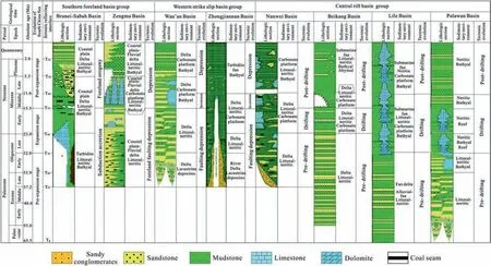
Fig.2 Differences in tectonic-sedimentary evolution of different basin groups in the Central-Southern South China Sea.
(2) Carbonate platform facies
This facies has widely developed since the Late Oligocene and lithologically is dominated by limestone accompanied by thin layers of mudstone and siltstone.The logging curve is box-shaped or bell-shaped.The seismic profile is mainly hillock shaped with medium frequency,medium continuity,and medium amplitude seismic facies (Fig.3).
(3) Shallow sea—bathyal facies
It is dominated by mudstone mixed with thick siltstone, and a thin layer of carbonate rock is occasionally seen.The logging curve is straight- and slightly-toothed,and seismic reflection characteristics are sub-parallel, medium frequency, medium-good continuity, and medium amplitude (Fig.3).
(4) Bathyal—deep sea facies
It is dominated by mudstone with a thin layer of siltstone.The logging curve is straight and slightly toothed.The seismic profile is characterized by subparallel-parallel, medium-low frequency, mediumgood continuity, and medium-strong amplitude reflection.Turbidite fan is developed locally, dominated by sandstone and mudstone interbedding.The seismic profile is lenticular with the internal continuity greatly changed(Fig.3).
4.1.2.Transitional sedimentary system
Delta facies and coastal plain facies were developed in the transitional sedimentary system.
(1) Delta facies
It is mainly composed of sandstone and is widely developed around basins and uplifts with a reverse rhythm in the vertical direction and funnel-shaped logging curves.Seismic reflections are dominated by foreset or chaotic foreset characteristics.The seismic profile along the source direction is a typical ‘S’shaped progradational reflection, while the seismic profile perpendicular to the source direction is a lenticular or lateral progradational reflection(Fig.3).
(2) Coastal plain facies
It is dominated by silt and argillaceous deposits,and the logging curve is slightly dentate.The seismic profile is characterized by parallel-sub-parallel,continuous, and high-amplitude reflections (Fig.3).
4.1.3.Terrestrial sedimentary system
Two types of sedimentary facies developed in terrestrial sedimentary system respectively as lacustrine facies and fluvial facies.
(1) Lacustrine facies
It is mainly developed in the early fault depression stage of the WBG with relatively limited distribution.The lithology is dominated by mudstone mixed with thin siltstone with low amplitude and zigzag shape on logging curves.The seismic profile is characterized by sub-parallel, medium-low frequency, medium continuity, and medium-strong amplitude reflections.
(2) Fluvial facies
It is mainly composed of interbedded sandstone and mudstone.The sandstone is mostly medium-to fine-grained with a thickness ranging from a few meters to tens of meters.It exhibits medium frequency, medium continuity, and medium amplitude reflections on seismic profiles with local downcutting characteristics.
4.2.The sedimentary filling structures of different types of basin groups
4.2.1.Southern foreland basin group
The southern basin group (SBG) is located on the southern continental margin of the SCS, in the northern part of Borneo.It is a compressional foreland basin group formed due to the subduction of the PSCS.The Cenozoic sedimentary evolution shows the transition from deep water to shallow water environments.This suggests that these basins were dominated by deepwater depositional systems formed before Early Oligocene with submarine fans developed.
Subsequently, the foreland basins were gradually dominated by shallow-water depositional systems with the development of deltas and shallow marine facies.The sedimentary formation assemblage on the northern side of Borneo records the specialsedimentary evolution process of ‘early deep water late shallow water’ in the SBG (Figs.4 and 5).The lower part of the basin group consists of oceanic crustal basement, and Cretaceous melange and diabase can be seen on the outcrop(Fig.5A and B),which has the characteristics of typical active continental margin sedimentary formation.The overlying Rajang Rocker Group is a set of deep-sea flysch deposits with typical Bouma Sequence and trough structures(Fig.5C and D) and is an accretionary wedge formed by the subduction of the PSCS.On top of the Rajang Rocker group, a molasse sedimentary sequence was developed (Fig.5E and F) representing an overall uplifting environment after the subduction, collision,and orogeny of the PSCS.After the Oligocene,with the continuous uplift of the orogenic belt, the northern Borneo was dominated by a shallow-water environment with shallow marine-delta facies (Fig.5G—I).

Table 1 Depositional characteristics of different basin groups in the CSSCS.

Table 2 Details of data used in this study.
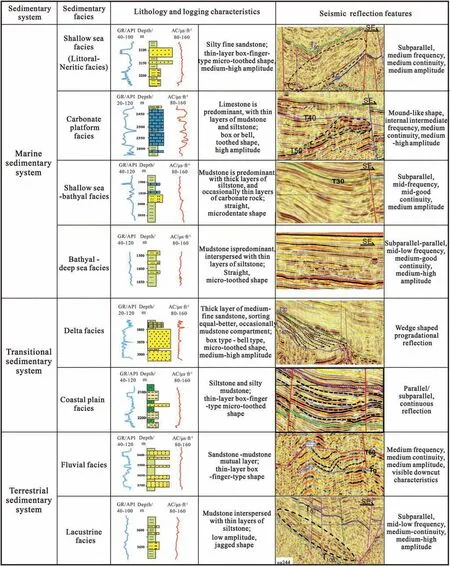
Fig.3 Comprehensive chart of sedimentary facies of the Central and Southern South China Sea.

Fig.4 Stratigraphic records of the southern basin group in northern Borneo(modified from van Hattum et al.,2006;Wang et al.,2016;Xie et al., 2023).
Specifically, controlled by the PSCS, the main part of the SBG was dominated by a deep-water environment during the Eocene with bathyal-deep-sea sedimentary facies developed (Fig.6A).During the Oligocene,owing to the collision between the Luconia and Borneo blocks caused by the subduction of the PSCS,a large scale delta began to develop in the west and south of Zengmu Basin.Simultaneously,the Brunei Sabah Basin inherited the early-period deep-water environment and began to develop submarine fan sedimentation within the basin because of the increased source supply resulting from the uplift of Borneo (Van Hattum et al., 2006; Cui et al., 2023)(Fig.6B and C).
The SBG generally entered into a shallow marine sedimentary environment in the Early Miocene.During this period,large deltas developed in the Zengmu Basin owing to the subduction of the PSCS.Simultaneously, the Meiligan Delta also began to develop in the Brunei—Sabah Basin (Fig.6D).During the Middle Miocene, due to the counter-clockwise rotation of Borneo, the provenance of the Zengmu Basin delta changed from southwest to the southeast(Guo et al.,2016), and the dextral strike-slip movement of the Baram fault caused large carbonate platforms and reefs to develop in the Nankang platform.On the other hand,with the southern compression and uplift,the source supply to the Brunei—Sabah Basin continued to increase, which continuously increased the size of the delta and led to the continuous progradation towards the sea (Fig.6E).A clear foreset reflection structure was observed on seismic profiles(Cullen, 2010), and a folded and thrust zone was developed in the deep-water area(Tang et al.,2018).During the Pliocene—Quaternary period, with the acceleration of the subsidence rate, a delta-shallow sea-bathyal depositional system was developed in the SBG.

Fig.5 Typical outcrops in the northern Borneo (see Fig.1 for outcrop location).A) Strongly fractured and sheared deposits, Cretaceous melange, Sarawak; B) Grayish black, dark green structure, Cretaceous diabase, Sarawak; C) Multi-period normally-graded bedding, Bouma sequence (Ta-Te), Eocene deep-water turbidite, Sarawak; D) Flute cast structure, Eocene deep-water turbidite, Sabah; E) Coarse sediment with poor sorting and rounding, Late Eocene-Oligocene molasse, Sabah; F) Poorly sorted conglomertate, Late Eocene-Oligocene molasse,Sabah; G) Ripple lamination, Late Oligocene-Early Miocene tidal flat, Sabah; H) Scour surface and parallel bedding, Late Oligocene-Early Miocene tidal flat, Sabah; I) Foreset structure, Middle Miocene delta, Sabah.
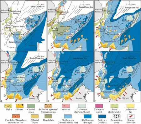
Fig.6 Cenozoic sedimentary evolution of Central-Southern South China Sea.A)During Late Eocene,the main part of the SBG was dominated by a deep-water environment,while the WBG was dominated by lacustrine deposits and the major of the CBG was marine environment,with clastic deposits developed;B)During Early Oligocene,large-scale delta and submarine fan began to develop in the SBG,while the WBG was dominated by(fan)delta-lacustrine depositional system,and the CBG inherited the early-period marine clastic sedimentary environment;C)During Late Oligocene, delta and submarine fan continually developed in the SBG, while the WBG entered into marine depositional environment,and the carbonate platform began to develop in the east part of CBG;D)During Early Miocene,large deltas continually developed in the Zengmu Basin,and delta began to develop within the Brunei-Sabah Basin,while the WBG was dominated by delta-shallow sea depositional systems,and the CBG was dominated by carbonate-shallow sea depositional systems, with the absence of deltas; E)During Middle Miocene,the provenance of the Zengmu Basin delta changed from southwest to southeast,and the size of the delta continuously increased in Brunei-Sabah Basin, while the scale of the delta in the WBG decreased, with carbonate platforms developed above the underwater highlands; the Beikang Basin of the CBG was uplifted and suffered erosion due to the collision between the Nansha and Luconia blocks, with deltas developed;F)During Late Miocene, the SCS entered into a stable subsidence stage,and the CSSCS inherited the early sedimentary pattern,with bathyal-deep sea facies largely developed.
4.2.2.Western strike-slip basin group
The western basin group (WBG) is located on the western continental margin of the SCS, and the overall sedimentary evolution is characterized by the‘transition from lake to marine environments’.The paleontological assemblage developed in the Wan'an Basin has recorded this sedimentary evolution process.A large number of lacustrine sapropelic and lowgrade aquatic paleontological assemblages were developed at the early stage.After the Oligocene,marine dinoflagellates and foraminifera were developed in large quantities (Fig.7).
During the Late Eocene, the WBG was dominated by lacustrine deposits, which were mainly distributed in the central and southern parts of the Wan'an Basin and the western part of the Zhongjiannan Basin(Fig.5A).In the Early Oligocene, the range of lacustrine deposits in the WBG further expanded (Fig.5B),except for the coastal and shallow sea deposits developed in the northern part of the Zhongjiannan Basin, due to marine transgression.During the late Oligocene,due to marine transgression,except for the west of Zhongjiannan Basin,most of the WBG entered into a marine sedimentary environment.Further,large-scale deltas were developed in the west of Wan'an Basin, mainly from the western uplift provenance (Wang et al., 2020).

Fig.7 A comprehensive histogram of the Cenozoic paleontology in Wan'an Basin, the western basin group.
In the Early Miocene,except for the alluvial facies developed at the junction of Wan'an Basin and Zhongjiannan Basin, the whole WBG entered into a marine depositional environment.The delta continued to develop in the western part of the Wan'an Basin,and carbonate platform deposits appeared in the northern and western parts of the Zhongjiannan Basin(Fig.5C).
In the Middle Miocene, tectonic uplift occurred in the region with the development of highlands due to strike-slip activities of the Yuedong fault(Zhang et al.,2019).At the same time, large-scale carbonate platforms began to develop with marine transgression,which continued until the end of the Late Miocene(Fig.6D and E).During this period,the delta continued to develop in the western part of the Wan'an Basin,and bathyal to deep-sea sedimentary facies began to develop in the Zhongjiannan Basin.
After the Late Miocene, the regional thermal subsidence intensified, and the whole region entered into the bathyal sedimentary environment (Zhao et al., 2016).However, in the west of the Wan'an Basin, the onshore source supply was sufficient, and the shelf margin delta-shallow water-continental slope depositional system was developed(Fig.6F).In the Zhongjiannan Basin, the submarine fan-bathyal sedimentary system was developed (Fig.6F).
4.2.3.Central rift basin group
The central basin group (CBG) was located on the northern continental margin of the PSCS before the Oligocene.Later, it split off from the South China continent and drifted southward due to the expansion of the SCS.At the end of the Middle Miocene, it collided with the Luconia and Borneo blocks and moved to the current position.Due to this distinct tectonic evolution process,the depositional evolution of rift basins illustrates the characteristics of ‘transition from clastic to carbonate environments’.This means that the rift basins were dominated by Eocene—Oligocene shallow marine clastic depositional systems, and carbonate platforms started to develop earlier in the east than in the west since Early Oligocene.Many exploration wells in the CBG have recorded this special depositional architecture.Taking well A in Beikang Basin as an example, the Oligocene strata were dominated by clastic delta, and the carbonate deposition started after the Early Miocene and dominated the strata after the Middle Miocene (Fig.8).
During the Eocene, the CBG was located in the northern part of the SCS, close to the South China continent.The paleontological fossils found in the Lile Basin were mainly dinoflagellates, calcareous ultramicro,and foraminifera(Wang et al.,2016),indicating that the basin was under a marine depositional environment during this period.Delta and shallow sea sedimentary systems were developed in the Lile Basin and Beikang Basin, with the provenance coming from the uplifts outside the basin.However, most of the Nanwei Basin was an uplift denudation area, and a small amount of lacustrine sedimentation developed locally (Xu et al., 2003) (Fig.6A).
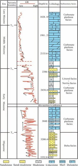
Fig.8 A comprehensive histogram of well A in Beikang Basin, the central basin group (see well location in Fig.1).
During the Early Oligocene, the CBG was close to the South China continent, and delta-coastal plainshallow sea sedimentary systems developed.The paleo uplifts and volcanoes provided source of sediments,and the scale of deltas was small.Lile and Palawan basins were mainly shallow sea deposits with shallow sea-bathyal deposits locally developed (Shao et al.,2017).The local uplift and erosion of northwest of Nansha Trough provided sources for the eastern part of the Beikang Basin, leading to the development of a delta-shallow sea sedimentary system in the Beikang Basin (Tang, 2018).At the same time, large-scale coastal plain facies was deposited in the Nanwei Basin (Fig.6B).
During the Late Oligocene—Miocene sedimentary period, due to the expansion of the SCS, the CBG was separated from the northern continental margin, and the provenance supply became insufficient during the drifting process.The main sedimentary facies was shallow sea facies.Large carbonate platforms continued to develop in the northern part of the Lile Basin (Wang et al., 2016).The Palawan Basin began to develop large-scale carbonate platforms since the Late Oligocene.In the Early Miocene, carbonate platforms were only developed in the northern part, and they were not developed after the Middle Miocene (Xie et al., 2023).The Nansha Trough Basin entered into a deep-water sedimentary environment after the Miocene.The Beikang Basin inherited characteristics of the early-period sedimentary environment in the late Oligocene, and the delta continued to develop.In the Early Miocene, the carbonate began to develop due to the expansion of the southwest sub-basin of SCS.In the Middle Miocene, the basin was uplifted and suffered erosion due to the collision between the Nansha and Luconia blocks, and deltas developed (Tang et al.,2021b).After the Late Miocene,the basin entered into a deep-water sedimentary environment(Fig.6C—E).
Since the Pliocene, with the rapid subsidence of the region, the CBG was dominated by bathyal sedimentation, while the northern part of the Lile Basin developed large-scale shallow-water carbonate platforms.The Nansha Trough Basin was dominated by bathyal to deep-sea deposits (Tang et al., 2018).The channel and submarine fan deposits dominated the Beikang Basin; however, the carbonate platforms continued to develop in the southern uplift margin.The Nanwei Basin was dominated by bathyal sedimentation with carbonate platforms continuing to develop above local paleo uplifts (Fig.6F).
5.Discussion
In the Cenozoic era,regional tectonic stress fields,i.e.extension, compression, and shear strike-slip stresses converged in the SCS.The geodynamic evolution caused by complex regional tectonics controlled the subduction and extinction of the PSCS and the multi-stage expansion of the SCS, which determined the formation and evolution of the SCS basins.Records of lithology of ophiolite and igneous rock,and strata in northern Borneo indicated that the PSCS was closed in a ‘scissors‘ manner from west to east (Soeria et al.,1999; Madon et al., 2013; Wang et al., 2016; Hall and Breitfild, 2017; Xie et al., 2023) with the main function during 45—15 Ma.However, the latest ocean drilling and magnetic anomaly strip analysis results showed that the SCS gradually expanded from east to west during the Oligocene to Early Miocene period (Li et al., 2015; Sibuet et al., 2016; Lin et al., 2019;Wang et al., 2019; Cao et al., 2020; Cui et al., 2021).Therefore,we believe that the scissor-style closure of the PSCS and the progressive-style expansion of the SCS jointly controlled differences in the sedimentary filling of the three basin groups in the CSSCS.Before the Late Eocene, the whole SCS region was under extensional stress due to the changes in the direction and rate of Pacific plate subduction (Fig.9A).In the later stage, the SBG was compressed under the joint action of the ‘scissors style’ closure of the PSCS and the ‘progressive’ expansion of the SCS (Fig.9B and C)due to the collision of blocks.The WBG underwent a strike-slip transformation due to the relative displacement between the blocks, and the CBG separated from the southern edge of the South China continent and drifted to its current position under continuous tension.Finally, three different basin groups, namely, the southern compressive foreland basin group, the western strike-slip basin group, and the central rift basin group were formed in the CSSCS with different sedimentary filling structures and different main controlling factors (Fig.9D).
5.1.The effects of PSCS subduction on SBG
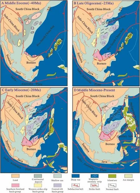
Fig.9 Schematic map of the Cenozoic tectonic evolution model for the South China Sea(modified from Sibuet et al.,2016;Hall and Breitfild,2017; Cao et al., 2020; Cui et al., 2021).A) Middle Eocene; B) Late Oligocene; C) Early Miocene; D) Middle-Miocene-present1-The Pearl River Mouth Basin; 2-Qiongdongnan Basin; 3-Zhongjiannan Basin; 4- Wan'an Basin; 5-Zengmu Basin; 6-Brunei Sabah Basin; 7-Palawan Basin; 8-Lile Basin; 9-Nansha Trough Basin; 10-Beikang Basin; 11-Nanwei Basin.
The Zengmu Basin and the Brunei—Sabah Basin of the SBG were typical compressive foreland basins,which were mainly developed on the Luconia block and the accretionary wedge of the Rajang Group formed by the subduction of the PSCS, respectively.Due to the scissor-style closure of the PSCS from west to east during the Eocene—Early Miocene, the time when the two basins entered foreland basin was generally‘early in the west and late in the east.’The Zengmu Basin experienced two tectonic evolution stages, namely, Eocene—Early Miocene foreland fault depression stage and Middle Miocene—Present depression stage (Liu et al., 2016).It is dominated by alternating development of carbonate platforms and deep depressions from Eocene to Miocene.The Brunei—Sabah basin experienced two tectonic evolution stages, namely, the subduction and accretion stage from Eocene to Early Miocene and the foreland orogenic stage from Middle Miocene to present, with the thick Miocene strata showing the characteristics of superimposed foreland(Tang et al.,2018).Accordingly, controlled by the subduction of the PSCS,the overall Cenozoic sedimentary evolution of the SBG showed the characteristic transition from deep water to shallow water environments.The stratigraphy of the Eocene—Oligocene was dominated by deep-water sediments with submarine fans(Fig.4).After Miocene, shallow water sedimentation was dominant, and delta, shallow marine facies, and carbonate platforms were developed.In addition,due to the scissor-style closure of the PSCS from west to east,the delta formation time of the SBG has the characteristics of ‘early in the west and late in the east’.Deltas developed in the Zengmu and Brunei—Sabah basins in Oligocene and Early Miocene, respectively.
5.2.The significance of paleo-uplifts and the SCS expansion on WBG
Unlike the SBG and CBG, the WBG was not only related to the expansion of the SCS but also to the collision dynamic system between the Indian Plate and the Eurasian Plate owing to the unique tectonic location (An et al., 2012).The Yuedong—Wan'an Fault is a large-scale strike-slip fault formed in the western part of the Zhongjiannan Basin and the eastern part of the Wan'an Basin under multiple stresses and multi-stage block slip effects (Fyhn et al., 2009).In the Cenozoic, due to the SCS expansion and the Yuedong—Wan'an fault activity, the WBG experienced three evolution stages: the fault depression stage(Late Eocene—Early Miocene), the strike-slip transformation stage (Middle Miocene),and the depression stage (since the late Miocene) (Zhao et al., 2016).At the early stage of the fault depression,before the SCS expansion, the basin sedimentation was controlled by paleo uplifts.The large-scale paleo uplift occurred between the Zhongjiannan and Wan'an basins, separating the continental and marine sediments and controlling the distribution range of Eocene lacustrine sediments.After the Late Oligocene, with the expansion of the SCS, seawater inundated the basin from northeast,and the WBG gradually entered into marine sedimentary environment with the overall filling characteristics of ‘transition from lake to marine environments.When the expansion of the SCS ceased,the WBG was mainly affected by the strike-slip motion of the Yuedong—Wan'an Fault.The central part of the Zhongjiannan Basin and the southern part of the Wan'an Basin experienced strong strike-slip pull-apart subsidence, which controlled the depositional centre of the basin.Simultaneously, the tension and torsion derived from the strike-slip caused local inversion of the basin, forming an anticline and providing conditions for the development of carbonate platforms(Zhao et al., 2016).After the Late Miocene, the WBG as a whole was at a relatively stable subsidence stage,entering into a deep-water sedimentary environment except for the western shelf edge.Therefore, the paleo uplift and the expansion of the SCS jointly controlled the sedimentary pattern of WBG.
5.3.The implication of the SCS expansion on CBG
Considering the expansion of the SCS as a node,the CBG experienced three stages of tectonic evolution during the Cenozoic era: pre-drifting, drifting,and post-drifting (Fig.2).During the pre-drifting stage, the CBG was located on the northern continental margin of the PSCS (Taylor B and Hayse, 1983;Briais et al.,1993;Shao et al.,2017;Xie et al.,2023),and a series of graben and half-graben structures dominated by clastic rock deposits were formed due to extensional stress.However,only small-scale deltas were developed as it was located far away from the South China continent and was mainly supplied by peripheral small uplifts (Fig.6).During the drifting period from Oligocene to Early Miocene, Palawan,Lile,Nanwei,and Beikang basins were separated from the South China continent in turn and drifted southward.A clear water environment, which was conducive to the development of carbonate platforms,formed due to the lack of supply of terrigenous clastic sediments.At the same time, due to the ‘gradual’expansion of the SCS from east to west, carbonate platform of the CBG also showed the characteristics of‘developing in the east in early period and in the west in late period.’The Palawan and Beikang basins began to develop carbonate platforms during the Oligocene and Early Miocene, respectively (Shao et al., 2017;Tang et al., 2018).In the Middle Miocene, with the collision of the Nansha and Borneo blocks, the SCS expansion ended, and the CBG began to subside as a whole (Li et al., 2015; Xie et al., 2023).During this period, the CBG was dominated by deep-water deposits, except for the continued development of carbonate platforms above local uplifts.Therefore, the expansion of the SCS led to the detachment of the CBG from the South China continent, controlling the sedimentary filling evolution of the CBG, and ultimately forming a sedimentary filling pattern of“shifting from underlying clastic deposits to overlying carbonate deposits”.
6.Conclusions
1) In the CSSCS,there are three types of sedimentary basins: foreland, strike-slip, and rift type, with three different sedimentary filling structures.The southern foreland basin group exhibited a depositional pattern of ‘transition from deep water to shallow water environments'.During the Eocene,the basin group was dominated by deep-water sedimentation, and it was dominated by shallowwater sedimentation after the Oligocene with the development of deltas and shallow marine facies.The strike-slip basin group in the west showed a sedimentary pattern of ‘transition from lake to marine environments’.In the Eocene, lacustrine deposits were dominant,and Oligocene to Miocene period was dominated by marine deposits with the development of delta, shallow sea, and deep sea deposits.The central rifting basin group was mainly composed of Eocene—Oligocene marine sediments and has the characteristics of ‘transition from clastic to carbonate environments’.
2) The differences in sedimentary filling structures between the three basin groups in the CSSCS are closely related to the scissor-style closure of the PSCS and the progressive-style expansion of the SCS.The subduction of the PSCS mainly controlled the sedimentary pattern of ‘transition from deep water to shallow water environments’ of the SBG.The block drifting caused by the expansion of the SCS mainly controlled the‘transition from clastic to carbonate environments’ of the CBG, while the paleo-uplifts and the expansion of the SCS jointly controlled the sedimentary pattern of the ‘transition from lake to marine environments’in the WBG.D
eclaration of competing interest
The authors declare that they have no known competing financial interests or personal relationships that could have appeared to influence the work reported in this paper.
Acknowledgements
This work is granted by the National Science and Technology Major Project (No.2016ZX05026-004),National Natural Science Foundation of China (No.91528303) and CNOOC basic geology and exploration strategy of natural gas projects in the South China Sea(2021-KT-YXKY-05, YXKY-ZX-02-2021).We would like to thank China National Offshore Oil Corporation(CNOOC)for permission to publish this work.We thank Professor Hai-Teng Zhuo from Sun Yat-sen University for his help on English edition.Constructive reviews by two referees and editorial handling by Yuan Wang and Santanu Banerjee are gratefully appreciated.
杂志排行
Journal of Palaeogeography的其它文章
- Power-law patterns in the Phanerozoic sedimentary records of carbon, oxygen, sulfur,and strontium isotopes
- The reservoir characteristics and their controlling factors of the sublacustrine fan in the Paleogene Dongying Formation, Bohai Sea,China
- A synthesis of the Cretaceous wildfire record related to atmospheric oxygen levels?
- Trace fossil evidences of an Early Miocene paleoseismic event and depositional regime change from the Kutch (Kachchh) Basin
- Interpreting siliciclastic sedimentation in the upper Paleozoic Mulargia-Escalaplano Basin(Sardinia, Italy): influence of tectonics on provenance
- Stratigraphy of the Alveolina elliptica group from the Middle Eocene of Iran: Calibration with calcareous nannofossils biozones and description of Alveolina ozcani n.sp.
