Trace fossil evidences of an Early Miocene paleoseismic event and depositional regime change from the Kutch (Kachchh) Basin
2024-01-25AyushSrivastavaSudiptaDasguptaKrishanuChatterjeeMohuliDas
Ayush Srivastava, Sudipta Dasgupta, Krishanu Chatterjee,Mohuli Das
Bombay Ichnos Research Group, Department of Earth Sciences, Indian Institute of Technology Bombay (IIT Bombay), Powai, Mumbai, Maharashtra 400076, India
Abstract Unconsolidated siliciclastic sediments can undergo post-burial deformation, which leads to the formation of distinctive sedimentary structures, known as soft-sediment deformation structures (SSDS).The presence of a series of sand volcanoes confined to a particular lithostratigraphic horizon can represent a paleoseismic activity and, thereby, exemplifies the concept of “seismite”.The Kutch Basin has been a tectonically active region since the initiation of eastern Gondwana rifting followed by a tectonic inversion during the Cenozoic due to the collision of the Indian and Eurasian plates.A stratum-bound series of sand volcanoes belonging to the Khari Nadi Formation(KNF)is exposed along the banks of Khari River.They separate the shallow marine deposits below and non-marine deposits above with their characteristic marine and paleosol trace fossil suites, respectively.Although a seismogenic origin has been much debated for the SSDS,the ichnofabric analysis of the sand-volcano-bearing stratum unequivocally points toward such an origin under a shallow seafloor condition.In addition to the sedimentary regime change from an open shallow-marine setting to a continental depositional environment concomitant with basinal uplift, the behavior of the burrowing crustaceans testifies to a syn-depositional development of a fault network associated with the fluidization, sand volcanism, and the resilience of the trace-producers in surviving those processes until the sedimentary regime change in the overlying strata.Although the ichno-sedimentological evidence apparently differs from the previous works that proposed a continuous base-level rise from the beginning of deposition of the Khari Nadi Formation up to the middle part of the overlying Chhasra Formation,the paleoseismic activity,its ichnologic signature, and the depositional regime change refer to a higher-resolution (i.e., lower-order)sequence-stratigraphic change causing a short-duration regression within a longer-duration cycle of baselevel rise.
Keywords Sand volcano, Seismite, Ichnology, Khari Nadi Formation, Kutch Basin, Kachchh Basin
1.Introduction
Sediments are susceptible to deformation before undergoing lithification and diagenesis (e.g., Owen et al., 2011) and such deformational structures are known as soft-sediment deformation structures(SSDS).SSDS are caused by different triggers and can develop in several media associated with various depositional settings, such as glacial, deltaic, estuarine,shallow marine,deep marine,fluvial,lacustrine,etc.(Seilacher, 1969; Pratt, 1994; Rossetti, 1999;Rodríguez-Pascua et al,2000;Obermeier et al.,2005;van Loon, 2009; Moretti et al., 2016; T¨or″o and Pratt,2016; Shanmugam, 2017a, 2017b).A wide range of trigger mechanisms has been identified causing the generation of the SSDS, e.g., overloading, storm waves, sudden fluctuations in the groundwater table,karst activity, tsunamis, and tidal activity (Guhman and Pederson, 1992; Holzer and Clark, 1993; Molina et al., 1998; Moretti et al., 2001, 2011; Alfaro et al,2002; Mazumder et al, 2006; Greb and Archer, 2007;Sarkar et al., 2014).Seismic liquefaction generally occurs by the action of earthquakes having a magnitude of >5 (Ambraseys et al, 1988) and extends up to 40 km from the epicentre (more than 90 % of recent seismic events) (Galli, 2000).The term “seismite”,first coined by Seilacher(1969),is used to identify the different types of SSDS formed by seismic origin.The morphology of the seismite depends on the magnitude of the paleoearthquake (Guiraud and Plaziat, 1993;Rodríguez-Pascua et al., 2000), which is instrumental to trace the active fault regions (Alfaro et al., 2010).Seismites have been reported in sediments ranging from Paleoproterozoic and Meso-Neoproterozoic to the Recent(Pratt,1994;Owen,1995;Mazumder et al.,2006; van Loon and Su, 2013; Sarkar et al., 2014;Bhattacharya et al., 2016; Feng et al, 2016; Roy and Banerjee, 2016; Feng, 2017; Bhattacharya and Saha,2020).The SSDS formed by liquefaction can have a wide variety of architecture depending on the depositional setting and duration of the deformation,while the trigger mechanism plays a minute role (Owen et al., 2011).Therefore, SSDS have been suggested to attain similar morphological affinities independent of their producing trigger mechanism(s), i.e., seismic shock or some other trigger mechanisms (van Loon,2009).However, structures such as sand dikes and sand blows/sand volcanoes are distinctive characteristics of earthquake-induced liquefaction (Obermeier,1996).
Ichnology is the study of trails, tracks, burrows,and borings, which broadly involves the study of bioturbation and sediment reworking by multicellular(or tissue-bearing) organisms.Ichnology encompasses the study of processes and the products of their ethological significance.The processes comprise organismsubstrate interactions and the products are the traces (trace fossils from the geological past) themselves (e.g., Bromley, 1996; Seilacher, 2007; Buatois and M′angano, 2011; Knaust, 2017).Since its inception, ichnology has evolved as an important tool in unravelling the paleoenvironment and depositional history of a sedimentary basin (e.g., Knaust and Bromley, 2012; M′angano and Buatois, 2016a, 2016b;Sedorko and Francischini, 2021).Ichnologic investigation can aid in identifying the allo- and autostratigraphically significant surfaces and the sealevel dynamics of a sedimentary basin (Savrda, 1991,1995;Pemberton et al.,1992;Krawinkel and Seyfried,1996; Dasgupta and Buatois, 2012, 2015; Dasgupta et al., 2016a, 2016b).Trace fossils have also established themselves as a valuable means for hydrocarbon exploration and production (e.g., Pemberton, 1992;Pemberton and Gingras, 2005; Tonkin et al., 2010;Gingras et al., 2012; Hsieh et al, 2015).
The present study offers insight into the ichnological evidence of sedimentary horizons deposited during paleoseismic activity in the Early Miocene of the Kutch (Kachchh) Basin of Gujarat State, India.A stratum containing a series of sand volcanoes exposed within the Khari Nadi Formation of the Aida region also records a unique behavior of trace-makers in response to the paleoseismic activity.An integrated approach using “seismite”-type deposits and their corresponding ichnological evidence has not been reported in the literature.However, seminal works,reviews, and criticism of the seismite concept and SSDS are numerous (Seilacher, 1969; Pratt, 1994;Rossetti, 1999; Rodríguez-Pascua et al., 2000;Obermeier et al.,2005;van Loon,2009;He and Qiao,2015;Feng et al.,2016;Moretti et al.,2016;T¨or″o and Pratt,2016;Feng,2017;Shanmugam,2017a,2017b).The characterization and classification of“seismites”have been also debated (Shanmugam, 2016, 2017a,2017b).This study utilizes a different ichnological approach of documenting the relationship between the animal-substrate interactive behavior and SSDS in the context of both the sedimentological regime change and the resultant high-resolution (low-order)sequence-stratigraphic change within the Early Miocene succession of the Kutch Basin.
2.Geological background
The Kutch Basin initially developed as a pericratonic aulacogen at the westernmost margin of India(Biswas, 1992, 2005).The east—west-oriented fossil rift is surrounded by the Nagar Parker ridge in the north, the Kathiawar uplift in the south, and the Radhanpur—Barmer arch in the east (Biswas, 1982).The western margin of the basin is open and gradationally merges with the continental shelf as a passive margin.The formation of the Kutch Basin dates back to the Late Triassic—Early Jurassic, when rifting was initiated by reactivation of the pre-existing Precambrian fault system during the Gondwanaland breakup(from Africa in the case of Kutch Basin).Subsequent tectonic inversion was caused by the collision of Indian and Eurasian plates from the Paleocene—Eocene time onwards.After the “hard” collision, the Mio-Pliocene duration demarcates a relatively sluggish northward movement of the Indian plate but with higher sediment accumulation (Biswas, 1982, 1992).Thus, the normal faults, characterized by half grabens activated during the extensional phase turned into compressional as well as strike-slip faults during compressional tectonics (Biswas, 2005; Shaikh et al,2020).During the Cenozoic Era, sedimentation ensued as a mixed siliciclastic-carbonate system and punctuated by several basin-wide unconformities(Fig.1).
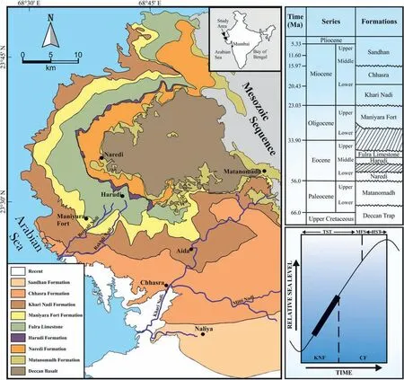
Fig.1 Geological map and Cenozoic stratigraphic succession of the Kutch Basin along with a representative base-level curve for the western Kutch Basin during the Early Miocene(modified after Biswas,1992;Kumar et al,2009;Saraswati et al,2018).KNF:Khari Nadi Formation;CF:Chhasra Formation; HST: Highstand systems tract; MFS: Maximum flooding surface; TST: Transgressive systems tract.
Out of the 900 m Cenozoic megasequence, the Neogene interval of the onland western Kutch Basin consists of almost 800 m,thereby indicating a high rate and amount of sediment accumulation during the Neogene with simultaneous progressive burial of the Paleogene sediments (Biswas, 1992; Dutta et al.,2020).Extensive transgression during the Early Miocene resulted in accommodation creation filled by the deposits of the Khari Nadi Formation(KNF)and the Chhasra Formation (CF).Biostratigraphic studies suggest Aquitanian and Burdigalian ages for the KNF and the CF,respectively(Biswas,1992;Kumar et al.,2009,2016; Kundal and Kundal, 2010; Mandal, 2010; Verma et al.,2013;Kundal, 2014).
The present study area, i.e., Aida Cliff sections along the Khari River, represents the lower part of KNF.The gross lithology of the KNF is defined by silty to very fine-grained sandstones, which show a mottled appearance due to bioturbation with intermittent layers of blue, grey, and brown mudstones(Biswas,1992;Kumar et al.,2016).Paleobathymetric analysis of fossils revealed that the KNF had been deposited during a 3rd-order transgressive cycle(Kumar et al., 2009, 2016).The maximum flooding surface (MFS) has been marked within the overlying CF by the sudden occurrence of a planktic foraminiferal assemblage above the dominant assemblage of benthic foraminifera(Fig.1;compare.figures 6—7 in Kumar et al., 2009 and table 2 in Kumar et al.,2016).
3.Methodology
Detailed field investigation was carried out in March 2022 along the Khari River in and around Aida(Fig.1).The outcrop was measured and described considering the lithology, grain size, physical and biogenic sedimentary structures, ichnofabric parameters, e.g., ichnodiversity, trace fossil abundance expressed by the bioturbation index (BI; sensu Taylor and Goldring, 1993), and discontinuity surfaces.The ichnofacies for each lithofacies association was identified.The bed containing the sand volcanoes as well as the underlying and overlying bed sets were photographed and analyzed in detail for their sedimentary structures and trace fossil characteristics.The photographs were scrutinized in further detail to investigate(1)the relationship among the trace fossils in each layer in order to construct ichnofabric (primarily tiering) diagrams and the ichno-taphonomic pathway for the lower part of KNF (compare chapter 5 in Buatois and M′angano (2011) and chapter 5 in Knaust and Bromley (2012)); (2) the characterization of the SSDS along the sand-volcano-bearing beds;and,(3) the cross-cutting and overprinting relationship between the SSDS(both fluidization-related structures and faults) and the trace fossils.
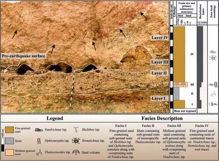
Fig.2 Field photograph and lithology of the studied Aida cliff section,Kutch Basin(note the length of staff is 1.5 m).The four layers(Layer I to Layer IV)along with their lithological boundaries(white dashed lines)are shown here.The lithological variations of the section along with the trace fossil assemblages and facies description are also shown in this figure.The stratum-bound sand volcanoes can be seen in the section field photograph along the Layer III.The boundary between Layer II and Layer III marks the pre-earthquake surface, i.e., the surface which was exposed during the seismic event and the sand volcano formed above this surface within the Layer III.The pedogenized Layer IV contains a channel cut-and-fill structure(black arrows).f/m/c/mU/mL:Fine/medium/coarse/medium upper/medium lower in Canstrat's Sand Grain Size Comparator™.
4.Results
4.1.Lithological and ichnological characteristics
4.1.1.Lithology
The studied section consists of four different semiconsolidated, grossly subhorizontal, and homoclinal beds.They are designated in this study as Layer I toLayer IV,from bottom to top(Fig.2).All the beds are barren of macro-invertebrate fossils.The base of the section is not exposed and the top has been eroded away.Therefore, only approximate thicknesses of layers I and IV are shown here.
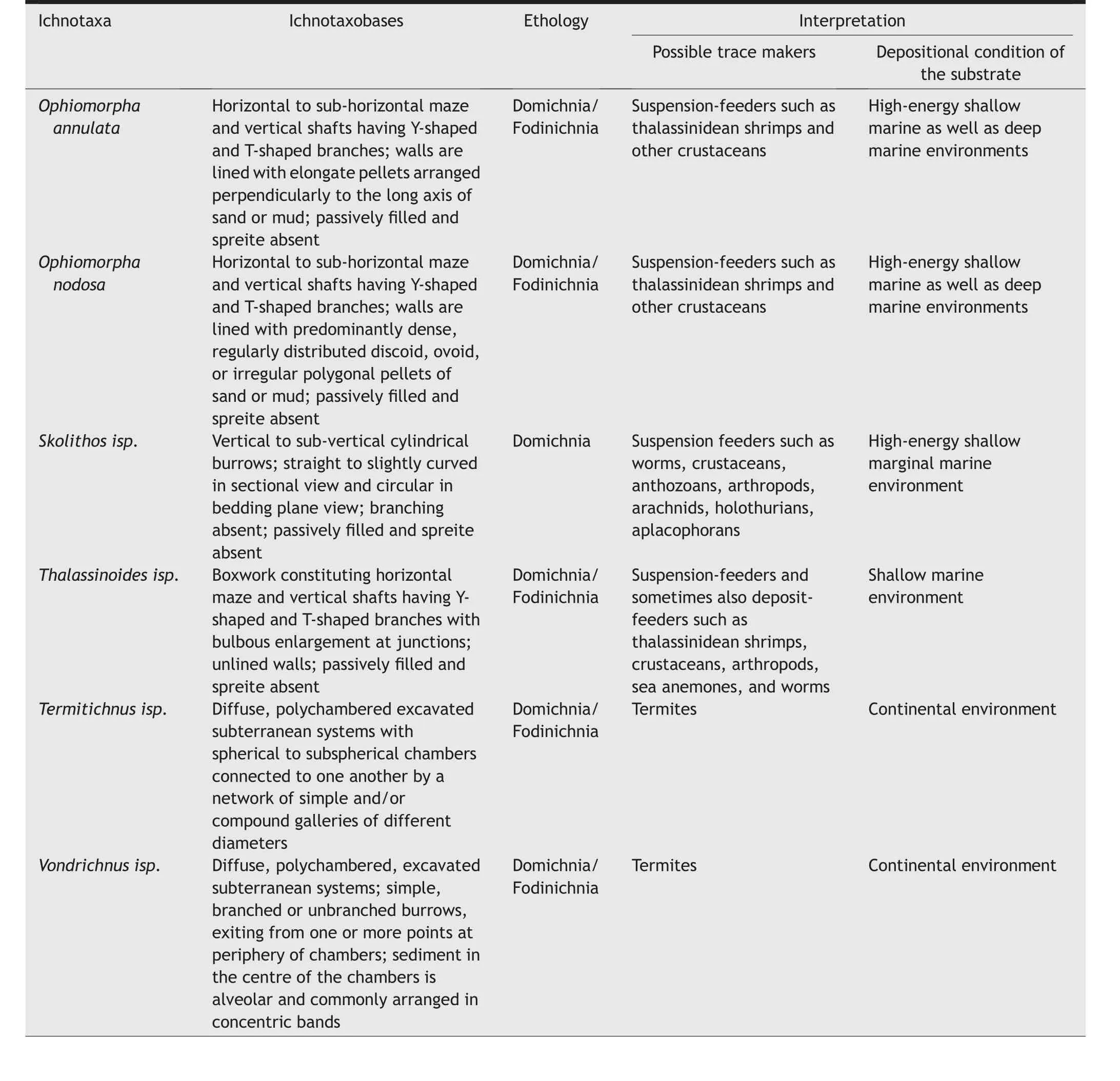
Table 1 Ichnotaxa,ichnotaxobases,ethology,possible trace makers,and depositional conditions of the substrate of the Aida cliff section,Khari Nadi, Kutch Basin.
Layer I is composed of fine-grained, moderately bioturbated sand with an exposed thickness of~60 cm with no visible primary sedimentary structure.
Layer II is composed of planar-laminated, lowbioturbated shales to silty shales with an average thickness of ~85 cm.
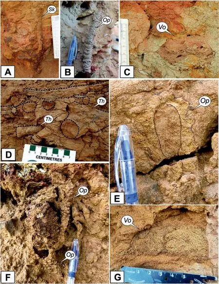
Fig.3 Ichnocoenoses of Layer I,II,and III from the studied Aida cliff section,Kutch Basin(note that the length of scale in A and C is 10 cm;the length of pen cap in B,E,and F is 5.5 cm;and the length of scale in D and G is 7 cm).The fine-grained sand layer(Layer I)and shale layer(layer II) contain marine trace fossil assemblages.The medium-grained sand layer (Layer III) contains both marine as well as continental assemblages.A) Sectional view of Skolithos isp.from Layer I showing typical vertical to sub-vertical cylindrical, straight orientation; B)Ophiomorpha annulata from Layer I having typical elongated pellets lining the wall; C) Chamber of the termite nest Vondrichnus isp.from Layer IV;D)Thalassinoides isp.from Layer II with cylindrical burrow cross-section forming a boxwork network with Y-and T-shaped branching;E) Cross-section view of Ophiomorpha nodosa from Layer III, burrow wall lined with nodular pellets; F) Boxwork branching structure of Ophiomorpha nodosa from Layer III; G) Chamber of termite nests i.e., Vondrichnus isp.within the sand volcano.Op: Ophiomorpha isp.; Sk:Skolithos isp.; Th: Thalassinoides isp.; Vo: Vondrichnus isp.
Layer III is a sorted, medium-grained, moderately bioturbated sand containing a series of conical moundlike convex-up structures(i.e.,the sand volcanoes;see Section 4.2 for further details).The bed shows a feeble normal grading(from medium upper to medium lower,i.e.mU to mL, in Canstrat™Sand Grain Size Comparator; refer to https://canstrat.com/products/grainsize-cards.html).The average thickness of this bed varies between 20 cm(i.e.,away from the sand volcano positions)and 45 cm(i.e.,from base to the crest of the sand volcanoes).The sand layer is laminated, where not liquefied, and attains a massive appearance,wherever it shows an intrusive cross-cutting character(i.e.,along the conduits of sand volcanoes).Laminae at the crest of the mound-like structures are relatively prominent and show synsedimentary faults.The sand in and around each sand volcano is well-sorted making it“clean” and loose enough to be eroded away, and creating small caverns along the bed (Figs.2 and 5).Only the central conduits are intermittently preserved.Approximately only 25 % of the sand volcanoes fully escaped recent surface erosion.
Layer IV is composed of silty fine-grained, highlybioturbated sand with a thickness of ca.3.5 m and is devoid of any visible sedimentary structures other than channel cut-and-fill, pedogenic features throughout (more intense within the channel fill;Fig.2), and trace fossils (Fig.4A).
4.1.2.Trace fossil characteristics
Table 1 lists all the ichnotaxa that are present in the studied section, their diagnostic ichnotaxobases,and ethological and depositional inferences.
The ichno-assemblage of Layer I consists of a softground suite of Skolithos isp.(Fig.3A).and Ophiomorpha annulata(Fig.3B),along with an overprinting suite of termite nesting chambers Vondrichnus isp.from overlying layers(Fig.3C).
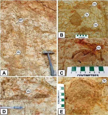
Fig.4 Ichnocoenoses of the continental Layer IV from the studied Aida cliff section, Kutch Basin (note that the length of hammer in A is 33 cm; the length of scale in B, C, and E is 7 cm; and the length of pen cap in D is 5.5 cm).A) Intense bioturbation showing cross-cutting relationship between different generation of isopteran burrows with well-formed termite chambers along with root traces; B) Association of Vondrichnus isp.and Termitichnus isp.; C) Chamber of Vondrichnus isp.showing concentric layering; D) Chambers of Vondrichnus isp.connected by horizontal tunnels; E) Spherical chamber of Termitichnus isp.with varying tunnel diameter.Vo: Vondrichnus isp.; Te: Termmitichus isp.; RT: Root traces.
Layer II shows a softground monospecific suite of Thalassinoides shafts, chambers and galleries(Fig.3D).Shafts of Termitichnus isp.from overlying layers crosscut the softground suite, but do not open into chambers in this layer.
Layer III contains a softground monospecific suite of Ophiomorpha nodosa(Fig.3E and F),overprinted by shafts and chambers of termite nests (Vondrichnus isp.) coming from Layer IV (Fig.3G).
The ichnocoenoses of the topmost Layer IV consist of termite tunnels, galleries and chambers (Vondrichnus isp.and Termitichnus isp.) along with root traces(Fig.4).The colonization surface of the termite nests is exposed away from the study area and is stratigraphically overlain by a bioclastic rudstone(marine) with a sharp basal contact, which is beyond the scope of this study.
Fig.5 illustrates how the four layers collectively demonstrate the complex ichnofabric in terms of trace fossil abundances, ichnodiversity, and tiering.The organisms affected and disrupted the original fabric of the sediments by bioturbation.The resultant fabric and texture of the sediment can be understood by using the ichnofabric concept, which helps in understanding and visualizing the tiering and density of the various ichnotaxa (Bromley and Ekdale, 1986).The concept of taphonomic pathways has been adapted for ichnology to understand the interrelation between the depositional and ichnotaphonomic processes (Buatois and M′angano,2004, 2007).The ichnotaphonomic processes within the studied section are shown in Fig.6 that reflects the chronological succession of bioturbation events and their overprinting.
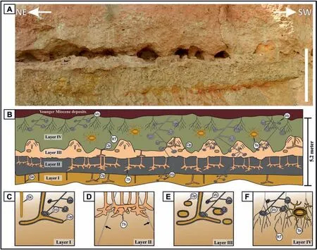
Fig.5 Ichnofabrics of the studied Aida cliff section,Kutch Basin(note that the length of white bar is 1.5 m).A)Stitched section photograph;B)Sketch of the complete section showing multiple generations of trace fossils of marine(Skolithos isp.,Ophiomorpha nodosa,Ophiomorpha annulata,Thlassinoides isp.)to continental(Vondrichnus isp.,Termitichnus isp.,and root traces)origin;C—F)The trace fossil assemblages of the four layers I—IV are shown in their respective ichnofabric diagrams.The shallow marine traces(Skolithos isp.and Ophiomorpha annulata)within Layer I have been overprinted by deep tiering continental termite chambers(Vondrichnus isp.)originating from the Layer IV.Layer II contains Thalassinoides isp.overprinted by tunnels of termite nests (shown with black arrows in D).Layer III contains Ophiomorpha nodosa along with Vondrichnus isp.,and the former being overlapped by the latter.Layer IV consists of complete continental traces,i.e.,Vondrichnus isp., Termitichnus isp., and root traces.Sk: Skolithos isp.; Op: Ophiomorpha isp.; Th: Thalassinoides isp.; Vo: Vondrichnus isp.; Te: Termitichnus isp.; RT: Root traces.
4.2.Sand volcano
A series of approximately conical-shaped sand volcanoes with their associated array of faults are observed along Layer III (Figs.2 and 7).The following observations on the sand volcanoes have been made by closely observing and correlating the sedimentological, deformational, and the ichnological attributes.
1) The dimension and spacing of each sand volcano cone are: Length: 80 cm—120 cm; height:50 cm—70 cm;lateral distance between two axes of consecutive cones:150 cm—310 cm.
2) There are steep(70°—90°)faults around each main sand volcano conduit (Fig.7).The faults show normal movement that can be interpreted to be due to the gravitational collapse of the conical sand mass, both away from the conduit and toward it forming a mesoscopic-scale caldera-like structure.
3) Three generations of trace fossil colonization (two generations of Ophiomorpha nodosa and a termite nest development) can be identified within the sand volcanoes.The sequential identification of generations is on the basis of the cross-cutting relationship between the synsedimentary faults and the trace fossils as shown in Figs.7 and 8.The first generation of Ophiomorpha nodosa predates the fault and, therefore, shows disruption by faulting (Figs.7, 8A—B).The second generation of Ophiomorpha nodosa burrows formed after the event involving liquefaction, sand volcanism, and associated faulting because these burrows cut across the faults (Figs.7 and 8D).The third generation of bioturbation consists of the intricate threedimensional network of termite nests consisting of chambers, tunnels, and shafts (see Section 4.1.2).They originate from Layer IV and overprint the laminations,faults and two previous generations of Ophiomorpha nodosa burrows(Fig.8C and D).
5.Discussion
5.1.Ichnofacies interpretation and implications
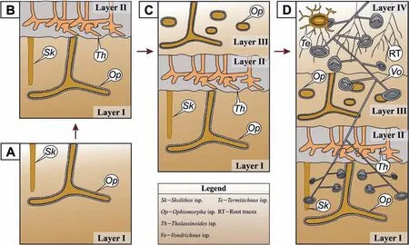
Fig.6 Ichnotaphonomic pathways involved in the preservation of the trace fossil assemblages of the studied Aida cliff section,Kutch Basin shown in chronological order starting with the deposition and bioturbation of Layer I up to of Layer IV.A)Shallow to middle tier Skolithos isp.and Ophiomorpha annulata in Layer I (Skolithos ichnofacies); B) Deposition followed by colonization of Layer II forming a shallow to middle tier Thalassinoides isp; C) Deposition of Layer III, which later was colonized by crustaceans forming softground Ophiomorpha nodosa (Skolithos ichnofacies);D)Deposition of fine-grained sand Layer IV took place within the continental regime.Termites formed deep tier chambers,tunnels and shafts of Vondrichnus isp.and Termitichnus isp.(Termitichnus ichnofacies), which reached down to Layer I.This layer also contains rhizoturbation (root traces).
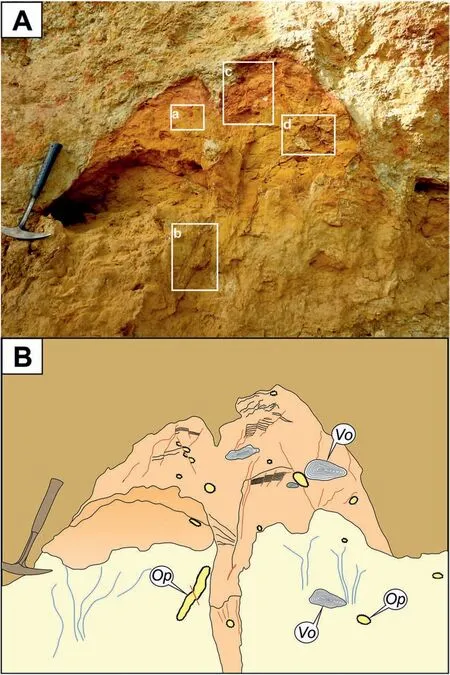
Fig.7 A) Photograph of sand volcanoes from the studied Aida cliff section, Kutch Basin (note the hammer length is 28 cm).The numbered boxes show the position of close-up photographs taken(see Fig.8);B)Sketch of the sand volcano showing all mesoscopic features,i.e.,the vent,flanks,laminations,syn-sedimentary faults,and water escape structures(marked in blue color).The bioturbation(Ophiomorpha nodosa and Vondrichnus isp.)and the mesoscopic faults(marked in red color),and their cross-cutting relationships are also shown.Op:Ophiomorpha isp.(Ophiomorpha nodosa); Vo: Vondrichnus isp.
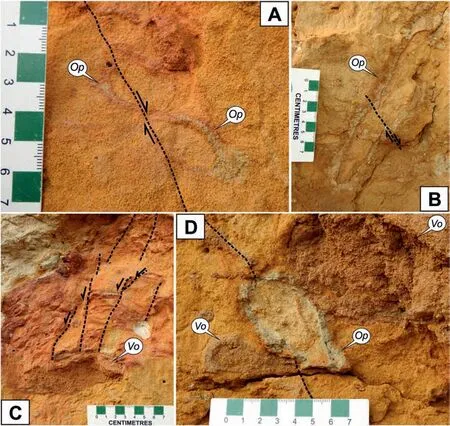
Fig.8 Close-up photographs(A,B,C,D are the close-ups of boxes a,b,c,d of Fig.7 respectively)of some typical features within the sand volcano from the studied Aida cliff section,Kutch Basin.A)and B)Cross-sections of Ophiomorpha nodosa disrupted by fault(shown with black dashed line); note that the slip of the fault is shown using pairs of half arrows; C) Laminations within the sand volcano, deformed and displaced by a series of faults(shown with black dashed lines).These faults terminate at the boundary of Vondrichnus isp.which shows that Vondrichnus isp.postdates the formation of the lamination as well as the deformation;D)Ophiomorpha nodosa overprinting the fault(shown with black dashed line).Also, the Vondrichnus isp.chamber overlaps the pelleted wall of Ophiomorpha nodosa.Op: Ophiomorpha isp.(Ophiomorpha nodosa); Vo: Vondrichnus isp.
The development of sand volcanoes and faults within them and the significance of the trace fossils for interpreting the structures produced by softsediment deformations can be untangled and understood by integrating sedimentological and ichnological observations.The softground trace fossils of the Layer I and Layer III are characteristic of the Skolithos ichnofacies(Figs.5 and 6),whereas Layer II only contains softground Thalassinoides with other shallow-tier ichnofossils being obscured by this middle-tier network.The dominance of suspensionfeeding behavior and domichnia of marine crustaceans(with predominant vertical orientation;Fig.3A,B,F)indicates a shallow-marine(upper shoreface)or perhaps a marginal-marine (wave-dominated shoaling) depositional setting for the layers I, II, and III.Devoid of any trace fossil of marine affinity, the pedogenized Layer IV only records highly abundant(BI = 4) termite nests and rhizoturbation.With the relic of a channel cut-and-fill structure, Layer IV can be interpreted to have been deposited in a continental (floodplain) or semi-continental (delta plain)depositional environment.The top contact of the sand-volcano-bearing Layer III marks a turnover from marine to continental settings.
Liquefaction at a very shallow seafloor, as evidenced continuously along a bed, implies its seismic origin.The crustacean producers continued their burrowing activity by utilizing the sand extrusion event well, as the liquefaction supplied loose sand for pelleted lining of the burrow wall, producing Ophiomorpha nodosa.Hence, two generations of Ophiomorpha nodosa can be observed.The sand volcano and its host bed were buried by ensued sedimentation under the marginal-marine to continental transitional settings for a short amount of time.
Furthermore, there is no visible erosional contact at the top of Layer III.Rather, the top of the sand volcanoes has been well preserved (Fig.7).Later,deposition of the topmost Layer IV took place under a wet continental setting as suggested by the Termitichnus ichnofacies developed in it and penetrating the layers I—III as well.The Termitichnus ichnofacies develops in closed forests with a very shallow water-table resulting in a gleyey soil (or paleosol) (Mueller-Dombois and Ellenberg, 1980;Genise et al., 2000, 2004, 2010).This observation corroborates a tropical forested wet floodplain or subaqueous delta plain setting.The pedogenesis likely enabled the preservation of the intricate paleogeomorphic features, i.e., the sand volcanoes,because the deeper paleosol horizon below the water table did not go through much pedogenic alteration of the mesoscopic fabric.Deeper penetration of the Termitichnus ichnofacies into layers I—III must have been due to seasonal fluctuations of the water table.
5.2.Sand volcanism and stratigraphic implications
Published literature on the Miocene rocks of Kutch Basin suggests a continuous rise of relative sea level from the beginning of the Khari Nadi Formation up to the middle Chhasra Formation (Fig.1; Kumar et al.,2016).However, from the present study, we can decipher some higher-resolution (low-order) sequencestratigraphic changes during the Early Miocene.The change from a marine to continental setting across Layer III might be the consequence of a major seismic event that caused the sand volcanism.The regressive facies tract ought to be the result of uplift and/or aggradation as the aftermath.Alluvial conditions ensued,although the area was not far from the nearest large water body,presumably the sea,as evidenced by the shallow groundwater table.
5.3.The “ichnoseismite” concept
Sand volcanoes in the geological record have been interpreted based on their structure,size,geographic location, and sequence stratigraphic position.Since the first introduction of the term ‘seismite’ by Seilacher (1969), there has been a lot of problems related to the usage of the term (Shanmugam, 2016).When Seilacher (1969) first used this term, he introduced it as a layer of rock that has been deformed by an earthquake.Several authors have tried to provide certain criteria that might allow seismically induced SSDS to be distinguished from other types of deformations (Sims, 1975; Obermeier et al., 1990;Obermeier, 1996; Rossetti, 1999; Wheeler, 2002;Hilbert-Wolf et al., 2009).
In the present study, a sand-volcano-bearing bed has been identified in a part of India, i.e., Kutch Basin, which has remained tectonically active throughout and particularly so since Neogene times.Hence, the Kutch Basin satisfies the criteria of a seismite-generating region.This has also been evident from the studies carried out after the 2001 Bhuj earthquake, where numerous occurrences of SSDS, including sand volcanoes have been observed and reported (Rajendran et al., 2001, 2008; Naik et al., 2020).The present study opens up a new window in seismite research by integrating ichnological evidence.Trace fossil analysis, especially the evaluation of ichnofabric and ichnotaphonomic pathways,demonstrates the potential of ichnology to be a crucial tool in defining the sequential processes of development of a seismite, hence designated as“ichnoseismite”,i.e.,a seismite,in which sequential processes during its development have been ichnologically delineated.
6.Conclusions
1) Ichnofabric analysis can serve as a useful tool for both high-resolution sequence stratigraphy and event stratigraphy.
2) The deposition of the Early Miocene (Aquitanian)Khari Nadi Formation records complex highfrequency fluctuations of the sea level under the influence of tectonism overprinted onto an overall deepening lower-frequency cycle.
3) Tiering analysis and taphonomic pathways can differentiate the sequential processes involved in the origin of a seismite.The sand-volcano-bearing stratum from the Early Miocene of the western Kutch Basin testifies to the utility of ichnofabric analysis and evaluation of ichnotaphonomic pathways in differentiating sub-events associated with a seismic event and the immediately preceding and following short intervals.
Funding
Authors deeply express gratitude to the following funding agencies for the research grants: Science and Engineering Research Board (SERB), Government of India (Grant # CRG/2018/000259 to SDG); Industrial Research and Consultancy Centre (IRCC), IIT Bombay (Seed Grant # RD/0517-IRCCSH0-035 to SDG); Council of Scientific and Industrial Research(CSIR) (doctoral scholarship for AS), University Grants Commission (doctoral scholarship for KC), IIT Bombay and Ministry of Education of India (doctoral scholarship for MD).
Availability of data and materials
The dataset used during the present study are available from the corresponding author on reasonable request.
Authors'contributions
All the authors have actively participated in the preparation of the manuscript.
Author 1 (Ayush Srivastava): Conceived and designed the study including thorough literature review and generation of the idea for the manuscript,collected and analyzed data, and wrote the manuscript including formulation of all the figures and sketches.
Author 2 (Sudipta Dasgupta): As the doctoral supervisor of authors 1, 3, 4, Sudipta Dasgupta contributed to funding and logistic support, insightful data analysis, interpretation, provided critical intellectual input, and revised the manuscript.
Author 3 (Krishanu Chatterjee): Assisted with the field work, data collection and analysis including the trace fossil identification in the paleosol intervals,along with contribution to manuscript revisions.
Author 4(Mohuli Das):Assisted with the field work and insightful review of the work,drafting two figures and contributed to manuscript revisions.
All authors have read and agreed to the published version of the manuscript.
Conflicts of interest
The authors whose names are listed immediately in certify that they have NO affiliations with or involvement in any organization or entity with any financial interest (such as honoraria; educational grants;participation in speakers’ bureaus; membership,employment,consultancies,stock ownership,or other equity interest; and expert testimony or patentlicensing arrangements), or non-financial interest(such as personal or professional relationships, affiliations,knowledge or beliefs)in the subject matter or materials discussed in this paper.
Acknowledgements
We express a heartfelt gratitude to P.K.Saraswati,S.Sarkar, S.Banerjee, S.Mukherjee, V.Vishal, P.Kumar, and J.Punekar for their valuable input and discussion.Authors highly appreciate the support from the Indian Railways,State Government of Gujarat,the District Administration of Kachchh, G.Chauhan (KSKV Kachchh University), Ganni Bhai, and Salim Bhai.We thank the Department of Earth Sciences, IIT Bombay,for its sustained support.Field assistance by R.Dsouza and D.Rajkhowa is highly commended and acknowledged.We also highly appreciate and acknowledge the time and effort that the handling editors and reviewers have devoted by providing their insightful and valuable critical feedback in order to improve the quality of our paper.
杂志排行
Journal of Palaeogeography的其它文章
- Power-law patterns in the Phanerozoic sedimentary records of carbon, oxygen, sulfur,and strontium isotopes
- The reservoir characteristics and their controlling factors of the sublacustrine fan in the Paleogene Dongying Formation, Bohai Sea,China
- A synthesis of the Cretaceous wildfire record related to atmospheric oxygen levels?
- Interpreting siliciclastic sedimentation in the upper Paleozoic Mulargia-Escalaplano Basin(Sardinia, Italy): influence of tectonics on provenance
- Evolution of Cenozoic sedimentary architecture in Central and Southern South China Sea basins
- Stratigraphy of the Alveolina elliptica group from the Middle Eocene of Iran: Calibration with calcareous nannofossils biozones and description of Alveolina ozcani n.sp.
