Variation of Dust in Northern China and Its Reproduction in BCC-ESM1 since 1980
2023-11-10YumengZHOUTongwenWUJieZHANGYongZHANGYanwuZHANGHeZHAOWeihuaJIEYangZHOUandKalliFURTADO
Yumeng ZHOU, Tongwen WU, Jie ZHANG, Yong ZHANG, Yanwu ZHANG, He ZHAO,Weihua JIE, Yang ZHOU, and Kalli FURTADO
1 Chinese Academy of Meteorological Sciences, China Meteorological Administration, Beijing 100081, China
2 Earth System Modeling and Prediction Centre, China Meteorological Administration, Beijing 100081, China
3 Sichuan Climate Center/Heavy Rain and Drought-Flood Disasters in Plateau and Basin Key Laboratory of Sichuan Province, Chengdu 610072, China
4 State Key Laboratory of Severe Weather, Chinese Academy of Meteorological Sciences,China Meteorological Administration, Beijing 100081, China
5 Meteorological Observation Centre, China Meteorological Administration, Beijing 100081, China
6 Nanjing University of Information Science & Technology, Nanjing 210044, China
7 Met Office Hadley Centre, Exeter EX1 3PB, United Kingdom
ABSTRACT In this paper, we explore the possible causes and mechanisms for the variation of dust in northern China from 1980 to 2014 using the Modern-Era Retrospective analysis for Research and Applications version 2 (MERRA-2) data, observational data, and BCC-ESM1 (Beijing Climate Center Earth System Model version 1) simulation data.Two important dust centers are identified in China: one in the Taklamakan Desert in southern Xinjiang Region and the other in the Badain Jaran Desert in western Inner Mongolia Plateau.Both centers display distinct seasonal variations, with high dust concentration in spring and summer and low in autumn and winter.BCC-ESM1 is able to generally capture the main spatial and temporal characteristics of dust in northern China.Both the MERRA-2 reanalysis data and BCCESM1 simulation data show a decreasing trend in spring dust, which is evident during 1980-2000 and 2001-2014.The analysis based on daily mean dust loads and wind fields from MERRA-2 and BCC-ESM1 indicates that dusty weather in North China may be mainly caused by transport of the dust, especially that from the central and western Inner Mongolia Plateau during the prior 0-2 days, through the westerly winds from the upstream “dust core” region(38°-45°N, 90°-105°E).This is one of the important paths for dust to move into North China.The weakened westerly wind in the lower troposphere in this “dust core” region may be responsible for the reduction of spring dust in North China.
Key words: dust aerosols, Coupled Model Intercomparison Project Phase 6 (CMIP6), earth system models
1.Introduction
There occurred three extremely wide-ranging sandstorms in Beijing in March 2021, which was the most serious dust event in China in the past decade, imposing serious adverse impact on air quality, transportation, industry production, and human livelihood (Wang et al.,2021; Filonchyk, 2022; Liang et al., 2022).It is important to understand the variations in dust and to identify the role of different factors, especially global warming, in the changes of land surface characteristics.
Under the climate change, the increase in surface temperature will accelerate surface soil disturbance and exacerbate land degradation, leading to high probability of dust emissions and increase in the frequency of dust events (Goudie and Middleton, 2001; Harrison et al.,2001; Munson et al., 2011; Middleton and Kang, 2017).On the other hand, some studies argue that the possibility of dust emissions and the frequency of dust events are more closely related to the local wind speed.The temperature difference between the polar and equatorial regions decreases under the influence of global warming, resulting in a decreasing pressure gradient, which may reduce wind speed and dust emissions (Zhang et al., 2003; Zhu et al., 2008; Tsunematsu et al., 2011).
Dust aerosols are the main components of coarse particulate matter in northern China, especially in Northwest China (Su et al., 2022).The present earth system models (ESMs) can simulate the formation, emission,transport, deposition, and chemistry of dust aerosols and their interaction with the atmosphere.ESMs in the Aerosol Chemistry Model Intercomparison Project (Aer-ChemMIP; Collins et al., 2017) of the Coupled Model Intercomparison Project Phase 6 (CMIP6; Eyring et al.,2016) have provided important simulation data for exploring the dust concentration in northern China.Several studies have investigated dust occurrences over East Asia based on CMIP6 data.For example, Zhao et al.(2022)report that CMIP6 models can generally capture certain key features of global dust emission, mass loading, and removal processes, but most models fail to capture the regional dust optical depth (DOD) variability over East and central Asia and the Middle East.Feng et al.(2020)document that dust concentration over the Tibetan Plateau in 2000 increased compared to that in the 1990s.Mao et al.(2021) project that dust events in the Taklamakan Desert will increase in the future under an extreme warming scenario.
Recently, Zhou et al.(2023) studied the variations in dust aerosols using MERRA-2 (Modern-Era Retrospective analysis for Research and Applications version 2),ERA5 (ECMWF Reanalysis v5), CRU TS4.05 (Climatic Research Unit gridded Time Series version 4.05), GLDAS (Global Land Data Assimilation System), and 9 ESMs of CMIP6 including BCC-ESM1, CESM2-WACCM, EC-Earth3-AerChem, GFDL-ESM4, GISS-E2-1-G,MIROC-ES2L, MPI-ESM-1-2-HAM, NorESM2-LM, and UKESM1-0-LL (see https://esgf-node.llnl.gov/projects/cmip6/ for full model names).Their analysis reveals a significant growth trend of dust in a large portion of the world since 1980, especially in the arid and semiarid regions around the dust source areas, such as the mid- and high-latitude Eurasia.The increase in surface temperature may be an important factor in the dust increase in these areas, and the intensification of global warming may be causing a continuous increase of dust in these areas.However, dust in northern China, mainly including north of the Yangtze River, especially Beijing,Tianjin, central Inner Mongolia, and northern Shanxi and Henan, has shown a unique decreasing trend since the 1980s, which cannot be explained by the local meteorological factors in Zhou et al.(2023).Some previous studies using the observational data also show that the frequency of dust storms has decreased significantly in most parts of northern China since the 1960s (Wang et al.,2005; Guo and Xie, 2008; Guan et al., 2017; Duan et al.,2022).
The purpose of this paper is to reveal the possible causes and mechanisms for variations of dust activity in North China, and verify whether the first version of the ESM developed by the Beijing Climate Center (BCC),i.e., BCC-ESM1, can reasonably reproduce the mechanisms.The data and method used are introduced in Section 2, the results are analyzed in Section 3, and a summary and discussion are presented in Section 4.
2.Data, model, and methods
2.1 Observation and reanalysis data
In this paper, the dust concentration in the whole column, dust aerosol mass mixing ratio, and wind speed of the MERRA-2 reanalysis data from 1980 to 2014 (https://disc.gsfc.nasa.gov/datasets?project=MERRA-2)are used.MERRA-2 reanalysis data are from NASA’s Goddard Earth Science Data and Information Service(GES DISC), which synthesizes multiple observations,e.g., MODIS, AVHRR, MISR, and AERONET (Rienecker et al., 2011; Buchard et al., 2017; Gelaro et al.,2017; Randles et al., 2017).The dust concentrations in the MERRA-2 dataset are derived from assimilating the total aerosol optical depth (AOD), which is the summed product of the aerosol mass and its extinction coefficient based on aerosol optical properties calculated by the Optical Properties of Aerosols and Clouds (OPAC) dataset(Gelaro et al., 2017; Randles et al., 2017).The MERRA-2 dust aerosol data are important basic data that are widely used for evaluating ESMs and exploring dust in East Asia in many other studies (e.g., Qin et al., 2018;Xu et al., 2020; Yao et al., 2020, 2021).To facilitate the comparative analysis of each data point, all ESMs and MERRA-2 data are interpolated to the same grids with a horizontal resolution of 1° (lat) × 1° (lon) in this paper.
The 2001-2017 monthly dust emission gridded data with a 0.51° (lat) × 0.625° (lon) resolution in East Asia(15°-55°N, 70°-140°E) derived from the physicallybased dust emission model (DuEM v1; https://www.scidb.cn/en/detail?dataSetId=accdfe04a2474669a50c350 971009def; Wu et al., 2022) are used to evaluate the dust emissions from the BCC-ESM1 simulation.The DuEM dust emission model matches well with the observation field and is widely used in a number of studies (Shao et al., 2007, 2010; Kang et al., 2011; Hamidi et al., 2014;Klose et al., 2021; Wu et al., 2021).
In addition, an aerosol mass concentration (PM10)dataset during 2004-2014 has been collected at 9 regional background stations from the Meteorological Observation Centre of the China Meteorological Administration(CMA).The stations include Hetian, Tazhong, Hami,Ejinaqi, Minqin, Wulate, Zhangbei, Nanjiao, and Chifeng, whose locations are shown in Fig.1a.The monthly mean PM10data are derived from the daily original data of station observations, not including the days with missing data during 2004-2014.The data will also be used to examine the applicability of MERRA-2 in northern China.
2.2 BCC-ESM1
The Beijing Climate Center Earth System Model version 1 (BCC-ESM1), developed by the Beijing Climate Center, China Meteorological Administration, is a coupled earth system model with interactive atmospheric chemistry and aerosols.The atmospheric component of BCC-ESM1 is the BCC Atmospheric General Model version 3 with interactive atmospheric chemistry (BCCAGCM3-Chem), which has a resolution of 2.813° (lat) ×2.813° (lon) and 26 levels in a hybrid sigma-pressure vertical coordinate system with a top level of 42 km (Wu et al., 2019, 2020).There are 4 categories of dust aerosols (DST01: 0.1-1.0 μm, DST02: 1.0-2.5 μm, DST03:2.5-5.0 μm, and DST04: 5.0-10.0 μm) in BCC-ESM1,involving their emission, advective transport, and deposition.The dust emission is based on the saltation-sandblasting process, and is calculated by the friction velocity, soil moisture, vegetation cover, and so on (Zender et al., 2003; Wu et al., 2020).BCC-ESM1 can simulate the basic spatial and temporal characteristics of dust aerosols under conditions where well-mixed greenhouse gas concentrations are given and other atmospheric components are driven by anthropogenic and natural emissions,and provides an important tool for studying changes in atmospheric dust concentrations.In this paper, the dust aerosol mass mixing ratio, dust emission, and wind speed in BCC-ESMs from 1980 to 2014 are used.
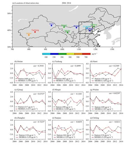
Fig.1.(a) Locations of the 9 stations of CMA and their PM10 concentration (color dot; μg m-3) in March-May (MAM) of 2004-2014, and (b-j)variations of PM10 concentration at the 9 stations and surface dust aerosol concentration from MERRA-2 in MAM of 2004-2014.The values with * pass the 95% confidence level.To compare the variation between station data and MERRA-2, the data in (b-j) are standardized.
2.3 Methods
To trace the source of local dust in North China(38°-45°N, 110°-118°E, shown in the black box of Fig.1a), we also analyze the relationship between daily dust concentration and wind during 1980-2014 from BCCESM1 historical experiments and MERRA-2.For each dataset, we first define a dust day as a day with dust concentrations above the 90th percentile for each grid of the whole region (30°-55°N, 70°-135°E) on all days during 1980-2014.Then, the dust days in North China from 1980 to 2014 are selected.Finally, the correlation between daily dust loads averaged for North China on these dust days and the daily wind speed in northern China at different levels (surface, 800, 700, and 500 hPa)on corresponding 0-2 days before these dust days are calculated.
3.Results
3.1 Present-day climate of dust aerosols in northern China
Here, we verified the reliability of dust data from MERRA-2 in northern China by comparing them with the PM10concentration from 9 ground-based observations.As shown in Fig.1a, the 2004-2014 mean PM10concentrations in northern China are generally high in the west and low in the eastern part of northern China.There are two centers in northern China, one with the highest value located in Tazhong and Hetian of southern Xinjiang (80°-90°E), and the other located in Ejinaqi and Minqin of western Inner Mongolia (100°-105°E).It is noted that the dust concentrations from MERRA-2 systematically underestimate the PM10at the 9 dust storm stations.The diversities between MERRA-2 and CMA data mainly come from the following aspects.MERRA-2 data are the gridded averaged mean, while the CMA data are at stations and the locations of stations are usually at the edge of the desert.In addition, PM10observations at sites may partly include other types of aerosols and particulate matter except for dust aerosols, especially at some sites close to urban areas, such as Nanjiao and Chifeng stations.Moreover, the data from MERRA-2 only constrain the AOD from the satellite, which partly contributes to the discrepancy between MERRA-2 and CMA data.Nevertheless, the year-to-year variation in the standardized spring (March-May) dust concentration mean from 2004 to 2014 for MERRA-2 and station data are generally consistent with each other.For example, in Wulate (Fig.1g) and Ejinaqi (Fig.1e) in central and western Inner Mongolia, and Zhangbei (Fig.1h), the correlation coefficient of the two series exceeds 0.67,passing the 95% confidence level.Therefore, the dust data in MERRA-2 can be used to study the evolution of dust in northern China.
Figure 2 shows the spatial distribution of the columnintegrated dust aerosol concentrations (hereafter, dust loads) from MERRA-2 and BCC-ESM1 in northern China from 1980 to 2014.Dust in northern China is mainly concentrated over 35°-45°N.There are two centers, one in southern Xinjiang and the other in the region from the central and western Inner Mongolia Plateau to the Hexi Corridor, with dust loads exceeding 400 and 200 mg m-2, respectively.These two centers correspond to the Taklamakan Desert and the Badain Jaran Desert,respectively.Studies have shown that dust storms occurring in these two centers can often cause dust events in most of northern China through dust transport by atmospheric circulation (Sun et al., 2001; Wang et al., 2004;Wang et al., 2005; Wang et al., 2008; Wu et al., 2021).BCC-ESM1 (Fig.2b) can simulate the distribution of dust in northern China, with a spatial correlation coefficient of 0.73, which passes a 95% confidence level.However, the dust loads of BCC-ESM1 are lower than those of MERRA-2, which may be caused by the difference in the subsurface area between MERRA-2 and BCC-ESM1.In addition, the locations of the dust centers in BCC-ESM1 slightly deviate from those in MERRA-2, which is in the region from eastern Xinjiang via Gansu to western Inner Mongolia.

Fig.2.Averaged monthly dust loads (mg m-2) from (a) MERRA-2 and (b) BCC-ESM1 in northern China during 1980-2014.
The geographical distribution of dust loads is mainly determined by dust emissions.The spatial distribution of the 2001-2014 dust emissions from BCC-ESM1 in contrast to the DuEM data are shown in Fig.3.There are also two obvious centers of dust emissions in BCCESM1, which is similar to the distribution of the dust loads in Fig.2b, one is in eastern Xinjiang and the other in western Inner Mongolia, although the west center in BCC-ESM1 is relatively to the east compared to that in DuEM, and the east center in BCC-ESM1 is relatively to the west.The values of dust emissions in BCC-ESM1(Fig.3b) are lower than those in DuEM (Fig.3a), which may cause the lower dust loads in BCC-ESM1.
The dust loads show a strong seasonal cycle (Fig.4).It peaks in spring and is the lowest in winter, and the dust loads reach over 100 mg m-2in most areas of Northwest China.BCC-ESM1 can approximately simulate the seasonal variation of dust.Spring (March-May) is the season with frequent dust events in China (Wang et al.,2005; Guan et al., 2017).In the following sections, the analysis mainly focuses on spring dust.
3.2 Variation in dust loads in northern China since 1980
Figure 5 shows the variation in spring dust loads in the main dust zones (35°-45°N) of northern China from 1980 to 2014.Both MERRA-2 and BCC-ESM1 clearly show that their dust centers in northern China have significant interannual variation.
Based on the above analysis, we explore the trend of spring dust loads over northern China, especially over North China, from 1980 to 2014 (Fig.6).In MERRA-2(Fig.6a), the dust loads significantly increase, especially in the region from Xinjiang via northern Qinghai and Gansu to western Inner Mongolia in northern China and Mongolia.However, the dust trend in North China is not obvious.In BCC-ESM1 (Fig.6b), the dust loads are basically decreasing in most provinces of northern China,especially from the center of the Inner Mongolia Plateau to North China.

Fig.3.Distributions of dust emission (μg m-2 s-1) averaged over 2001-2014 from (a) DuEM and (b) BCC-ESM1 in northern China.

Fig.4.Seasonal distributions of dust loads (mg m-2) averaged over 1980-2014 from MERRA-2 (left column) and BCC-ESM1 (right column) in northern China.
We focus on the trend of spring dust loads in the late 20th century (1980-2000) and the early 21st century(2001-2014) in Fig.7.In the late 20th century (Figs.7a,b), spring dust loads increase near Gansu and west of the Inner Mongolia Plateau in both MERRA-2 and BCCESM1.However, there are some differences in the trends on dust loads in some other regions between MERRA-2 and BCC-ESM1.For example, the dust in southern Xinjiang increases in MERRA-2 but decreases in BCCESM1.In North China, dust loads decrease significantly in MERRA-2 in the late 20th century, while they increase in most of North China but decrease in the northeast of this region in BCC-ESM1.In the early 21st century (Figs.7c, d), dust loads in North China decrease significantly in both MERRA-2 and BCC-ESM1.In addition, it can be found that the decreasing trends of spring dust concentration in North China are clear in MERRA-2 during both 1980-2000 and 2001-2014, while it is not evident during 1980-2014, which may be caused by a significant increase in dust from 1998 to 2000 as shown in Fig.5a.
The differences in the trend of dust loads may come from dust emissions that rely on atmospheric circulation and land surface conditions from BCC-ESM1.Therefore,we further explore the trend of dust emissions in DuEM and BCC-ESM1 from 2001 to 2014 (Fig.8).The amounts of dust emissions in both DuEM and BCCESM1 decreased in most of northern China from 2001 to 2014, which matches the consistent reduction in dust in Figs.7c, d.The increase in dust emissions in southern Xinjiang in MERRA-2 (Fig.8a) can cause an increasing trend in the dust loads (Fig.7c).In addition, there is an increase in dust concentrations in BCC-ESM1 (Fig.7d)from 2004 to 2014 in some regions with less local dust emissions (Fig.3b), such as the Tibetan Plateau and Northeast China.The increases in dust in these regions may be caused by the long-range circulation transport from some other regions.
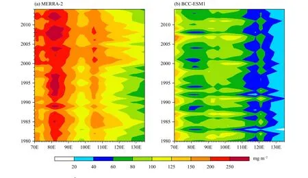
Fig.5.Evolution of dust loads (mg m-2) in China (30°-55°N, 70°-135°E) in spring (March-May) averaged over 1980-2014 from (a) MERRA-2 and (b) BCC-ESM1.

Fig.6.Distributions of linear trend coefficient of dust loads (mg m-2 decade-1) in spring of 1980-2014 from (a) MERRA-2 and (b) BCC-ESM1.The black box denotes North China.Values significant at the 95% confidence level using a Student’s t-test are stippled.
3.3 Variation in dust days in northern China since 1980
Using daily dust aerosol loads, spring dust days are identified by the method described in Section 2.The amounts of 213 and 37 mg m-2are the 90th percentile threshold dust loads for MERRA-2 and BCC-ESM1, respectively.The distribution of spring dust days (Figs.9a,b) is similar to that of the dust loads (Figs.2a, c).More of the dust days occurred in the 35°-45°N zone.There are two regions where dust days occur more frequently in MERRA-2 (Fig.9a), the Tarim Basin of southern Xinjiang and western Inner Mongolia Plateau to the Hexi Corridor.These two centers in BCC-ESM1 are connected in east-central Xinjiang to the Hexi Corridor (Fig.9b),which is consistent with the result in Fig.2b.There are fewer spring dust days in BCC-ESM1 than in MERRA-2.In North China, the distributions of spring dust days in MERRA-2 and BCC-ESM1 are similar to each other,showing a decreasing distribution from southwestern to northeastern North China and an average of approximately 15-20 days per year, which is close to the results in previous studies (Guo and Xie, 2008; Duan et al., 2022).
The linear trend coefficient distributions of spring dust days from 1980 to 2014 are shown in Figs.9c, d.In North China, the dust days in the whole spring season slightly decrease in MERRA-2 (Fig.9c) and more obviously decrease in BCC-ESM1 (Fig.9d).Dust days in most of northern China in MERRA-2, especially in the region from northern Xinjiang to the Hexi Corridor, and in the Hexi Corridor in BCC-ESM1 significantly increase.Overall, BCC-ESM1 can reasonably reproduce the distribution of dust days and its trends in northern China, especially in North China.
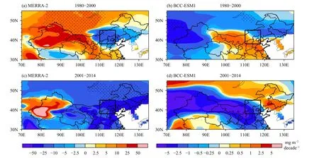
Fig.7.As in Fig.6, but for (a, c) MERRA-2 and (b, d) BCC-ESM1 during (a, b) 1980-2000 and (c, d) 2001-2014.

Fig.8.Distributions of linear trend coefficient of dust emission [μg m-2 (10 yr)-1] from (a) MERRA-2 and (b) BCC-ESM1 in spring of 2001-2014.Values significant at the 95% confidence level using a Student’s t-test are stippled.
3.4 Reason for the dust decrease in North China
Zhou et al.(2023) suggested that local wind is the dominant driver of dust in dust source areas of East Asia,based on the relative importance analysis of different factors including surface wind speed, air temperature,and soil moisture.Wu et al.(2022) also showed that surface wind plays a dominant role in the dust decline in Asia.Stronger surface winds often bring more dust to the dry underlying surface.The decreasing trend of surface and atmospheric wind speed can reduce the dust emission in dust source regions and the transport of dust aerosols respectively, which can lead to a decrease in dust loads and the number of dust events.
We use the method in Section 2 to estimate the total days of dust that occurred in spring 1980-2014 in North China, which are approximately 15-20 days per year.Figure 10 illustrates the longitude-height profile of spring dust load and wind for the domain (38°-45°N,70°-135°E) from MERRA-2 and BCC-ESM1 simulations.As shown in Fig.10, there are some obvious differences in the lower atmosphere (below 800 hPa) between MERRA-2 and BCC-ESM1, which may be caused by the original dust data in MERRA-2 being pressure level data and its dust concentration below 800 hPa being generally extra-interpolated, the different topography used,and the different method for averaging.Overall, both of them show that much dust occurs between the Hexi Corridor and central Inner Mongolia on 0-2 days before dust days in North China, which corresponds to the Badain Jaran Desert and other deserts, and provides an important source of dust for North China.Dust concentrated below 750 hPa in the source regions is transmitted upward to the 500-hPa level, and then transported into North China by westerly winds.Previous studies (Sun et al.,2000; Bian et al., 2011; Luo et al., 2022) also showed that dust in Northwest China can be transported to affect the weather conditions in North China.Recently, Chen et al.(2023) showed that Mongolia is another dust source contributing to northern China, especially in the spring of 2023.
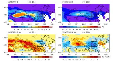
Fig.9.Distributions of (a, b) spring dust days (day) and (c, d) their linear trend coefficient (day decade-1) from MERRA-2 and BCC-ESM1 averaged over 1980-2014.The black box denotes North China.Values significant at the 95% confidence level using a student’s t-test are stippled in (c, d).

Fig.10.Longitude-height profiles of spring dust concentration (μg m-3) and wind vectors over the domain 38°-45°N, 70°-135°E from (a-c)MERRA-2 and (d-f) BCC-ESM1 during the 0-2 days before the dust day of North China in 1980-2014.The vertical wind speed is magnified by a factor of 100.
According to the method in Section 2.3, we calculated the correlations between daily dust loads averaged for North China on spring dust days with the wind speed at different levels (surface, 800, 700, and 500 hPa) in northern China (30°-55°N, 70°-135°E) on corresponding 0-2 days before these dust days from 1980 to 2014.Figures 11 and 12 present the spatial distributions of their correlations for MERRA-2 and BCC-ESM1, respectively.BCC-ESM1 (Fig.12) is basically similar to MERRA-2(Fig.11).Both show that the dust loads in North China have a significant positive correlation with wind speed upstream, which can be traced back to northwestern China.Dust in North China is significantly positively correlated with wind speed at the surface and lower atmosphere from the central and western Inner Mongolia Plateau to the Hexi Corridor and even western Mongolia,which we call the “dust core” region (38°-45°N,90°-105°E, shown in the left box in Figs.11, 12), especially at one day before the dust days in North China.The positive correlation between dust and wind at the surface and lower atmosphere (800-700 hPa) is more significant than that at the upper atmosphere (500 hPa).

Fig.11.Distributions of correlation coefficient between dust loads on the dust day in North China and wind speed at (a-c) 500, (d-f) 700, (g-i)800 hPa, and (j-l) surface level in the whole domain (30°-55°N, 70°-135°E) 0-2 days before the dust day from MERRA-2 during 1980-2014.Vectors show the averaged wind in these days.Values of the correlation coefficient not significant at the 95% confidence level of a Student’s ttest are masked in white.

Fig.12.As in Fig.11, but for BCC-ESM1.
We explore the 1980-2014 year-to-year changes in spring dust in North China and wind speed in the lower-middle troposphere from the near surface to 500 hPa in the “dust core” region.As shown in Fig.13, their variations have high positive correlations.The highest correlation is located at 700 hPa for MERRA-2 (up to 0.69) and at 800 hPa for BCC-ESM1 (up to 0.77).As a result, we further explore the influence of average wind at 700 and 800 hPa on dust.
Figures 14a and 14b present the climatological mean of the horizontal wind averaged at 800 and 700 hPa.The“dust core” region is not the strong northwesterly wind zone and is just west of North China.The trend of wind speed over the “dust core” region can reasonably account for the dust trend in North China.For MERRA-2 data, from 1980 to 2014, spring wind speed in the “dust core” region decreases in the northern dust core region but increases in the south (Fig.14c), and there is a slight reduction in spring dust days (Fig.9c) and no evident trend in spring dust loads in North China (Fig.6a).The decreasing trend in wind speed in the dust core region may cause the dust load trend in North China to be obviously smaller than that in the surrounding region.In BCC-ESM1, the decreasing trend in wind speed decreases by approximately 2 m s-1decade-1(Fig.14d),which causes a decrease in spring dust days (Fig.9d) and dust loads (Fig.6b).The remarkable decrease of wind in most of Mongolia also partly contributes to the reduction of dust in this period.Therefore, the variation of the wind in the lower-middle troposphere over the “dust core” region is an important reason for the trend of spring dust in North China.
4.Summary and discussion
In this study, we analyze the basic spatial and temporal characteristics and variation of dust loads over northern China (30°-55°N, 70°-135°E, i.e., most areas north of the Yangtze River), especially over North China(38°-45°N, 110°-118°E, i.e., the area inclusive of Beijing, Tianjin, central Inner Mongolia, and northern Shanxi and Henan), using MERRA-2 reanalysis data and BCC-ESM1 simulation data.Furthermore, we use daily data to discuss the possible reasons for the variation of dust over North China.The main findings are as follows.

Fig.13.Variations of spring dust loads (black lines), dust days (red lines) in North China, and spring wind speed at different levels (surface:yellow lines; 800 hPa: green lines; 700 hPa: blue lines; and 500 hPa: purple lines) over the “dust core” region from (a) MERRA-2 and (b) BCCESM1 during 1980-2014.Correlation coefficients between the variation of dust loads and the other variables are shown in the legends next to the figure.The correlation coefficient is significant at the 99% confidence level using the Student’s t-test if it is larger than 0.42.All the series are standardized.
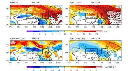
Fig.14.Distributions of (a, b) spring 800- and 700-hPa averaged wind speed (m s-1) and (c, d) their linear trend coefficients [m s-1 (10 yr)-1]from (a, c) MERRA-2 and (b, d) BCC-ESM1 over 1980-2014.The black box in the west denotes the “dust core” region, and that in the east refers to North China.Values significant at the 95% confidence level of a Student’s t-test are stippled in (c, d).
(1) Dust in northern China is mainly concentrated over 35°-45°N, with two dust centers in southern Xinjiang and in the region from central and western Inner Mongolia Plateau to the Hexi Corridor, which correspond to the Taklamakan Desert and Badain Jaran Desert, respectively.Both centers show obvious seasonal cycles, with high dust concentrations in spring and summer and low concentrations in autumn and winter.BCC-ESM1 can generally simulate the main features of the temporal and spatial distributions of dust in northern China.
(2) During 1980-2000 and 2001-2014, the decreasing trends of spring dust in North China are evident in MERRA-2 and BCC-ESM1, although the spatial distribution and amplitude of the linear trend are slightly different between the two data sources.The total number of dust days in MAM in North China also decreases evidently in MERRA-2 and BCC-ESM1 during 1980-2014.In addition, the amounts of dust emissions in both DuEM and BCC-ESM1 consistently decrease in northern China from 2001 to 2014.
(3) The dust in North China during the dust days mainly comes from the upstream “dust core” regions(38°-45°N, 90°-105°E), especially from the central and western Inner Mongolia Plateau (the Badain Jaran Desert and other dust areas), and is closely related to the wind speed in the “dust core” region during the 0-2 days prior to the dust day.The wind reduction at the lower-middle troposphere during 1980-2014 in the “dust core” regions is one of the important reasons for the decrease of spring dust in North China in recent years.
In this paper, however, the following challenges are meanwhile found: the dust loads are underestimated and the centers of dust have some offset in BCC-ESM1 compared to MERRA-2.It is important to improve the simulation of dust in BCC-ESM1.Improving the simulation of the wind and its variations in the lower-middle troposphere over the “dust core” region will definitely help further understand the trends of dust in North China.The model data analyzed in this study are from the coarse resolution version of BCC-ESM1.Higher model resolution may improve the model’s capability in reproducing the dust loads and winds and their variations.This shall be analyzed in a future work.
Acknowledgments.We acknowledge Meteorological Observation Centre, China Meteorological Administration for providing the observed surface PM10data.We also acknowledge all data developers, their managers,and funding agencies for contributing to the datasets used in this study.
杂志排行
Journal of Meteorological Research的其它文章
- Changes in Atmospheric Circulation during the Winter Regional Extreme Cold Events over China since 1960
- Changes in Persistent Precipitation in Northwest China and Related Large-Scale Circulation Features
- Predictability and Risk of Extreme Winter PM2.5 Concentration in Beijing
- Operational Plan, Effect Verification, and Key Technical Settings for a Stadium-Scale Artificial Rain Reduction Experiment
- Random Forest-Based Snow Cover Mapping in China Using Fengyun-3B VIRR Data
- Refined Spatialization of 10-Day Precipitation in China Based on GPM IMERG Data and Terrain Decomposition Using the BEMD Algorithm
