Research and application of environmental risk assessment model for marine mobile risk sources
2023-02-20CAOShengwenSONGEnhuiFUYuTONGXinSONGLili
CAO Shengwen,SONG Enhui,FU Yu,TONG Xin,SONG Lili*
1.Technology Innovation Center of Marine Information,Tianjin 300171,China;
2.National Marine Data and Information Service,Tianjin 300171,China
Abstract: Based on the analysis of AIS data characteristics of ships transporting dangerous goods by sea, a comprehensive environmental risk assessment index system for marine mobile risk sources based on human factors,ship factors,navigation environment, natural environment and risk receptors was constructed, a risk assessment model was established by using the analytic hierarchy process, three risk levels were divided, and case studies and application services were carried out in the northern waters of Hangzhou Bay, providing reference for decision-making management of relevant departments.
Keywords:AIS data,mobile risk sources,risk assessment,gradation
According to statistics, about 90% of China's import and export trade is transported by sea, with dangerous goods accounting for about 50% of the sea freight volume[1].According to the national standard "Identification of Major Hazard Sources for Hazardous Chemicals"(GB 18219-2009),hazardous materials have characteristics such as explosive,flammable, toxic, and harmful, which can easily cause serious disasters to personnel,environment, equipment, and affect the coordinated development of society, environment,and economy.With the rapid development of the shipping industry in recent years,the risk of dangerous goods leakage into the sea has also been increasing.On November 4,2018,a petrochemical product transport ship at Quanzhou Port in Fujian Province leaked,causing 69.1 tons of carbon nine products to leak into the offshore area,resulting in pollution to the surrounding ecological environment of the port area[2]; In March 2012, the Singaporean ship "BARELI" hit a reef and ran aground near Jiangyin Port in Xinghua Bay,Fuzhou, leading to a large amount of dangerous goods such as fuel and organochlorine pesticides to leak into the sea, causing marine ecological losses in the nearby waters[3].In order to effectively deal with the risk of dangerous goods leakage, China has successively issued and implemented laws and regulations such as the Production Safety Law of the People's Republic of China (Presidential Decree No.13), Identification of Major hazard of Dangerous Chemicals (GB 18218-2009), Regulations on the Safety Management of Dangerous Chemicals (State Council Decree No.591), and Interim Provisions on the Supervision and Management of Major hazard of Dangerous Chemicals (Order No.40 of the State Administration of Work Safety).The identification method for major hazard sources of hazardous materials has been established, and it is clearly required to conduct classification and quantitative risk assessment for major hazard sources of hazardous materials.
The transportation process of dangerous goods at sea is complex, and there are many factors that affect their safety, with strong contingency and randomness.Therefore,the marine environmental hazards generated after leakage are more difficult to predict,making it difficult to quantify and evaluate risks.At present, the quantitative evaluation research on the safety of maritime transport of dangerous goods mainly adopts the relative comparative law, analytic hierarchy process, and fuzzy comprehensive evaluation method[4-6].The evaluation indicators mainly adopt the five major safety factors of dangerous goods transportation, namely "people, machinery, goods, management, and environment".The rationality of the selected indicators will directly affect the quality of the evaluation method results;At the same time,AIS data can provide the main characteristic parameters of ships,record navigation status,and other information,and is mainly applied in two aspects: channel environmental risk[6,8,9]and ship collision[10,11].It has become an important research direction for maritime traffic safety risk.
This article mainly focuses on the impact of sudden accidents of hazardous materials at sea on the nearby marine environment.Based on the experience of experts in the field,factors such as planned ship routes, accident situations, recent maintenance times, draft,real-time ship density in the vicinity, and marine functional zoning are included in the environmental risk assessment index system of hazardous material movement risk sources at sea.The Analytic Hierarchy Process is used to calculate the index weights of the evaluation model.The research results can provide real-time identification and risk level warning of dangerous goods movement risk sources in the monitoring sea area,providing support for decision-makers to adjust emergency monitoring forces in a timely manner.
1 Data analysis
1.1 AIS data
AIS is a new type of digital navigation system and equipment composed of shore-based (base station) facilities and onboard equipment,integrating network technology, modern communication technology, computer technology, and electronic information technology.It achieves information transmission and exchange between ships and shore through ship identification and dynamic information collection functions, playing a very important role in navigation safety, traffic control, and maritime management[12].At present, AIS is almost universally applied to all ships, and AIS data is mainly divided into three categories: static information, dynamic information, and voyage information[13](Tab.1).
In Tab.1, the dangerous goods (types) in the voyage information are manually entered at the beginning of the voyage, but specific goods and quantities are not required to be specified.This information helps determine whether the ship is loaded with dangerous goods.The input parameters are composed of DG, HS, MP, and X, Y, Z, OS combinations[14].Among them, DG represents dangerous goods, HS represents harmful substances, and MP represents marine pollutants; X.Y, Z, and OS are four classification levels of hazards to marine resources or human health specified by the International Maritime Organization (IMO):X represents major hazards,Y represents potential hazards,Z represents minor hazards, and OS represents no hazards.For example, HS(Y)represents a hazardous substance that causes harm.
1.2 Ship archives
The ship archives contain information on international navigation ships with a total tonnage of over 300 tons worldwide, as well as shipowners and management companies,shipyards, and other related information.Ship archive data is collected by IHS Market Maritime and Trade, an official designated agency of the International Maritime Organization(IMO),and is widely used in fields such as ship leasing,port piloting,maritime supervision,border inspection and law enforcement,and ship services.The content of ship archive data includes detailed technical parameters of ships and equipment, construction status, protection and compensation associations, classification and PSC inspection records, owner, operator, trading situation, accident situation, and other authoritative archive data(Tab.2).

Tab.2 Main Information of ship archives
1.3 Data analysis
It can be seen from Tab.1 and Tab.2 that AIS and ship archive data contain rich maritime traffic information.Using Big data mining technology,we can dig out the indicator factors related to the mobile risk sources of dangerous goods at sea from these information.
(a) Dangerous goods transport vessel: Based on the types of dangerous goods in AIS data, the vessel and cargo hazard level for transporting dangerous goods can be accurately identified.Combined with ship archive data, information such as vessel age,whether accidents have occurred,recent repair time,and company name can be obtained.
(b) Real time ship location: Based on the longitude and latitude data of ships in AIS data, the channel information and ship density can be further calculated.Combined with ocean functional zoning data, the sea use information of the ship's location can be determined.
2 Construction of index system
The factors that affect the safety of maritime dangerous goods transportation have the characteristics of multi-level and multi factorial factors.In order to accurately obtain evaluation results, it is necessary to consider the coverage range of indicators, the interrelationships between indicators, and the convenience of obtaining indicator data.Taking into account the safety process and related safety factors in the transportation of dangerous goods at sea, this article uses the Analytic Hierarchy Process to set the hierarchical structure of the evaluation index system as the target layer,criterion layer,and indicator layer.Among them, the target layer is to construct an environmental indicator evaluation system for the mobile risk sources of dangerous goods at sea.The criterion layer considers five aspects: human factors, ship factors, navigation environment, natural environment, and risk receptors.The indicator layer is further refined into 13 indicators(see Fig.1).For ease of calculation,each indicator is divided into 3 levels.
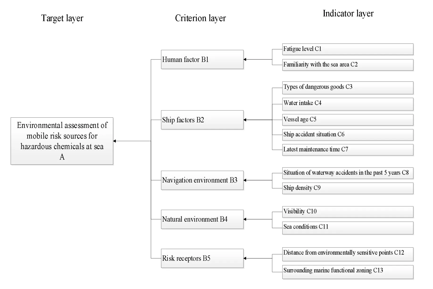
Fig.1 Environmental indicator evaluation system for mobile risk sources of dangerous goods at sea
C1 Fatigue level: Based on the voyage information in the AIS of the ship, the start time of the planned route can be obtained, which is used to calculate the travel time of the ship.The longer the travel time, the easier it is for the crew to fatigue, and the ability to handle ship emergencies will decrease.It is divided into three levels according to the travel time ≥15 days,5-10 days,and<5 days.
C2 Familiarity with the sea area: Reflects the ability of crew members to plan their routes in advance.Based on real-time AIS location information of the ship,the jurisdictional country of the sea area can be identified, and the nationality of the ship company can be obtained from the ship's IMO number in the ship's archive data.Usually,crew members are familiar with their own country's sea area.If nationality cannot be obtained,it will be treated as uncertain and divided into three levels:unfamiliar,uncertain,and relatively familiar.
C3 Types of dangerous goods: Whether the ship is carrying dangerous goods is the focus of this indicator system research.The higher the level of harm to the marine environment caused by dangerous goods,the greater the harm to the marine environment caused by accidents.According to the types of dangerous goods X (major harm), Y(causing harm),and Z(minor harm),they are divided into three levels.
C4 Water intake:It reflects the cargo carrying capacity of a ship.The larger the draft,the greater the transportation volume of dangerous goods,and the greater the harm to the marine environment caused by accidents.It is divided into three levels based on the ship's draft ≥10m,5-10m,and<5m.
C5 Vessel age: By using the ship's IMO number,the delivery date of the ship can be obtained from the ship's archive data.The longer the age, the more severe the equipment wear and tear,and the greater the likelihood of triggering ship safety incidents.The ship is divided into three levels based on its age ≥10 years,5-10 years,and<5 years.
C6 Ship accident situation: By using the ship's IMO number,the accident situation of the ship can be obtained from the ship's archive data,reflecting the overall risk and control status of the ship.According to the statistics of accidents occurring ≥3 times, 1-3 times,and<1 time,it can be divided into 3 levels.
C7 Latest maintenance time:By using the ship's IMO number,the latest maintenance time of the ship can be obtained from the ship's archive data.The closer the maintenance time is, the more stable the equipment is, and the less likely it is to trigger a safety event.According to the maintenance time ≥3 years,1-3 years,and<1 year,it is divided into three levels.
C8 Situation of waterway accidents in the past 5 years:The name of the channel can be obtained through ship location data,and the occurrence of accidents in the channel can be counted, reflecting the overall risk status of the channel.It is divided into three levels based on the occurrence of major accidents,general accidents,and no accidents.
C9 Ship density: reflects the number of other ships in the vicinity at that time.Through ship position data,the density of ships within 1km can be obtained.The more the number,the greater the probability of collision.According to the number of nearby ships ≥5,3-5,<3,it is divided into 3 levels.
C10 Visibility: Reflects the visible distance of the sea surface in the nearby sea area at that time, and obtains the ocean weather forecast of the sea area through ship position data.It is divided into three levels according to the visible distance<1km,2-5km,≥5km.
C11 Sea conditions: Sea area weather forecasts can be obtained through ship location data.There are a total of 18 wind power levels, which are divided into 3 levels based on wind power levels ≥10,6-10,and<6.
C12 Distance from environmentally sensitive points: By calculating the distance between the ship's location and the functional zoning of the surrounding sea area, the degree of impact of hazardous material leakage on the marine environment is reflected.It is divided into three levels based on distances of<5km,5-10km,and ≥10km.
C13 Surrounding Marine Functional Zoning: Reflects the degree of safety sensitivity of the marine environment caused by hazardous material leakage to different marine functional zoning.According to the Technical Guidelines for Marine Oil Spill Ecological Damage Assessment(HY/T 095-200), the marine ecological environment is divided into three levels:sensitive zone,sub sensitive zone,and non sensitive zone.
3 Construction of environmental risk assessment model
3.1 Principles and applications of analytic hierarchy process
Analytic hierarchy process (AHP) is a kind of hierarchical weight decision analysis method proposed by Saaty T L,an American operations research scientist at the University of Pittsburgh in the early 1970s.It applies network system theory and multi-objective comprehensive evaluation method,which is suitable for solving complex problems that are difficult to measure directly and accurately.
The principle of Analytic Hierarchy Process is as follows:
(1)Hierarchy Model Construction
Classify the factors involved in the problem, divide the complex problem into various constituent factors,and construct a hierarchical structure model.
(2)Construction of judgment matrix
Using Thomas Setty's 1 - 9 scale method, the importance of each factor within the sam e criterion or indicator layer in the hierarchical structure is com pared in pairs.The relative scale is shown in Tab.3 to m inim ize the difficulty of com paring multip le factors w ith different properties and im prove accuracy.

Tab.3 Scale and m eaning o f 1-9 judgm en t m atrices
By using expert scoring to construct several judgm ent m atrices for prim ary and secondary indicators, it is assum ed that the criterion layer has several prim ary indicators 1B,2B,…,Bn,the im portance com parison judgment matrix for target layer A is
The importance com parison judgm entmatrix for the first levelindicator,records the im portance levelof the second leve l indicatorsandrelative toas
(3)Solution and Consistency Check of Judgment Matrix
Use the sum product method to solve the matrix, and the calculation steps are as follows:
a) Divide each term in the matrix by the sum of each term in the corresponding colum n to standardize the matrix,the formula is
b)Take the mean of each row of the new matrix to obtain the eigenvectorof each factor,the formula is
c) Due to subjective factors in expert scoring, the constructed judgment matrix has inconsistency issues.It is necessary to verify the consistency of each matrix and calculate the maximum eigenvalue of each matrixA.the formula is
d)Calculate the consistency indicatorCI,the formula is
e) WhenCI=0, it indicates that the matrix is consistent, and the larger theCI, the more severe the consistency of the matrix;By looking up Tab.4 with the matrix ordern,the random consistency indexRIcan be obtained.The formula for calculating the consistency ratio is

Tab.4 Random consistency indicators
Tab.5 Maximum characteristic values
f) WhenCR<0.1, it indicates that the degree of inconsistency of the matrix is within the allowable range.Otherwise,the judgment matrix constructed earlier should be adjusted until it passes the consistency check.
3.2 Calculation of judgment matrix for mobile risk source analysis and evaluation model
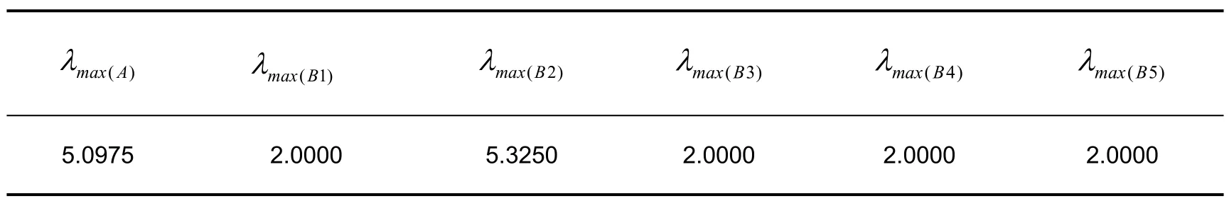
Based on the established environmental risk assessment index system for mobile hazardous materials at sea,an expert scoring table is designed using a 1-9 scale method.From October 2019 to May 2020, the research team utilized methods such as email communication and on-site meetings to invite 30 experts with senior professional titles or above from various organizations including the National Marine Information Center, the National Marine Environment Monitoring Center, the Shanghai Maritime Safety Administration, the East China Sea Environmental Monitoring Center of the State Oceanic Administration,the North Sea Forecast Center of the State Oceanic Administration,Ocean University of China, the Second Institute of Oceanography of the Ministry of Natural Resources,and Sinopec Qingdao Safety engineering Research Institute, to fillin the"Environmental Risk Assessment Scoring Table for Mobile Risk Sources of Dangerous Goods at Sea".The research fields involved marine chemistry,environmental assessment,risk research,marine engineering,etc.A total of 18 experts received the scoring table.The highest and lowest scores of each indicator were removed respectively, and the average score of each indicator was calculated and substituted into the AHP formulas (1) and (2),the judgment matrices for the target layer and criterion layer can be obtained as follows:
According to the consistency test results of formulas (6) and (7), the CR of each indicator level is<0.1,which meets the consistency test(Tab.6).

Tab.6 Consistency test of judgment matrix
3.3 Risk assessment model weight calculation results and risks
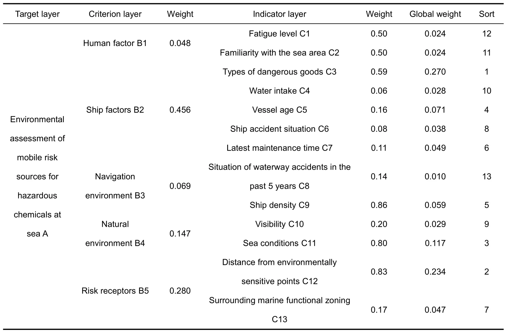
Based on the final weight results of various factors in the criterion layer and indicator layer calculated by the above judgment matrix, the specific global weights and rankings of various indicator factors in the environmental risk assessment index system for marine hazardous material movement risk sources can be obtained(Tab.7).
Tab.7 Weights and ranking of risk source evaluation indicators for mobile dangerous goods at sea
According to the results of the Analytic Hierarchy Process, the weight of the types of dangerous goods transported by ships is 0.270,and the distance weight of sensitive points in the marine environment is 0.234, respectively ranking first and second in the comprehensive ranking of the indicator layer.They are key indicators for environmental risk assessment of mobile risk sources of dangerous goods at sea.
3.4 Risk level classification
According to the high, medium and low risk levels of the 13 risk elements in the indicator layer, the values are respectively assigned as 3 points, 2 points and 1 point.Combined with the specific weight of each risk element in Tab.7, the final score of the marine mobile risk source can be calculated between 5 and 15 points.According to the principle of equal division, the following mobile risk source level standards are defined(Tab.8).

Tab.8 Classification of risk levels for mobile risk sources of dangerous goods at sea
4 Application of environmental risk assessment model
In order to test the applicability of the evaluation index system of mobile risk sources at sea, dangerous goods transport ships in the northern waters of Hangzhou Bay are selected as research cases to evaluate the level of mobile risk sources.There are various marine functional zones near the sea area, such as passenger terminals, container terminals,coastal wetlands,marine nature reserves,scenic tourist areas,residential areas,agricultural and fishery areas.The real-time AIS data is sourced from the East China Sea Navigation Support Center of the Ministry of Transport, updated every 15 minutes, and covers the northern waters of Hangzhou Bay;The marine weather forecast data is sourced from the website of the China Meteorological Administration,and the historical data of ship archives is sourced from the shipping Big data project of the National Marine Information Center.
4.1 Data sources
The real-time AIS data is sourced from the East China Sea Navigation Support Center of the Ministry of Transport, updated every 15 minutes, and covers the northern waters of Hangzhou Bay;The marine weather forecast data is sourced from the website of the China Meteorological Administration,and the historical data of ship archives is sourced from the shipping Big data project of the National Marine Information Center.
4.2 Instance application
Taking the data obtained from 8:00 am on December 30, 2022 as an example, AIS data was processed and analyzed by the system, and a total of 73 ships were obtained,including 7 dangerous goods transport ships;On that day,the sea was foggy,with visibility of less than 1 kilometer and a wind force of level 6; There are various marine functional zones near the sea area, such as passenger terminals, container terminals, coastal wetlands, marine nature reserves, scenic tourist areas, residential areas, and agricultural and fishery areas.
Based on the above existing ship AIS,archives and the surrounding sea environment and other data, the environmental risk assessment model was used to carry out Real-time computing and classification of seven dangerous goods transport ships, including five low-risk and two medium risk; The risk element values of one of the dangerous goods transport ships with IMO number 84578XX (based on ship safety principles, the last two digits are replaced by'X')are shown in Tab.9.The indicator calculation result of the ship at 9:00 am is 8.84, which belongs to medium risk.The indicator calculation results of other dangerous goods ships are shown in Tab.10.

Tab.9 Environmental risk status of mobile risk source for ship IMO number 84578XX
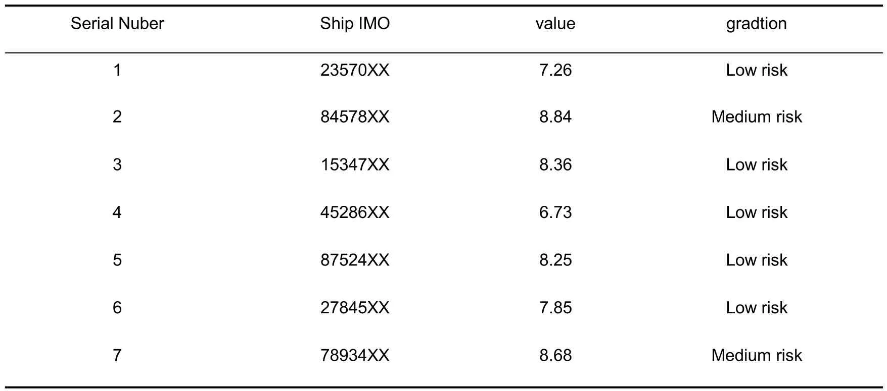
Tab.10 Classification of 7 dangerous goods transport ships at 9:00 pm on the sea
5 Conclusion
This article focuses on the complex and difficult quantitative analysis of safety risk factors in the transportation of dangerous goods at sea.Based on AIS data mining of dangerous goods transportation ships, a comprehensive evaluation of five major risks in the transportation process, namely human factors, ship factors, navigation environment,natural environment, and risk receptors, is conducted.The Analytic Hierarchy Process is used to calculate the weight of indicators and establish an environmental risk assessment model for mobile risk sources of dangerous goods at sea.This model has been applied in the emergency assistance system for maritime hazardous material accidents, providing guarantees for marine safety.
This paper only establishes a classification level early warning for maritime dangerous goods transport ships, while decision-makers usually pay more attention to regional risks, and should further use Big data mining and analysis technology, combined with other parameters such as destination port, estimated arrival time, ship speed, etc.from AIS data, to predict the route and time of multiple dangerous goods transport ships passing through a sea area at the same time in advance,and establish a regional risk level early warning,timely optimization of the emergency monitoring personnel and material layout in the jurisdictional sea area,and early prevention of marine environmental pollution are of great significance.
Acknowledgments
This work was supported by the project of China Knowledge Centre for Engineering Science and Technology(Grant No.CKCEST2022-1-4).
杂志排行

Marine Science Bulletin的其它文章
- Sea level change and vertical land motion along Ny-Alesund coast in Arctic
- Study on motion characteristics of Nioghalvfjerdsfjorden
- Study on the refined classification method of mangrove tree species based on Sentinel-2 MSI images combined with object-oriented
- Establishment and analysis of GNSS coordinate time series noise model for coastal tide stations in China
- Practice of marine data sharing:a case study of online sharing for marine data in private network environment