Spatiotemporal Variations and Driving Factors of Coastline in the Bohai Sea
2022-12-27ZHANGLeiLIGuangxueLIUShidongWANGNanYUDiPANYufengandYANGXue
ZHANG Lei, LI Guangxue, , LIU Shidong, WANG Nan, YU Di,PAN Yufeng, and YANG Xue
1)College of Marine Geosciences, Ocean University of China, Qingdao 266100, China
2)Key Laboratory of Submarine Geosciences and Prospecting Techniques, MOE, Ocean University of China,Qingdao 266100, China
3)College of Oceanic and Atmospheric Sciences, Ocean University of China, Qingdao 266100, China
Abstract The utilization and protection of coastlines play a crucial role in the sustainable development of coastal cities. The coastline designations in recent years have witnessed more coastal areas worldwide undergoing significant land reclamation for agriculture,industry, and urbanization purposes. This study used remote sensing images from 1986 to 2016 to analyze spatiotemporal changes in the coastlines of 13 cities around the Bohai Sea, which cover one city (Tianjin City)and three provinces (Liaoning, Hebei, and Shandong).Using coastline and socioeconomic data from 1986 to 2016, a partial least-squares regression (PLSR)model was established to analyze factors affecting the utilization of coastlines in each city. The results showed that from 1986 to 2016, the retention rates of natural coastlines in the cities around the Bohai Sea decreased, and the overall coastline expanded toward the sea. Furthermore, the impacts of human activities were prominent on the silty mud and sandy coastlines. Economic development, population growth, and urbanization were the main drivers of the development and construction of coastal cities, which changed the coastlines around the Bohai Sea to a state of high-intensity use. In addition, national macro policies and the external market environment indirectly drove the intensity of coastline use through regulations and interventions in cities. However, there were significant differences in the levels of development of the cities surrounding the Bohai Sea. In the future, the differences in the original coastal resources and urban development planning must be considered, the traditional parameters of economic development must be changed, the efficiency of coastline utilization must be improved, and urban clusters must be integrated.
Key words Bohai Sea; urbanization; coastline changes; coastline utilization degree; driving force
1 Introduction
The coastal zone is a transitional area between land and sea, where the atmosphere, hydrosphere, lithosphere, and biosphere converge and interact. It is also sensitive to natural or anthropogenic disturbances (Scherneret al., 2013;Lorenzoet al., 2018). The coastal environment has a wide range of impacts on the biosphere and society, including biodiversity conservation, flood control, water purification,coastline stabilization, storm protection, recreation, and tourism (Cao and Fox, 2009). However, in recent years, erosion in coastal areas has increased due to reduced sediment supply, human activities, hydrodynamic changes, and regional tectonic activity (Yinet al., 2012; Webbet al., 2013;Maet al., 2014; Fanet al., 2018). The coastline is important for protecting the environment and maintaining the ecological balance of the coastal zone (Liuet al., 2018).The spatiotemporal evolution of the location, direction, shape,and utilization of coastlines is not only an intuitive manifestation of landscape changes in a coastal zone but also an external embodiment of the interactions among regional ecological function, environmental protection, economic development, and policy orientation (Liu and Jezek, 2004).With the improvement of remote sensing techniques, multiple satellite image resources in conjunction with geographic information systems (GIS)have been used successfully for analyzing and extracting surface water boundaries(Feyisaet al., 2014; Caoet al., 2020).
At present, coastline change research has become the most common and effective method for characterizing coastal environmental changes. Scholars from various countries have focused on two main aspects of coastline change: extracting coastline change information and characterizing the spatiotemporal variability of coastlines through the combination of remote sensing images and GIS (Houet al., 2016; Liet al., 2018b; Aiet al., 2019). These studies have explored the impacts of climate, geology, human activities, and economy on coastlines by analyzing spatiotemporal changes in the coastlines (Liet al., 2018b; Zhuet al., 2018; Thoaiet al., 2019; Sunet al., 2020). Many methods have been proposed and applied to extract the coastlines, including visual interpretation (Liet al., 2018a), multispectral classification (Maglioneet al., 2014; Hsiaoet al., 2016), and image segmentation (Zhanget al., 2013).
Over the past 40 years, China has experienced continuous and rapid economic growth, with coastal areas becoming the most economically developed and densely populated areas. As a result, there have been extensive exploitations of coastlines for aquaculture, port construction, and tourism purposes (Özdemir Işık and Demir, 2017). However, the intensive coastal development has changed the balance of the marine environment in the country’s bays,causing the shrinking of the wetlands and coastlines (Liet al., 2014). In recent years, China’s coastal provinces and cities have generally shown an overall declining trend in resource and environmental carrying capacity levels. In particular, the resource and environmental carrying capacities of most areas in Liaoning and the near-shore waters of Yantai are already at their maximum, while those of the near-shore waters of Tianjin, Hebei, Dongying, Binzhou,and Huludao are overloaded (Ding, 2019). Moreover, the ecological risk to the Bohai Bay-Yellow River Estuary zone has been increasing for the past 40 years (Wanget al., 2021).
In the past, studies on the Bohai coastal zone have explored the drivers of coastline change and coastal reclamation for the Yellow River Delta, individual bays, or the entire region (Xuet al., 2016b; Xuet al., 2019). However,research on coastal changes based on provincial and municipal administrative units is lacking. To date, no studies have combined the urban economic development levels and coastline utilization status to explore the factors driving coastline utilization in different types of cities. Therefore, the current study aims to explore 1)the degree of spatiotemporal changes and utilization status of the coastlines of cities surrounding the Bohai Sea from 1986 to 2016 by obtaining relevant data through the visual interpretation of remote sensing images; 2)the factors driving coastline utilization in the Bohai coastal cities using indicators of socioeconomic categories; and 3)the potential pathways for sustainable development of these cities. The results of this study can help in introducing scientific decision-making for sustainable socioeconomic development, maintaining ecological balance, and developing further resources in the bay areas.
2 Data and Methodology
2.1 Study Area
The study area is located within the economic circle of the Bohai Sea, including the coastal distribution within the Bohai Sea areas in Liaoning Province (Dalian, Yingkou,Panjin, Jinzhou, and Huludao), Hebei Province (Qinhuangdao, Tangshan, and Cangzhou), Shandong Province (Binzhou, Dongying, Weifang, and Yantai)and Tianjin City,which play a critical role in promoting global economic cooperation and the coordinated development of northern and southern China. The studied coasts include Liaodong Bay, Bohai Bay, and Laizhou Bay, which are located in 37˚1′ – 40˚57′N and 117˚32′ – 123˚30′E (Fig.1). Changes in the coastal zone around the Bohai Sea have been significantly influenced by human activities. At different times, the original characteristics of the coastal zone have changed due to human activities, such as sea-farming, transport-related construction, and port construction (Zhuet al., 2014; Fenget al., 2018). There are 13 cities of various sizes, all of which are economically active. The acceleration of economic development, heavy chemical industry development, coastal distribution of the industrial layout, clustering of urban development, and increased urban population density have all dramatically changed the coastline of the Bohai Sea, resulting in substantial pressure on the resources, environment,and ecology of the Bohai Sea area (Xuet al., 2016b).
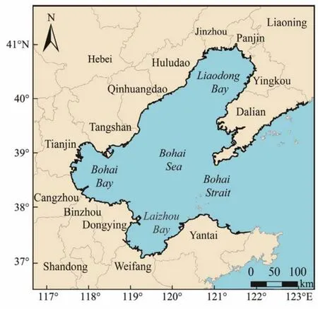
Fig.1 Geographical location and administrative divisions of the study area.
2.2 Remote Sensing Data Sources and Processing
In this study, a series of Landsat images from multiple sources, including Landsat TM and Landsat OLI, were used to monitor coastal reclamation and coastline changes from 1986 to 2016. A total of 40 cloud-free images covering the study area were acquired from the USGS (https:// glovis.usgs.gov/)and were preprocessed using atmospheric correction, geo-rectification, image repair, and image enhancement (Xuet al., 2016a). The processed images were used in GIS software for the visual human-computer interpretation of the coastline.
2.3 Coastline Analysis
2.3.1 Coastline classification and interpretation
Multi-year sea and land boundary data corresponding to high tide levels were adopted for defining the coastline(First Institute of Oceanography, 2017). Linear dams with widths of less than 50 m and protruding to the sea, thus deviating significantly from the general coastal direction,were excluded from the total length of the coastline but were used for auxiliary coastline measurement (Zhang, 2009).The coastline was divided into natural and artificial coast lines according to the change in their natural states (Zhanget al., 2014; Xuet al., 2016a). The details of each type of coastline interpretation are shown in Fig.2.
2.3.2 Coastline variation trend
The linear regression rate (LRR)method (Mahapatraet al., 2014; Himmelstosset al., 2018)was used to quantify coastline changes in each city along the Bohai Sea from 1986 to 2016. The LRR of coastline change is a leastsquares linear regression fit to a dataset of intersection distances between the coastline and the profile during the study period. The slope of the fitted line is the LRR (m yr-1).
2.3.3 Analysis of coastline utilization degree
The degree of utilization was first applied to land, ecological landscape, and other related fields (Suiet al., 2020).Wuet al.(2014)applied the same to study the degree of coastline utilization and obtained relatively good results.The current study used different human action intensity indicators for each coastal section based on the characteristics of different coastal types and the intensity of the human influence on the Bohai Sea (Table 1).The index of coastline utilization degree (ICUD)is the comprehensive utilization index. The greater the value ofICUD, the greater the interference of human factors, and the more difficult it is to revert to the natural coastline.ICUDis computed as:

wherenis the number of coastline types, andAiandCirepresent the intensity of human interference and the percentage of the length of coastline type I, respectively. In this study,ICUDwas used to analyze the impacts of socioeconomic activities on the coastline around the Bohai Sea and as a dependent variable to analyze the factors driving changes in the Bohai Sea coastline.
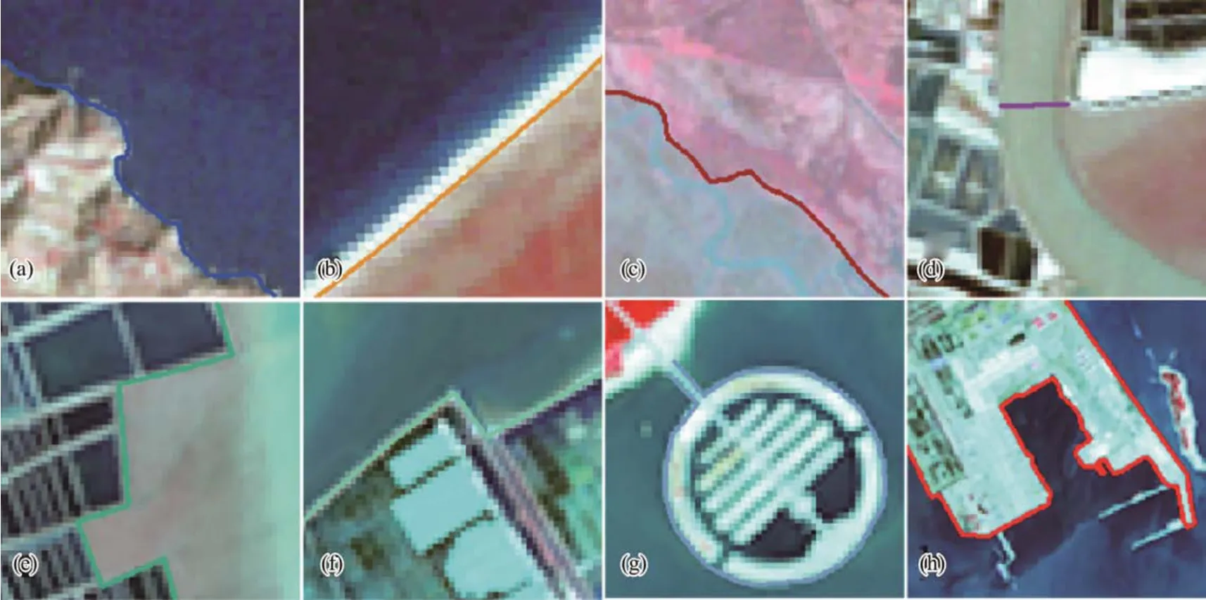
Fig.2 Schematic diagram of coastline interpretation. (a), bedrock; (b), sandy; (c), silty-clayey; (d), estuarine; (e), aquaculture embankment; (f), salt field embankment; (g), construction embankment; (h), port wharf coastline.

Table 1 Human activity intensity index in different sections of the Bohai Sea
2.4 Analysis of Factors Based on the PLSR Model
Partial least-squares regression (PLSR)is a new type of multivariate statistical data analysis method (Woldet al.,1983). Owing to the further refinement of its theory and methodology, it is widely used in different fields, such as economics, sociology, environment, ecology, and remote sensing. This method can effectively overcome the limitations of general regression modeling methods and is particularly suitable for analyzing data with multicollinearity and several independent variables (Woldet al., 2001; Palermoet al., 2009; Abdi, 2010; Zhanget al., 2015). The PLSR method specifies a linear relationship between a set of dependent variables (Y-variables,ICUDin our case)and a set of driving variables (X-variables, the potential driving factors). The validity of the PLSR model can be assessed based on the goodness of fit (R2Y)and variable importance of projection (VIP). In general, the dependent variable can be significantly explained by an independent variable, which has a VIP greater than 1.0 and cannot be significantly explained if the value is less than 0.5. The interval between 0.5 and 1 is termed a ‘gray zone’.
The relationship between socioeconomic factors and coastline change was analyzed by quantifying various factors related to the existing data on the potential driving factors of coastline changes (Zhanget al., 2015; Menget al.,2017). Indicators with the different units cannot be combined directly unless they are standardized (Weiet al.,2014). In this case, due to the differences in the units of various indicators, the original data need to be standardized.Then, SPSS was used to test the indicators for multicollinearity and stepwise regression to screen out variables with significant effects and no multicollinearity. A total of 14 socioeconomic variables were selected (Table 2). The economy is the foundation of urban development. The gross domestic product (GDP)of the coastal regions, gross output value of industrial (GOVI)areas, and the gross output value of agriculture (GOVA)were used to reflect each city’s current economic development level. Disbursement of foreign capital (DFC)reflects the external attractiveness and international competitiveness of a city. Per capita retail sales of consumer goods (PCRSCG)reflect changes in the urban retail market and the level of economic prosperity. Per capita quantity of aquatic products (PCQAP)and port handling capacity (PHC)reflect the current development of a city’s marine industry. The goal of urban development is the overall development of society. Thus,population density (PD)and natural growth rate of the population (NGRP)were selected to reflect the size and demographic situation of the city, respectively. Moreover,the proportion of the urban population (PUP), area of the built district (ABD), and the average wage of employed staff and workers (AWESW)reflect the level of urbanization. Coastline retention rate is CRR; Per capita coastline length is PCCL. Historical economic and social data from coastal areas between 1986 and 2016 were collected from the Statistical Yearbooks of the State Oceanic Administration (SOA).
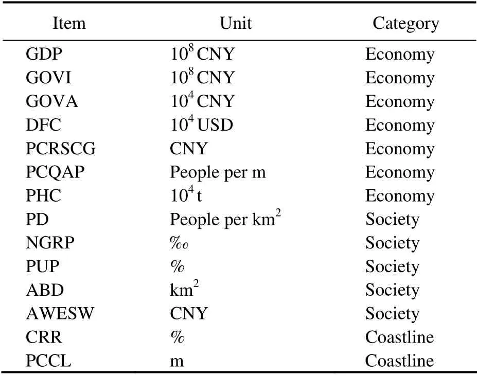
Table 2 Selected socioeconomic indicators used in this case as explanatory variables in the PLSR models
3 Results
3.1 Spatiotemporal Change in the Bohai Sea Coastline
The coastline structure refers to the length ratio of various coastlines in a certain area. The impact of human activities on the coastline can be reflected in the changes in various natural and artificial coastlines in different periods.The interpretations of coastline types from remote sensing satellite images from 1986, 1996, 2006, and 2016 are shown in Fig.3. As can be seen, from 1986 to 2016, the tortuosity and length of the Bohai Sea coastline continued to increase(Fig.3). The total length of the coastline in 1986 was 3161.85 km, which increased by 1304.04 km or 41.24% in 30 years. Meanwhile, the proportion of natural coastline in the Bohai Sea has been decreasing, from 58.96% in 1986 to 17.92% in 2016. Over time, the coastline structures of the Bohai Sea cities have changed significantly (Fig.4), with the proportions and types of natural coastlines showing an overall decreasing trend. In 2016, Tangshan, Tianjin, and Cangzhou, located in Bohai Bay, had less than a 1% shoreline retention rate. Bohai Bay is a semi-enclosed, gently sloping silty bay, and the silty-clayey coastline was massively developed during 1986 – 1996 (Fig.4). High-intensity polder makes the average flow velocity of high and low tide in Bohai Bay decrease, which in turn aggravates the degradation of the Bohai Bay area’s environmental quality(Houet al., 2017).
The valid sections (i.e., the sections where the four points do not intersect, excluding the null and false values)were graded and defined according to the LRR values (Fig.5).In the last 30 years, 72.80% of the coastline in the Bohai Sea has advanced seaward, especially the coastlines of the Liao River Estuary, the southern coast of the Bohai Sea,the Yellow River Estuary, and the southern coast of Laizhou Bay have pushed toward the sea massively. The mudflats in these areas were once more developed, and by 2016, the silty mud coastline had greatly reduced. Approximately 16.57% of the coastline has eroded landward, with the areas that have receded being further concentrated landward near the Yellow River Estuary, mainly due to extensive erosion of the mudflats. Furthermore, the areas where the coastline is retreating but not changing dramatically are concentrated in the southern end of Liaodong Bay, the eastern coast of Laizhou Bay, and the eastern end of the Shandong Peninsula, all of which have predominantly sandy coastal substrates. The weak coastline changes in the Bohai Sea account for only 10.63% of the total coastline and are concentrated mainly in the eastern part of the Liaodong Peninsula and Zhifu Island in the Shandong Peninsula,where the coastline types are dominated by bedrock and sandy coastlines.
3.2 Changes in the Degrees of Coastline Utilization
Since the 21st century, the increased degree of coastal development in Bohai Bay has accelerated the development of the entire Bohai Sea. Currently, the three provinces and one city around the Bohai Sea have surpassed the Yangtze River Delta and Pearl River Delta regions in terms of coastline utilization (Wuet al., 2014). The overall coastline utilization degree in the Bohai Sea continued to increase from 181.94 in 1986 to 287.75 in 2016, with substantial changes observed in Yingkou, Jinzhou, Huludao,and Yantai (Fig.6).
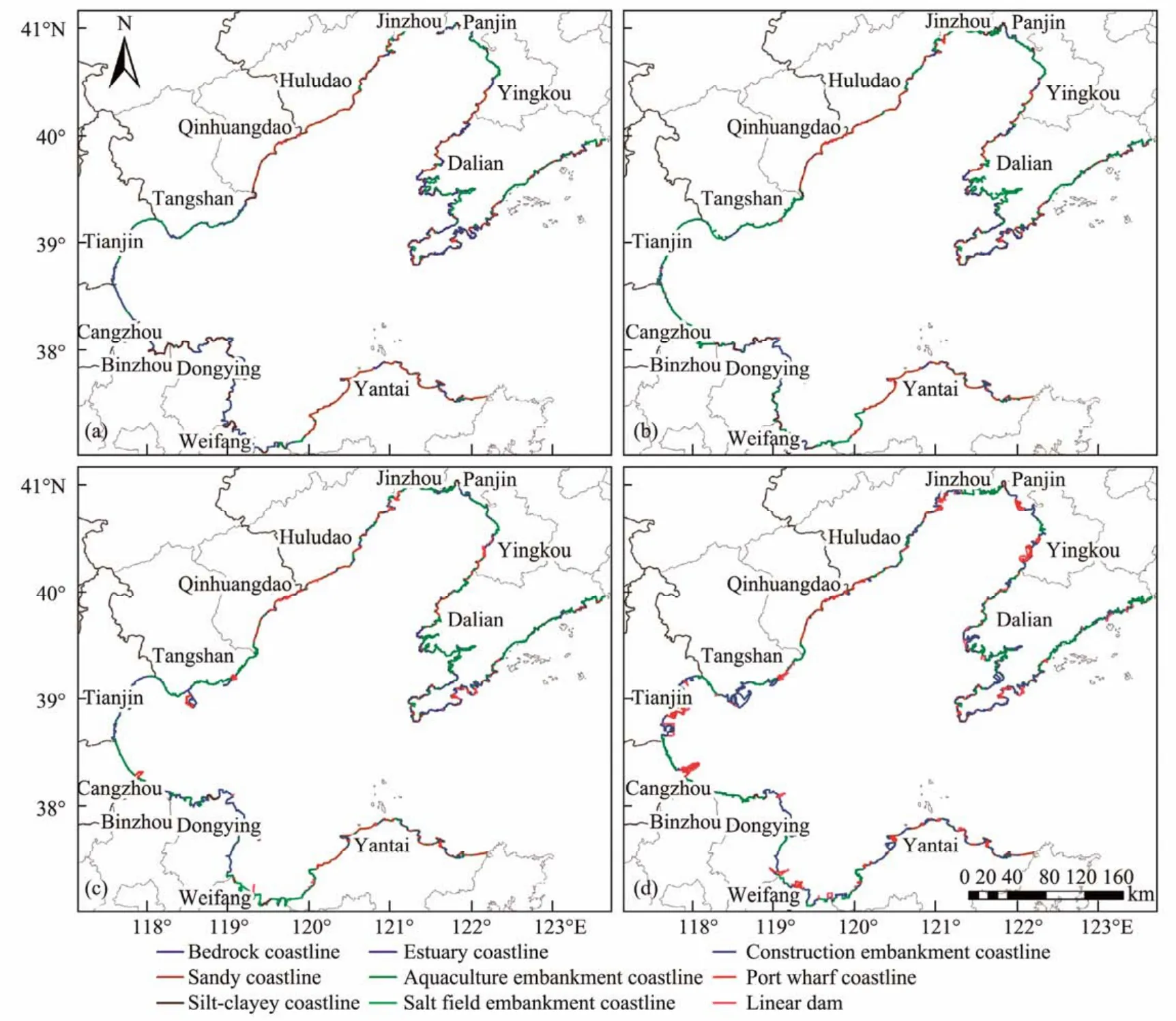
Fig.3 Distribution of the coastline around the Bohai Sea in1986 (a), 1996 (b), 2006 (c), and 2016 (d).
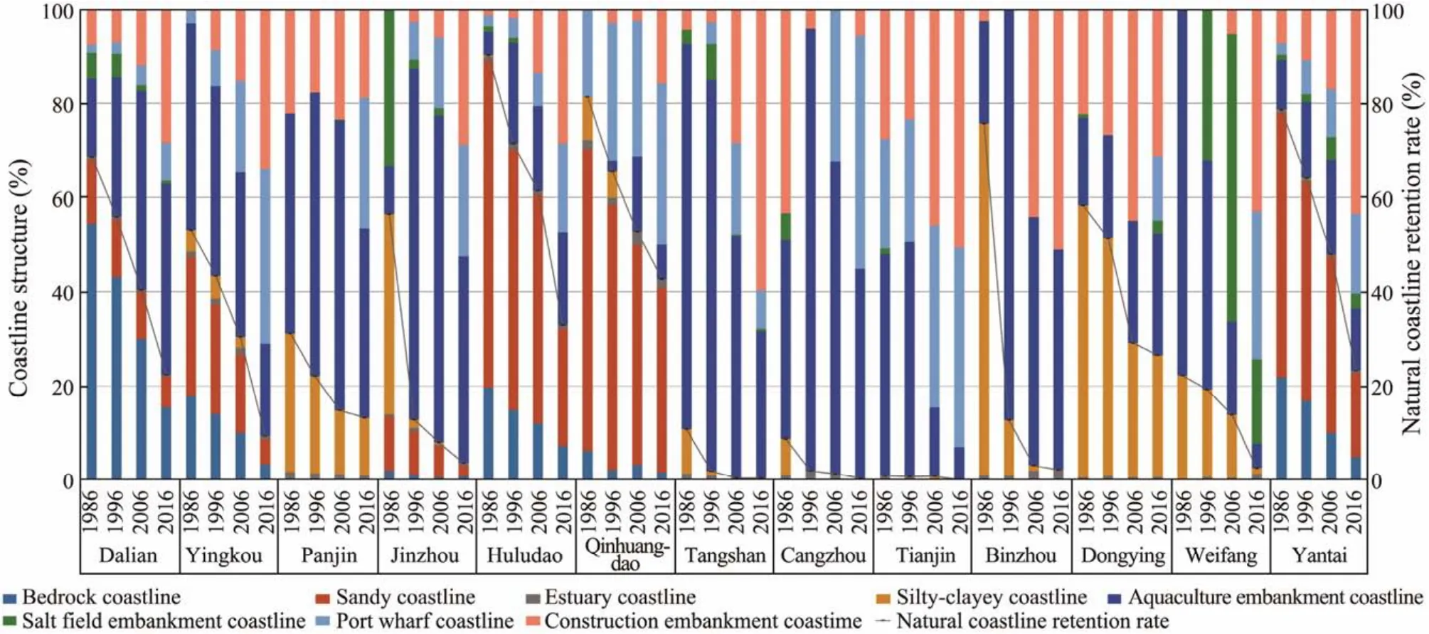
Fig.4 Schematic map of coastline structure changes in cities surrounding the Bohai Sea.
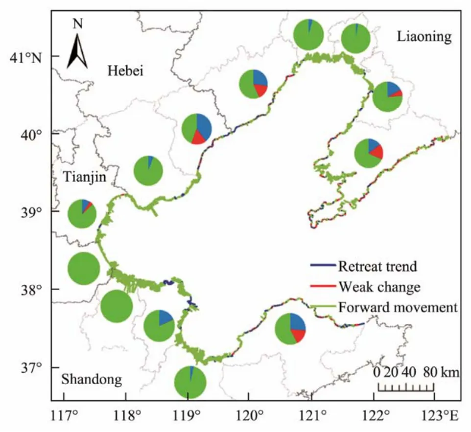
Fig.5 Changes in linear regression rates (LRR)along the Bohai Sea coastline. Using the LRR method, the longterm trends of the coastline around the Bohai Sea from 1986 to 2016 can be analyzed. The coastlines with rate values less than -0.5 m yr-1 and greater than 0.5 m yr-1 are defined as the retreat trend and the forward movement coastlines,respectively, while the shoreline with a rate value ranging between -0.5 and 0.5 m yr-1 corresponds to the weak change coastline.
In 1986, the coastline in the Bohai Sea had a high proportion of natural coastline, with the construction of artificial coastlines dominated by aquiculture areas (Fig.4)and a low level of overall coastline utilization (Fig.6). Since then, the rapid development of the farming and salt industries has led to the rapid growth of the aquaculture embankment and salt field embankment coastlines in the Bohai Sea region. Moreover, theICUDincreased slightly in 1996, although the subsequent decline in the coastal farming and salt industries has reduced the coastline as well. Urban development has led to an increase in demand for land,as manifested in the expansion of cities and the construction of integrated coastal functional areas, resulting in the rapid growth of theICUDafter 1996.ICUDincreased in all cities during 2006 – 2016, with the top three values corresponding to Weifang, Yingkou, and Yantai.
3.3 Overview of Urban Coastline Changes in the Bohai Sea
Coastline changes are closely linked to the original coastal type and the municipalities’ plans for the coastal zone(Fig.4). Silt mud and sandy coastlines are easier to use and develop, whereas bedrock coastlines are relatively difficult to develop. Cangzhou and Binzhou are located on the western and southern coasts of Bohai Bay, respectively, both with fully seaward advancing coastlines. The rich silty mud coastlines of the two cities are conducive to farming and the construction of salt pans surrounding the sea. The average rate of coastline advancement in Binzhou City is 524.00 m yr-1. Panjin, Jinzhou, Tangshan, and Weifang all have more than 90% of their coastlines advancing toward the sea.Dongying and Tianjin have over 80% of their coastlines advancing seaward. For many years, Tianjin has been reclaiming land, and its coastline structure is uneven and heavily artificial. Dongying is rich in mudflats and wetlands. From 2006 to 2016, part of the coastline advanced seaward due to the diversion of the Yellow River Estuary, the formation of a delta lobe at the new estuary, the completion of the Dongying Port, and the expansion of the farming area.
The coasts of Dalian, Yingkou, Huludao, and Yantai are dominated by bedrock and sandy shores, while the weak change coastlines of the four cities account for 72.78% of the weak change coastlines in the Bohai Sea. The average rate of seaward advancing coastline is approximately 25 –50 m yr-1, and the erosion of bedrock and sandy coastline retreats the coastline. Qinhuangdao is located on a sandy shore with abundant sandy coastal resources. In this area,the average rate of forwarding movement of the coastline over the last 30 years has been 11.95 m yr-1, but the overall percentage of retreat in the coastline is nearly 40%.

Fig.6 Index of coastline utilization degree (ICUD)in prefecture-level city administrative region. ICUD values ranged from 1 to 400 (unitless), with higher ICUD values reflecting the increased difficulty in restoring the coastline to its natural state and decreased coastline structures.
Through their own resource advantages and geographical location, the cities in the Bohai Sea first developed resource-based industries. Tianjin, Tangshan, and Cangzhou in Bohai Bay and Weifang in Laizhou Bay had more farming areas and salt pans in 1986 because of their rich silty mud coastlines, while the remaining cities’ coastlines were less exploited and had high retention rates of natural coastlines. From 1986 to 1996, the cities in the Bohai Sea entered the sea-farming stage. Along with the process of opening up to the global economy, Tianjin took the lead in developing a port economy, which led to the construction of the Binhai New Area. Between 1996 and 2006, several ports of varying sizes were built in various cities, and the ports of Dalian, Qinhuangdao, and Tianjin were all established as large international ports. During this time, Tangshan and Tianjin entered the land reclamation stage. From 2006 to 2016, the increase in reclamation projects and the increasing construction of ports led to larger increases inICUD.
3.4 Major Socioeconomic Indicators of Coastline Utilization Change
The large differences between the variables may also have an impact on the reliability of the model results, as the cities have a wide range of economic strengths due to their natural environment and resource conditions. Therefore, the current study used hierarchical cluster analysis to reduce the impact of regional differences on the model results (Regeret al., 2007). To identify patterns of coastline utilization for each city, we collected information on GDP and calculatedICUDand coastline retention rate for 2016. The coastline retention rate andICUDreflect the development intensities and utilization rates of the coastlines around the Bohai cities. GDP can reflect the economic strength of each coastal city and the economic benefits gained by developing the coastline. The results of the classification indicated the existence of different coastline utilizations considering the three variables.
The types of coastline utilization patterns and attributes(TCUPA)for each group are summarized in Table 3. Tianjin is a TCUPA I city and far exceeds the other cities in terms of economic strength and coastline utilization, with only 0.09% of its natural coastline remaining. The TCUPA II cities of Dalian, Dongying, and Yantai have medium levels of GDP and high proportions of natural coastline.The TCUPA III cities of Qinhuangdao and Huludao have low levels of coastline utilization and a natural coastline proportion of over 30%. The TCUPA IV cities of Tangshan and Weifang are second only to Tianjin in terms of GDP and the comprehensive use of coastline, with the proportions of the natural coastline just above that of Tianjin. The GDP of the TCUPA V cities of Yingkou, Panjin, Jinzhou,Cangzhou, and Binzhou is lower than the average Bohai Sea GDP. The degree of coastline utilization in Panjin is lower than the Bohai Sea average, while theICUDof other cities is higher than 300.
For each TCUPA category, the mean value and standard deviation (Std.)are calculated by the indicator values for each group of cities.
Owing to the differences in the dimensions and magnitudes of various indicators, the original data were first standardized, and the indicators were then tested for multicollinearity. Correlation and variance expansion factor tests showed multicollinearity between the variables. Therefore,the PLSR model was used to analyze the factors driving the comprehensive utilization of the coastline. The results(Table 4)revealed that GDP, GOVI, GOVA, PCRSCG, and AWESW served as the main drivers of the degree of integrated coastline use in the five TCUPA groups (VIP > 1).DFC, PCQAP, PD, NGRP, and PUP were considered significant drivers only once in each of the five groups. The selected socioeconomic variables explained 68.48% of the variation inICUDin Tianjin. The increased coastline utilization was driven by increases in GOVI, GOVA, PCAQP,PHC, PUP, ABD, and AWESW (VIP = 1.006 – 1.187). For the TCUPA II cities, the model explained 62.72% of the variation inICUD, with the highest VIP value for CRR(VIP = 1.554), followed by the AWESW (VIP = 1.421). Socioeconomic factors explained 80.89% and 85.75% of the differences inICUDfor TCUPA category III and IV cities,respectively. GDP, GOVI, PCRSCG, AWESW, and CRR were the significant drivers common to both groups. Changes in socioeconomic factors explained 76.17% of the variation in the comprehensive utilization of the coastline in the TCUPA V cities. Furthermore, seven variables had VIP values greater than 1, of which GDP, GOVA, PCRSCG, PHC,ABD, and AWESW had positive impacts on ICUD, while CRR had a negative impact.

Table 3 Statistical analysis of the variables used to characterize the types of coastline utilization patterns and attributes (TCUPAs)
4 Discussion
4.1 Main Natural Factors of Coastline Changes
Siltation and erosion are the main natural factors causing coastline changes. Sediment deposition is a determinant of coastal variability at longer time scales. The sediments carried by large rivers are deposited around the mouth of the sea, exceeding the erosion and transport effects of the ocean on land sediment and leading to the formation of a wide estuarine delta due to the natural silt (Georgeet al.,2019; Twilleyet al., 2019). In turn, this forms silty mud coastlines or sandy coastlines, which eventually change the estuarine coastline. Since the diversion of the Yellow River to the Qingshuigou flow path in 1976, the Yellow River Delta as a whole has been in a continuous process of dynamic changes in flushing and siltation, and the evolution of coastal flushing and siltation has varied significantly in different periods (Huang and Fan, 2004; Liu, 2017).The spatiotemporal variation of this flushing and siltation state is influenced by a combination of the amount of incoming marine sand from the Yellow River, the topography of the estuarine waters, and the ocean dynamics conditions(Liet al., 2020).
Furthermore, the natural erosion is heavily influenced by the sea tide, and the eroded coastline mainly consists of silty mud, sandy, and estuarine coastlines (Fig.3). Considered on a longer time scale, global warming-induced sea level rise is a common factor leading to shoreline retreat,and its cumulative effect is obvious even though the process is slow (Nicholls and Cazenave, 2010). In the future,sea levels will continue to rise in low-lying deltaic coastlines, and flat sandy coastlines are most affected by such a rise (Nicholls and Cazenave, 2010; Regueroet al., 2019).According to the China Sea Level Bulletin (State Oceanic Administration, 2021), since 1980, the sea level along the Bohai Sea has risen at a rate of 3.6 mm yr-1. The relative sea level of the Bohai Sea coast was predicted to rise by over 60 – 180 mm in the next 30 years, placing coastal communities at greater risk. Provinces and cities along the Bohai Sea have experienced frequent storms and typhoons and will be increasingly exposed to climate change impacts in the decades ahead (Wanget al., 2018; Zhanget al., 2021).
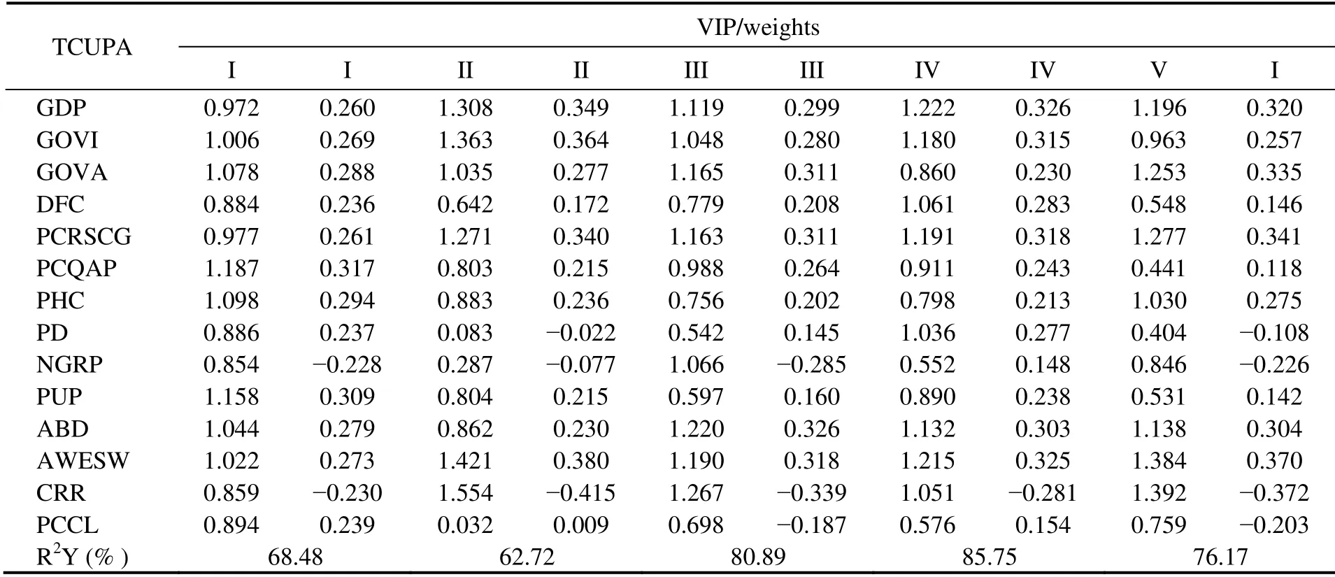
Table 4 Summary of the PLSR models that evaluated the relationships between ICUD and driving factors in different TCUPAs
4.2 Socioeconomic Driving Force
Based on the relationship between socioeconomic factors and coastline change in multiple TCUPAs, GDP, GOVI,GOVA, PCRSCG, ABD, and AWESW have been found to have significant positive impacts on the artificiality and degree of utilization of the coastlines in cities surrounding the Bohai Sea. Furthermore, the drivers of the comprehensive utilization degree of the urban coastline around the Bohai Sea are both internal and external to the cities. In terms of internal factors, the basic conditions of most cities near the Bohai Sea are relatively weak, indicating that the urban system must go through the stage of urban-scale expansion to achieve further development (Yang, 2013; Quet al., 2021). Land reclamation is a common practice globally (Suzuki, 2003; Wanget al., 2014; Menget al., 2017)and is generally higher in the coastal areas of China’s three major economic regions (Bohai Sea Rim, Yangtze River Delta, and Pearl River Delta). Approximately 35% of reclamation projects occur in the Bohai Sea (Tianet al., 2016).Anthropogenic activities, such as land reclamation and coastal engineering, are the main factors contributing to coastline changes (Mishraet al., 2019). With the refinement of resource allocation, marine fisheries, ship manufacturing, and marine transportation industries are clustered in the coastal zone along the Bohai Sea, which can inevitably lead to high degrees of coastline utilization in these areas in the future.
Along with the rise and development of related industries, such as finance, insurance, restaurants, and services,the construction of airports, ports, and residential and recreational facilities along the waterfront have also contributed to the growth of the cities’ GDP and various production values (Quet al., 2021). For municipalities, provincial capitals, sub-provincial cities, and general cities of different sizes, there are large differences in urban system functions, infrastructure, and urbanization levels, in which the more urbanized a city is, the higher the intensity of the coastline exploitation, as particularly observed in Tianjin during the study period. Tianjin has a natural location and resource advantage, which is reflected in the fact that Tianjin’s employment environment and living conditions attract foreign citizens. This has led to a rapid expansion of its population size and stronger demand for land expansion.Tianjin’s urban built-up area increased from 283 km2in 1986 to 1008 km2in 2016, with a PD of 1311 persons per km2.
In terms of external influences, the central government can effectively intervene by using macro policy adjustments to promote urban development and ensure balanced urban development among regions. Since 1986, when the ‘Bohai Economic Circle’ was first introduced into regional economic development plans, the Bohai Sea region has been an area of intense regional policy-level changes (Zhao, 2006).In recent years, the central government has implemented long-term control strategies to alleviate the dependence of urban development on land expansion by creating an institutional environment and introducing financial subsidies(Quet al., 2021). Such rapid development and large-scale economic activities have further stimulated the demand for labor, capital, and other factors of production, thus attracting foreign populations that led to large amounts of technology and capital from foreign investors, joint ventures, and multinational enterprises. The economic strength and market scale have also grown further, indirectly promoting the high-intensity utilization of the coastlines around the Bohai Sea.
4.3 Development Suggestions
There are large differences in the levels of economic development, infrastructure, industrial carrying capacity, population quality, and natural resources of cities around the Bohai Sea. These are related to both the differences in the original coastal resources and the current positioning of the city. Tianjin, a TCUPA I city with a high level of urbanization and limited resources, should adjust and improve its coastal zone development intensity and marine environmental quality in the future, thus playing the role of a core city. Meanwhile, TCUPA V cities, such as Yingkou, Panjin, Jinzhou, Cangzhou, and Binzhou, whose market consumption rates and economic levels need further development, should strengthen industrial support, increase external exchanges, and effectively introduce and utilize foreign investments to ensure their future development.
At the same time, the economic levels of the TCUPA II and III cities are similar. Dalian and Yantai have long sandy coastlines, while Dongying has abundant mudflat resources,which should be carefully exploited in the future, with a focus on sustainable, healthy, and environmentally friendly development. As there are several reclamation projects in Tangshan and Weifang, the existing development model should be sustained to optimize and improve the monitoring technology and the utilization efficiency of coastlines.Furthermore, as the TCUPA III cities of Huludao and Qinhuangdao are rich in sandy coastal resources, they may consider tourism revenue as an important source of GDP.During the study period, approximately 40% of the coastline of Qinhuangdao had eroded at an erosion rate of 4.18 m yr-1. Given that the sandy coastline of Huludao was reduced by 3 km, more attention should be paid to the protection and restoration of its coastline resources in the future.After that, it can focus on the improvement of tourism industry efficiency and the optimization of tourism factor inputs to enhance its overall development level.
The rapid development of China’s marine economy is overly dependent on the use of resources, which has led to various problems with resources and the environment,to the detriment of China’s overall economic development(Yu and Di, 2020). The restoration of the natural coastline retention rate, the efficient use of the coastline, and the harmonious development of the coastal zone environment are prerequisites for the long-term sustainable economic development of coastal cities. The Bohai Sea region is densely populated; thus, multiple ports share a common hinterland, and the space for fishery economic development has decreased (Fig.3). The convergence of industrial structure, overlapping of port function positioning, and increased competition are a few problems that persist (Wanget al.,2016; Luet al., 2018). In the future, the zoning control system and policy framework should be scientifically improved, and special breeding, tourism, and leisure breeding should be developed according to local conditions. More attention should also be given to the construction of an industrial chain that connects large and medium-sized enterprises in an orderly manner, thus improving cooperation in the Bohai Sea region.
Furthermore, the development of the regional collaborative construction of the Bohai Sea city cluster and the establishment of shared and common construction of urban municipal facilities and transportation facilities can lead to positive interactions between urbanization and agriculture modernization. Thus, the government’s supporting role in the sci-tech innovation of the marine industry should be promoted. In particular, various kinds of policy support from local governments are essential for the marine industry to conduct sci-tech innovation activities and improve its innovation efficiency (Xuet al., 2021). Moreover, regulations concerning coastal development should be strengthened,along with processes for the approval of reclamation planning and environmental impact assessment (Menget al.,2017). In addition, the traditional reclamation methods must be changed to foster more comprehensive environments and promote the ecological restoration of China’s coastal areas (Maoet al., 2019; Wanget al., 2020).
5 Conclusions
For more than 30 years, the Bohai Economic Circle has accounted for an increasing proportion of the national economy. At the same time, the degree of human-induced transformation of the Bohai Sea coastal zone has become increasingly intense. In this study, remote sensing technology was used to analyze the spatiotemporal changes in the urban coastlines of the Bohai Sea from 1986 to 2016.By analyzing the changes in theICUDof the Bohai Sea cities, the GDP and coastline retention rate data of each city in 2016 were used for cluster analysis, and the cities were classified into five categories based on their characteristics. Using coastline and socioeconomic data from 1986 to 2016, a PLSR model was developed to analyze factors affecting the extent of coastline use in each city.
The results showed that from 1986 to 2016, the length of the coastline in the Bohai Sea increased, the proportion of artificial coastline increased annually, and the overall coastline experienced a dominantly seaward expansion.Coastline change is closely linked to the original coastal type and the municipal planning of the coastal zone. Furthermore, the impact of human activities on coastline change is prominent in the silty and sandy shores, and the driving force of the comprehensive utilization of the urban coastline is embodied in both internal and external aspects. Internal factors, including the urban economic foundation,population growth, and urbanization level, are the direct driving forces. Meanwhile, the external factors mainly include national macro policies and the external market environment, which indirectly drive the high-intensity utilization of coastlines through the adjustment and intervention of internal factors.
Due to historical accumulation, there are large differences observed in the scale of cities surrounding the Bohai Sea,and full consideration should be given to the differences in the original coastal resources and the current positioning of these cities. In the future, the efficiency of coastline use should be improved, and marine resources should be developed rationally. Furthermore, cities in the Bohai Sea should focus on collaborative development, in which industrial chains that connect large, medium, and small enterprises are built in an orderly manner to further promote cooperation.
Acknowledgements
The study is supported by the Key Intergovernmental Special Project of the National Key R&D Program (No.2017YFE0133500), the Special Project for the Construction of Taishan Scholars, the National Natural Science Foundation of China (No. 41806072), and the Fundamental Research Funds for the Central Universities, China (No. 2019 13020).
杂志排行
Journal of Ocean University of China的其它文章
- A Theoretical Model for the Microwave Emissivity of Rough Sea Surfaces
- Mechanism of Regional Subseasonal Precipitation in the Strongest and Weakest East Asian Summer Monsoon Subseasonal Variation Years
- Analytical and Experimental Studies on Wave Scattering by a Horizontal Perforated Plate at the Still Water Level
- Theoretical Prediction of the Bending Stiffness of Reinforced Thermoplastic Pipes Using a Homogenization Method
- Penetration Resistance of Composite Bucket Foundation with Eccentric Load for Offshore Wind Turbines
- Application of Converted Displacement for Modal Parameter Identification of Offshore Wind Turbines with High-Pile Foundation
