Mid-Cretaceous Hainan back-arc basin: record of the sustained extension of South China margin
2022-11-24YnChenJunMengHoLiuToLiuZeYingZho
Yn Chen , Jun Meng ,*, Ho Liu , To Liu , Ze-Ying Zho
a State Key Laboratory of Biogeology and Environmental Geology, School of Earth Sciences and Resources,China University of Geosciences (Beijing), Beijing, 100083, China
b School of Ocean Sciences, China University of Geosciences (Beijing), Beijing, 100083, China
Abstract The continued subduction of the Pacific oceanic lithosphere during the Jurassic-Cretaceous time formed a large magmatic province as “Basin and Range” at the South China Block. However, the timing and mechanisms of such a huge rifting and magmatism belt are still controversial. Here we present new petrological, sedimentological and geochemical analyses for the Cretaceous Lumuwan Formation and coeval intruded mafic dykes under the robust age constrain in Hainan Island. Our results show that the mid-Cretaceous Lumuwan Formation was a typical lacustrine stratigraphic sandwich that accumulated in an intracontinental back-arc extensional basin.The Hainan mafic dykes(~108-93 Ma)were probably sourced from asthenospheric and lithospheric mantle which were metasomatized by subducted oceanic sediments in a backarc extension of the continental lithosphere. The timing of the NW-SE-directed back-arc extension in the Hainan Basin has been constrained as 108-93 Ma and played a significant role in the formation of Basin and Range-type tectonics and landscape evolution in the South China.
Keywords Mid-cretaceous, Lumuwan Formation, Mafic dykes, Back-arc extension, South China
1. Introduction
The continued subduction of the Pacific oceanic lithosphere formed the semicontinuous accretionary orogen around the circum-Pacific margin,which is well known as “Ring of Fire” (Collins et al., 2011). The South China Block (SCB) was located in a transitional position between the circum-Pacific and Tethyan tectonic domains (Morley, 2012). One of the world's largest “Basin and Range” style--South China magmatic province that occupied an area of~2.6 × 10⁶km2was generated during the Jurassic-Cretaceous time (Gilder et al., 1991; Li and Li, 2007;Li et al.,2014;Liu et al.,2020a;Dilek and Tang 2021).However, long-term debated mechanisms have been proposed to account for such a huge rifting and magmatism belt of SCB.Northwesterly oblique component of the subduction could cause northeast trending sinistral strike-slip faults with concomitant rifting and pull-apart basins (Gilder et al., 1996), which was also probably accompanied by asthenospheric upwelling(Chen and Jahn, 1998; Li, 2000; Fan et al., 2003; Li et al., 2003, 2004; Wang et al., 2003, 2004a, 2004b,2005).Other models invoke a subduction of the Pacific Plate or Neo-Tethys plate: (1) Increasing dip angle of NW subduction and subsequent rollback of the Pacific Plate accounted for the southeastward younging magmatic activities and decreasing width of continental arc(Jahn et al.,1990;Zhou and Li,2000).(2)A competing model of flat-slab NW subduction for the Pacific plate beneath the SCB with delamination was proposed to explain extensional and arc-related magmatism by a retreating arc system(Li and Li,2007;Zhu et al., 2010; Li et al.,2012). (3)The SW dip direction of the Palaeo-Pacific(Izanagi)subduction provided the explanation for the Early Cretaceous adakitic magmatism and mineralization and the tracks of Shatsky Rise and Typhoon Island chains(Sun et al.,2010;Wang et al.,2011).(4)Neo-Tethys plate subducting beneath the SCB in the Cretaceous was also proposed to explain the E-W trend of mid-late Cretaceous magmatism in the South China (Sun 2016; Sun et al., 2017). Cretaceous compressional structures have also been recognized in the South China (Li et al., 2014; Ji et al.,2018a, b). Li et al. (2014, 2018) synthesized Cretaceous episodes of extension and shortening deformation in SCB and proposed a three-stage model of Pacific-Izanagi ridge subduction, rollback, and the collision of Asian-West Philippine. Thus, the precise timing of the extensional and compressional stage is the critical factor needed to constrain these models.
Hainan Island is of interest because it is tectonically situated at the intersection of the Pacific (Philippine) Plate, the Indochina Block and the southern margin of the SCB (Li et al., 2002; Yan et al., 2017;Meng et al., 2022) (Fig. 1A). Early Cretaceous sedimentary basins were widespread in Hainan Island(Fig. 1B) and recorded the tectonic processes of the SCB that are crucial for evaluating the plethora of Pacific subduction models. It represents a series of basins largely unknown tectonic affinity that have developed during the collapse of Andean-type margin(Gilder et al., 1996) or during the collision between the eastern Asian margin and the West Philippine Block(Li et al.,2014).The previous results yielded that the Hainan sedimentary basins were deposited in response to regional uplift in an overall contractional tectonic setting(Fang 2016;Sun et al.,2017;Liu et al.,2020b),which conflicts with the fact that the coeval magmatism was produced by lithospheric extension(Li,2000;Zhou and Li,2000;Li et al.,2014).Understanding the tectonics on the South China margin is still evolving as more dating data become available (Dilek and Tang 2021; Chen et al., 2022; Meng et al., 2022). The tectonic setting of the Hainan Cretaceous basin under an accurate age are fundamental in understanding the geodynamics of the SCB (Gilder et al.,1996; Li et al.,2014) and linkage of the Palaeo-Pacific/Tethys subduction (Hall, 2002; Morley, 2012).
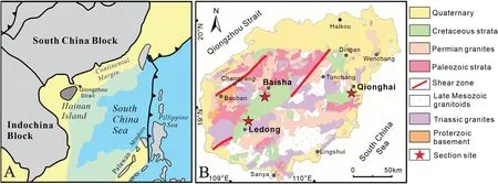
Fig.1 Hainan Island geological map showing the sedimentological and geochemical study locations.A)Regional tectonic map of the SE Asia(modified from Shao et al., 2015); B) Simplified geological map of Hainan Island (modified from Wang et al., 2012 and Chen et al., 2022)showing the Cretaceous clastic sedimentary basins and sampling locations (the red stars).
The significance of sedimentary geochemistry in investigating the sedimentary provenance, source weathering and tectonic setting has been fully confirmed in the literature (Bhatia, 1983, 1985;Bhatia and Crook, 1986; Hossain et al., 2010). Mafic dykes are a common expression of mantle-derived magma generation (Rock, 1991), and geochemical studies of them can provide information regarding the chemical characteristics of mantle sources and the tectonic history of extensional areas (Zou et al.,2000; Cao et al., 2009). In this paper, we present sedimentological, petrological, and geochemical analyses for clastic sedimentary rocks in the Lumuwan Formation and coeval intruded mafic dykes.Based on newly published geochronological results from Lumuwan Formation and dykes (Chen et al., 2022;Dilek and Tang 2021; Meng et al., 2022), our results constrain the tectonic regime of the Hainan basins under a robust age control.The tectonic setting with robust age further supports geodynamic interpretations for the models of South China “Basin and Igneous Province”.
2. Geological setting
The SCB consists of the Yangtze Block in the northwest and the Cathaysia Block in the southeast(Fig.1A,Wang et al., 2012). Multiple stages of subduction and roll-back of oceanic slab triggered large-scale magmatism (Zhou and Li, 2000; Zhou et al., 2006; Liu et al.,2020a)and led to significant subsidence of continental crust,as expressed by the widely distributed magmatic rocks, sedimentary basins and dome structures (Gilder et al., 1991; Shu et al., 2007, 2009; Li et al., 2012;Chen et al., 2022). Cretaceous intrusive rocks in SE China are dominantly high-K,I-type and A-type granites and formed in four major episodes: 146-136 Ma, 129-122 Ma,109-101 Ma and 97-87 Ma(Li,2000;Liu et al.,2020a). Associated with a subduction of the paleo-Pacific plate, Cretaceous extension produced the Southeast China Basin and Range Province (Gilder et al., 1991), and its NE-trending red bed basins were controlled by rifting in relation to the geodynamics of the Late Mesozoic tectonism and granitic magmatism(Shu et al., 2009). Cretaceous basins situated in SE China mainly trend in the NE-NNE direction for more than 1000 km and are parallel to the western Pacific margin(Shu et al.,2007,2009)(Shu et al.,2007,2009).These basins formed the basis of the spectacular Danxia landscapes of the South China.
The Hainan Island is separated from the SCB by the Qiongzhou Strait and is located on the northern margin of the South China Sea(Fig.1A).The Island shows high mountains in the center and lowlands at the margin.NE-trending shear zones with greenschist-to amphibolite-facies metamorphism dominated the island(Zhang et al., 2011). These faults were interpreted based on Carboniferous bimodal volcanics and molasse(Xia et al., 1991; Fang et al., 1992) and mid-ocean ridge basalts (MORB) dated by Sm-Nd at 333 ± 12 Ma(Li et al., 2002). The Proterozoic basement contains amphibolite facies gneissic granitoids and minor metasediments and metavolcanics of the Baoban Group(Zhang et al., 1990; Yan et al., 2017). Palaeozoic to Mesozoic sequences comprise marine carbonates and continental clastic rocks (Wang et al., 1992). Granitic rocks occupy~40%area of the island(Yan et al.,2017)(Fig.1B).Cretaceous granitoids and volcanic outcrops are much less common than those on the mainland of South China(Jiang et al.,2015).The mafic dykes that intruded into Lumuwan Formation/granitoids is dated as 108-93 Ma in Qionghai (~104.6 Ma, Meng et al.,2022), Sanya (93 Ma, Dilek & Tang, 2021), and Tunchang(~107.6 Ma, Wang et al., 2012).
NE-NEE trending sedimentary basins of Cretaceous are widespread in Baisha-Ledong,Dingan and Qionghai regions in the Hainan Island (Fig. 1B). The Lumuwan Formation consists of lacustrine-fluvial grey-purple sandstones and conglomerates with intercalated mudstones, tuffs and marls (Fig. 2). The Lumuwan Formation unconformably overlies the Ordovician strata or Permian-Triassic granitoids regionally.Based on the U-Pb zircon dating of intercalated tuff in the Lumuwan Formation, Meng et al. (2022) defined the age of the Lumuwan Formation as 106.6 ± 0.3 Ma,which is consistent with the youngest detrital zircons age (Chen et al., 2022; Jiang et al., 2015) and ostracoda and charophyte fossils studies (Zhang et al.,1992). The tilting age of the Cretaceous Lumuwan Formation was precisely defined as after the depositional age of 106.6±0.3 Ma and before dyke intrusion at 104.6 ± 0.7 Ma by palaeomagnetism and geochronology (Meng et al.,2022).
3. Methodology
We collected 14 sandstones of Lumuwan Formation red beds from Ledong, Baisha, Qionghai sections, and 11 mafic samples from Qionghai section. All samples were analyzed for petrography and whole rock geochemistry. Whole-rock samples were trimmed to remove altered surfaces, cleaned with deionized water, crushed, and powdered in an agate mill.Major oxides and trace elements data were measured at Beijing Createch Testing Technology Co., Ltd., China.Major elements were determined using Shimadzu X-ray fluorescence (XRF-1800) on fused glass beads. The analytical uncertainties are better than 5% based on the certified standards GSR-4(quartz sandstone),GSR-6 (argillaceous limestone), and GSR-1(granite). Trace elements were determined by inductively coupled plasma mass spectrometry (ICP-MS) using an Analytik Jena PQ Elite instrument.Samples were digested using a mixture of ultra-pure HF and HNO3in Teflon bombs.Analytical procedures were described in detail by Chu et al. (2009). Three Chinese national standards (GSR-1,GSR-4 and GSR-6)were used to check the accuracy,which is generally better than 5% for most trace elements in this study. Whole-rock major and trace element compositions of samples are given in Table S1.
4. Sedimentology
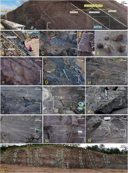
Fig.3 Outcrop photographs of sedimentary structures in the Lumuwan Formation and Cretaceous dykes.A-B)A classic“lacustrine sandwich”of Lumuwan Formation in Ledong section with a lower/upper coarse-grained fluvial sandstone intercalated by fine-grained laminated dark gray lacustrine marl in Ledong; C-D) Ripples in marl and sandstone; E) Nodules in marl; F) Planar cross beddings and parallel beddings; G)Horizontal beddings; H) Parallel beddings; I-J) Horizontally stratified, imbricated conglomerates; K) Conglomerate beds contain abundant reworked sedimentary clasts;L)Trough cross-stratification;M-N)Planar cross-stratification;O)The intruded NE-trending Cretaceous diabase dykes along joints NE-strike sinistral slip faults into Lumuwan Formation in Qionghai section.
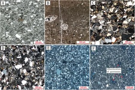
Fig.4 Plane-polarized light photomicrographs of tuff,marl,sandstones and diabase dyke from the Lumuwan Formation.A)Tuff sample from Ledong section; B) Bioclasts marl from Ledong section; C-E) Fine-medium grained sandstone from Ledong (C), Qionghai (D) and Baisha (E)sections respectively; F) Diabase sample from Qionghai section showing porphyritic structure and ophitic texture.
Cretaceous strata of the Lumuwan Formation crop out extensively in Hainan Island with a variable thickness ranging from <100 m to >1000 m (Fig. 1B). Depositional environments in the Lumuwan Formation are reconstructed on the basis of sedimentological observations documented in ~900 m of measured stratigraphic sections in Ledong,Qionghai and Baisha(Fig.2).Fluvial and lacustrine facies developed during the deposition of the Lumuwan Formation according to lithology assemblages and sedimentary characteristics.
The Ledong section shows an upward-fining trend of pebble sandstones, mudstone, laminated marl(interbeded nodules in some layers,Fig.3E)with a thin crystal tuff bed in the middle part(Fig.4A).The lowermiddle part of the Ledong section consists of marls,green siltstone and silty mudstone with ripple marks(Fig. 3C). Sandstone beds are topped by small symmetrical ripples (Fig. 3D). Pebbly coarse-grained sandstone beds show imbricated pebbles, parallel beddings and planar cross beddings(Fig.3F).Marl beds show horizontal lamination (Fig. 3G). The red sandstone beds are fluvial channel deposits; and the laminated marls are lacustrine deposits. The marls are composed of cryptocrystalline or microcrystalline calcite and siliciclastic detritus of pelitic dimension,and contain bioclasts(Fig.4B).The Ledong Basin shows a distinct transition of depositional systems from a lower fluvial system to medial lacustrine system and upper fluvial system. This assemblage of lithologies suggests deposition in a mixed fluvio-lacustrine system that experienced seasonal, semiarid climate. It resembles a classic“lacustrine sandwich”(Fig.3A-B)in a rift basin with a lower coarse-grained interval overlain by fine-grained lacustrine deposits, which are in turn overlain by a return to relatively coarse-grained fluvial deposits (DeCells et al., 2011).
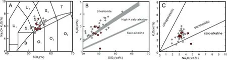
Fig. 5 A) Na2O + K2O versus SiO2 (wt%) diagram (S1-trachybasalt, S2-basaltic trachyandesite, S3-trachyandesite, T-trachyte, U1-basanite,U2-phonotephrite, B-basalt, O1-andesite basalt, O2-andesite, O3-dacite) (Le Bas et al., 1986; Irvine and Baragar, 1971); B) SiO2 versus K2O(wt%)diagrams(Morrison,1980);C)Na2O versus K2O(wt%)diagrams(Peccerillo and Taylor,1976).The red dots are diabase data for this study;the grey rhombuses are data for 136-93 Ma mafic dykes in central and south Hainan Island from Ge (2003).
The lower member of the Lumuwan Formation in Qionghai and Baisha sections is composed of lower pebble-cobble conglomerate and upper sandstone with several conglomerate interbeds, showing an overall upward-fining sequence (Fig. 2). In Baisha section, the Lumuwan Formation rests unconformably on the granitoids and is internally conformable(Fig.2).Dominant lithologies include clast-supported,horizontally stratified,well-organized,and imbricated pebble-cobble conglomerate in beds that range from a few tens of centimeters to several meters thick(Fig. 3I-K). Conglomerates have average maximum clast sizes of 5*7 cm and are dominated by volcanic,granitoid, and red beds clasts (Fig. 3I). Some conglomerate beds contain abundant reworked sedimentary clasts (Fig. 3K). Pebbly sandstones with extensive parallel bedding (Fig. 3H), planar cross beddings (Fig. 3M-N) and trough cross beddings(Fig.3L).Qionghai section shows a typical sequence of small braided fluvial channels that debouched into local lacustrine environments:(1)a series of beds with slightly erosional basal surfaces and finer-grained upper parts, changing from >10 cm-thick conglomerate to centimeter-scale layers of fine-medium sandstone (Fig. 2); (2) the upward changes of sedimentary structures from parallel beddings within conglomerate to trough and planar cross beddings(and parallel beddings)within the upper sandstone(Fig.3).
5. Microscopy and geochemistry
The sandstones are fine-to medium-grained and gray-purple or gray-green in color. Thin section observation reveals that they were mainly lithic arkoses or feldspathic litharenites (Fig. 4C-E). The sandstones are submature in general, moderately sorted and sometimes are cemented by calcite. The quartz grains are mainly monocrystalline, with a content of 25%-47%.The content of feldspar is 31%-43%,microcline, plagioclase, perthite and orthoclase feldspars are all common.The lithic grains(~20%)include sedimentary rock fragments, metamorphic rock fragments and volcanic fragments, also containing considerable chert,polycrystalline quartz and biotite.Modal petrographic data plotted on standard Ternary diagrams(Dickinson,1985)of those sandstones show a magmatic arc provenance (Chen et al., 2022).
A number of diabase dykes emplace in the Lumuwan Formation along high-angle normal faults at Qionghai section (Fig. 3O). The diabase samples are dark green, fine-grained, relatively fresh, and show porphyritic structure and ophitic textures (Fig. 4F).Plagioclase (~70%) and clinopyroxene (~30%) are the main minerals. Plagioclase is needle-like, with weak sericitization.Clinopyroxene is granulous,chloritized,and comes in two groups of sizes. A number of chloritized clinopyroxene phenocrysts show abnormal interference color of blue. The petrographic observation of diabase in the thin section illustrates that most of them didn't suffer significant alteration.
The SiO2content of Qionghai mafic dykes ranges from 49.2 wt% to 51.7 wt%, with basaltic characteristics (Fig. 5A). They generally show relatively low TiO2(0.90-0.93 wt%), high Al2O3(14.9-15.6 wt%), K2O(1.2-2.8 wt%, Av. 2.31 wt%) and K2O/Na2O(0.26-0.91 wt%, Av. 0.74 wt%) values, and plot in the field of high-K to shoshonites magmatic rocks (Fig. 5B and C).The MgO ranges from 6.3 to 8.23 wt%,and Mg#value (100 × [atomic MgO/(MgO + FeO)]) ranges from 65.3 to 67.6. The loss on ignition (LOI) is low(0.63-0.74 wt%). The dykes have uniform total rare earth element (REE) (ΣREE = 152.5-189.6 ppm) and are characterized by enriched light REEs ([La/Yb]N= 13.0-16.5), relative flat heavy REEs ([Gd/Yb]N=2.72-3.39)(Fig.6A),and negative Eu anomalies(δEu = 0.75-0.82). They are depleted in high field strength elements(HFSEs),such as Nb,Ta,and Ti,and enriched in large-ion lithophile element (LILEs), such as Ba, Sr, Rb, Th, U, Pb, Cs (Fig. 6B).
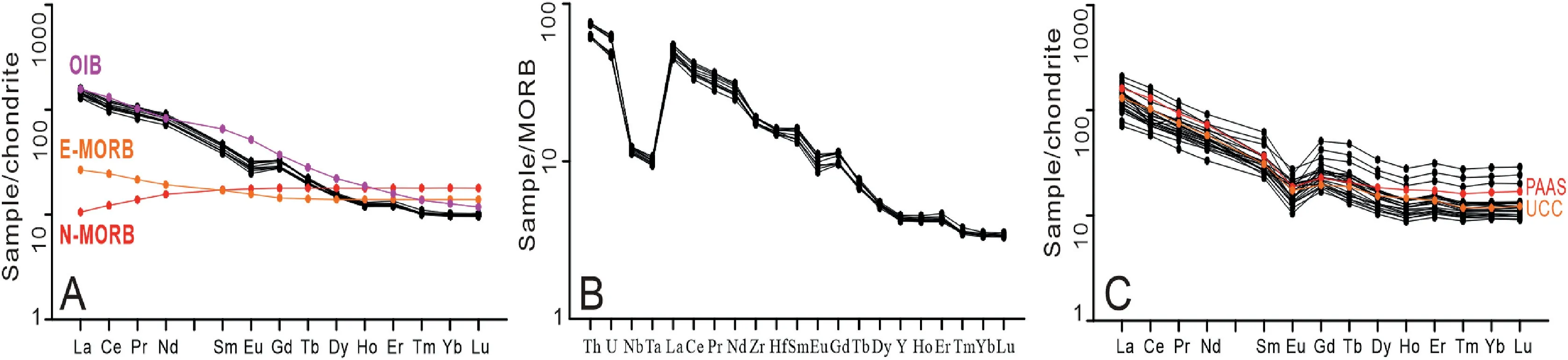
Fig. 6 A) Chondrite-normalized REE patterns and B) Primitive mantle-normalized multielement patterns of diabase dykes in Qionghai section;C) Chondrite-normalized REE patterns of the sandstones from Lumuwan Formation. Chondrite values are from Sun and McDonough(1989). OIB: ocean island basalts, E-MORB: enriched mid-ocean ridge basalt, N-MORB: normal mid-ocean ridge basalt, UCC: Upper Continental Crust, PAAS: Post Archaean Australian Shale composite.
The Lumuwan sandstones from Ledong and Qionghai sections have SiO2content ranging from 54.99 to 79.56 wt. %, and high Al2O3(10.94-16.0 1wt. %), K2O(2.71-4.60 wt. %) and Na2O (0.99-3.20 wt. %) contents, and low Total Fe2O3(1.6-5.8 wt. %) and MgO(0.52-2.54 wt. %) contents. Major and trace element compositions of the sandstones are compared with the compositions of the Post Archaean Australian Shale composite(PAAS;Taylor and McLennan,1985)and the average Upper Continental Crust(UCC;Rudnick et al.,2003)(Fig.7).Except CaO and MnO,the abundances of other major elements are generally similar to the corresponding abundances in PAAS and UCC(Fig. 7A-B). The trace element abundances of the sandstones are comparable to PAAS and UCC(Fig. 7C-D), showing slight depletions in the LILE Sr,Ba, and the ferromagnesian trace elements Cr, Co, Ni and Cu, and showing relative enrichment in high-field strength elements Th. The REE data of sandstones are relatively consistent (Fig. 6C). The total REE contents range from 87.19 ×10⁻⁶to 248.03 ×10⁻⁶,with a mean value of 143.97×10⁻⁶,which are similar to UCC and lower than PAAS. The sandstones are characterized by enriched light rare earth elements(LREE),and high ratios of La/Yb=8.78-23.40(Av.14.59),(La/Yb)N = 6.30-11.00 (Av. 8.60) and ∑LREE/∑HREE = 5.78-7.59 (Av. 6.75). They show a negative Eu anomaly (δEu = Eu/Eu*) ranging from 0.37 to 0.83(Av. 0.58). Heavy rare earth elements (HREE) show relatively flat distribution, with (Gd/Yb)N ratios ranging from 1.73 to 2.27 (Av.1.96).
6. Discussion
6.1. Petrogenesis of the mafic dykes and tectonic implications

Fig. 7 PAAS- and UCC-normalized major and trace element diagrams for the sandstones from mid-Cretaceous Lumuwan Formation, Hainan Basin (PAAS data from Taylor and McLennan, 1985, UCC data from Rudnick and Gao, 2003).
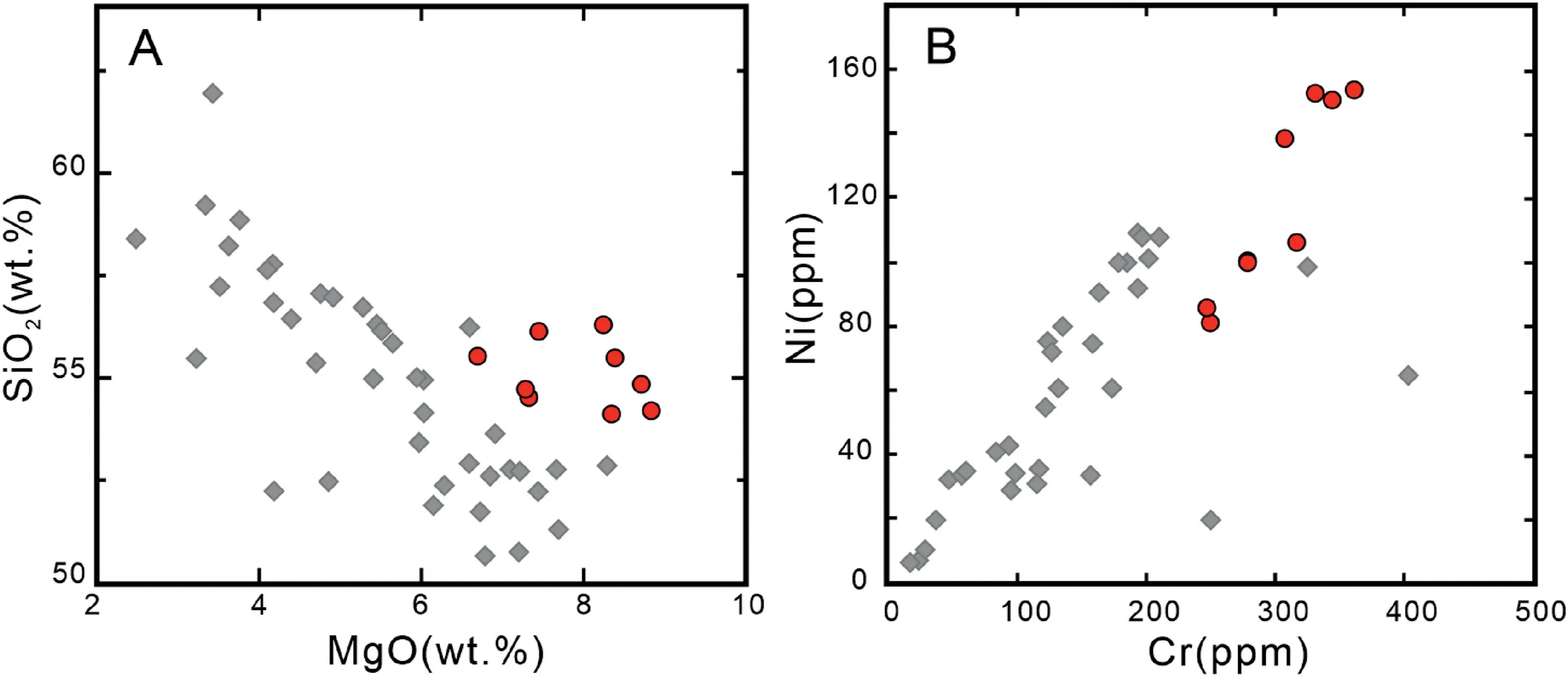
Fig.8 Variation diagrams for SiO2 versus MgO and Ni versus Cr contents for mafic dykes from Qionghai section.The red dots are data from this study (~104.6 Ma); the grey rhombuses are data from the 136-81 Ma mafic dykes in central and south Hainan Island from Ge (2003).
Crustal assimilation is almost inevitable for mantle-derived melts during their ascent through the continental crust or their evolution within a crustal magma chamber (e.g., Wilson, 1989; Castillo et al.,1999). In Qionghai section, the studied mafic dykes intruded wall rock sandstones along joints/faults with a clear and smooth contact (Fig. 3O), suggesting no significant upper crustal contamination because of fasting rise. This is also supported by the previous Sr-Nd isotope study on the Cretaceous mafic dykes from central Hainan (Ge, 2003), which showed a high initial87Sr/86Sr ratio (0.7065-0.7195), low εNd(t)value (-8.8-0.1), and no correlation between Sr-Nd isotopic composition and SiO2/MgO, as well as εNd(t)and Nb/Th values. High MgO and low SiO2values suggest mafic dykes in Hainan are relatively primitive(Fig. 8A), but probably experienced clinopyroxene and/or combined olivine and spinel fractionation as shown in well positive correlation between Cr and Ni(Fig. 8B) (Pf¨ander et al., 2002).
Diabase dykes in Qionghai section show a typical“subduction component” characteristic (Pearce and Peate, 1995): significant enrichments of LILE (e.g.,Ba, Sr, Rb, Th, U, Pb, Cs) and LREE, depletions of the HFSE Nb, Ta, and Ti (Fig. 6A-B), suggesting a shared magma source region that possibly formed in a close relation with dehydration processes in the subduction zone. This is confirmed by major and trace element diagrams (Figs. 9 and 10). The compositional fields of Qionghai diabase dykes overlap those of Cenozoic Roman (ROM)-type potassic mafic lavas (Mg#>0.60)(Fig. 9A) in Italy (Peccerillo, 1999). The ROM-type potassic mafic rocks are considered to have been derived from a restitic lithosperic mantle and fertile asthenospheric sources metasomatized by the introduction of a component like deeply subducted upper crustal material (Peccerillo, 1999). In the Fe2O3vs.TiO2diagram (Fig. 9B), the compositional fields of Qionghai diabase dykes are plotted between the fields of fertile and depleted peridotite melts.The high Nb/Ta ratios (Fig. 9C) suggest that the mantle sources of those diabase dykes were metasomatized by silicic melts from subducted oceanic crust or sediments(Stolz et al., 1996; Peccerillo, 1999). In the La/Yb vs.Th/Ta cross-plot(Fig.10A),the samples also plot in the field of subduction zone basalts rather than oceanic plateau basalts (OPB) or mid-oceanic ridge basalts(MORB). In the Nb/Th vs. Zr/Nb plot (Fig. 10B), the data are close to the end member components of upper continental crust (UCC) and enriched mantle(EN) rather than depleted mantle (DEP) or recycled slab (REC) (Condie et al., 2002). Together with the relatively low U/Th and Sm/La ratios and high Th and Th/La values (Fig. 10C-D, Hawkesworth et al., 1997;Plank, 2005, Wang et al., 2012), the major and trace element concentrations suggest that Qionghai diabase dykes are sourced from asthenospheric and lithospheric mantle,and then metasomatized by subducted oceanic crust.
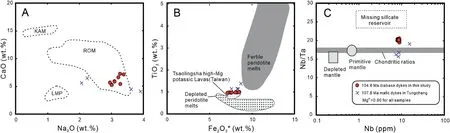
Fig.9 A-B)Petrological variations of mafic rocks in Hainan Island;C)Nb versus Nb/Ta plot.The data of 107.6 Ma mafic dykes in Tunchang are from Wang et al. (2012). The fields for Cenozoic KAM (kamafugitic rocks), LAM (Roman-type rocks) and ROM (lamproitic rock) type mafic(Mg#>0.60) potassic rocks in Italy are after Peccerillo (1999). The fields for fertile and depleted peridotite melt and subducted fluidmetasomatized harzburgitic source (lithospheric mantle)-derived Tsaolingshan high-Mg potassic Lavas in Taiwan are after Chung et al.(2001). The field for primitive and depleted mantles, chondrite and missing silicate reservoir are from Barth et al. (2000).
The Okinawa Trough, a young back arc basin formed by the extension of Asian continental lithosphere behind the Ryukyu arc-trench system, represents one of the active back arc rifts in the western Pacific(Shinjo,1999).Revealed by Ba/Nb,Th/La,Rb/Zr, and La/Nb ratios (Fig. 11), NE striking mid-Cretaceous mafic dyke swarms (~108-93 Ma) in Hainan (Qionghai, Tunchang, Dongfang, Sanya,Changchang) (this study, Ge 2003; Wang et al., 2012;Dilek and Tang, 2021; Meng et al., 2022) collectively exhibit a spectrum of compositional features similar to the Okinawa intracontinental back arc basin basalt(BABB), which is a mixture of MORB-like and arc volcanic-like components erupted in a continental basement. These dykes were intruded along NE-SWoriented fault/joint systems. Widespread NE-SW dyking event (~108-93 Ma) in a regional suggested the NW-SE-oriented extensional stress regime. Initial87Sr/86Sr vs143Nd/144Nd isotopic values for the Cretaceous dyke intrusions show a time progressive evolution of melt sources from a sub-arc type mantle field(Dilek and Tang, 2021). The Palaeo-Pacific magmatic arc was the apparently continuous plutonic province along the Southeast Coast Magmatic Belt of China into southern Vietnam and Borneo (Morley, 2012; Yuan et al., 2019). Metasomatized asthenospheric and lithosperic mantle sources and back-arc tectonic setting suggest that Hainan mafic dykes were probably formed by the extension of Asian continental lithosphere during the subduction of the Palaeo-Pacific plate beneath the SCB.
6.2. Tectonic setting of Hainan Island during mid-Cretaceous
The mid-Cretaceous Hainan basin trends parallel to the sinistral NE-trending shear zone and the regional trend of Palaeo-pacific subduction zone. Fang (2016)concluded that the Lumuwan Formation was deposited in response to the regional uplift of the Hainan Island in an overall contractional tectonic setting associated with the Neo-Tethyan subduction (Sun,2016; Sun et al., 2017). Our results instead suggest the deposition in a rift basin.The key observations that do not support deposition in a contractional setting are as follows. (1) Combining the features of REE-related parameters (La, Ce, ∑REE, La/Yb, LaN/YbN,∑LREE/∑HREE, Eu/Eu*; Table 1, Bhatia, 1985),geochemistry data (Fig. 12) show a significant similarity with CIA group and suggest the Lumuwan Formation was accumulated in an intracontinental backarc extensional basin during mid-Cretaceous in Hainan Island. An overall extensional setting is consistent with the presence of coeval bimodal volcanics (c.a. ~102 Ma) in southern Hainan Island (Zhou et al., 2015). (2) The Lumuwan strata are mostly tilted toward the NW with decreasing dip angle controlled by listric fault in the Fuwen ore deposit(Xu et al., 2017). We found no evidence for progressive tilting of bedding characterizing contractional growth structures in the Lumuwan Formation. (3) The overall textural and lithology pattern in the Lumuwan Formation is not an upward-coarsening sequence of growth strata which is typical of contractional wedge top settings or proximal foredeep settings (DeCells et al., 2011). Instead, the Lumuwan Formation generally fines upward and consists of a classic riftbasin lacustrine sandwich, which is most consistent with deposition in an extensional or transtensional rift basin like the Kailas basin in southwestern Tibet(DeCelles et al., 2011).
Extension of the South China lithosphere during mid-Cretaceous time is supported by recent work by Xu et al. (2021), who studied the kinematic analysis for coeval fault-slip data and documented a NW-SE horizontal minimum principal stress and a vertical maximum principal stress that activated the NEstriking boundary normal faults of mid-Cretaceous basins. NE-trending sinistral shear faults bound the Cretaceous basins at Baisha, Ledong, Dingan, and Qionghai (Wang et al., 1991; Metcalfe, 1994; Zhang et al., 2011). Zhang et al. (2011) reported kinematic indicators that document the Gezhen fault near Changjiang in NW Hainan, which might have experienced reactivation as brittle shearing during mid-Cretaceous (Zhang et al., 2011; Xu et al., 2017) and provide a ready explanation for the presence of extensional basin deposits in the Lumuwan Formation.This is consistent with four stages of shear deformation dating at ca. 295 Ma, ca. 250-240 Ma, ca. 230-190 Ma and ca.115-80 Ma(HBG,2016)for the development of the NE-trending shear zones.Coupled with a synthesis of thermochronologic data near NE-trending faults facilitating the opening of the Cretaceous extensional basins (e.g., Jianghan, Nanxiong, Boyang, Henyang,etc.), this would reveal a prominent, rapid cooling event and NE-trending syn-sedimentary faults with half-/graben basins in a back-arc extension setting at~125-95 Ma (Wang et al., 2020).
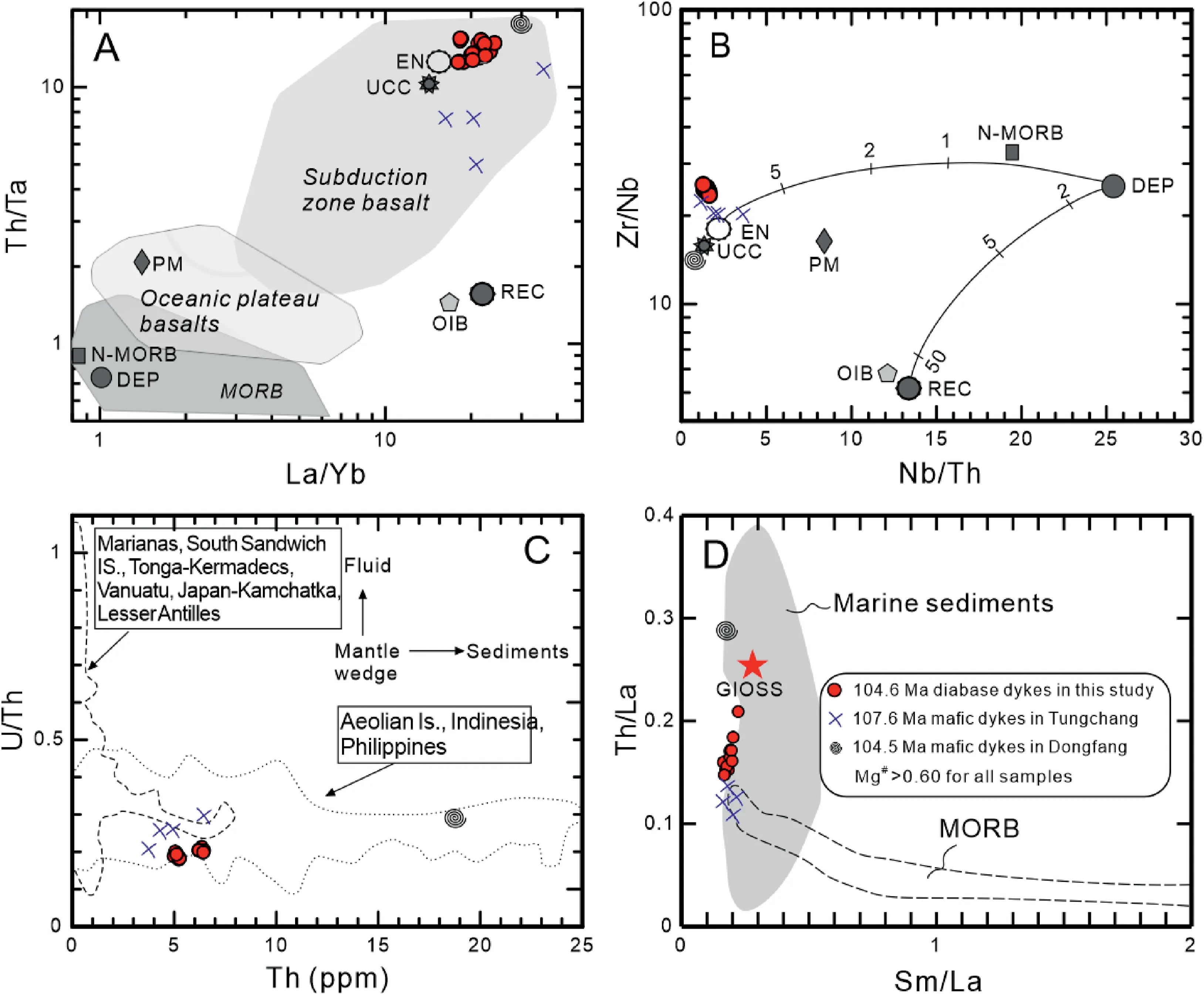
Fig.10 A)La/Yb versus Th/Ta,B)Nb/Th versus Zr/Nb,C)Th versus U/Th,and D)Sm/La versus Th/La diagrams for Hainan Cretaceous mafic dykes. The red dots are the data from Qionghai diabase dykes (~104.6 Ma) in this study. The data of ~107.6 Ma mafic dykes in Tunchang are from Wang et al.(2012).The fields for DEP(depleted mantle),EN(enriched mantle),MORB(middle oceanic ridge basalts),N-MORB(normal MORB), OIB (oceanic island basalts), PM (primitive mantle), REC (recycled slab component) and UCC (upper continental crust) are after Condie et al.(2002).The field for MORB is after Plank(2005).The data for marine sediments and GLOSS(global subducted sediments,the red star) are from Plank and Langmuir (1998).
The timing of crustal extension in South China margin initiated at ~136 Ma (Li et al., 2014; Dong et al., 2015) and continued during ~108-93 Ma dated by the Hainan back-arc rifting basin (~107 Ma), mafic dykes (~108-93 Ma), bimodal volcanics (~102 Ma). According to the Palaeo-stress study, Chan et al. (2010)determined the extension direction during the Late Mesozoic was primarily in a NW-SE direction, which agrees with the NE trend of Hainan basin. Thus, our study supported the tectonic scenario of sinistral strike-slip faulting and rifting driven by a northwesterly oblique component of the subduction (Gilder et al., 1996) for the SCB. It would better explain the broader distribution of Cretaceous basins in South China, which is largely responsible for the development of the South China basin-and-range (Gilder et al.,1996;Li et al.,2014;Ji et al.,2017,2018a,b).

Fig. 11 A) Ba/Nb versus Nb/U, B) Th/La versus Ce/Pb, C) Rb/Zr versus Nb/La (Shinjo, 1999), and D) Y versus La/Nb (Floyd et al., 1991)diagrams for the mafic dykes in Hainan. The red dots are the data from Qionghai section in this study. The data of 105-107 Ma mafic dykes(blue dots)are from Wang et al.(2012).Representative basalts from oceanic tectonic settings(OIB,E-MORB,and N-MORB)shown are from Sun and McDonough (1989). Values for upper continental crust (UCC) is from Taylor and McLennan (1985) with revision of Plank and Langrnuir(1998). Global subducting sediment (GLOSS) is from Plank and Langrnuir (1998).

Table 1 REE characteristics for tectonic setting discrimination of margin and ratios for sandstones from Lumuwan Formation(after Bhatia,1983).
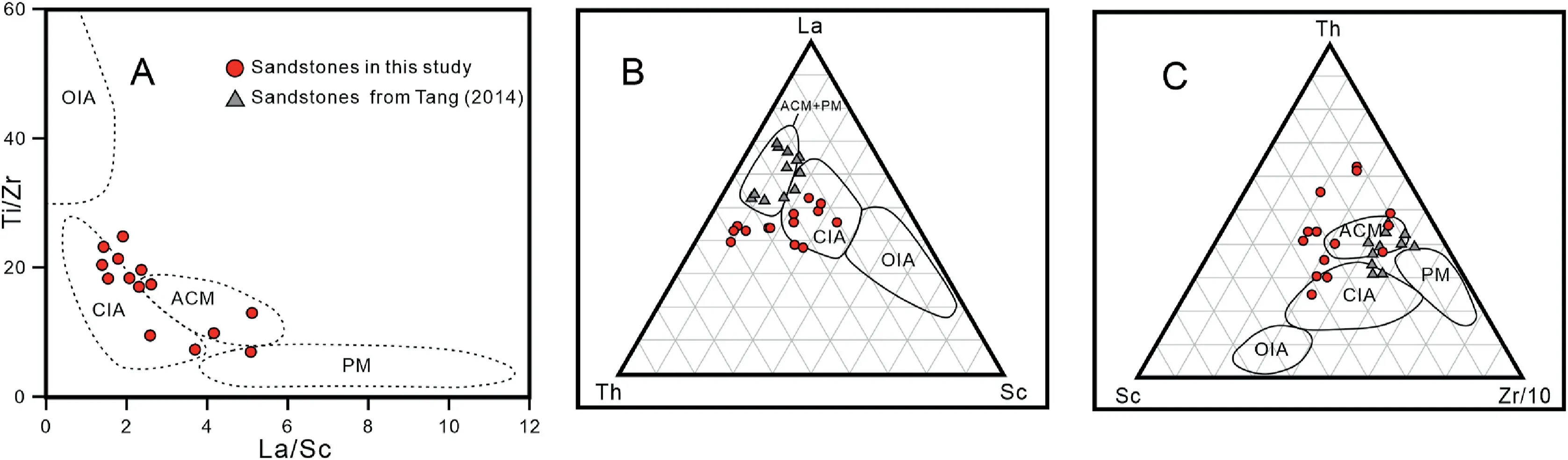
Fig. 12 A) Ti/Zr versus La/Sc, B) La-Th-Sc and C) Th-Sc-Zr/10 plots of sandstones for tectonic setting discrimination (Bhatia and Crook,1986). Fields and symbols are: OIA = oceanic island arc; CIA = continental island arc; ACM = active continental margin; PM = passive margin.The red dots are the sandstone data in this study.The grey triangles are sandstones data from the Lumuwan Formation in Ledong area from Tang (2014).
7. Conclusions
1) Braided fluvial and restricted lacustrine deposits constitute the late Early Cretaceous Lumuwan Formation in Hainan Island.
2) Geochemical data, along with petrographic textures show that ~105 Ma Qionghai mafic dykes in Hainan Island are likely to be originated from asthenospheric and lithosperic mantle sources.These were metasomatized by subducted oceanic sediments in a back-arc setting, formed by extension of continental lithosphere.
3) We propose that the bulk of the Lumuwan Formation was deposited in a basin produced by back-arc extension. The timing of crustal extension in the South China margin was constrained during ~108-93 Ma. The extension played a significant role in Basin and Range-Type tectonics and landscape evolution in South China.
Availability of data and materials
Datasets for this research are available in the supplementary materials.
Conflicts of interest
The authors declare that they have no known competing financial interests or personal relationships that could have appeared to influence the work reported in this paper.
Funding
This research was financially supported by National Natural Science Foundation of China (41888101,91955206,41974072,41676050),Ministry of Education of the People's Republic of China (Fundamental Research Funds for the Central Universities:2652021006, 2652017205, 2652018124, 2652019177).
杂志排行
Journal of Palaeogeography的其它文章
- 150 Years (1872-2022) of research on deep-water processes, deposits, settings,triggers,and deformation:A difficult domain of progress, dichotomy, diversion, omission, and groupthink
- The control of Pleistocene palaeogeography on the distribution of sandy patches in a silty Holocene lagoon (central Netherlands)
- Application of remote sensing in the description of fluvial system in dryland: A case study of Golmud distributive fluvial system,Qaidam Basin, NW China
- Sedimentology and foraminiferal paleoecology of the exposed Oligocene-Miocene Ogwashi-Asaba Formation in Issele-Uku area, Anambra Basin, southern Nigeria: A paleoenvironmental reconstruction
- A new oospecies of Shixingoolithus(Shixingoolithus qianshanensis oosp. nov.)from the Qianshan Basin, Anhui Province, East China
- Scales in the Early Cretaceous bird Gansus from China provide evidence on the evolution of avian scales