The control of Pleistocene palaeogeography on the distribution of sandy patches in a silty Holocene lagoon (central Netherlands)
2022-11-24AiPingFnTomvnLoonRenChoYng
Ai-Ping Fn , A.J. (Tom) vn Loon ,*, Ren-Cho Yng ,b
a College of Earth Science and Engineering,Shandong University of Science and Technology,Qingdao,China
b Laboratory for Marine Mineral Resources, Qingdao National Laboratory for Marine Science and Technology,Qingdao 266071, China
Abstract The brackish lagoon in the central part of The Netherlands was closed by a dike in 1932 and gradually changed into a lake. Parts of this lake were reclaimed and the surficial sediments of one of the polders(Noordoostpolder),reclaimed in 1942,has been investigated in detail by mapping of the walls of some 1500 km of drainage ditches approx. 1.4 m deep. It appeared that the sediments consist of an uncommonly large amount of silt, to different degrees mixed with reworked peat that had developed during the Holocene transgression. Some sandy deposits occur locally, at places that are at first sight distributed in a haphazard way. The various sandy patches have different characteristics (grain-size distribution, rounding of the grains,mineral composition).These sands cannot have been introduced from the sea,nor can they have been supplied by the rivers that discharged into the lagoon,so they must have a local origin.It is found that several types of Pleistocene sandy or diamictic deposits below the Holocene peat and lagoonal sediments had an irregular topography and became eroded during the Holocene by wave activity. This resulted in sandy deposits around these Pleistocene highs,which consisted of glacial tills(boulder clays),river dunes(formed by aeolian activity along rivers under dry permafrost conditions) and coversand ridges, formed by aeolian activity in a belt between the ice margin and the more distal loess belt. This finding implies that palaegeographical interpretations of local grain-size anomalies in a specific deposit should not only consider facies changes due to changes in the sediment supply, but should also consider local erosion leading to the exposure of previously deposited material with a divergent composition.
Keywords Lagoonal palaeogeography, Netherlands, Noordoostpolder, Wave erosion, Abrasion, Holocene
1. Introduction
The centre of The Netherlands was a brackish lagoon, extending from the Dutch Wadden Sea, until 1932, when a dike (the ‘Afsluitdijk’ = Enclosure Dam)was constructed that connected the north-western and central northern parts of the country. The closure implied that the brackish lagoon,called‘Zuiderzee’(=Southern Sea) changed gradually into a lake. The Enclosure Dam not only forms a barrier for sedimentary particles moving from the Wadden Sea to the newly formed lake, or reverse (Colina Alonso et al. (2021)),but also changed the originally brackish lagoon into a fresh-water lake (called ‘IJsselmeer = Lake IJssel),thanks to precipitation and the influx of a relatively large river(IJssel)and some smaller streams.
Several parts of this lake have been reclaimed.After these areas had fallen dry,ditches of some 1-2 m deep were dug for drainage.The sides of these ditches formed extensive,continuous and beautiful exposures of the uppermost beds(mainly Holocene),resulting in many investigations of these deposits. These investigations were so detailed that Kuenen(1959)even spoke of the most extensive research in shallowmarine deposits that has ever been carried out.Indeed,probably no more detailed work has ever been done since in such deposits.
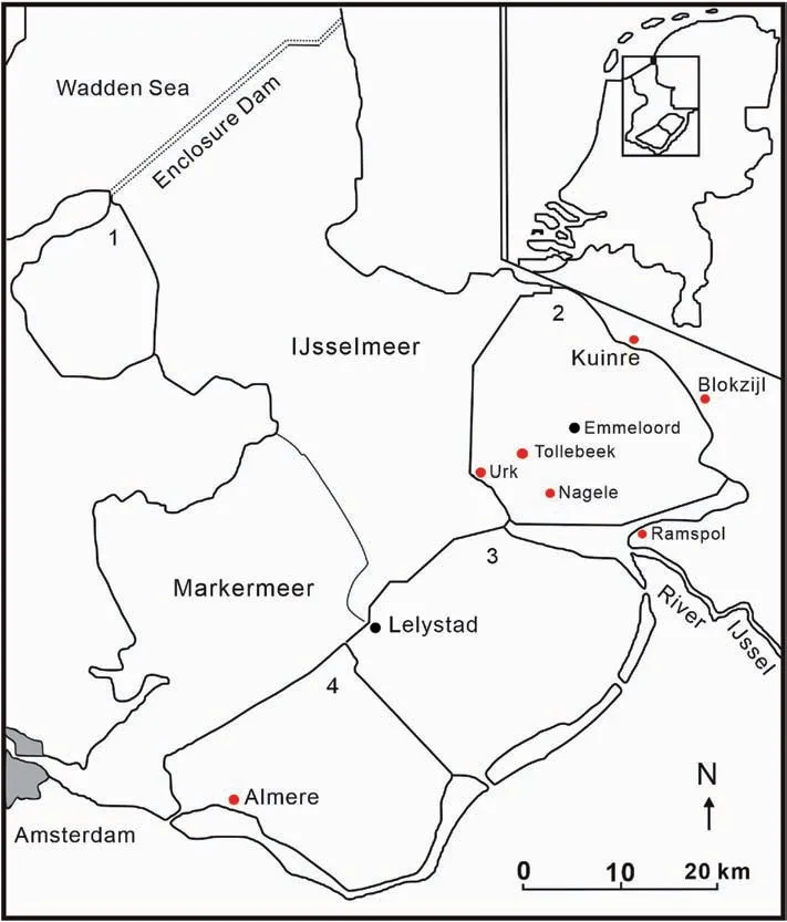
Fig. 1 Location map of the Lake IJssel area with the reclaimed polders (1 = Wieringermeerpolder; 2 = Noordoostpolder; 3 = Oostelijk Flevoland;4=Zuidelijk Flevoland).The locations in the study area(Noordoostpolder)that gave their names to deposits mentioned in the text are indicated by red dots; dark blue dots indicate the main towns of the polders. Inset: Location of Lake IJssel in The Netherlands.
When the successive polders started to fall dry, a wide variety of investigations started immediately.These were aimed primarily at finding out which soil type were present (and where), and in how far the various types would favor specific agricultural activities. This implies that a huge amount of data about salinity, organic content and, particularly, grain-size distribution became available between the 1920s and 1970s, following the schedules and their implementation of the reclaiming activities for the successive polders.Moreover,maps were prepared of the exposed layers in the constructed drainage ditches.These maps cover a total length of over 1500 km,but are not easily accessible. Another disadvantage is that almost all of these reports and publications are in the Dutch language,which hampers use for more advanced studies.Therefore, we mention here only some of the most important original studies.
A study of the soil conditions of the first pilot polder(Andijker Proefpolder) was published by Hissink(1929). This was followed by a similar study for the first ‘real’ polder (Wieringermeerpolder) by Zuur(1936). Comparable studies about the Noordoostpolder (where the sediments under study here are situated)were published by Zuur(1948b,1951,1954),Wiggers (1955) and Wiggers et al. (1962). The soil conditions of Oostelijk Flevoland were dealt with by Zuur(1950),De Koning and Wiggers(1955),Ente et al.(1961)and Koopstra(1961,1962).The soils of the last reclaimed polder (Zuidelijk Flevoland) were analyzed by Zuur (1948a). In addition to these studies, the following more general studies about particularly the grain-size characteristics of the bottom sediments of Lake IJssel are worth mentioning: De Ridder and Wiggers (1959), Pons and Wiggers (1959-1960), Smits and Wiggers (1959) and De Glopper (1973). In addition to our own fieldwork,we have taken advantage of the above-mentioned studies for the present contribution.
1.1. Geographical setting
The present study deals with sandy deposits,embedded in fine-grained(mainly silty)deposits in one of the polders, the Noordoostpolder (North-Eastern Polder). It is one of the four polders that were reclaimed after a small area,the Andijker Proefpolder(Andijk Pilot Polder) had successfully been reclaimed from the Zuiderzee, followed by the Wieringermeerpolder (1930). Both polders indicated that reclamation of larger polders from Lake IJssel was feasible.This led to the successive reclamation of the Noordoostpolder (1942), Oostelijk Flevoland (1957)and Zuidelijk Flevoland(1968)(Fig.1).
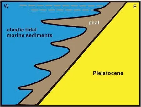
Fig.2 Simplified cross-section(not to scale)through the study area to show the essential principle of the stratigraphic context of the sedimentary development in the study area during the Holocene sea-level rise. The westward inclined Pleistocene surface became covered by a gradually farther eastward extending peat layer that formed in the eastward shifting coastal swampy area. Some small interruptions of the transgression led to minor and discontinuous extensions of the peat(dashed horizons)into the marine sediments in the west.
An envisaged younger polder in the eastern part of Lake IJssel has not been realized because of environmental considerations.A dike had already been constructed, so that a separate lake (Markermeer)originated. This lake is the subject of much research,for instance regarding sediment transport(Kelderman et al.,2012a,b).Unfortunately,the sediments of this lake are hardly investigated themselves,although it is known that they are also fine-grained (Adiyiah et al.,2014; Barciela-Rial et al., 2020) and that they are easily eroded(De Lucas De Lucas Pardo et al.,2013),so that resuspension is common (De Rozari, 2009). Most interest is paid nowadays to some artificial islands constructed in this lake, where pioneer vegetation settles (Saaltink et al., 2018) and beaches develop(Ton et al., 2020).
1.2. Geological setting
Regarding the Noordoostpolder, which is the subject of the present study, it is known from previous studies(e.g.,Wiggers,1955;Wiggers et al.,1962;Van Loon and Wiggers,1975a,b)that the sediments in the Noordoostpolder have an uncommon grain-size distribution (Zuur, 1943), particularly regarding the sediments that were deposited between 0 and 1600 A.D.These deposits, originally called ‘sloef’ (after the German word ‘Schluff’ for sediments that are susceptible to thixotropy due to a high silt content) have a silt/clay ratio of roughly 3:1, whereas this ratio for marine sediments tends to be 1:3.The non-continental Holocene sediments in The Netherlands have been assigned to the Groningen Formation by Roeleveld(1974); Van Loon and Wiggers (1975c) defined the silty lagoonal sediments in the Noordoostpolder to the Almere Member of the Groningen Formation. The Geological Survey of The Netherlands later assigned them to the Westland Formation(Doppert et al.,1975)and now assigns these sediments to the Naaldwijk Formation (Weerts et al., 2000).
Considering the changing and somewhat confusing stratigraphical names, it seems sufficient to provide here only a schematic sketch of the Holocene sedimentation in the Noordoostpolder.The Holocene rests upon the Pleistocene (mainly Weichselian coversands with some river dunes along the braided-river systems,and locally Saalian glacial diamicts), which dips slightly to the south-west.During the post-glacial sealevel rise, a Holocene peat developed in the marshy area along the coast, younging to the east, in which direction it is also located at gradually higher positions, due to the ongoing transgression (Fig. 2). A further transgression partly covered this peat with a layer of clay,called“Unioklei”(clay with bivalve shells of Unio timidus),with a lagoonal facies.The overlying peat layer, still present in some places, was dated at 4630±90 B P(Ente,1971).During the deposition of the clay,parts of the peat were eroded,resulting in a layer(the older of the two) of detritus-gyttja.
Subsequently,clay sedimentation again took place in the western part of the polder. This so-called“Cardiumklei” (clay with bivalve shells of Cardium edule)has been deposited between 3550 and 3150 B P(Wiggers, 1955; Ente et al., 1961). In the north, peat growth continued. However, generally more peat was eroded by wave action in the lakes, which here probably already formed during the beginning of the subboreal. This led to a second layer of detritus-gyttja,the formation of which started at about 1250 B.C.(Ente, 1964) in an area that then was covered by one large lake, mentioned by Roman historians (Lacus Flevo =Lake Flevo).
Some 2000 years ago, the small connection between the Flevomeer and the Waddenzee (Wadden Sea)became wider,resulting in a true lagoon,although the water was mainly fresh to slightly brackish,due to inflow of waters from the rivers(e.g.,the River IJssel).The silty unit under consideration in the present contribution(and which we will informally indicate as“Almere deposits”), which contains an upwards diminishing amount of organic matter, derived from reworked peat and gyttja, has been deposited in this lagoon(Wiggers,1955;Van Loon and Wiggers,1975a).
In about 1600 A.D.,this situation ended by a rapid increase of the salt content of the water,leading to the deposition of the more marine “Zuiderzee deposits”,locally covered by the fresh-water “IJsselmeer deposits”(mainly a thin band of reworked material)that have been formed after 1932, when the lagoon was transformed into a lake again, this time by the construction of the Enclosure Dam (Fig. 1).
2. The Almere deposits
The last dikes around the Noordoostpolder were closed at the end of 1940, and the last part of the polder fell dry at the end of 1942. The entire polder(roughly 480 km2) is permanently drained by ditches(roughly 1.4 m deep)with a total length of more than 1500 km. The walls of these ditches were mapped in detail and they show predominantly the Almere deposits(in which seven sub-units can be distinguished).These deposits have drawn much interest for two main reasons: the grain-size distribution and the sedimentary structures.
The grain-size characteristics,with the remarkable 3:1 silt/clay ratio caused by flocculation under the influence of the mixing of fresh river water and marine seawater is well known from both lagoonal sediments such as those in the study area (Zuur, 1954), and numerous estuaries(Mietta et al.,2009; Maerz et al.,2011; Son and Hsu, 2011; Soulsby et al., 2013;Skinnebach et al.,2019).The grain-size distribution in the former Dutch lagoon shows some regional variations (Van Raadshoven, 1947; Zuur, 1950; Ente and Wiggers, 1963; Ente, 1971). This has been dealt with in detail by Van Loon and Wiggers (1975a) and is beyond the scope of the present contribution. It must be noted here, however, that even the fairly thin Almere deposits (most frequently 0.5-1.5 m thick in the study area) can stratigraphically be subdivided into several units,based on the relative amounts of the various constituents (clay, silt, sand, organic matter and carbonate, almost exclusively as very fine fragments of shells). The units distinguished already by Wiggers(1955)have been coded,from top to bottom,Sl-1a,Sl-1b,Sl-2a,Sl-2b,Sl-2c,Sl-3aand Sl-3b(Sl=sloef,the informal name for this silt-rich deposit). The average composition of these units is, together with some additional data, shown in Table 1 and an overview of a representative sedimentary succession is shown in Fig. 3.
The wide variety of sedimentary structures include erosional structures (Van Loon and Wiggers, 1975d),abrasion structures (Van Loon and Wiggers, 1976a),synsedimentary structures (Van Loon and Wiggers,1976b), and metadepositional structures (Van Loon and Wiggers, 1976c). Interesting is that somedeformation structures show faults (Fig. 4) that must have formed while the sediment was still completely water-saturated. In some cases, faulting even led to the subsidence of sediment ‘blocks’ with sizes of the order of 2 m × 1 m x 0.5 m (Fig. 5), which have been named ‘gravifossums’ (Van Loon and Wiggers, 1976c).Although exceptional, deformations that are comparable have been described from elsewhere, including France(Fig.6)and Poland(Brodzikowski and Van Loon,1979).
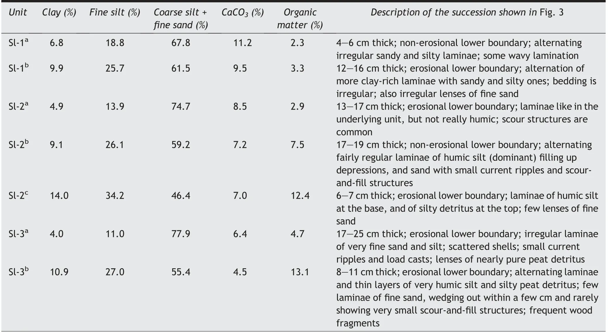
Table 1 Units of the Almere deposits and their main characteristics(modified after Van Loon and Wiggers,1975a,c).
The Almere deposits accumulated in a shallow lagoon and extend over many kilometers, often without distinct interruptions. All over the Noordoostpolder, these deposits consist of clayey silt with varying amounts of peat detritus that was eroded from the shores (and during storms from the lagoonal bottom), with rarely some admixtures of fine sand. It is therefore surprising that locally patches of sand or even pebbly sand occur, which are commonly both under- and overlain by the fine-grained Almere deposits, and that are occasionally (but certainly not always) also surrounded by them. Since the sandy material occurs as isolated patches,without a gradual lateral change in grain-size, and without being interconnected, this cannot be explained by a temporary change in the source area or a change in the transport route of these sediments. It must therefore be deduced that the cause of these sandy patches must be a local feature.
3. The sand bodies
Three different types of sand bodies have been found. They differ primarily in their grain-size distribution. The three types have been named informally(after the names of the villages where they are well developed) the “Tollebeek deposits”, “Nagele deposits” and “Kuinre deposits”. Van Loon (1981)considered them as members of the Groningen Formation, but the most recent lithostratigraphic nomenclature of The Netherlands(Weerts et al.,2000)does not consider these exceptional sand bodies at all,and includes them in the marine Naaldwijk Formation,even though they were formed in a brackish lagoon.
3.1. The Tollebeek deposits
One of the sandy deposits (Fig. 7) is much coarser than the other two. This sand, which forms bodies of up to about 2 m thick, must have been deposited so quickly that the increasing pressure exerted by the newly deposited sand caused pore water to escape through water-escape structures(Fig.8).The medium to very coarse sand may locally contain small pebbles.The composition of these pebbles and of the heavy minerals indicates that they must have been derived from glacial diamictons, deposited during the Saalian glaciation.Indeed,such diamictons are present in the area, locally as highs that formed islands (Urk and Schokland) in the lagoon (Fig. 9), but that are now small hills in the reclaimed Noordoostpolder. The diamictons (assigned to the Drenthe Formation) have certainly been eroded,as is proven by the presence of an abraded area (currently a nature reserve) where huge boulders,together with cobbles and pebbles,all of Scandinavian origin are concentrated as an abrasion remnant(Fig. 10).

Fig.3 Representative and almost complete succession of the Almere deposits,visible in the cleaned wall of a ditch in the Noordoostpolder.The Almere deposits rest on a layer of detritus gyttja(d.g.)belonging to the Flevomeer deposits and is overlain by the more marine Zuiderzee Member(ZM),formed between roughly 1600 and the closure of the lagoon by the Enclosure Dam(1932 A.D.).The Almere deposits consist of several units (indicated at the right), which are detailed in Table 1. Length of spade 145 cm.
The eroded/abraded particles of the glacial diamictons of the Drenthe Formation could not be transported far away, because currents in the lagoon had commonly a low energy (although storm-induced currents could temporarily erode channels in the shallow,fine-grained lagoonal bottom). During storms, which must also be held responsible for the erosion of the glacial diamictons, the currents must have been sufficiently strong to transport the eroded material,depositing the coarsest material first and depositing ever less coarse material downcurrent. This led to elongated sand bodies,for instance in the direct vicinity of the village of Urk, which is built on a boulder clay high.
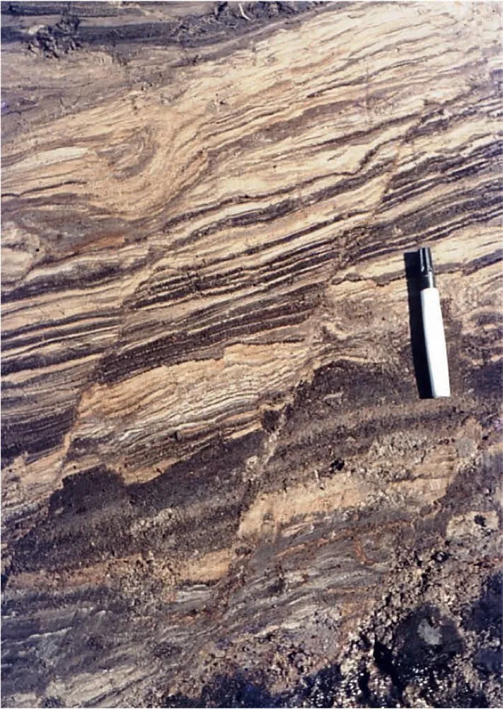
Fig. 4 Synsedimentary faults in the water-saturated Almere deposits (modified after Van Loon, 2019). Pen (12 cm) for scale.
These sand bodies form what we have named the Tollebeek deposits. They cannot be confused with the Drenthe Formation (although they have the same composition), because the Drenthe Formation is a typically massive diamicton, whereas the Tollebeek deposits show abundant sedimentary structures,partly formed during deposition(current ripples),partly postsedimentary processes(e.g.water-escape structures).Moreover, some fragments of lagoonal and marine Holocene fossils may be present, indicating that these sands were deposited during the lagoonal phase(~0-1600 A.D.)when the Almere deposits accumulated as well as during the subsequent more marine phase(1600-1932 A.D.) when the Zuiderzee deposits were formed.

Fig.5 Two examples of the spectacular soft-sediment deformation structure‘gravifossum’:a block of soft(water-saturated)sediment that subsided along complex faults into the also water-saturated sediments below,inducing secondary faults and numerous small folds(from:Van Loon, 2019). Width of Figure A ~60 cm. Length of spade in Figure B ~1.45 m.
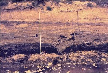
Fig.6 Gravifossum-like deformation structure in Holocene marine/lagoonal sediments exposed in the wall of a drainage ditch in NW France between Calais and Dunkerque. Length of both (identical) scales 1 m.
3.2. Kuinre deposits
During the Weichselian glaciation,coversand ridges had developed over the northern part of The Netherlands, also in the area that became flooded by the sea during the post-glacial sea-level rise,and that is nowadays part of the Noordoostpolder. They were relatively low (maximally a few meters high) but nevertheless were prone to erosion in the shallow water body.And,indeed,erosion took place(Fig.11),during both the lagoonal and the subsequent more marine phase.We call the abraded/eroded sands,which do not constitute a formal stratigraphic unit, “Kuinre deposits”. They occur in numerous places, commonly close to the source(Fig.11).They can be distinguished from the Tollebeek deposits because they lack coarse sand and larger grains. They differ from the Nagele deposits because they are much less well sorted.
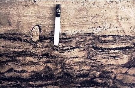
Fig. 7 Coarse sands of the Tollebeek deposits overlying the peat-rich Almere deposits near Urk. Note the presence of a mollusk in living position,suggesting that it was quickly buried under a thick sand layer eroded from the nearby glacial diamictic high.Pen(12 cm)for scale.
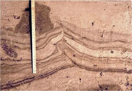
Fig.8 Water-escape structure in the Tollebeek deposits,suggesting a temporarily uncommonly high sedimentation rate.Visible part of the scale is 22 cm.
3.3. Nagele deposits
Morphologically much less well expressed than the boulder-clay highs of the Drenthe Formation are dunes that formed along rivers under the periglacial conditions of the late Weichselian glaciation, when vegetation was absent and sand could be blown out by strong winds and storms from the river beds that fell dry seasonally. The river dunes form part of the Kreftenheye Formation.
Because the river dunes locally reached (or came close to) the lagoonal bottom, they were eroded occasionally (Fig. 12A). Because the river dunes had formed due to aeolian activity, they are well sorted,and consequently also the Nagele deposits are well sorted (Fig. 12B), and grains over 600 μm are almost completely absent;the majority of the grains is in the 105-420 μm range.

Fig. 9 Air photograph (taken between 1920 and 1940) of the island of Urk, which would become a small hill after reclamation of the Noordoostpolder. View towards the SE. Photo from Nederlands Instituut voor Militaire Historie/Wikimedia Commons.
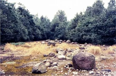
Fig. 10 Concentration of cobbles, pebbles and finer material on top of a glacial diamicton abraded by waves, probably during both the marine and lagoonal development represented by the Zuiderzee and Almere deposits,respectively.The abraded area now forms part of the geological reserve “Van der Lijn” near Urk. Boulder on the right-hand foreground 47 cm wide.
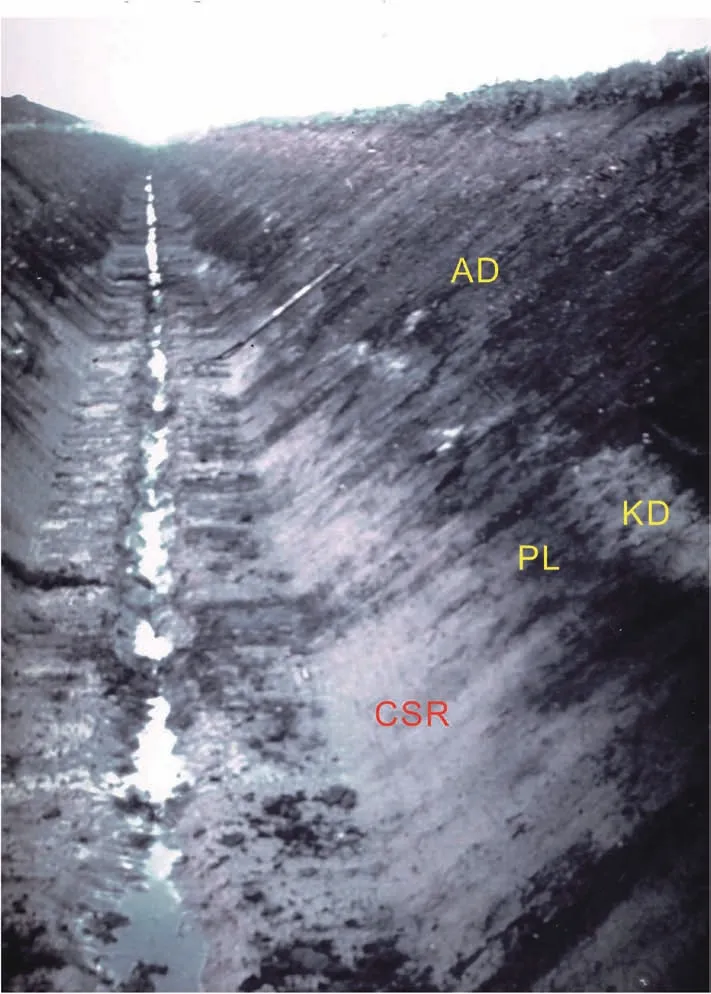
Fig.11 View through a drained ditch,with in the right-hand wall the top of a Pleistocene coversand ridge(CSR:relatively thick lower lightcolored unit with a dipping surface).The coversand ridge became irregularly eroded by waves,and is now overlain by a thin band of Holocene peat (PL: dark), formed by plants of which the roots grew into the coversand, thus making the contact between coversand and peaty layer even more irregular. The peaty layer became, in turn, irregularly eroded by wave action resulting from the ongoing Holocene marine transgression that also locally abraded the coversand ridge and deposited the eroded material as a relatively thin and irregular(light-colored)band of sand(Kuinre deposits:KD).The Kuinre deposits are overlain by the Almere deposits(AD:grayish),which constitute here the topmost sediments. Height of ditch 1.4 m.
According to Van Loon and Wiggers (1977), who proposed to make these sands a formal stratigraphic unit(Nagele Member of the Groningen Formation),two stratigraphically somewhat different sub-units can be distinguished: one that formed during the lagoonal phase, and one that formed during the more marine phase. This implies that the river dunes were eroded only slowly and interruptedly, which may explain why relatively thick successions (>1 m) of the Nagele deposits could accumulate. Such successions show current ripples (Fig. 13) that indicate low-energy conditions, which is confirmed by the presence of peat detritus in the form of small patches and some streaks.
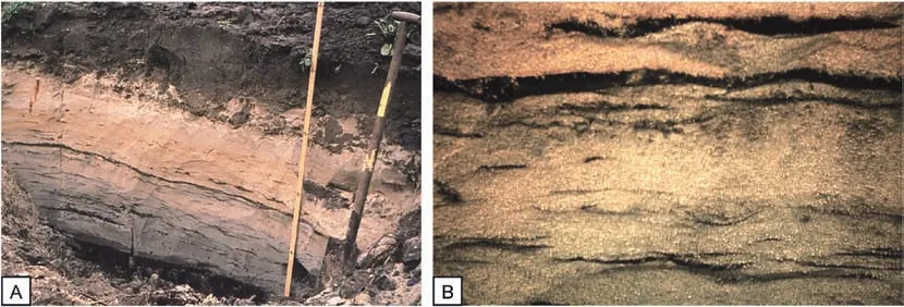
Fig. 12 The Nagele deposits. A) Characteristic appearance of the Nagele deposits in an artificial exposure near the village of Nagele with small ripples,flasers,and scours.The exposed sand is~60 cm thick(scale in cm);length of spade is~1.25 m;B)Detail of the Nagele deposits shown in Fig. 13. Current ripples indicate that the sand was supplied through currents; the levels and intercalations of reworked peat and gyttja indicate more quiet phases with settling from suspension. Width of photo ~6 cm.
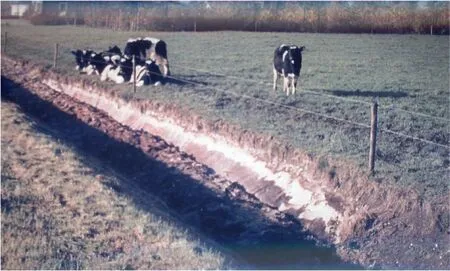
Fig. 13 Top of a Weichselian river dune, exposed in a ditch in Zuidelijk Flevoland. The bright sediment is reworked fine material (Nagele deposits).
4. Discussion
The Holocene succession in the Noordoostpolder consists almost everywhere of peat and fine-grained clastics (almost exclusively clay and silt), with shells as coarser particles. Only at the mouth of the IJssel River, where a small delta-like body developed, some sands were deposited(the Ramspol deposits),whereas some reworked material locally forms the Blokzijl deposits consisting of calcareous very fine sand with 0-5% clay (Stolp, 1999). Both the Ramspol and the Blokzijl deposits are of so little importance that we do not pay attention to them here.
4.1. Sources of the sands
The Tollebeek, Kuinre and Nagele deposits represent sandy patches that are up to maximally some 2 m thick (commonly considerably less) and that may extend laterally up to some hundreds of meters.Their presence and their spatial distribution are inconsistent with the overall sedimentary setting and granulometry of the lagoonal deposits. This raises the question of how these sands came into being, and why three different types of sandy patches can be distinguished.As explained above, we deduce that they formed by abrasion of relatively high parts of the Pleistocene sandy substratum of the Holocene lagoon. It might be questioned, however, whether the sands could have been supplied from outside the lagoon. Considering the palaeogeographical context (a lagoon with a relatively small opening toward the Wadden Sea, in a lowland area from where one large river and some smaller streams discharged into the lagoon), only two possible extrabasinal sediment sources are present:the Wadden Sea and the river/streams.
The sediments of the Wadden Sea are,like those in the lagoon, fine-grained, but the silt/clay ratio is 1:3 versus 3:1 in the study area. This seems not really relevant,however,since the high silt ratio in the study area is related to flocculation. More importantly, the Wadden Sea contains little sand,and certainly not such coarse sand (with occasionally pebbles) as the Tollebeek deposits. Moreover, the (relatively) coarse material from the Wadden Sea that entered the lagoon was almost completely deposited in delta-like deposits that formed in the area where now the Enclosure Dam is situated, so that hardly any sand from the Wadden Sea could reach the study area. Moreover, the distribution of the sands does not indicate any transport route from the Wadden Sea to the interior of the lagoon, so that the distribution of the sandy patches cannot be explained by supply of sand from the Wadden Sea.
The IJssel River and the smaller streams can, for similar reasons, not be held responsible either,although they supply some sand (which is deposited close to their mouth). The most convincing argument is,however,that the mineralogical composition of the river sediments differs significantly from those of the lagoonal sands.
4.2. Dating
An important question is, obviously, when the various deposits formed. As mentioned above, the substratum of the Holocene lagoon consists of Pleistocene sediments,mainly Weichselian sands and some Saalian glacial diamictons. The Holocene peat that developed on the inclined Pleistocene surface during the post-glacial sea-level rise (Fig. 2) became eroded(Fig.14)in the lagoon where the Almere deposits and the sandy units under study here were deposited.Because of this reworking, the abundant peat in the Almere deposits(Fig.15)and sands cannot be used for C-14 dating.
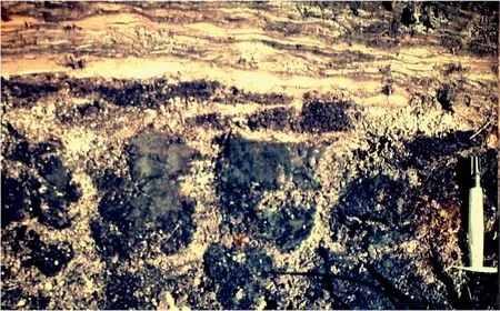
Fig.14 Almere deposits overlying the Holocene peat.During phases of dry weather,the peat formed shrinking fissures,which made it highly susceptible to wave erosion. This resulted in the abundant small masses of reworked peat in the Almere deposits. Pen (12 cm) for scale.
Fortunately, the Almere deposits can stratigraphically be subdivided into seven units,the ages of which are all well-known (Wiggers, 1955). This is primarily due to archeological dating: several cities and villages along the lagoon led to frequent transport of goods by ships, and the sometimes rough weather caused hundreds of ships to be wrecked in the course of centuries. Dozens of these ships have been found embedded in the sediments (Fig. 16), particularly during building activities after the area had been reclaimed. The goods found onboard allow precise dating (commonly with an accuracy of the order of some ten years). The datings prove that both the sediments below and above the sands date from a time span that started around 1200 A.D., so that a late Holocene age is indisputable.
4.3. Relationship of the Holocene sands with the Pleistocene substratum
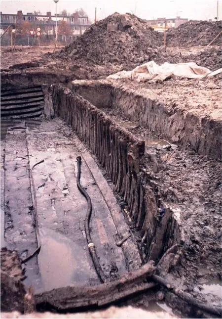
Fig.16 Excavation in Zuidelijk Flevoland of one of the numerous ships that were wrecked in the area during the time span of~1250-1600 AD(from Van Loon, 2019).
In many cases a spatial relationship is established between the Holocene sands with nearby Pleistocene‘highs’, constituted by glacial tills, coversand ridges and river dunes. These highs were, though commonly less than maximally a few meters high,except for the glacial tills, prone to abrasion by waves, particularly during storms,that reached the bottom in the shallow lagoon. The abraded material was commonly transported over short distances only: after a storm had stopped, quiet conditions prevailed again, and the(relatively) coarse abraded material was therefore transported mostly in the direct vicinity of the high(Fig.17).Occasionally it was not even transported far enough to leave the high, so that it forms a cover of reworked material on top of the high. Tidal activity may have caused that the abraded material did not become redistributed all around the source, but mostly at a downcurrent direction.This is particularly clear with the Tollebeek sands near Urk, where they can be found as an elongated deposit (known as the‘tail of Urk’).
A spatial relationship between the sandy deposits and the Pleistocene highs cannot, however, be established in all cases. This must be ascribed to the fact that some of the Pleistocene sand bodies that served as a source may have been eroded completely,which is understandable because some of them (particularly coversand ridges and river dines) had small dimensions. In such cases, a relationship can be established,however,on the basis of grain size,sorting and heavy-mineral species.
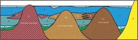
Fig. 17 Schematic model (not to scale) of the genetic relationship between the Pleistocene highs in the lagoon and the sandy patches embedded in the fine-grained lagoonal sediments(modified after Van Loon,1981).Inclined Pleistocene sediments(P,yellow,right-hand part of the figure), mainly sands and gravels, form the substratum of the lagoon, which had an irregular topography. This was due to ‘highs’consisting of glacial diamicts of the Drenthe Formation(D,red),coversand ridges of the Twente Formation(Tw,yellowish/brownish/orange),and river dunes of the Kreftenheye Formation (Kr, brown). The Holocene succession building up in most of the lagoon (in between the Pleistocene highs) consists of the transgression-related peat of the Wold Formation (W, green), clays and silts of the lacustrine Flevomeer deposits(F,light blue),silts and clays of the lagoonal Almere deposits(A,medium blue),silty clays of the marine Zuiderzee deposits(Z,dark blue)and the silty/clayey sediments of the IJsselmeer deposits(Y,light blue)consisting of reworked Zuiderzee and Almere deposits,formed after closure of the Enclosure Dam. Particularly during storms, the Pleistocene highs became abraded by wave action. Abrasion of the diamicts of the Drenthe Fm. resulted in the coarse-sandy Tollebeek deposits (T, red, with blue intercalations). Abrasion of the coversand ridges of the Twente Fm.resulted in the Kuinre deposits(K,orange with blue intercalations).Abrasion of the river dunes of the Kreftenheye Fm. resulted in the Nagele deposits (N, orange with blue intercalations). The abraded sands tend to be connected to the source (see, for instance,the Tollebeek deposits to the left of the Drenthe high),but they may also have become disconnected(see the Tollebeek deposits to the right of the Drenthe high).Rarely,the sands of different sources reach each other,but this occurs occasionally(see the interfingering of the Kuinre and Nagele deposits).
It is interesting in this context that the Noordoostpolder is largely used for agriculture, and that activities like ploughing have in the course of decades made disappear almost all original height differences.Particularly the sandy patches can,as a rule,no longer be seen in the agricultural fields. Yet, some of them are still traceable,because the fine-grained and peaty sediments underwent significant compaction (due to groundwater lowering) after the Noordoostpolder had fell dry; the sand bodies underwent much less compaction,so that they became initially visible in the years after reclamation as relatively higher parts in a landscape where the lagoonal bottom formed a very flat surface. Nowadays, these earlier differences in height can still be observed by undulations in roads,as these have not been leveled.
4.4. Sandy patches elsewhere in the lake IJssel area
Comparable sand patches occur in the other reclaimed polders (Oostelijk Flevoland en Zuidelijk Flevoland). Much less is known, however from the western part of Lake IJssel.Sedimentological research of the bottom sediments is, unfortunately, not well possible,which is regrettable because particularly the northern part of the Markermeer is expected to have bottom sediments that are well comparable to those in the Noordoostpolder. It is not known, however,whether sands derived from boulder clays,river dunes and coversand ridges occur also in this part of Lake IJssel.
5. Conclusions
The fine-grained Holocene sediments that were deposited during the past 2000 years in a lagoon that had developed in the central part of The Netherlands are locally interrupted by - commonly not interconnected-patches of sands.They can be studied in the walls of some 1500 km of ditches of about 1.4 m deep in a reclaimed part (the Noordoostpolder). The grain size of these sandy patches does not fit in the palaeogeographical context of the lagoon. Detailed mapping has shown that almost all these sandy patches occur along-or,occasionally,on top of-Pleistocene sediments that formed highs in the lagoon, mostly subaqueously (coversand ridges and river dunes), occasionally subaerially (the former islands of Urk and Schokland, consisting of glacial tills).
The sandy patches were formed by wave-induced abrasion of the highs. The distribution of the sandy patched excludes an extrabasinal origin, and their mineralogical content supports this finding. It must therefore be deduced that the palaeogeography of the local Pleistocene in the area with its slightly irregular topography controlled the sedimentary pattern in the Holocene lagoon.
Conflicts of interest
The authors declare that they have no known competing financial interests or personal relationships that could have appeared to influence the work reported in this paper.
Acknowledgements
We thank the farmers in the Noordoostpolder for their permission to carry out our geological investigations on their properties.We are grateful to the editors of the Dutch-language journal ‘Grondboor &Hamer’ of the Nederlandse Geologische Vereniging(Geological Society of The Netherlands) for their permission to reproduce some photographs published earlier in their journal. We also thank the editors and two anonymous reviewers for their comments on the original manuscript, which helped to improve it. This study was supported by the China-ASEAN(Association of Southeast Asian Nations) Maritime Cooperation Fund Project (grant No. 12120100500017001) and the National Natural Science Foundation of China (grant No.41972146).
杂志排行
Journal of Palaeogeography的其它文章
- Genesis and mechanisms of organic matter enrichment of the Hongshuizhuang Formation in the Zhoukoudian area of Jingxi sag, North China
- Scales in the Early Cretaceous bird Gansus from China provide evidence on the evolution of avian scales
- A new oospecies of Shixingoolithus(Shixingoolithus qianshanensis oosp. nov.)from the Qianshan Basin, Anhui Province, East China
- Sedimentology and foraminiferal paleoecology of the exposed Oligocene-Miocene Ogwashi-Asaba Formation in Issele-Uku area, Anambra Basin, southern Nigeria: A paleoenvironmental reconstruction
- Application of remote sensing in the description of fluvial system in dryland: A case study of Golmud distributive fluvial system,Qaidam Basin, NW China
- Mid-Cretaceous Hainan back-arc basin: record of the sustained extension of South China margin