Consistency analysis of GRACE and GRACE-FO data in the study of global mean sea level change
2022-07-15LeChangWenkeSun
Le Chang , Wenke Sun
a College of Geodesy and Geomatics, Shandong University of Science and Technology, Qingdao, 266590, China
b Key Laboratory of Computational Geodynamics, University of Chinese Academy of Sciences, Beijing,100049, China
Keywords:GMSL GRACE GRACE-FO Altimetry Argo
ABSTRACT Global mean sea level (GMSL) change is one of the important indicators of global climate change and is a crucial scientific issue of continuing interest. As satellite altimeter data, the Gravity Recovery and Climate Experiment (GRACE) and Argo continue to be updated, especially with the release of GRACE Follow-On (GRACE-FO) data, making it necessary to combine these latest data to estimate sea level change. Determinations on whether the GRACE and GRACE-FO observation systems provide unbiased global observation data have not been effectively evaluated. Therefore, this research mainly investigated the consistency of GRACE and GRACE-FO observation data in studying GMSL change. By comparing the sum of the GMSL calculated by the two gravity satellites and Argo data with the GMSL calculated by satellite altimeters, the discrepancy between GRACE-FO + Argo and satellite altimeter data is about 7.9 ± 2.3 mm, which is likely derived from the inconsistency between GRACE and GRACE-FO data.
1. Introduction
Sea level change is a direct reflection of global climate and environmental change. It is affected by both human activities and natural factors, but also exerts an important impact on human production and livelihoods. GMSL change can be divided into two forms: first, the change of seawater volume caused by the change of seawater temperature and salinity, of which the temperature is the main factor, known as steric sea level change; and second,seawater mass change caused by water exchange between land and ocean [1]. Over the past 50 years, an average of 93% of the excess heat in the climate system due to greenhouse gas emissions has been stored in the oceans, while the remaining 7% has warmed the atmosphere and land[2].Owing to continuous global warming, the heat content of the ocean is increasing, the volume of seawater is expanding, and the steric sea level is rising [3]. The massive loss of glaciers on land [4], along with the loss of ice sheets in Greenland and Antarctica have led to an increase in the mass of seawater and rising sea levels [5]. Since 1992, satellite altimetry has been able to accurately measure global sea level,and the change rate of GMSL has been determined to be approximately 3 mm/year [6,7]. Since the launch of the Gravity Recovery and Climate Experiment (GRACE) gravity satellites in 2002,changes in the mass of the global ocean have been accurately measured [8]. Argo floats have covered most parts of the ocean since 2005. These floats can regularly measure the temperature and salinity of seawater above 2000 m on a global scale,obtaining the data which can be used to calculate the steric sea level change[9]. With the increase of measurement methods, satellite altimetry,GRACE,and Argo have been used to examine and analyze sea level change [10-14]. The sum of the GMSL calculated by GRACE and Argo is in good agreement with the GMSL calculated by satellite altimetry.
Global sea level change is a dynamic nonlinear change phenomenon, which has exhibited an accelerating trend in recent years. Therefore, this marine characteristic requires constant observation and analysis, for scientists to grasp the main factors affecting sea level change and predict its future fluctuations more accurately. Since the successful launch of the GRACE-FO gravity satellites in 2018, about 3 years of observations have been made,although there is a gap of about one year between GRACE and GRACE-FO data. At present, some studies have interpolated this data gap with other auxiliary data to study the variation of terrestrial water reserves[15,16],and the mass change of polar ice sheets [17]. Currently, there are fewer studies combining GRACE and GRACE-FO data for GMSL change. Therefore, it is worthwhile to make sure whether the observation systems of GRACE and GRACE-FO are consistent and can be jointly utilized to investigate GMSL change. In this study, we examined and discussed the consistency of GRACE and GRACE-FO observations in studying GMSL changes by comparing the sea level changes calculated by the two gravity satellite systems,and Argo data with the sea level changes calculated by satellite altimeters. We found some differences between them, which were also reported by Chen et al. [18].
2. Data and methods
2.1. Altimetry data
The global mean sea level data was provided by 5 institutes:
1. Archiving, Validation and Interpretation of Satellite Oceanographic (AVISO).
2. Commonwealth Scientific and Industrial Research Organization(CSIRO) [19].
3. National Oceanic and Atmospheric Administration(NOAA).
4. National Aeronautics and Space Administration (NASA).
5. University of Colorado(CU) [20].
Those products have been corrected for the effects of ionospheric delay,wet and dry troposphere,electromagnetic error,solid Earth and ocean tides, and the glacial isostatic adjustment (GIA)effect was also removed using a value of -0.3 mm/year [21]. The GMSL of those data were estimated between 66S and 66N [22].Those time series were resampled to monthly data from January 2005 to July 2020.The ensemble means of the GMSL provided by 5 institutes were calculated and smoothed with a 6-month sliding window.
The grid altimeter dataset provided by AVISO was also used.These data were processed by the SSALTO multi-mission ground segment/Data Unification and Altimeter Combination System(SSALTO/DUACS),which combines all of the satellite data(Jason-3,Sentinel-3A,HY-2A,Saral/AltiKa,Cryosat-2,OSTM/Jason-2,Jason-1,Topex/Poseidon, Envisat, GFO, ERS-1 & 2). We used the Delayed Time Maps of Sea Level Anomaly (DT-MSLA) monthly mean sea level anomalies data relative to the mean sea level from 1993 to 2012, with a spatial resolution of 1/4×1/4Mercator grid from January 1993 to September 2019. This product has been corrected for the effects of ionospheric delay, wet and dry troposphere,electromagnetic error, solid earth, and ocean tides. Thus, the GIA effect was removed [23].
2.2. GRACE gravity data
The GRACE and GRACE-FO data were provided by the Center for Space Research (CSR) of the University of Texas at Austin, the Jet Propulsion Laboratory (JPL), and the Helmholtz-Centre Potsdam -German Research Centre for Geosciences (GFZ). These data were monthly Release 06 Level-2 solutions in spherical harmonic coefficients (GSM), and we used the GSM of 60. We added back the degree-1 coefficients(GRACE Technical Note 13)[24],and replaced the C20s coefficients [25]. The glacial isostatic adjustment (GIA)effect was removed using the ICE6G-D model[23].Both the GRACE and GRACE-FO have subtracted the average of the GRACE data between 2005 and 2010 to give them the same baseline. Then the forward model reported by Chen et al. [26] was used to calculate the global mean sea level change caused by water mass redistribution. We used the GRACE data from January 2005 to June 2017,and GRACE-FO data from June 2018 to July 2020. The ensemble mean of the time series was calculated and smoothed with a 6-month sliding window.
2.3. Argo data
The Argo data used was provided by 3 institutions: the Scripps Institution of Oceanography (SIO), the International Pacific Research Center(IPRC)[9],and the Japan Agency for Marine-Earth Science and Technology (JAMSTEC). The spatial resolution of Argo data is 1× 1, covering the global area between about 65S and 65N.This product provides the seawater temperature and salinity data from the ocean's surface to the depth of 2000 m. The data provided by the 3 institutions were stratified into 58 layers for the SIO, 25 layers for the JAMSTEC, and 27 layers for the IPRC. We utilized the seawater temperature data from January 2005 to July 2020. The thermosteric and halosteric sea level were calculated using the method provided by Cazenave and Nerem [1]. The ensemble mean of the time series was calculated and smoothed with a 6-month sliding window.
3. Global mean sea level change
3.1. GMSL change obtained by altimetry, GRACE and argo
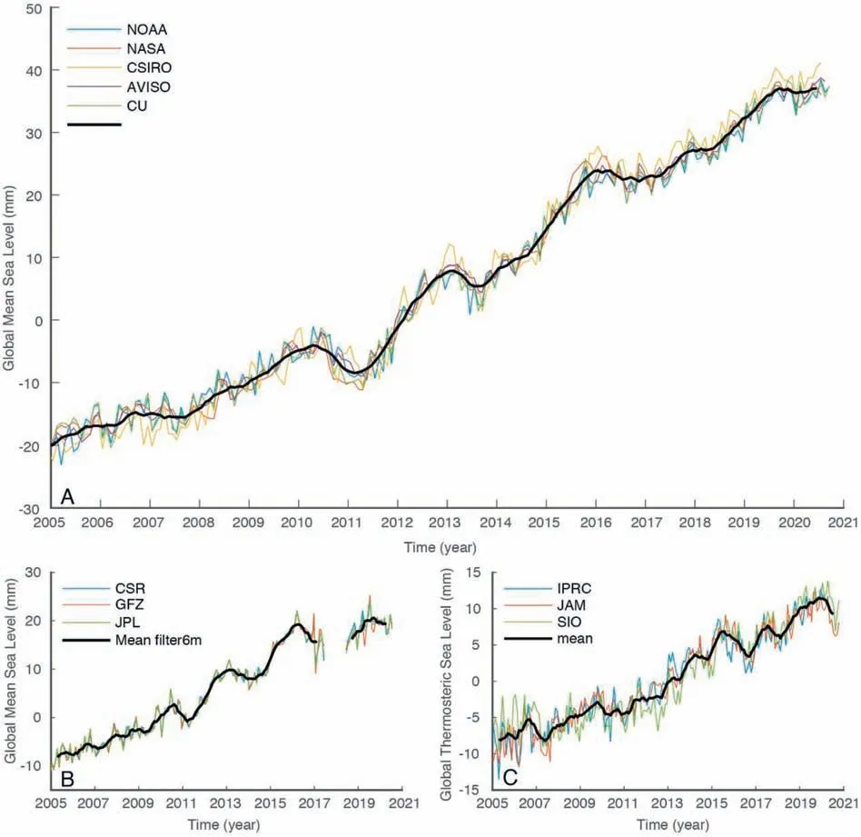
Based on the method described in Section 2, we obtained the time series of GMSL change, seawater mass change and thermosteric sea level change using altimetry, GRACE and Argo data,respectively, as shown in Fig. 1, in which the seasonal variations(include annual signal) of all the time series have been removed.Fig. 1(A) is the GMSL change time series obtained by satellite altimetry from 5 institutes,and the black curve is the mean result.The GMSL trend of AVISO,CSIRO,CU,NASA,NOAA,and their mean were 3.93, 4.20, 3.90, 3.95, 3.85, and 3.96 mm/year, respectively.They also provided the uncertainty in the GMSL trend of approximately 0.4 mm/year at the 90%confidence level.It can be seen that the sea level is continuously rising and there is a large inter-annual fluctuation, which is mainly affected by El Ni˜no-Southern Oscillation (ENSO) [22].
As shown in Fig.1(B),we used GRACE and GRACE-FO data from the CSR,GFZ,and JPL to calculate the time series of sea level change caused by mass changes in global seawater.It can be seen from the Fig.1,in which the black curve is the average value of those 3-time series. The trends of each GRACE time series were 2.07 ± 0.10,2.11 ± 0.10, and 2.08 ± 0.10 mm/year, respectively, with good agreement within the uncertainty range. We used the mean value as the final result of GRACE and GRACE-FO data.There is about one year gap between the GRACE and GRACE-FO data, and we did not interpolate the missing data.

Fig.1. Time series of GMSL change. (A) Time series of GMSL calculated by altimetry, with their seasonal variations removed; (B) GMSL change caused by seawater mass change calculated from GRACE and GRACE-FO data provided by the three institutions,with their seasonal variations removed;(C)Global mean thermosteric sea level change calculated by Argo data provided by the three institutions. The seasonal variations have been removed. The black curves are their mean time series.
Because the salt capacity of the entire ocean is nearly constant and the water reserves in the atmosphere are small, the contribution of these factors to the GMSL trend is negligible [27-29]. The redistribution of the salt and heat in the ocean also causes changes in seawater volume,but these changes have negligible effects [30]on the GMSL. We utilized the temperature data from Argo floats provided by the IPRC,JAMSTEC and SIO to calculate the global mean thermosteric sea level change, and we also considered the deep ocean effects[31],as shown in Fig.1(C),in which the black curve is their average value.The trend of global mean thermosteric sea level were 1.45±0.10,1.49±0.09,and 1.44±0.12 mm/year,respectively.The time series from the 3 institutions do not match as well as the GRACE data,but their trends are consistent with each other within the uncertainty range.Therefore,we used their averages as the final result of the global mean thermosteric sea level change.
3.2. Systematic difference between GRACE and GRACE-FO
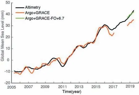
We superimposed the global mean thermosteric sea level change calculated from the Argo data with the results from the GRACE and GRACE-FO data, and then compared it with the GMSL change obtained from satellite altimetry, as shown in Fig. 2. In early 2016, however, the deviation began to increase, which may be because the batteries and fuel used by GRACE were almost exhausted from early 2016 to June 2017, leading to a larger GRACE error [32]. We found that the sum of the GRACE-FO and Argo data was significantly different from the altimetry, although their variation trends were consistent in the period of GRACE-FO.The green curve in Fig. 2 is the red curve plus 7.9 mm, so the change between the two curves is the same. This discrepancy between GRACE-FO + Argo and satellite altimeter data is likely derived from the inconsistency between GRACE and GRACE-FO data. Due to the limitation of the length of Argo data, we were unable to get longer time series. As the data accumulate, we may be able to further identify the causes of this discrepancy. This discrepancy prevents us from combining GRACE and GRACE-FO to study the long-term trends of GMSL caused by seawater mass change.

Fig.2. Comparison of GMSL change calculated by altimetry data and the sum of GRACE and Argo. The seasonal variations have been removed, and these curves were smoothed using a 6-moth sliding window.
In conclusion, by comparison with the GMSL changes obtained from altimetry, it revealed that there may be the systematic difference of approximately 7.9 ± 2.3 mm between GRACE and GRACE-FO in the study of GMSL change caused by seawater mass.We employed the twice average root-mean-square errors between the GMSL changes calculated from the altimeter, GRACE-FO, and Argo data as their respective errors, which were 1.7 for the altimeter, 0.8 mm for GRACE, and 1.3 mm for Argo within a 95%confidence interval. Their uncertainties are estimated as the standard deviation between the different constituting the ensembles. Meanwhile, the GMSL uncertainty reported in Ablain et al. [33] was also considered. Therefore, according to the law of error propagation, the calculated error between the Altimeter-Argo and GRACE-FO was 2.3 mm.
4. Discussion
There are many reasons for the systematic difference between the GMSL obtained by the Altimeter and GRACE-FO + Argo data,indicating the necessity for a comprehensive analysis. We analyzed the impacts of different data processing methods,including the substitution of low-order terms (C30) and different filtering methods. It turned out that these different processing methods exerted little effect on our results,which also was proved by Chen et al. [18].
We also considered the influence of the offshore area,since the different coverage areas of the altimeter, GRACE and Argo data. To reduce the error caused by different data processing methods, we performed the same processing steps for all data. GRACE gravity data were provided in the form of spherical harmonic coefficients of 60.To reduce errors,GRACE data need to be filtered using P4M6 decorrelation[34]and a Gaussian smoothing filter of 300 km[35].We converted the sea level change that was calculated by altimeter(grid data from AVISO, detail in supporting information) and Argo into spherical harmonic coefficients of 60, and then conducted P4M6 decorrelation and a Gaussian smoothing filter of 300 km,which also been done for GRACE data. While altimetry and Argo data do not cover the entire ocean,GRACE data are from the entire ocean.Therefore,we employed the common coverage area of the 3 types of data to calculate the GMSL change using the weighted average. Taking into account the fact that GRACE data experience signal leakage at the land-sea boundary, we excluded the coastal ocean areas within 300 km of coastlines. The results are shown in Fig. 3, which also turned out that the GMSL change is very small,and it was also confirmed by the comparison between the sum of the GRACE and Argo and the altimetry before 2016.
For the whole ocean, the amount of salt is conserved, and the change of seawater salinity is related to the increase and decrease of freshwater [36]. As the decreases of salinity of seawater, the density of seawater decreases and the volume of seawater increases. As mentioned above, the contribution of salinity change to the GMSL trend is negligible, but the halosteric sea level has an inter-annual fluctuation. We calculated the global mean halosteric sea level change using the Argo data provided by the 3 institutes,as shown in Fig.4.The halosteric sea level calculated by Argo data from IPRC and JAMSTEC decreased in our study period, and the rate of decline accelerated after 2015, which indicated the density of seawater was increasing. The water mass was rising during this period [37,38], which will lead to a decrease in the density of seawater. The salinity data of IPRC and JAMSTEC was drifted after 2015. The halosteric sea level change calculated by SIO data was consistent with the actual situation, which may be normal.However, the amplitude of the inter-annual fluctuation was less than 2 mm, which is unlikely to cause such a systematic difference.

Fig.3. Comparison of GMSL change calculated by altimetry data and the sum of GRACE and Argo after the same process. The seasonal variations have been removed, and these curves were smoothed using a 6-moth sliding window.

Fig.4. The global mean halosteric sea level change calculated by Argo data from three institutions. The seasonal variations have been removed, and these curves were smoothed using a 6-moth sliding window.
The global mean thermosteric sea level changes calculated by 3 Argo products were consistent. In addition to the Argo buoys,there are currently other instruments that measure seawater temperature profiles. Although the data are relatively sparse, they still reflect the overall variation of the global mean seawater temperature. Cheng et al. [39] gridded all available observations from the World Ocean Database (WOD) of the National Oceanic and Atmospheric Administration/National Center for Environmental Information (NOAA/NCEI). The primary input data is Expendable Bathythermograph (XBT), and other data, such as Conductivity-Temperature-Depth (CTD), Mechanical Bathythermograph (MBT), moored buoys, gliders, etc. This dataset was provided by the Institute of Atmospheric Physics (IAP) Chinese Academy of Science. We used this dataset to calculate the global mean thermosteric sea level change and showed it in Fig. 5. We can see that it is a little lower than the Argo time series in the period of GRACE-FO, which may be due to insufficient data.Therefore, we considered the temperature data of Argo to be correct, and it should not be responsible for this systematic difference. According to Chen et al. [18], the Jason-3 has a slight radiometer drift, which is minor and negligible.
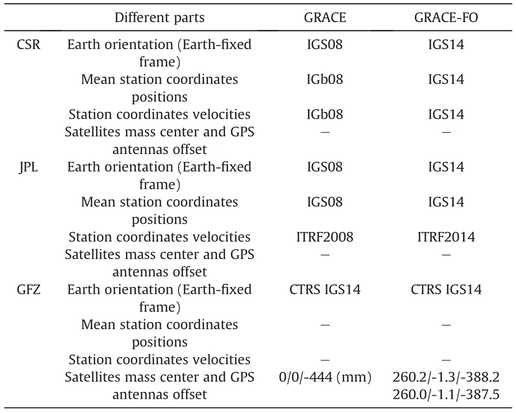
According to the report of Loomis et al.[40],one of the GRACEFO accelerometers has elevated noise levels, and it was corrected using an accelerometer transplant approach developed by Bandikova et al. [41], which was originally used for the GRACE at the end-stage. However, if this was the cause of the systematic difference, it should be appeared at the end of the GRACE mission,because one of the accelerometers was turned off in October 2016.The difference at the end of GRACE mission was variable, which may be caused by the insufficient measurement as shown in Fig.1 by Loomis et al.[40].This systematic difference may be due to the inconsistency in the processing of data between GRACE and GRACE-FO. Based on the data processing standard documents provided by the CSR, JPL and GFZ, we presented the different components of the GRACE and GRACE-FO systems [42-44]. As shown in Table 1,there may be other factors that are not provided in the processing documentation.

Fig.5. The comparison between global mean thermosteric sea level change calculated by three Argo and IAP data. The seasonal variations have been removed.

Table 1 Different elements of GRACE and GRACE-FO data processing.
5. Conclusions
In this study, the latest satellite altimetry data, gravity satellite data, and Argo observation data were utilized to examine GMSL change.When comparing the sum of the GRACE and Argo with the satellite altimetry,we found that there was a systematic difference of 7.9 ± 2.3 mm of sea level change between the Altimeter and GRACE-FO+Argo,which might be derived from the inconsistency between GRACE and GRACE-FO data.As the GRACE-FO system has not been observed for a long time, further accumulation of observation data is needed to analyze the consistency of the two observation systems more accurately. Further investigation of the possible reasons for this systematic difference is also necessary.
Author statement
Le Chang:
Process data and analyze results,Writing.Wenke Sun:
Reviewing and Editing, Supervision, Ideas.Con
flicts of interest
The authors declare that there is no conflicts of interest.
Acknowledgments
This research was supported financially by the NNSFC(41774088, 41331066, 42104084, and 41474059) and the Key Research Program of Frontier Sciences CAS (Chinese Academy of Sciences) (QYZDY-SSW-SYS003). The GRACE and GRACE-FO data were provided by the Center for Space Research (CSR) of the University of Texas at Austin, the Jet Propulsion Laboratory (JPL), and the Helmholtz-Centre Potsdam - German Research Centre for Geosciences(GFZ),those data could be download from the website(http://icgem.gfz-potsdam.de/series).The Argo data were provided by the Scripps Institution of Oceanography(SIO),the International Pacific Research Center (IPRC), and the Japan Agency for Marine-Earth Science and Technology (JAMSTEC), and they could be downloaded from this website (https://argo.ucsd.edu/data/argodata-products/). The altimetry data were taken from the AVISO,CSIRO,NOAA,NASA,CU(https://sealevel.colorado.edu/).The grided altimetry data was taken from the AVISO (ftp://ftp.aviso.altimetry.fr/global/delayed-time/grids/climatology/monthly_mean/). The data we used to are all available for free on the website of each organization.We thank LetPub(www.letpub.com)for its linguistic assistance during the preparation of this manuscript.
杂志排行
Geodesy and Geodynamics的其它文章
- A SCR method for uncertainty estimation in geodesy non-linear error propagation: Comparisons and applications
- A combined denoising method of empirical mode decomposition and singular spectrum analysis applied to Jason altimeter waveforms: A case of the Caspian Sea
- Determination of altitudes of the three main Ecuadorian summits through GNSS positioning
- Dual threshold search method for asperity boundary determination based on geodetic and seismic catalog data
- Genetic Nelder-Mead neural network algorithm for fault parameter inversion using GPS data
- Analysis of the common model error on velocity field under Colored noise model by GPS and InSAR: A case study in the Nepal and everest region
